
Where does nature exist, one might ask, in the city? If nature is often imagined as removed from the city–and perhaps only introduced to it in a form of street art that commemorates the remove, as this recent mural commemorating the site of the studio of the Japanese-American artist Chiura Obata, who was so enamored of Yosemite Park, and taught in U.C. Berkeley long before he was incarcerated by the War Relocation Authority during World War II, the appearance of a modern mural of the park clashes slightly with its semi-urban setting at 2518 Telegraph Avenue, on an old power station–

The sense of disconnect between man-made and natural structures is inverted by the energetic environmentalist activists from “Nature in the City,” a local non-profit long dedicated to preserving the city’s open space–that seeks to direct our attention to the above-ground natural wealth that make the city so livable. The 2018 map they’ve produced invites attention to the complexity of its ecosystem all too often overlooked in its built space, and a far more detailed local view of the abundance of natural wealth that they same city contains–and indeed, if one scrutinizes the map, abounds.
The map does not examine the recognizable habitats of urban fellow-residents–from pigeons, raccoons, to rodents–or the imagined habitats within urban street murals–

–but rather actively invite viewers to attend to the spaces where actual native species from a larger ecosystem, often not associate with the urban environment, inhabit San Francisco, and reveals the vitality of the city as a space, coincident with but outside of the built environment that has dominated most of our most familiar mapping tools.
For over thirty years, Nature in the City has raised consciousness by mapping San Francisco’s open spaces and parks; the recent version more fully foregrounds the nourishing of a range of habitats, from its bayshore to its urban space, in a broader ecosystem. The result is a counter-cartography to the city as an ecosystem for cars, unpacking non-grey spaces of the map and questioning the clearly segregated divide between greenspace and greyspace on the surface of our maps, which privilege the navigation through paved space.
Creation of a paper map, indeed, that can be scrutinized in detail and materially held, recuperates an iconography of cartography through a rich availability of open data, in ways that make in data rich, but not data-centric. The printed map is itself almost an anomaly in the age of Landsat. “Been years since I looked at a real map,” comments a character in 1992 in Don DeLillo’s epic of post-war America, Underworld (1997), a micro-history of attitudes to place and space after the Cold War has thawed, that looks back at a lost stability of the world bemoaned after the end of balance of power, in a conversation that turns to the interest in obtaining g some old maps to recuperate a sense of local (if not global) stability and mental health.
“It’s a sort of Robert Louis Stevenson thing to do,” Nick Shay muses. “We have maps of highways and motels. Our maps have rest stops and wheelchair symbols.” Shay thinks of the map as a way to access a past world, or examine a lost life. The new iconography used to map the overlap of an ecosystem in urban space requires a new conventions for a new set of data, and the focus on trees, and the magnification of what greenspace does in a city, and how it acts to create corridors for wildlife, suggests a form of cartographic activism to appraise the future location and role of nature in a city.
The paper map functions, unlike the monitory web-based image featured in the Times, as a sort of negative imprint of the paved grid of urban space, revealing the past shorelines of the city, and the future shorelines predicted to result from sea-level rise and global warming, where the present is “endless form” by which the urban space offers and and will offer an active habitat is displayed as the primary surface to explore and navigate, rather than seeing gridded space of downtown as the primary axes that the dangers of looming seismic threats stand to disrupt.
As if in counterpoint to the concentration of online map servers that orient readers to paved urban space, the map tracks the presence of living forms in the city and directs viewers to vital pathways or corridors. If such habitat areas are difficult to discern for inhabitants, as Thoreau and Emerson would remind us, they are important to attend to, to resist the longstanding dominance of mapping the city as a built space in ways extremely important. And as we shift attention from mapping a human imprint on the world to taking stock of what environmental demons that imprint indeed includes–global warming, heat islands, and impermeable landcover–and strive to look for other forms to celebrate by looking at the overlooked within the urban grid, profiting from the observations and efforts of naturalists to remake ecosystems in the city’s urban space–and using their work to ask us to re-orient ourselves to the city.
The map assembles not only greenspace, but uses it to situate a cornucopia of individual species in wonderfully tactile ways–
–in order to command a far greater degree of attention than screens or even paper maps command, and indeed to orient ourselves to the dynamic nature of the neighborhoods we work or live. If the map is “static,” its level of detail suggests a deeper level of interactivity, less of the viewer to the surface of the map, than between indigenous and ndangered species and the city areas where they live. The level of interactivity it offers illustrates a particularly rich palimpsest in every neighborhood actively encouraged in local neighborhoods, revealing a heightened “local” meanings in its surface.
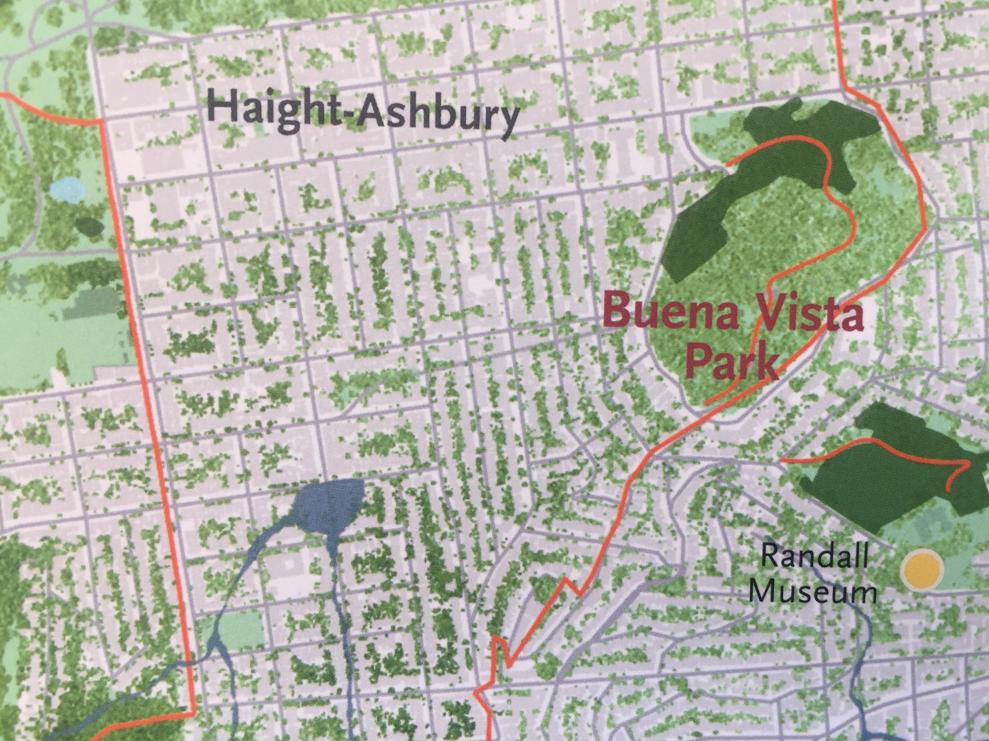

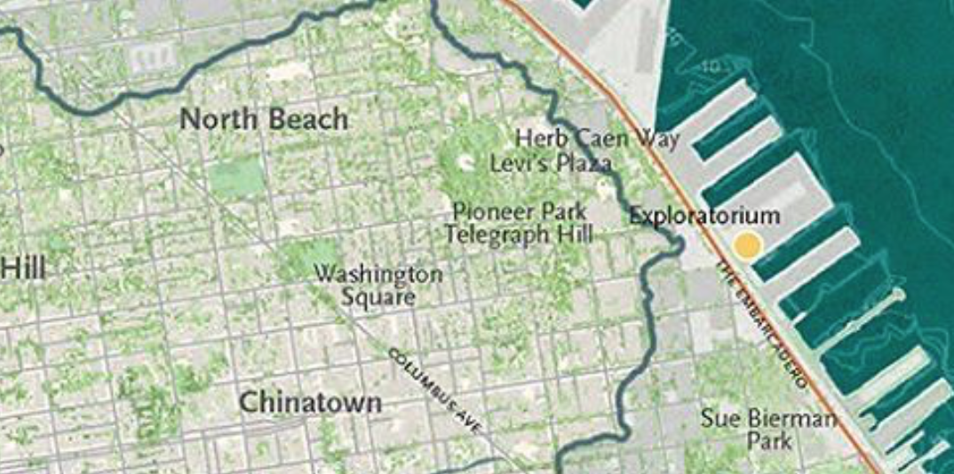
San Francisco, Greencover in Chinatown, North Beach, and Telegraph Hill, with old shoreline and bay
8. The pressing questions both maps pose for the future of the city recede before the different views they present of the place of nature in the city–and the arguments they make about urban space. For in questioning the city as a built structure, Nature in the City has long focussed readers’ attention on a complex of lived environments apart from built structures, from which residents benefit. The exclusive focus on paved physical plant of cities in most mapping tools leave us guilty of treating the limited descriptive parameters of map servers as if they constituted urban reality.
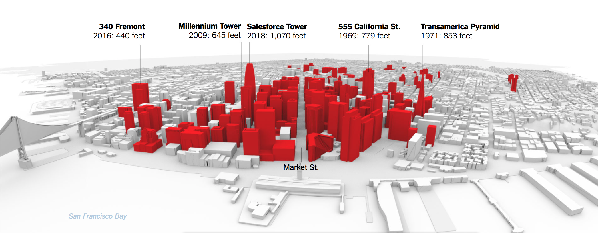
And in this sense, the map has arrived at an opportune time to shift attention from the hulking monoliths which San Francisco residents get their minds around, that seem destined to proliferate across a new skyline, in ways Fuller has repeatedly wrestled even as it has emerged in architectural renderings idealized for future buyers–
–as a real estate fantasy, dangerously out of touch with actual seismic risks. And by inviting structural engineers to question the ethics of seismic responses in building codes, calling attention to their limited protection codes for urban residents in what is the most densely trafficked regions of the city, and most occupied by workers (if mostly white collar). The interactive graphic of the appearance of such downtown mixed use buildings offered a chance to reflect on the effects of the 1906 earthquake and ask if such overbuilding inevitably suggested a sort of seismic trap.
The alarms that the built skyscrapers–without those planned–were cast clusters of danger signs in the scary prospective view of the city’s future ed buildings of assess the and an increasing debate over the final and future shape of urban space that invited readers to take stock of an apparent rush to build on shaky grounds.
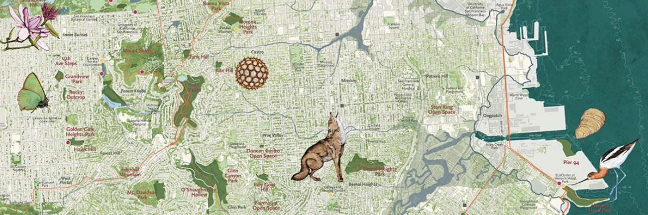
Is it any coincidence that rather than focussing on buildings, the team that assembled the most recent ecological map of San Francisco for Nature in the City map included not only a female cartographer, Lindsay Irving, and a team of naturalists to “experience dynamic nature in San Francisco” through the efforts of its lead writer, Mary Ellen Hannibal, and its designers Leah Elamin and the wonderful natural illustrator Jane Kim–to create a map designed to be deeply appreciative of the possibilities of interaction with its lived environment that focussed on the multiple possibilities of environmental stewardship, rather than the danger of elevations of building heights that the expansion of vertical projects of construction create. The sense of opportunities of stewardship of ecological conservation and habitat conservation create a web of possible stories of interacting with the complex urban environment for city-dwellers to appreciate stories about nature and tell them to themselves–in sharp contrast with one of impending doom–a collapse of buildings and towers that would literalize a veritable real estate crunch.
The view of built urban spaces opens a perspective on the city that is not shaped by the hegemony of real estate, or the real estate market, and an economy of scarce housing, but a colorful view shaped by a distinct agenda of nourishing urban habitats, outside the built spaces of the city which coexists with it. This distinct view affirms a concept of the “livability” of urban space, determined by data gathered independently from its booming real estate market or construction, is something of a new sort of urban enterprise zone–tied less to an economy of goods than of space. The inspired team of naturalist and innovative visualizers who worked to collect datasets from which they could design a map that engaged audiences in a new sense of urban space extends the historic efforts of its founder Peter Brastow–now Biodiversity Coordinator at SF Parks–to offer different ways of looking at urban space but invite the viewer to develop a different relation to the city that they though they knew. By mapping the contours of the urban environment by the green habitat that it offers against the spaces that they thought they knew well, and reorient them to the city that does not privilege built spaces. Did the distinct team they assembled help to create a view of the city less focussed on its upward extension, but on the sense of the city as a shifting set of borderlands to parks, ocean and migratory paths in which the city lies, nested among them.

The counter-cartography of the recent Nature in the City map offers a different lineage of mapping, shifting attention from the built structures to remind us that we risk filtering our actual experience of urban environments; for map servers, as much as lucre, also blind attention to an environment–or to spaces where we don’t drive–desensitizing ourselves to a delicate environmental balance, and masking the fluidity of habitats that cities include–the extent of open spaces in urban spaces that can nourish a broader ecosystem, even in a built space. So much was revealed by increased attention to the embodiment of urban space in the recent map of San Francisco by the Nature in the City team, winner of a 2017 Livable Cities Livability award, that devoted increasing attention to finding and describing the parameters and metrics for the livability of a future urban space. The emphasis on the encouragement of local habitats of native regional species in the city–and their dependence on the availability of water sources and green space–suggest a very different emphasis on the future of urban growth. Rather than map the intersection of the city with data layers of open space or green space–as have many maps, and as is a relatively easy if provocative GIS trick–the intersecting layers of green space and open space are shown to produce a rich range of habitats for species that the urban dweller can actually experience, perceive, seek, and find.
The future of urban space is surely rooted in its ability to be accommodate lived spaces that encourage habitat in the Nature in the City map. By tracking local species, the distinctive nature of the city as an active ecosystem suggest a degree of civilization that respects the quite distinctive natural character of its terrain. In ways as magical as movies as The Parrots of Telegraph Hill tracked the survival of a flock of exotic birds recently counted at three hundred, the map invites viewers to attend not to escaped pets or urban residents as raccoons, pigeons, or feral cats,

but the interwined tapestry of ecosystems that map how San Francisco offers a complex space of “natural” habitats. The inventive tools used to map its urban ecosystems incorporates a variety of mapping forms to remind us of deep currents in urban space, from the landfill or sandy grounds remaining under the downtown area to the unique habitat sandy beaches, green spaces, streets, urban forests, watersheds, and gardens, and recover a sense of its living corridors beyond what city parks allow. The result is both a broad historical perspective on its living record, that allows readers to engage its situation in a broader ecosystem and as a habitat, but a new model for looking at cities and their livability.
The unique base-map serves to track living habitats across the city, using overlays to combine a variety of mapping forms usually seen in isolation. By employing LiDAR orthoimagery of trees, shrubs and grasses across the unpaved areas of San Francisco, as a guide to help us follow the habitats that the greening of a city allows, far beyond an exclusive focus on its parks as in earlier editions. The revisionary nature of a base-map of urban vegetation help expose living habitats in the city by mapping forms, to show how the city as supports a diverse range of habitats we would rarely discover, but in which the living structures of the city might be best located and situated. Even if we use our old mapping habits to approach the below map of greenspace in San Francisco–and try to locate where we stand, whose houses we’ve visited, or lived in, or where we remember meeting someone or had fun, as if to try to correlate that experience with the density of green cover, in exploring the actual map we try to “map” those greenspaces into the range of habitat that the city also preserves and includes.

The density of the layers of open data that the map compressed–tracing the density of greenspace by its elevation and distribution, suggest an extremely sensitive register not only to situate but emplot animal and plant habitat in the city by the bay. The availability of significant open datasets for San Francisco reveal an intersection between avian and mammalian taxa with its watery habitat so delicately to make one almost forget its place at the edge of the continental shelf, but to map its abundance. The data rich nature of the map that almost is concealed in its pictorial elegance allows the readers to perform the sort of deep dive into localities that are foreign to most paper maps, indeed, and reflect the increasing skills of aggregating and distilling data in appealing visual forms, and indeed unpacking locality as a complexly variegated form.
The hope is to reorient ourselves to the city as a built environment, to think of it as a capacious space that makes room for the creatures that dwell around it–not urban animals, or foragers like raccoons, geese or pigeons, but historical dwellers of the land-sea continuum that San Francisco’s terrain was defined by, despite and notwithstanding the redefinition of the city as a space for building that was amplified by landfill. The playwright Tony Kushner evoked the city as a bucolic terrain of a promised land during the mid-1980s in Angels in America—the “undulating landscape lying under the threat of seismic risk,” where danger only lay only in unexpected underground faults. The conceit God abandoned the world left stage after the 1906 earthquake, due to the changes in human settlement of the globe, is almost returned to in the orchestration of a vast range of data on habitats and tree cover by folks at Nature in the City to create a map able that seems take stock of the deep patterns of urban environments still suggest its closest points of contact with the the divine. Indeed, the deep reading of the terrain that the Nature in the City cartographer offers to situate the intersection of nature with its urban infrastructure provides a new model to examine the presence of nature in the built world.


Pingback: The Built World | Musings on Maps