
7. The translation from map to territory assumes several layers of translation in the case of the Holy Land: from scriptures to map to territory, to the process of being recodified within a map. But the layer of translation as one moves from text to map to territory and back again sometimes opens something like a chasm of misreading or interpretation of the ways that a map conform (or actually maps onto) a land. The image of a land of memory had taken on particular cartographical concreteness by 1898–three years after Theodore Herzl called for the creation of a Jewish Homeland of Palestine–as the region filled by the borders of the Twelve Tribes. The twelve tribes of “Palestine,” in this late nineteenth-century American engraved map of considerable toponymical and topographical detail, shown below. The map showing “Palestine, After the Conquest” employs four-color conventions to map a contiguously defined sacred land around Jerusalem, as if assuming an entity earlier absent, by focussing on a dense network of cities, rivers, and mountains to give physical integrity to its division by Biblical tribes. This 1885 map, destined for American Sunday Schools, staked a surprisingly concrete relation to a lost land–presenting the territory after the conquest as both a scenario and a background for historical events. Did its makers presume a similar rhetorical intent?

The inclusion of a series of geographically situated “Battlefields of the Twelve Tribes” in this 1864 map of the same territory similarly lent credible tangibility to the Holy Land’s historical topography based on current surveying of the same landscape. Indeed, the transference of the results of actual surveys to a topography designed for sacred reading demands further investigation as an area of cultural history. The positioning of sites of ancient battles against this field of clear elevations, hillocks, rivers, the Dead Sea and other dense topographic realities created a sense of concreteness on the region. Indeed, they invested the map with a sense of strategic encounters in an actual lived terrain–in somewhat of a proxy for the hopes for territorial repossession of an actually remote sacred land.
Did such glorious four-color relief maps, published before the journalist Theodore Herzl called for the creation and foundation of a Jewish homeland in his 1896 Der Judenstaat, help to conjure the territory? By 1897, Herzl described the goals of Zionism as “to establish a homeland in Palestine [that was] secured under public law.” The idea gained resonance because the map had already concretized a claim to the territory and the “legally assured home in Palestine,” long before the the 1917 Balfour Declaration affirmed “the establishment in Palestine of a national homeland for the Jewish people.” It almost effectively transposed the sacred map into a legal precedent, mapping a mythical historical toponymy onto an actual territory in ways with which we continue to struggle and contend. Numerous counter-maps have been articulated to narrate the geographic displacements and renaming that occurred, re-asserting the complex narrative that was itself generated from the increasingly fraught relation between territory and map. By 1900, the concrete detail of sacred maps seems to have realized imaginary existence of the region with a concreteness in a recognized and recognizable image of lands settled by the Twelve Tribes as if it were their property.


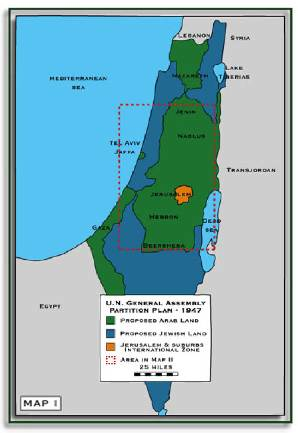
After 1948, negotiating these sites of settlement and creation of places of habitation was considerably more complex to negotiate, as the below map of Israel reveals. 8. For, to jump wildly–and perhaps a bit irresponsibly, it must be admitted–across time, Israel’s relation to the occupied territories shows a process of negotiation building from and negotiating lands, as much as the attempt to integrate Gaza or the West Bank in an earlier notion of a “Greater Israel.” This very broad chronological leap is meant to raise questions for clear rhetorical effect. For more pressing and compelling than the above cartographical fantasies is the holding power of the map as an image of the nation, and what a nation constitutes as something that is able to be mapped–questions that are evoked, here, by the manner that the image of land defined the bounds of settlement by 2007. It also suggests the deep tensions by which, in the end, as boundaries were increasingly drawn around the same land, the territory came to threaten to fall to pieces as the map was redrawn.

But to make such a leap is valuable, because it suggests the readiness to map the nation of Israel on a land that was, in fact, occupied, and the extent to which the historical-mythical construction of a place of clear boundaries is impossible to map onto a land that is inhabited. Indeed, the prospects for the two-state solution seem to rest on the abandonment of such mythical boundaries as the “Biblical Boundaries” associated with scriptures and Mosaic tradition, as sedimented as they are in a language of sovereign or monarchical rule–and the relatively clear confines of Palestinian people within the bright green areas is a radical expansion of the partition of 1947, when Jerusalem appeared a neutral orange; the since-defined confines are understandably not ready to be enshrined in print.
Moreover, the practice of “mapping Israel” was not only a practice of technologies of surveying, much recent research and documentation has shown. It was predicated upon the active displacement of its earlier residents. The destruction of Palestinian houses within occupied territories–according to data released by the Israeli Information Center for Human Rights in the Occupied Territories,” or B’Tselem, numbering some 4,170 Palestinian homes as of 2000, in a process that extended back to the beginning of those territories occupation in 1967. The homes of some 1,400 residences were demolished during the first two decades of the occupation after 1967; another 700 were destroyed by way of reprisal at the time during the four years of first “intifada,” and another 600 since then through 2004. (According to Middle East Watch, the only other country in the world to have demolished homes as a form of punishment was the Iraqi government of Saddam Hussein.)
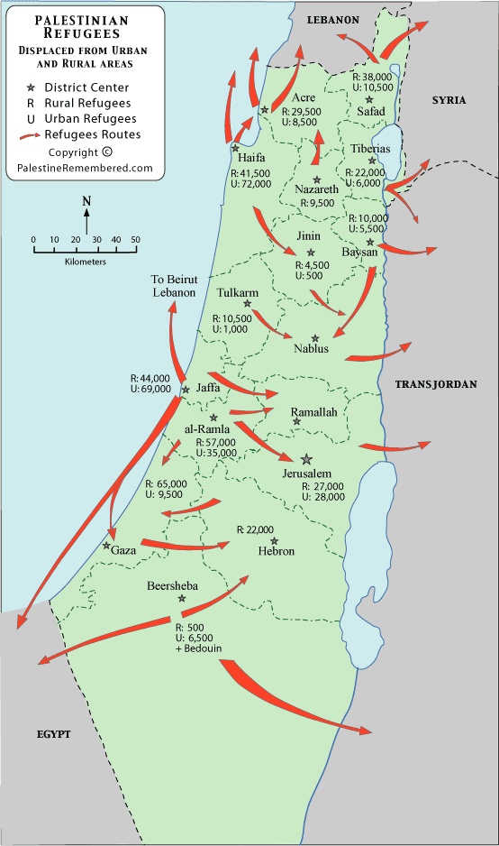
The stakes are high. Only after the March of Return to Independence Day of 2002 did agreement emerge to identify with Arabic names Palestinian villages that had existed in Israel before 1948, as well as their Hebrew names; many were taken by surprise by this strange proposal as late as 2000. The “other” side of the narrative of Israel’s settlement is presented in this 2012 map of the diminishing expanse of land occupied by Palestinians from 1897 up until the present. The below map cannot capture the human cost of displacement of some 5 million Palestinian refugees from the 1948 and 1967 wars and their descendants, now living in Jordan, Libya, and Syria, as well as the West Bank; it cannot adequately present the moment of the expulsion of Palestinian people from the former Palestine, still commemorated on May 15 as the Nakba Day [يوم الن], or the Day of Catastrophe, as a day of tragic loss of regional autonomy and land-ownership.
The map is striking for how it exposes a counter-example to the above fantasy of nation-building, however, that began from the passage of existing confines of the Balfour Declaration and 1917 Mandate for Palestine, or that the notion of a Jewish state in Palestine led to “the mapping of a homeland for the Jewish people” as Balfour had hoped–and the messiness with which “Palestine was reconstituted as the Home of the Jewish People,” in Rothschild’s words to Balfour. The expulsion of residents of Palestine paralleled a massive project, only recently reconstructed, of renaming of the land, and a government committee dedicated to the erasure of some thousands of Arab place names, from cities to hills, valleys and springs, was assigned the task of creating Hebrew names; David Ben-Gurion affirmed, “We are obliged to remove Arabic names for reasons of state,” dedicating the nation to the project of determining place-names in the Negev, or southern half of Israel. (The Bedouin who were asked to leave the Negev are omitted from the rural and urban refugees above.)
The Government Names Commission was established in 1951 in order to consolidate the nation’s identity. Indeed, by, creating a new national landscape that was distanced from Arabic names, extending the place of Hebrew toponyms across the map of Israel, Ben-Gurion government hoped not only to invite Jewish settlers, but to illustrate sovereignty. The project of naming places in ancient Hebrew when possible, despairing at the “foreign-ness of place-names, mostly Arabic, [that] exuded foreign spirit” actively sought to purify the land of Palestinian toponymy in 1951 and actively “to abolish foreign sounds and to enrich the map of the Negev with original names, close to the heart of the Hebrew defender of and settler in the Negev” (my italics); newly printed maps “purified of foreign names” confirm the identity of the Israeli state. Ben-Gurion–who effectively re-baptized himself in taking his Hebrew name from the medieval Jewish historian Joseph ben Gorion, instead of his given name David Grün, as an illustration of his Zionist passion: he similarly valued the aim of the commission as an ability to “to redeem the entire area of the Land of Israel from the rule of foreign language” in ways they concretely represented in maps. The “Hebraicization of Israel” was achieved by a “Hebraicization of the map”: the state promoted a project intended to “Judaize the map of Israel and to affix Hebrew names to all the geographical features of the map of Israel. Yet the costs and consequences of eliminating toponymy is poorly understood. To be sure, the interests of Palestinian residents are extrinsic to a deep historical commitment to restoring the recognizably Jewish historical geography through toponymy. From 1925 to 1951, Jewish memory provided a pool from which to draw Biblical or Talmudic place-names, such as Hebron or Jerusalem, conflating Jewish history and Zionist memory with the empiricism of geography from the time of the British Mandate. Maoz Azaryahu and Arnon Golan have found that over four hundred names of villages were altered and obliterated after the 1948 war.
This very process of renaming no doubt left scars or festering wounds as familiar sites were replaced by Hebrew toponyms, drawing from both the 174 toponyms that were mentioned in the Old Testament studied in late nineteenth-century historical geography. The degree to which Biblical studies itself came to provide a new Hebrew toponymy in not clear, and places often drew from Arabic place-names but modifying them in Hebrew to identify them with the Israeli state. The new map recognized by Jewish residents or settlers seemed to recognize and cement the traumatic loss of territorial land by inscribing it upon the surface of the map, to re-embody the Holy Land by cartographical tools and familiar place-names. By imposing Hebrew names of settlements on a 1942 British Mandatory Survey, this map on a scale of 1: 100,000 illustrates the transformation the region of the Negev on the surface of the printed map, as Azaryahu and Golan reveal an ardor of cartographical re-description and the resurrection of lost toponomy to recreate the landscape as it appeared on maps, and would be recognized by the state, absent of earlier inhabitants.


The creation of a new, Hebrew landscape on the topographical surveys that were crafted in Israel was intended to provide a “Hebrew map” for the general public, bleached of Arabic toponyms. As Azaryahu and Golan write, the Israeli government instructed the Ministry of Education from 1951 “to influence the schools, their teachers and pupils, to take upon themselves the task to uproot foreign names and to root the Hebrew names”– a metaphor linking the replanting of life within the desert lands to cultivating a national consciousness, and that was promulgated both by the military and on the radio in later years. By 1992, over 7,000 Hebrew names had been determined by the Commission “according to the geographical-historical truth of the Land of Israel,” as if it were by excavating the true meaning of the land and exorcising traces of any previous inhabitants. The perspective that is offered in any map must be recognized–for the perspective is one of reading territorial space and its actual inhabitation, both by bounding and, moreover, by narratively situating the boundaries that define the coherence of a territorial expanse. The narratives that are told in maps are particularly powerful, as Ben-Gurion realized, not only for “reasons of state,” but for orienting readers to a narrative of how they occupy expanse. The appeal to the map as precedent that has arisen after the Hebraicization of Israeli toponymy seems to seeks to establish a new common ground, revealing the narrative uses of maps as extending far beyond what they describe. The actual loss of land and contestation of the region’s territorial bounds has been not only commemorated but actively engaged by Palestinian authorities. Indeed, Palestinians hae created quite polemical counter-maps of the transformation of lands that the redrawn map, creating a sort of counter-commemoration of the Nakba–inverting the more familiar and triumphal narrative of the re-acquisition of the (lost) territory of the Jewish state by casting the nation’s growth as mirroring an erosion of Palestinian landholding in the Middle East. The below images maps an alternate narrative context for Israel’s accommodation to its boundaries:
The increasing rigidification of these boundaries–clearly drawn about the crucial toponyms of local habitation and control–reveals an ongoing process of territorialization, expressing the final culmination of the process that the Ministry of Education had set into motion back in 1951, on account of which an increasing number of narrative were tied to and wrapped around the map, reflecting the dramatic expansion within the levels cartographical literacy across the several generations since regional maps were introduced to schools as teaching aids. The process of territorialization drawn about increasingly rigidly demarcated boundary lines of frontiers in Israel itself was reflected in the below map of land concessions that provided a sort of inverse portrait of the Nakba over a restricted historical record: the relation of the mapped land to the place-names are omitted in this alternative map of attempted repatriation or historical compromise, but it presents an alternately wrenching narrative of sacrifice, itself evocative of narratives of its own; it aims to demonstrate the preservation of a united and still cohesive territorial space in times of increasing duress, as the expansive “greater Israel” imagined by right-wing parties contracted and were dramatically reduced from 1967–although it omits the dramatic territorial expansion that the 1967 connotes:

In beginning from the boundaries of 1967, the narrative created about the maps have shifted to the defense of boundaries, although the boundaries of pre-’67 Israel are clearly delineated within its cobalt blue. The tables of territoriality seem to have been turned again–and the rhetoric of mapping gained the upper hand–in a powerful a cartographical translation of the figurative archipelago of Palestinian settlements recognized by Israel on the West Bank into a nautical chart. It can almost be said that in the negotiation for new jurisdictional bounds of the Palestinian Authority. For as much as a map of territorial unity, territory lies in something like shreds.
Those territories cobbled together and granted autonomy at the Oslo accords remain raise the question of what map could be drawn about regions where they were granted varying degrees of autonomy in a coherent manner–and the implicit fragmentation that such degrees of concessions of autonomy creates. Julien Bousac made the point when he mapped the territories as an archipelago or an early modern island-book–or perhaps evocative of the fantasy maps of Robert Louis Stevenson–to question what sort of lands were actually surrendered or sovereignty granted in the “name of peace.” In mapping Palestinian sovereignty as a landlocked archipelago registers the unsatisfactory results of the process rather than actual distances or proximities, by providing its viewers with a literal reminder of the extent to which such a compromise over territoriality implies a cartographical dismembering of the two-state solution:

Le Monde diplomatique/Julien Bousac
The pointedly polemical nature of Bousac’s map charts the deeply compromised nature of the coherence that the Palestinian Authority holds in the very regions where it was conceded authority in the Oslo Accords, and the level of fragmentation that the Accords instantiate across the territory. Despite multiple proposals that have been entertained indifferent cartographical renderings of a two-state solution, Bousac’s 2009 map registered his apprehension of the process already in place to accelerate the fragmentation of existing territories by zoning produced by the Oslo accords. For his map suggests a fragmentation and denaturing of the very idea of territorial unity–the zoning would have limited communication among Palestinian territories. Indeed, their autonomy would be overseen by surveillance at Israeli checkpoints, and which would effectively permanently divide Gaza Strip from the West Bank into two states and allow only limited restricted internal communication among them. Bousac’s map reveals an imaginary archipelago where none exists of questionable viability as a state.

