Tag Archives: sacred topography

Clipping Bears Ears

The recent demotion of Bears Ears and the Grand Staircase-Escalante as national monuments pose risk of a deepening widespread and almost inevitable alienation from public lands.  The tenuous status of public lands was apparent in the mandate of protection after intense lobbying of the American Petroleum Institute and other players in the energy industry to cut the limits of National Monuments across the United States, in ways that stand to redefined American West.  And even as our so-called President touts his relation to the common people, apart from the political class, the removal of protected status from national monuments suggests a proprietary relation to public lands at odds with the longstanding protection of monuments. The Trump administration’s hasty decision to remove Bears Ears from the list of protected lands suggests an abandonment of that image of the heroic cowboy, replaced by the disillusioned world-weary post-industrialist capitalist character we seem to have as American President.

Rather, they conjur the image of the identification with the legends of the white man in the open space of the American west’s sun-drenched outdoors, whose landscape was open to the grit of white, male conquest of an empty space.

Trump and Wayne in western backdrop.jpg

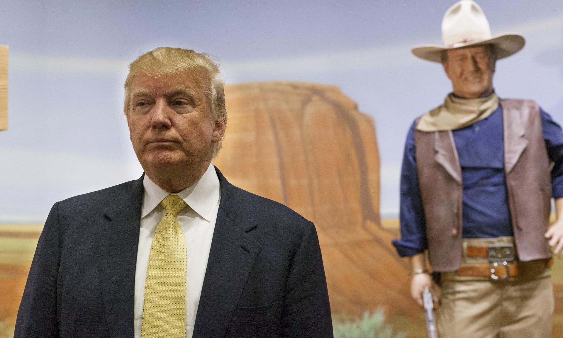
For Trump has definitively moved away from that imaginary, and the image of the open frontier, or of this land is your land, this land is my land, into a vision where the very same land is now poised to be opened to mineral extraction and prospecting, reducing the area once identified with the West to an area defined by the priority of industrial claims, and transforming it to a terrain inviting the colonization by extractive industries.  With his pursed lips, and evasive eyes, turning his back on a monumental landscape of the West, President Trump appears oblivious the destruction of space to occur across the national monuments opened to prospective mining, extraction of resources, and mineral industries, as if to deny their history, and allow the big rigs of extractive industries to enter to repossess those areas they have claimed on the map.

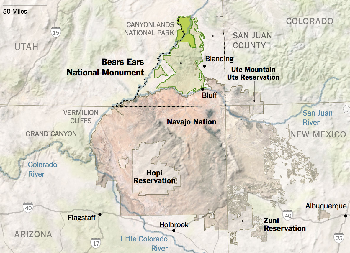
The preservation of a national monument that would rejoin fragmentary Indian Lands, indeed, was the strategic scope of the declaration of the two regions as part of our protected national heritage, in an attentive to remove previously protected lands from mineral prospecting in southern Utah, with the aim to improving the local economy and attract investment to the state now represented by Mike Lee and Orrin Hatch, who have both advocated the proposal to open the region to prospectors, with far less concern for its future of the country–responding to heavy lobbying by uranium mining company Energy Fuels Resources, which provoked a widely criticized Interior Department review, Trump issued executive orders that shrunk the monument to newly reduced boundaries.  For Hatch, eagerly labeling the designation of the national monuments as “unjustified federal land grabs,” evoking the increasingly militant anti-federal lands movement, particularly strong in Utah, who act as if the government had hidden interests in staking claims to a territories form wildlife refuges, conservation areas, national parks, or national monuments, summons a misguided anti-government credo as a basis for ending public lands.

Protection of National Monument of Bears Ears would expand claims to native lands in Southern Utah/Joe Burgess for New York Times

In replacing a sense of “goods” for the nation worthy of protection by the federal government–the purpose of the Antiquities Act of 1906, which expanded executive ability to conserve areas for preservation of their historical or scientific interest–to a vision of the executive asfacilitating abilities for exploitation of national space, and ensuring energy extraction.

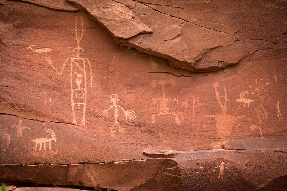
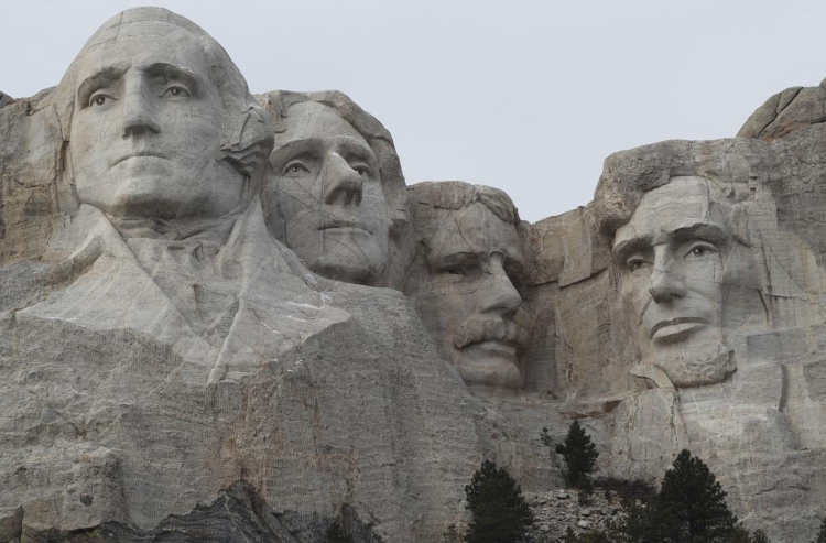
The result is to threaten fragile material evidence of the region’s prehistoric inhabitation in a site recently put off-limits to oil and gas exploration on account of its use value to extractive industries, contesting the inherent value of preserving an area that has been considered among the most “endangered” historical sites in America. There is a well known precedent of prospectors seizing the sacred grounds of the Lakota Sioux native peoples, that were in fact ceded to them by the United States government in 1868, in the Black Hils of South Dakota, to create out of the former sacred site that became the National Park of Mt. Rushmore, after gold deposits were found underground, leading to a renegotiation attempt that led to a massive slaughter of hundreds of women and children, until the national monument of Mt. Rushmore confirmed the imperial acquisition of the land, by engraving iconic images of past Presidents on the Black Hills to affirm its incorporation into the nation’s body, with five faces of United States Presidents presiding in regal fashion over the region by sculpting their faces out of the Black Hills where GEn. Custer had defeated the valiant defensive acts of Sioux Sitting Bull and Crazy Horse:

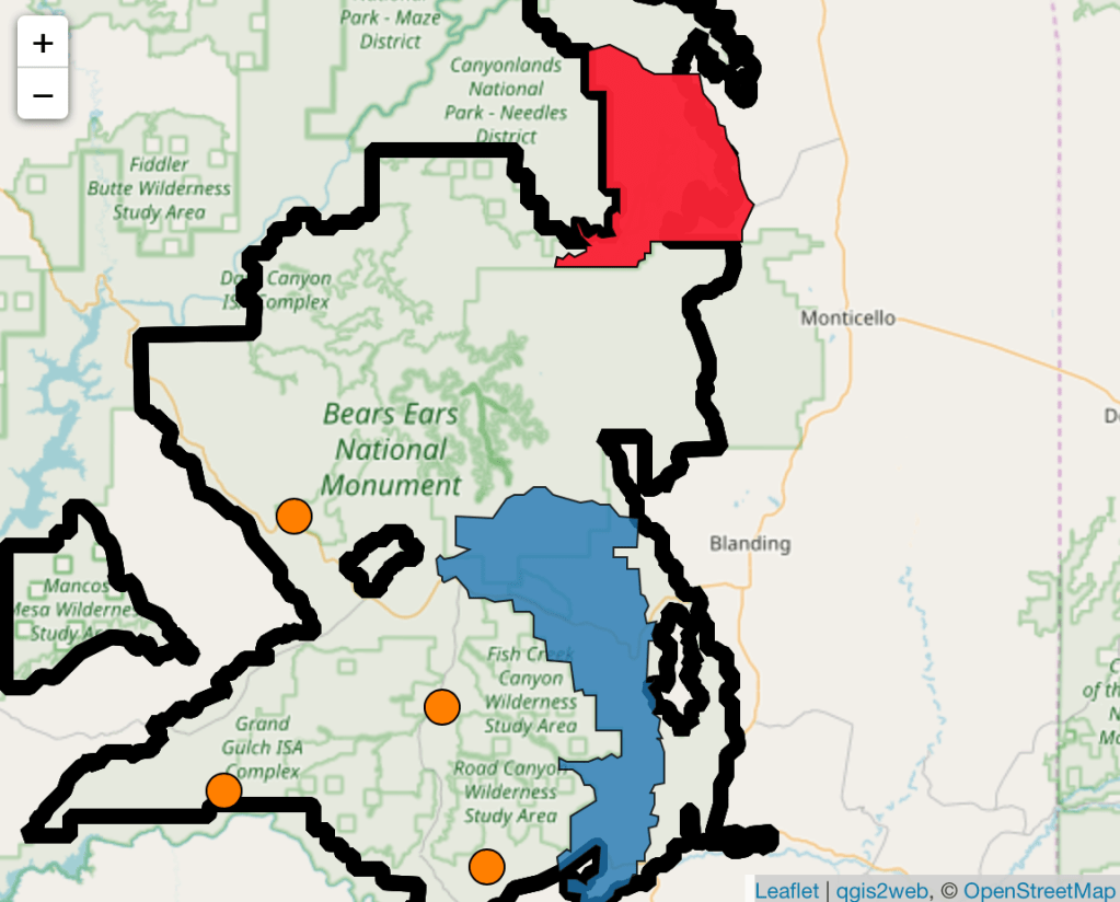
If the same logic of prospecting has caused the National Monument of Bears Ears to be reduced to a rump, to allow extractive industries with ties to the current President to erode the Presidential Declaration of his predecessor, the point-based logic of GPS maps of underground reserves has determined a new perimeter to be drawn, reducing the size of the monument to allow rapid extraction and export of oil and other fossil fuels on rigs, to accommodate the request of oil and gas company requests to drill in the monument that have been advocated from 2013, allowing access to over 100,000 acres of land, often filled by sacred ruins, within a mile or inside of the declared eastern boundary of the National Monument, that stand to attract increased road traffic, vehicles, and workers in close proximity to the eighty-eight parcels of national lands that President Trump seeks to auction off–setting a terrifying precedent for privatizing public lands, and for privileging commercial interests regarding sites deemed of value without consideration for the landscape that lies above them.

Expresssed Aeas of Interests for Oil and Gas Drilling in Bears Ears National Monument\\

After a long and intense attempt to resolve inclusively an accord with the Inter-Tribal Council of areas that were deemed too sacred to be sacrificed for commercial interests, no matter their economic benefit, that led many native lands to be affirmed as a National Monument, the rewriting of the map of national priorities with which Donald Trump entered office has led to a wholesale revision of the map of protected lands, and the rewriting of federal land management and protection, as well as the power of the Antiquities Act to accommodate lands deemed of unique in their historical interest for the country, by economic criteria, rather than historic worth.

image.png
Continue reading

2 Comments

Filed under American West, Bears Ears, environmental preservation, federal land protection, national monuments

Sacred Toponymy Matters: the Territory in the Map

In very few cases are the associations of place-names so powerfully resonant as in those that derive from a biblical frame of reference:  they speak across time, in a powerfully incantatory way, unveiling a sense of space in maps, and claims to that spatial jurisdiction.  Palestinians ruefully note that Jews–or Israelis—live in ruins, the myth of their past inhabitation inhabits the present through place-names on a map, and on a scribal map, as it were, that underlies the most sophisticated GPS claims to boundaries: if geopolitical boundaries are determined by hexadecimal coordinates of GPS in current treaties, textbook maps in the Israeli courses of Civics frame the territories won in the 1967 Six-Day War as a historical geography of liberation of lands in the West Bank that fulfill “a return to Judea and Samaria, areas where our patriarchs and matriarchs lived” and “where the Kingdom of David and Solomon was established.” The regions are identified as physical loci of collective memory, and indeed invested with elevated status as places to almost sublime transcendence of contemporary politics as constituting “the heart of the Jewish people,” more than contested lands. Such textbooks that instruct readers that “already in the Bible period, Jews lived in this area, and the Bible . . . this is where the patriarchs and matriarchs were buried,” evoking the lands and boundaries Jews gained as a people set forth in the Book of Numbers not as modern, but confirmation of expansion of the nation’s borders concluding a sacred narrative of the establishment of Biblical era, rather even if it is inhabited by Palestinians.

Such maps fulfill especially pernicious ends in failing to orient Israeli students to the world in which they live. One can find “Judea” and “Samaria” in books of Genesis and Joshua point to the Jewish presence in the region–although I first heard them referred to as places in the current world was when I moved into a condominium in Los Angeles’ Fairfax district, and was told by my neighbor Clara Markowicz that her husband was born in Judea, coming home with cans of goods she requested as I heard, in the stairway, of a region I had to ask as Israeli friend to clarify after I had brought her several bags of groceries in a gesture of neighborliness. The region had a concreteness in her mind as a birthplace, of almost mythic stature; the foundation of settlements that were often military outposts that became residential rapidly expanded as they were established after a pioneering rabbi founded a local yeshiva that seeded the settlement in the collective imaginary on a scriptural foundation that would later gain sovereign status within the rapidly changing arial map of “Israel” as a nation.

Local toponymy is rarely so transparently or so powerfully painted on a cartographical canvas to evoke of narratives of collective memory as in maps of the Holy Land, designed to orient readers to a sacred space, as much as within a territory–and to confirm the elision between past and present by the magical condensation of space that cartographic conventions allow. Although many of the best-known maps of the regions are reconstructions, the location of holy sites as Jerusalem, Bethlehem, Jericho, Caeserea or Mt. Sinai create points of entrance, more powerfully than siting points, for plotting multiple master-narratives across a historical gulf and spanning different epochs; the map is alternately the container and the field, the historical synthesis, but also the screen: Israeli annexation of 40% of the West Bank anticipates how a Trump plan would “turn temporary occupation into permanent occupation” over the land God told Moses would “fall to [the people of Israel] for an inheritance . . . in its full extent” in Numbers 34:2-3, as bounded by the “edge of the Salt Sea on the East.”  

The “conceptual map” for “Peace to Prosperity” a vision that Trump issued is proclaimed the “ultimate deal” ensuring sovereign unity of Israel, but proposed a very, very old idea of sovereign boundary lines. It was perhaps encouraged by his own love of borders, the plan pacified evangelical Christians who arrived to be volunteers in settlements and envisioned these new boundaries. Numbers 34:1-10 idealize the very boundaries of Canaan the Lord descibed “as an inheritance” extending to the Dead Sea –“up to the Salt Sea on the East“–as Israel’s territory only expanded to its full extent to the north in the time of King David, rabbis realized Pro-Israel evangelicals, skilled in the territorial visualization and eschatology, deferred questions of residents, wondering at living beside folk not sharing faith and lifestyle in the Holy Land–as strategic allies over the long term. If President Trump would be able to mimic the God-granted boundaries in his “vision” of the State of Israel that annexes land far beyond the current security barrier, and demilitarizes the West Bank by annexing some 40% outright, the sovereign expansion to include all settlements whose legality in international law has been intensely debated for over fifty years, but often reassessed “in light of new realities on the ground.”

The redrawing of the settlements on occupied land would be included in the “greater map” of Israel proposed, which demands interpretation against the deeper symbolic map sketched in Biblical pronouncements, rather than being defined by the new authority of GPS coordinates in international law:

Vision for Peace: Conceptual Map, January 28 2020

The power of such potent toponymy mark place by offering access to a sacred space, in ways that illustrate the dual deictic functions all maps have of showing or making present and of conjuring narratives.  So evocative is the verbal map of the region in scriptures that the map they help to weave and any later maps that respond to this image create a place where time collapses–where the present is poised to dissolve into the past. Current plan s for Israeli annexation of the West Bank in July 2020, given the green light by the Trump administration and the dauphin Jared Kushner, absorbing areas control by the Palestinian Authority and annexing areas all the way to the River Jordan, absorb regions now militarily ruled by Israel with a semblance or presence of local autonomy–“belligerent occupation” denotes more of a stalemate than peaceful accord–uniting areas populated by Israeli settlers into a single territorial unity and sovereign identity.

In one sense, the new announcement of annexation was a map of annexation issued by the Israeli government. But if the Netanyahu government announced it, the winking go-ahead was already announced in the “conceptual map” unveiled in Washington, D.C. by Trump January 28, 2020, by a U.S. President still in denial about reports he had received about the threat of a global pandemic emerging at brisk rates in China, already detected by the week previous by public health agencies in the United States, related to travel from China.

Can the characterization of this geopolitical map of expanded boundaries as a “vision” conceal the pandering to evangelical audiences of promoting a newly expanded Israeli territory? The deception of the map as a “vision of peace” echoed visionary maps of the Holy Land, long dear to evangelicals, as if to curry wishes of American Evangelical communities, and the hurried announcement seemed to solidify the map’s borders in the public imaginary, before the pandemic spread. The map that unifies the state of Israel with the Gaza Strip and West Bank, integrating the new infrastructure of an underground tunnel running between the West Bank and the Gaza Strip, seemed to suggest ready access from Beersheba to the Dead Sea, without having to pass through checkpoints,–and incorporate what were long deemed illegal redouts of “Israeli enclave communities” to a united and harmonious geopolitical unit, relegating the entire idea of a divided Jerusalem to the remote past, beneath the feet of Walter Benjamin’s Angel of History, and enshrining a non-contiguous Palestine: the prominence of these “new towns” on the map, in exchange for a freeze in future settlements–reversing a longstanding American opposition to West Bank settlements by a single map of new toponyms in the Samarian mountains, as Har Barakha, consolidated from Palestinian villages.

Vision for Peace Conceptual Map (detail)

The powerful biblical narrative of inheritance is so imbricated with the political map, so self-consciously entangled are map and text, or sacred toponym and physical space. Perhaps only a map can create such an entangled union that is presented as objective, or trick the viewer to read entanglement as objectivity. If the Old Testament discussed military maps, administrative maps, and historical maps, these were written, instead of drawn.  Reading the Pentateuch or New Testament extends an invitation to organize an image of regional coherence absent in the Hebrew or Christian Bible, however, and in a society where maps were increasingly familiar medium of information, they offered a powerful poetic and increasingly a polemic means to create a palpable present for readers of scriptures even when they were–or perhaps especially because they were–both physically and geographically removed from the region and the very space that they described, but preserved in a different space of the book, and through it into the very different register of collective consciousness.

Maps drawn of Palestine and of biblical history combine the ostensive functions of displaying place (showing) with the connotative functions of map signs to make present a landscape that was perhaps never seen as such:  in so doing, they show readers where they might be, and offer a map that corresponds to their reading of sacred narrative, and indeed of giving enargaic power to that narrative in the present.  But they are most powerful examples of a form of “distanced reading,” around which one can weave multiple narratives about the territory, or narratives of pilgrimage and sacred visitation, without necessarily going there and visiting the very sites that the maps situate before the viewer.  For the particular power of maps of the Holy Land lies in how they offer the possibility for a reader to enter the narratives as much as they provide a description of space.  When the most familiar verbal map of Canaan–“from Dan to Ber-sheba” (2 Sam. 24:2)–created a very loosely defined region, it allowed viewers to enter the specific sites it described.  Drawn maps served to frame the pilgrimage across and intellectual inhabitation of a region and emplot specific events for viewers who become, even when physically removed from the region, vicarious witnesses to an always-present Holy Land.

Continue reading

Leave a comment

Filed under biblical maps, historical maps, Holy Land, Israel, sacred territory