
The coloration of a slightly later version of 1589 highlighted how local qualitative detail functioned to communicate a more concrete or immediate–enargaeic–notion of place to its readers, in which they might voyage as both map-readers and observers, and suggests the rapidly increased levels of map-reading and interpretation among Ortelius’ audience.

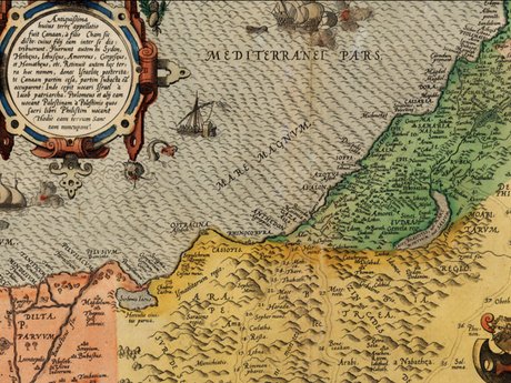
The Dutch map bound the regions by mountains, as biblical precedent described, and did not derive its authority from citation or footnotes, but presented an impressively coherent arrangement of toponymy against the field of a richly defined landscape, combining the density of its coast with a richly populated interior–and provided a model for defining and demarcating fixed regions of the Holy Land. Part of the deeply humanistic function of the Ortelian map, which made it such a monument, was to create a legibility of the Holy Land, instantiating the regions of “Israhel,” “Judeae,” and “Arabic Israel” in the historical map printed in conjunction with his early atlas, embodying that legibility unlike the Christocentric tradition of medieval mapping. The map created a concrete cognitive relation to a region removed from readers’ experience, exploiting its properties for demarcating expanse and noting place.

Such a relationship could not have been conceived in earlier epochs in similar terms. Widely reprinted in the sixteenth and seventeenth centuries, and commands significant prices on EBay, even in its reprinted versions, the written density of the map was originally crafted as a vehicle both for exploring a region removed both in time and space; the map wove coherence among places most often occupied in the mind, and served as the basis for Ortelius in 1570 to map the Itinerary of St. Paul round the Mediterranean–in a map included in Ortelius’ comprehensive collection of maps, the Theatrum Orbis Terrarum, to stake the historical unity of the Mediterranean region more cogently than had ever been articulated or expressed. The particularly detailed toponymical density of Ortelius’ 1570 map of the Holy Land reflect intense interest in assigning these places a tangible form, and a deeply humanistic sensitivity to preserving a register of place and region able to be mentally and cognitively occupied that invested a transparency in the map’s surface, as it naturalized the spiritual landscape. The image had religious and cultural implications for the artifice of map making:
Ortelius’ map created something of a precedent for the legibility of later maps of the Holy Land. As much as it offered a projection of terrestrial continuity, the map itself served as a field of projection, on which a viewer’s relation to the region that it described could be written in ways that its authoritative form lent a new level of credibility and materiality as a cartographic document. If all maps are ‘arguments,’ the mapping of sacred space around Jerusalem, from the space occupied by the Twelve Tribes to the itinerary of St. Paul, presented vehicles and media for collapsing time and forging an affective relation with “space” across different cartographical standards and competencies. The space of the Holy Land was mapped and re-mapped as if to affirm its existence as a space of redemption–a space of redemption by whose mapping you could affirm yourself as also redeemed, and whose readers could affirm themselves, by being vicarious witnesses to the continued presence of a Holy Land, redeemed. In a land haunted by many ghosts, multiple narratives link to its powerfully evocative toponymy.
Perhaps the strangest part of any map of the “Holy Land” lies in the intense play between the distance and proximity of how it is imagined: hence, no doubt, the compulsion to remap the area, and to wrestle for its identity. Those who first mapped the Holy Land in Europe did so to preserve an image of the far-off land for future generations–men like the church father Eusebius, or his follower Orosius, or the monk Honorius of Autun, reconstituted place-names as a form of reading space in a tradition of “imago mundi” popular among early members of the church. Their written geographies created set a basis for translating narratives into a map by which to imagine greater proximity to a distant sacred land. Early manuscript maps that accompany their texts set a basis both for locating specific places in the broader canvas that a map offers for weaving them into a cohesive territory. The function of mapping grew as a practice of preparing a legible field for the translation of toponyms, and preparing a surface that could be readily read and that existed to be internalized. Rather than being only associated with a religious age of scholastics, consultation of the map as a vehicle of redemption have continued to inform a contemporary search for spaces of redemption, even as they offered a reassuring view of the world for earlier readers of the Bible or Christian monks.
2. As much as telling their readers where they were, maps of the Holy Land had long earlier oriented viewers to the continued occupation of sacred space. For the contents of such map, whether either symbolic in nature or naturalistic in their construction, holding something of a contract and promise for the continued inhabitation of that space both in the medieval period and through modern worlds. This post hopes to place the investment of importance and the historical resonance of place-names in these maps to understand the debates of mapping toponyms and indeed mapping the settlement and continued territoriality of modern Israel against such a broader canvas, where place-names have an ability to summon up not only a sacred narrative, but, in neo-Biblical terms, a land that was unlike and distinct from other nations, and places whose historically sacred nature defined their relations to specific people. One of the greatest barriers that existed in the premodern world was not only geographical, but between human and divine. Indeed, the practice of medieval mapping might be understood as reconciling the divine and human eye, as Denis Cosgrove argued, by mapping a divine perspective in terms men could understand.
Medieval maps of the Holy Land listed place names with few orienting guides, but seemed to promise to traverse geographical distances, allowing a sort of imaginary travel not only across space–as Cassiodorus was quick to tell his monastic followers of Christ–but also across time. The map provided a reassuring model of reading the toponyms mentioned in the Bible, even when, as this extract of the Holy Land from an encyclopedic world map of c. 1110, probably executed by Henry of Mainz from a geographic encyclopedia, they derived from lists of place-names whose classification is removed from a coherent territorial record. Rather than assembling a coherent description of space that provided a base-map, Henry of Mainz’s map ordered toponyms that referenced other sources and narratives to offer a reassuring relation of the relations among the sacred city of Jerusalem, Bethlehem, land of Judah, the sea of Galilee, and Antioch in relationship to the Mediterranean–Hellespont, Alexandria, Egypt and Libya–that could lend spatial coherence and concreteness to existing biblical passages, trigger stories, and lend them proximity. And already its regions were separately distinguished by clearly ruled lines.

Such manuscript world maps may evoke the barrier between human understanding and sacred history by noting sites associated with the story of Christ, such as Jerusalem. But these maps also allowed readers places to enter a parallel narrative structure of the Old Testament and other historical periods, framing the Kingdom of Judah, for example, the tribes of Asher, Dan, Benjamin, Simeon, Issachar, or Antioch in Syria, for the benefit of its readers. Did the map create the territory? While abstract in nature, during the time of the crusades, Jerusalem was a far more familiar place than it had previously been for Christians. Maps of the Holy Land and Palestine collapse time and space more immediately than other maps, instantiating categories as timeless, and often offering pleasure not only in their universal and encyclopedic scope but in their labelling of place: such sites as Mount Sinai, the Tower of Babel, Babylon, Jordan, Sumeria, the Dead Sea and Twelve Tribes offer entrances to familiar sacred narratives. Ruled lines divided the region along clearly drawn regions, which, unlike the undulating shore or the islands of Rhodes or Canopus, offer points of access to a narrative. Although the Sea of Galilee, Babylon, Damascus, Antioch, Tarsus and Nazareth, seem atomized to us, they allow readers to imagine a sense of proximity to narratives. Even if the form what appears discontinuous and schematic , and to not describe continuity in a meaningful frame of reference to modern eyes, the map offered a sense of crossing a boundary from profane to sacred space, inviting viewers to enter a sacred topography disclosed to privileged observers: it makes one consider the huge power for ordering space by lines in maps, as if to impose fictional divides on space in order to better process them.

The sort of concrete connections that maps might produce from individual narratives or sacred history existed as a conceptual space for its sacred readers that could be divided into plots–no doubt as if to better emplot places in an accurately mapped space. If the above map was drawn at the same time that the region gained new materiality and presence, as one that was visited by crusaders, it was removed from geopolitical bounds as we know them, and was never seen as a region by most of its intended readers. It creates, however, as all maps do, invitations to explore space, and to provide a way of telling its readers “You Are Here“–a particularly poignant invitation when it comes to the toponymy of a region drenched with sacred connotations and narratives, which served as keys to memory as much as points of orientation, and provided orientation to a sacred space, as much as the space medieval crusaders had sought to recapture. Yet the territorial unity clearly emerged from the map, if only from the verbal map of sovereignty that the Bible described.
For readers of these maps perhaps more than for others, they weren’t there, and the map was more of a marker of a site of existential importance more than being a place that they would ever actually stand in and occupy. In establishing the distance of readers from place, as much as opening it for them, the place-names opened a region where time collapses–the present poised to dissolve into the past for the foreseeable future.

