
With Manhattan long ago out pricing many who might have lived there in the past, even as New York City’s Mass Transit Authority does good duty as a serviceable means to secure transportation across the isle, the five boroughs are simply not fully linked to the surrounding extra-urban area residents are pressed to move. We needed Aaron Reiss to give voice to the less-mapped history of “paratransit-systems” fashioned from a web of dollar vans linking the city’s residents and constitute a central part of its perpetual mobility.
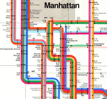
If New York City’s MTA map was a modernist icon of the city that initiated one to a labyrinthine pathways as a right of passage–the long-gone tokens are often worn as necklace, fetish, and a totem of conquering the web of transit–the map showed a preponderance of lines running north and south in Manhattan shortchanged commuters to Queens, and barely served Long Island.
The 1972 modernist remapping lent coherence to the historical layering of a system of subways, organizing its individual lines of the BMT, IRT and IND in a system of streamlined colors so its order seemed intuitively clear. Designed by the late honorary New Yorker Massimo Vignelli, whose graphical craft would rebrand much of New York City in the early 1970s, so indelible has the iconography become that its subsequent iterations continue to respect the constellation’s symbolic form. Reiss appropriated the same iconography and symbolic form to move beyond the service in five boroughs and suggest a system which operates where busses and subways just don’t reach, providing a guide to the routes on which large numbers of Manhattanites daily travel to destinations the city’s “public” transit system doesn’t extend or recognize.
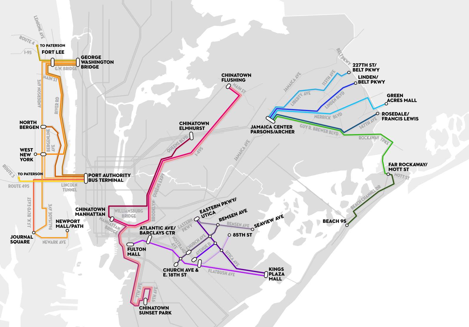
With the apparatus of MTA subway lines left in a ghostly grey that might indicate their supersession, Reiss provides the other map that is perhaps more present to a range of New York’s residents, collating commuter routes across low-income (and often immigrant) neighborhoods that supplement the system of subways run by private companies which offer far more than service to JFK. Working at lower cost than the system of public transit itself, these lines/shuttles, more often known about through employees and networks rather than from printed or paper maps, to render what Reiss calls “New York’s shadow transportation system,” and which he dignifies with an iconography imitating the elegant minimalism of Vignelli’s classic map.

Vignelli’s spider-like tracery of pastel lines improbably festooned a grim New York with candy-colored stripes spreads out from the dense knot of Midtown (Central Park is an improbable squat grey, alerting viewers to the map’s distortion and representational remove), a bow of ribbons from which it serves the outer boroughs.
The real story behind the map is the extent to which this vision of the transit system no longer serves the needs of a wide range of commuters, who have attached themselves to a system of public transit hubs to more easily move among the now-geographically-disparate pockets of ethnic communities by lines of dollar-vans, minibuses or limousines, often to reach places on routes of transit the MTA doesn’t offer–from which it has even, Reiss found, withdrawn as service has contracted. To be sure, the Vignelli map was importantly adjusted in later years, the sinuous routes prepared by graphic artist Nobuyuki Siraisi helped Michael Hertz and Associates design a more phenomenologically elegant version map of New York City subway lines, approaching the subway system in a new light by riding each line with eyes shut tried to capture the motion of cars along the tracks, the better to capture passengers’ embodied experience in his sketchbook; his sketches were used to render the routes of the trains might feel as a way to register their experience in the train–rather than against surface streets or a geometrically elegant symbolic form.
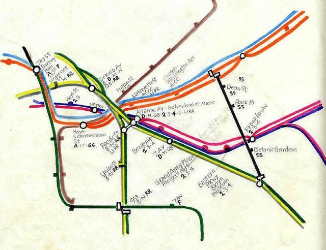
By riding the cars regularly to create the basis for the Herz map, Siraisi sought to try to resolve the discrepancies riders had expressed between the clean lines of the modernist map and their experience, foregrounding the sinuosity of subway lines to capture their paths, and render the lines by a color-scheme that translated easily into words–blue, green, red, grey, Kelly green, tan–to create a more universally accessible map, that other designers were able to complement by including above-ground markers of urban topography that riders would know, and using distinct fonts for parks, neighborhoods, streets and cultural monuments that fabricated a legible palimpsest of spatial registers.
But the different users of subways do not contain themselves to a single ride, and the intersections of subway lines and transit system are increasingly fragmented in a city where social homogeneity is a relic of the past. By providing culturally familiar settings of transit for work, links among ethic enclaves, beyond making trips to airports, cash-only van lines permitted by the New York City Taxi and Limousine Commission continue to serve the working-class underserved, offering an ethnography of immigrant populations in the five boroughs and New Jersey coast and malls in an unofficially improvised response to local needs. If needs are met in ways that arose from informal networks of drivers and dollar vans, Reiss did not imagine affirming these for users, but render a visual ethnography of the improvised economy of urban transit, The result is to offer map-readers a voyeuristic way to look at the emergent economy of dollar vans as if it were an autonomous system of transport of its own,–in ways one imagines would not be so happily welcomed or accepted by the majority of its drivers paying customers.
Reiss’s map more to the point shows the degree to which the aging public transit systems of Manhattan and New York City at large has found itself outstripped by the pressing needs of a larger populace. In ways that reveal the relocation of many immigrants to regions out of the purview or coverage of the existing public transit webs, the improvised sub-economies reflect the city’s shifting social geography, and offers, more than an actual guide to transit, something like a guide to the dispersion of formerly contiguous communities, and indeed often more recognizable (and less costly) modes of travel than the city’s underground subway lines. With the rise of fares for the subway, and inflexible nature of much of the physical plant of subway lines to keep up with the city’s expansion to outer boroughs, the lines provide quick lines of transit able to keep up with the geographical displacement of communities, as well as more culturally familiar modes of travel.
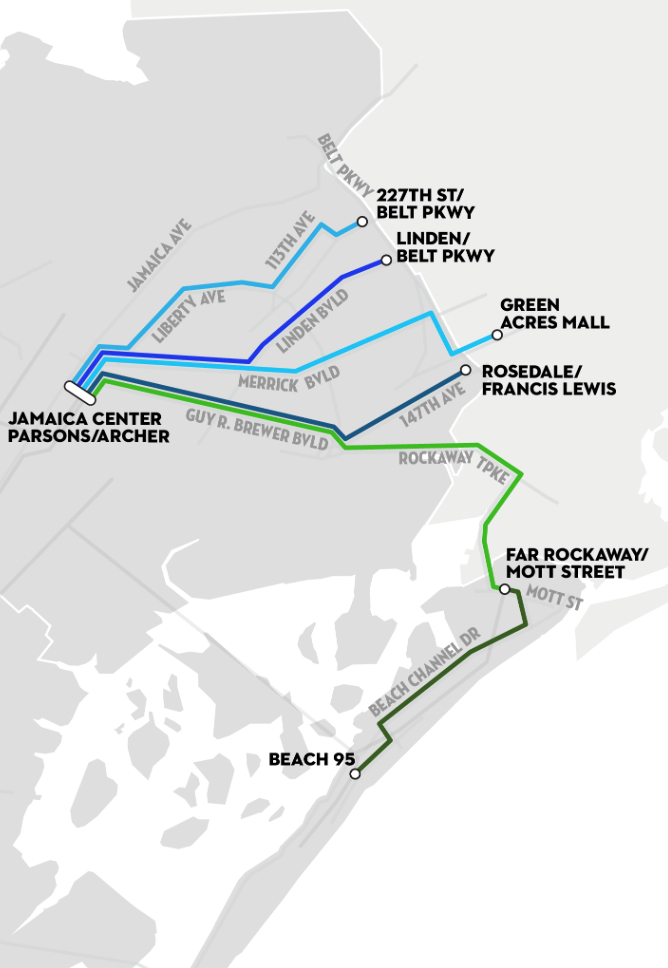
When you read the maps themselves, think less of an interlocking system, than a mode to link the removed, reflecting the subaltern cultures of transit from Jamaica Center to Long Island and Far Rockaway,
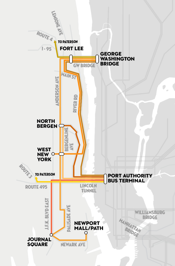
across to work in Eastern New Jersey from the Port Authority,
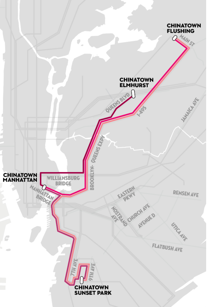
or among New York’s recent dispersed Chinatowns.
If Vignelli’s modernist map celebrated the antiquated system of transit was, in turn, widely celebrated for its untangling of the layers of public transit–adding a contemporary sheen to an outdated outfit and enlivening an apparently creaky enterprise–Reiss’s map untangles how communities have spun off the accepted grid.
His map recalls Pakistani-American artist Asma Ahmed Shikoh’s elegant 2006 appropriation of Vignelli’s subway lines to her neighborhood in Brooklyn as a cultural microcosm of the city’s expanse as a whole, converting the iconic map to an Urdu manuscript, the maps create a poetics of presence and reuse of urban space–albeit in ways that stretch beyond the circumscribed range of transit the system provided itself.
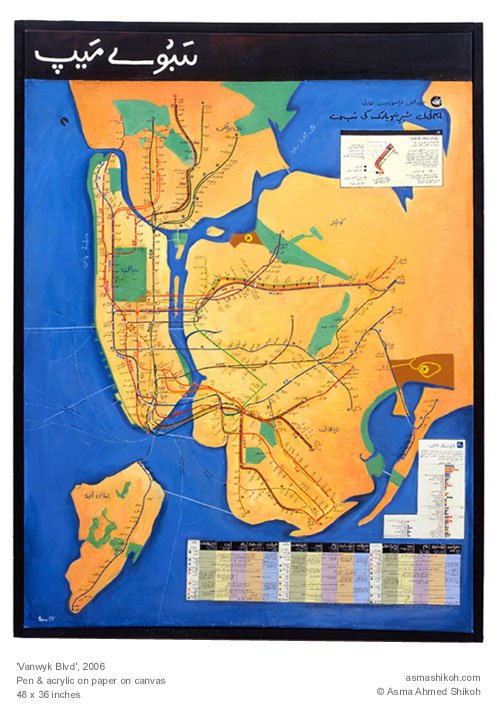
But if Shikoh deftly showed “Vanwyk Blvd” in a new iconography of her own community, returning the map to the tones of an illuminated manuscript to give it a scriptural status, Reiss uses Vignelli’s symbolic form to give graphic form to the process of dramatic disaggregation of the new New York City that a newly improvised system of dollar vans arose to meet.

