
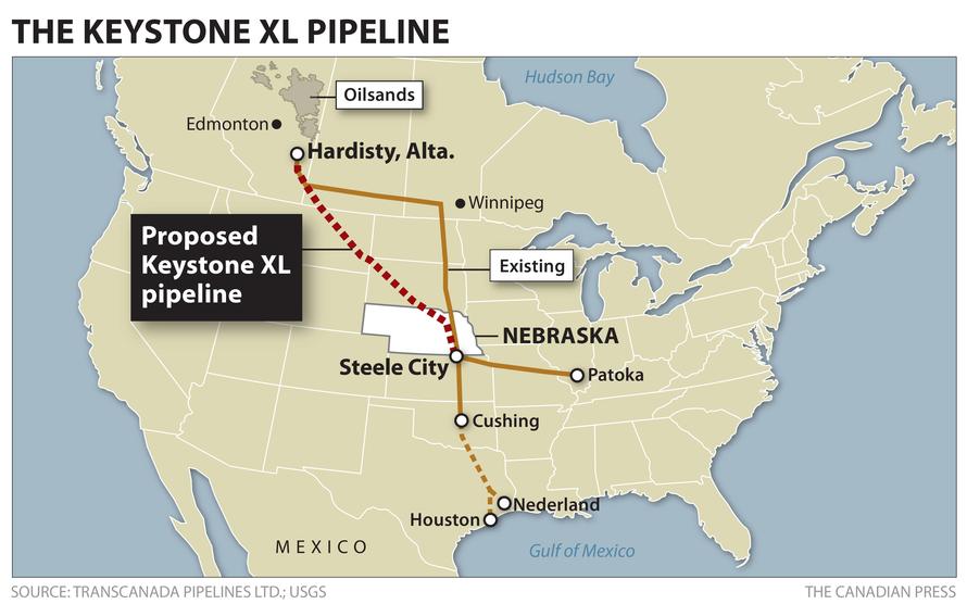
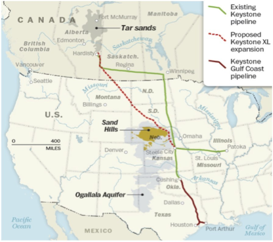
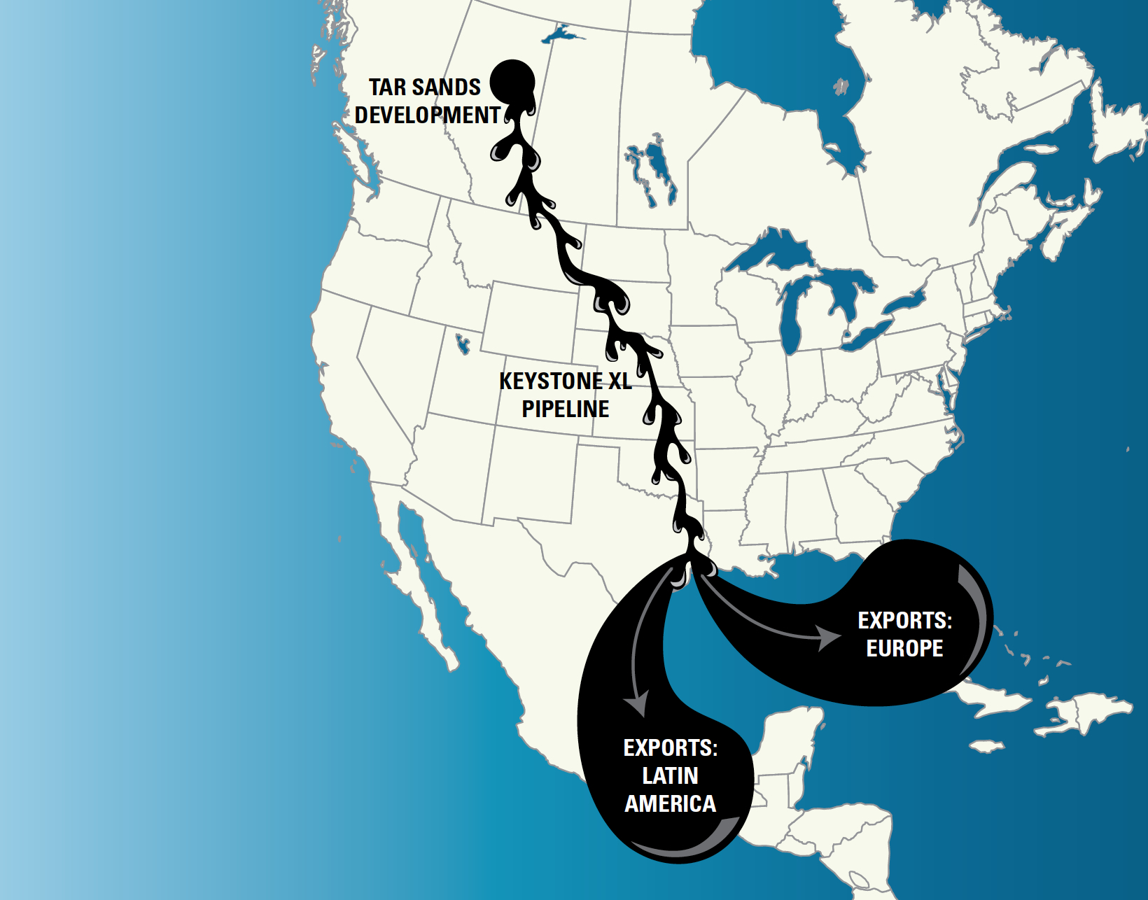
Last year the Senate failed to pass the bill to authorize the construction of the Keystone XL pipeline. But the fight was intensely waged before a map, and it seems time to scrutinize what that map charts, and place it beside what sort of future map of an energy landscape we seek to create. And as debate continues, and we look at maps to understand the potential transformation of the landscape the would result from the pipeline promising to carry 800,000 barrels of bitumen/day across farmlands in the central United States, running across many so-called “red states” of a Heartland, from North Dakota, South Dakota, Iowa, Nebraska, to Texas and Louisiana. The planned assembly of sections of this massive megaproject of overland pipe could at any point contaminate farmlands, native lands, and waterways to create massive public health risks. But we have trouble mapping such risks against a thirst for energy, and a demand for energy independence, to allow us to have access to gasoline for driving cars–even though this bitumen is refined–to petroleum products and to preserving the perpetual light blue incandescent glow of television screens.

Or are not prepared to do so. As we allow battles to be waged primarily I courts since a district court famously placed a permanent injunction on hopes for the pipeline’s construction in November 2018, leading the President we have to re-issue a new cross-border permit that sought to replace the previous permit issued by the State Department, under his sole authority as executive framer of the nation’s energy policy, even in the face of no plans for pipeline construction in 2019, we need to map both the benefits that the Keystone XL pipeline against the real risks it would pose. Indeed, the almost hubristic attempt to build pipeline from Hardisty all the way to Houston, in ways seems a straight line, suggests a huge amount of new pipeline that would challenge the technology we have of transporting bitumen, to provide crude for existing refineries in Houston and Galveston that falsely promises to restore their industries, even by raising risks we cannot start to fully imagine in an age of rising temperatures, increasing climate pollution, and the possibility of actual national emergencies. Even before Transcanada’s own maps, we should pause at the claimed promise of jobs and easy energy–
–especially in the face of clear alternatives, already under construction, by which the oil would be shipped for refining to Asia, at a rate that is far beyond the 800,000 barrels per day Keystone XL is designed to carry.

The transport of the messy, oily, Tar Sands bitumen and slick through the proposed expansion in the pipeline would, of course, cross not only farmlands and run relatively alongside of rivers that trained to the Gulf of Mexico, but transport petroleum through a region of the largest aquifers of the central United States, as well as raise threats of the possibility of leaks into above-ground streams and rivers, which would be difficult to clean up, not to mention 2500 groundwater wells lying near the proposed pipeline, whose monitoring for possible contamination would subtract even from any possible revenues that the pipeline would create.
But the specter of losing promised jobs, and indeed of a declining American petroindustry above-ground, long active in local and national politics, has made the fear of alternatives–and alternative energy exports from Canada–frightening to many United States Senators, even if the refineries in American waters or mainland would not be receiving the bulk of bitumen shipped from American ports, and hardly would keep them active alone.

And the recent decision to adopt measure designed to designate the built pipeline sections “critical infrastructure would criminalize any damage gas facilities currently under construction as third-degree felonies that can carry as many as ten years in prison, preventing “impair or interrupt” protests or even entrance into property with the intent to damage or disrupt to become recognized as felonies by the state of Texas–if not the second degree felonies that was proposed in an earlier bill proposed by Representative from Marshall, TX. Such bills are intended to disrupt any environmental protests against the 650-mile Jupiter oil pipeline and Kinder Morgan’s 430-mile natural gas Permian Highway pipeline, both designed to transport fuels above ground from one of the nation’s largest oil patches in West Texas to the Gulf Coast, with the intent to prevent protests of civil disobedience or environmental justice as has occurred in Standing Rock. Despite the danger of such pipelines to San Antonio’s drinking water, the rush of a boom in oil and gas production in the Permian Basin of West Texas, en rushing to build pipelines across the state despite tremendous opposition from landowners whose lands would be seized by Texas law that allows private, for-profit companies to claim rights of eminent domain: such anti-pipeline-protest legislation has been adopted in Oklahoma and Louisiana to stymie protests seen as unnecessarily disruptive, and have been overwhelmingly supported by the oil and gas industry who seek to secure their rights to construct pipelines, and cast any attempt to disrupt their construction as disruptive interfering with corporate operations, and probably disruptive the possibilities of protest of native nations as it would impose severe fines and penalties of up to $10,000.
And the recent decision to adopt measure designed to designate the built pipeline sections “critical infrastructure would criminalize any damage gas facilities currently under construction as third-degree felonies that can carry as many as ten years in prison, preventing “impair or interrupt” protests or even entrance into property with the intent to damage or disrupt to become recognized as felonies by the state of Texas–if not the second degree felonies that was proposed in an earlier bill proposed by Representative from Marshall, TX. Such bills are intended to disrupt any environmental protests against the 650-mile Jupiter oil pipeline and Kinder Morgan’s 430-mile natural gas Permian Highway pipeline, both designed to transport fuels above ground from one of the nation’s largest oil patches in West Texas to the Gulf Coast, with the intent to prevent protests of civil disobedience or environmental justice as has occurred in Standing Rock. Despite the danger of such pipelines to San Antonio’s drinking water, the rush of a boom in oil and gas production in the Permian Basin of West Texas, en rushing to build pipelines across the state despite tremendous opposition from landowners whose lands would be seized by Texas law that allows private, for-profit companies to claim rights of eminent domain: such anti-pipeline-protest legislation has been adopted in Oklahoma and Louisiana to stymie protests seen as unnecessarily disruptive, and have been widely
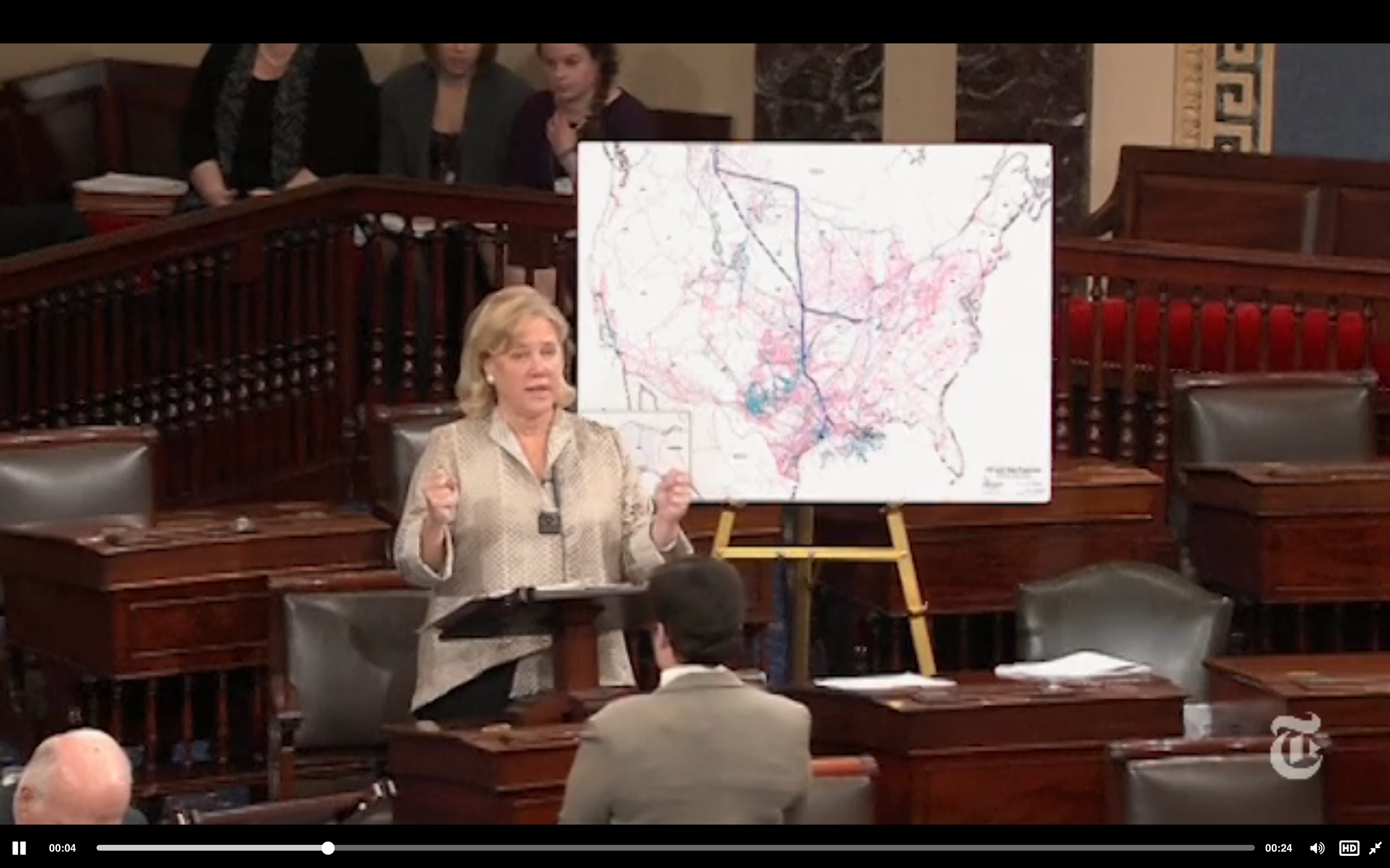
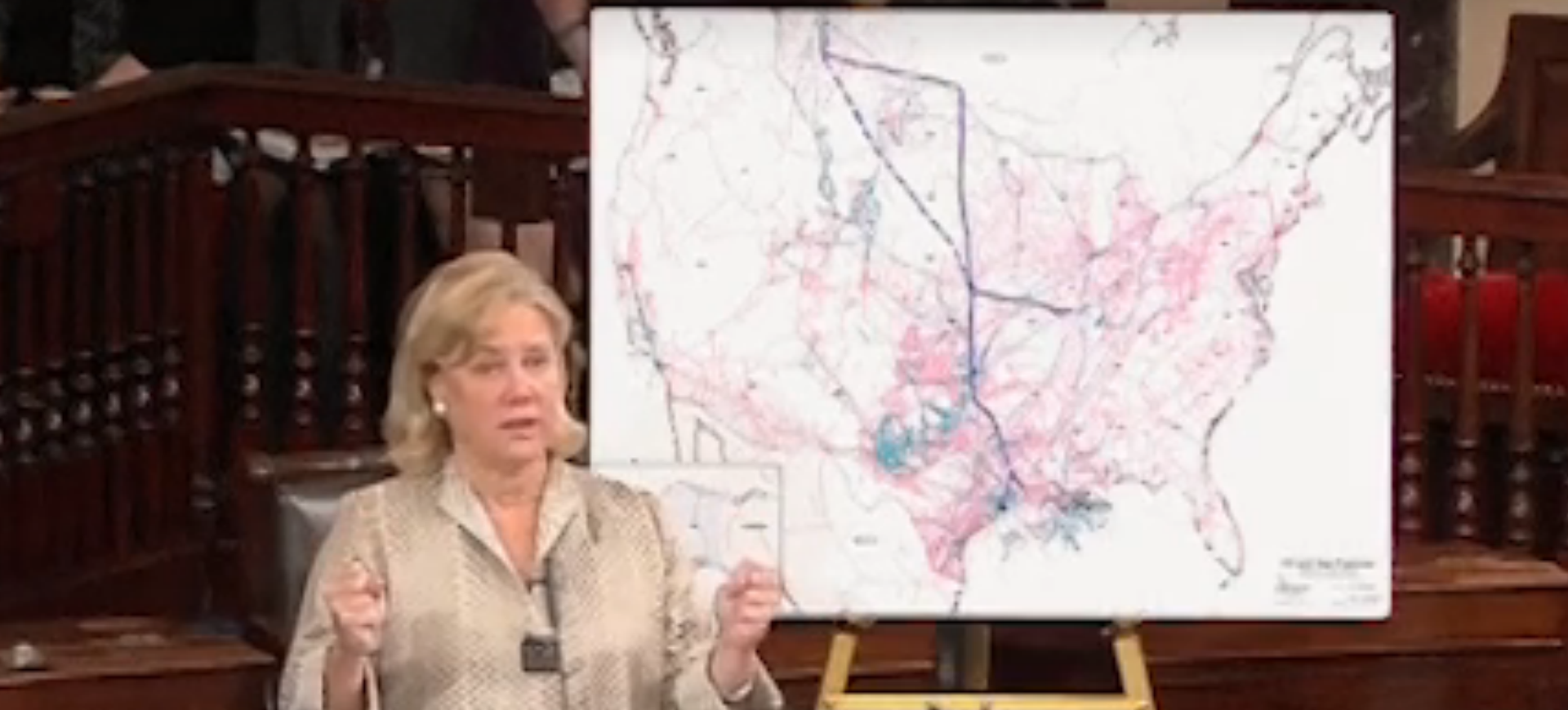
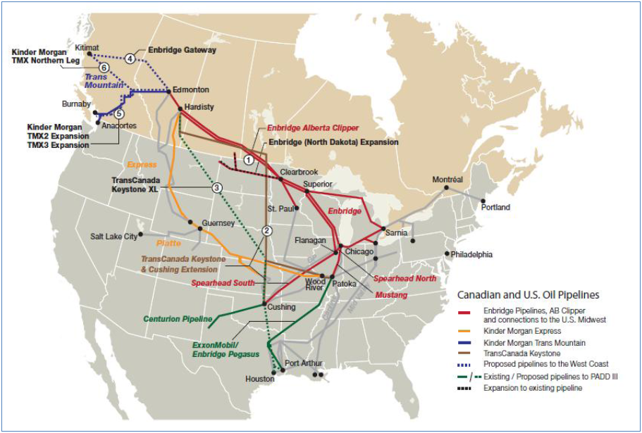
The debate about the pipeline was first rehearsed before a predominantly Democratic Congress, before 2014 elections led Republicans to promise to place the Keystone at the top of their Congressional agenda–in the attempt to place it on an actual map. The first effort to pass the bill was championed by a Democratic Senator from Louisiana, who vaunted the benefits it would bring to New Orleans and the Gulf of Mexico, and hoped to convince the C-SPAN public to the nation as a whole. At a time when the long-time senator felt increasingly politically isolated, Sen. Mary Landrieu (D-Louisiana) staged a photo-opportunity standing before a map of the nation: the map placed the proposed project for laying line across the US among a web of existing national pipelines, as if it would symbolize her own relation to the nation, as well as the place the pipeline within the much-vaunted promise of energy independence. The deceptiveness of the map by which she sought to symbolize such independence had of course been crafted by pro-corporate supporters of the pipeline, and its deceptiveness–and erasure of costs–needs to be examined, lest it be lodged in one’s mind.
For longtime Sen. Ladrieu, the map displayed the Keystone pipeline as a key to restore or burnish the image of America as an energy superpower. Yet it disguised the devastation of the extraction of oil or the fact that little of the oil transported was destined for or needed in an American market. At the same time as oil consumption is declining nationwide and prices are rapidly declining worldwide, Landrieu used the map as something of a backdrop to sell the pipeline by placing it at the centerpiece of a compelling, if largely illusory, vision of energy independence. But the declining significance of oil to US energy problems (or energy policy) was obscured by Landrieu’s appeal, as it will be, in the Republican priorities for the new Congress, as they make it a top energy priority and link it to the hope of “energy independence” again. Although such approval would have little effect on changing gasoline prices, and obscure that we face an oil glut, there is almost a fetishization of the pipeline as opening hope for an expansion both of offshore drilling for gas on public lands, and an acceleration of the permitting process for exploring for natural gas that have already been granted. Hortatory banner ads trumpet with urgency the enticing promise of “Leading America to Energy Independence”–and claim that that will all be done safely, with our best interests in mind.


Yet although the Keystone pipeline has become something of an entrée to the expansion of a new US gas and oil boom, and is billed by TransCanada as the “safest and most advanced” pipeline in the continent, which would offer a new “essential infrastructure” to American oil producers, despite a glut of cheap oil, by presenting the $8 billion project in a rhetoric of progress in energy policy–even though the 800,000 barrels of bitumen (or diluted bitumen) that it would promises to transport each day all the way from the Alberta tar pits to the Gulf Coast refineries would be destined for export, and would mean only 35 permanent jobs.
With no clear benefit to American consumers made clear, however, the “progress” of the bill is being pinned to the notion of creating an expanded and renovated energy infrastructure, even at the cost of expanding other serious infrastructural problems in the country. By integrating the network of existing gas and oil pipelines as a single network, the map used situated the delayed Keystone project as part of a national network of pipelines, suggesting that it would take its place within a coherent national energy policy.

Joshua Roberts/Reuters
Yet whether such an energy policy exists remains open to debate.
While the map provides a photo opportunity for describing a network that will return America to energy self-sufficiency–the national map becomes the framework to illustrate the collective pipelines that transport both gas and oil across the nation and from offshore wells, as if these manmade pipelines served as the arterial system that illustrated the nation’s vitality–the illusion of energy self-sufficiency masks the fact that, as the boom in Shale gas is poised to restore the nation’s status as a major energy producer for overseas markets, industry needs to augment or retrofit the existing infrastructure and terminals to be able to export oil and gas efficiently, of which the Keystone pipeline would be the test case. Indeed, as an infrastructure for exportation becomes an increasingly important part of the future plans of the energy industry, the map of pipelines may have become removed from the national energy market–even though TransCanada is building a separate 2,858-mile pipeline from Alberta to refineries in eastern Canada. But the danger of a possible leak or bursting of the pipes–even if they are vaunted to be the strongest yet–could create a spill of national devastation far greater than the recent oil spill in Montana, where the bursting of a twelve-inch steel pipeline (albeit a third of the thirty-six inch pipeline used in the 875 miles to be built in ten sections on a 110-foot-wide swath of land), has recently sent oil not only into local drinking water but dispersed contaminants that flowed downstream to a confluence with the Missouri River over sixty miles away in North Dakota–creating a state of emergency declared across several counties after residents found the drinking water to smell like diesel and be oily.
The actual relation of the pipeline to national energy markets would effectively be minimal. Even though the map foregrounded the impact of the Keystone pipeline on a national energy system, the plea for “independence” voiced by Mary Landrieu, but honed by operatives in the Republican party, would be to circumvent the current and longstanding ban on the crude oil exports from the United States, and effectively re-write energy policy by allowing the Keystone pipeline, despite its significant costs and potential risks, to provide precedent to change that ban. In addition, the Keystone pipeline would set precedent for effectively demoting the status of environmental concerns–and demoting the very fears of potentially dramatically raising carbon emissions in ways that that have been the basis for EPA actions aimed at cutting carbon emissions that have been enacted by President Obama in ways that have hamstrung the same energy industries from expanding coal production in the southern states.
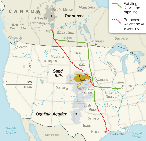
Yet the adverse environmental impact of extracting bitumen from the Tar Sands has already begun in ways that are also erased by the abstraction of the pipeline map that has been widely displayed as an image of Senator Landrieu instead hoped to place the proposal on President Obama’s desk was about illustrating her commitment to job creation. She barely concealed her longstanding support from the oil industry, however, which would be the benefactor of pumping oily bitumen across the nation to be refined on the Gulf Coast, together with Canadian oil companies. (The contested question of how much bitumen carried on the pipeline would remain in the United States is contested, and TransCanada has queried whether it makes any sense waited six years to pump crude to the United States to be refined on a 1,179 mile long pipeline: but the discovery of shale deposits and growth of fracking in the intervening years have led to the redefinition of original plans to send the Canadian crude to American markets; the decline of the arrival of crude suppliers to the Gulf Coast have also increased the demand to pump more oil to the region.) And after the bill failed to gain the necessary 60 votes to pass, a Lakota native American tribesman from South Dakota, the second of the six states through which the planned pipeline would snake, broke into song in the Senate chambers, as the Rosebud Sioux declared that the “fight against” the impending threat that its construction poses to the Ogallala aquifer had just begun.
New York Times
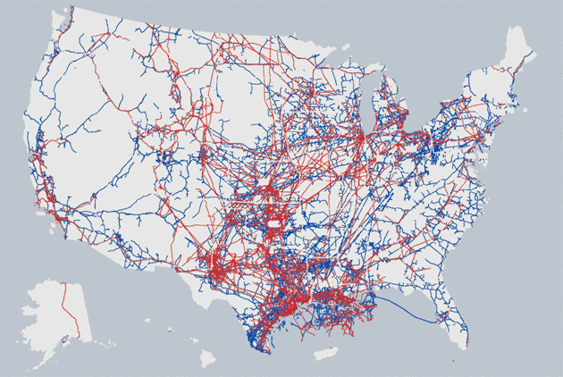
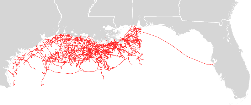
The map before which she stood appears based on maps that track the oil and gas pipelines that already carry gas and hazardous liquids through the country–a pipeline map–that tracks the range of lines across the country that currently exist, as if they were safe, although their own safety has yet to be ascertained. The complex of some 2.5 million miles of pipelines that stretch across the country is rarely, in itself, in public view, and has been plagued by actually serious incidents from 1986 that can be tracked on the following interactive map, assembled by ProPublica, based on regulators filed reports.
ProPublica
While the matrix of pipelines seems to suggest a healthy, functioning system that has posed little danger to Americans, one could argue that the reverse is in fact the case: the static version of this interactive map shows the wide range of accidents from ruptures to spills that have occurred over the past twenty years, plotting “accidents” that have occurred from 1986 to the present, or been labeled “significant” by regulators:
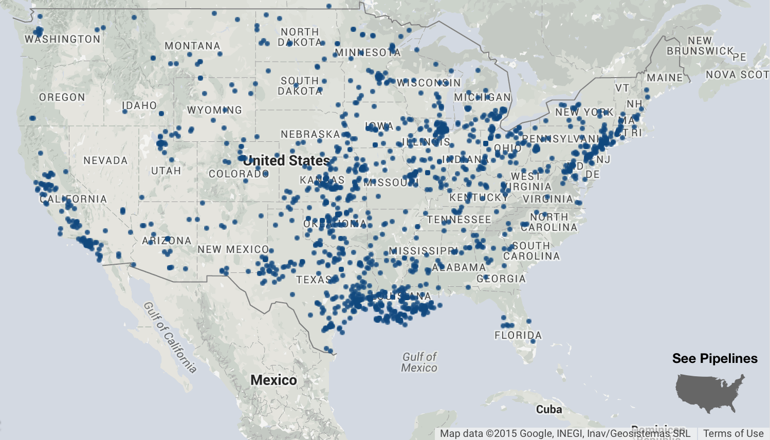
The spills have been blamed on corrosion of old pipe, for the most part, and distanced from the new pipelines that would comprise the Keystone XL. But as increasing quantities of oil are transported by train, as well as pipe it is important to consider that oil train spills have hit a record in 2014–more than any year since the federal government began recording data on spillages in 1975, loosing some 57,000 gallons of crude in some 141 “unintentional releases,” compared to just twenty-five a year on average between 1975 and 2012. This reflects that the federal Pipeline and Hazardous Materials Safety Administration acknowledges, that “More crude is being transported across the country than in any time in our history, and we are aggressively developing new safety standards to keep communities safe.” The picture, in short, seems that we have become committed to shipping more oil by train or pipeline–and if pipeline is not yet set, by train–and face increasing risks of oil spills in the future as a result. (It might make sense investing some of the $8 billion designated for the Keystone XL project on increasing the safety of such transport of crude oil across the country; while the prospect of 800,000 barrels a day that would arrive from the Tar Sands would not be compensated by the loss of a mere 60,000 gallons, the danger of the release of pollutants is steep; cleanups of ruptured pipelines such as the 2010 spillage into the Kalamazoo River approach $800 million.)
Moreover, the effects of “dilbit” that would be transported from the Tar Sands on pipelines that are planned to be laid from Alberta to the Texas Gulf has only been recently studied. Rather than weigh such issues and dangers, both Senator Landrieu and the pipeline’s supporters construct the debate about “independence”–a keyword that has been cunningly re-appropriated, and was being given new significance at this instance to inflect national debate. In ways that have intertwined the supporters of the construction of the Pipeline’s extension into the United States with American history and national character, the use of “independence” to discuss this international project is of course almost ironic: in the context of the multinational project, “independence” would be embedded in meeting the needs of a global market for petroleum and petroleum products, without any clear relation to the long-term reduction of the price of gasoline or cost of energy bills, and without any relation to the amounts of oil available to the national market–or the potential dangers of transporting energy across such a long stretch of underground aquifers and agricultural land.
“And when I mean energy independence,” Senator Landrieu firmly told the U.S. Senate, emphasizing a quite compelling if cunningly crafted keyword, “I mean energy independence for the North American continent,”hoping to muster the votes needed to pass Keystone XL before voters would decide her future in the Senate. The outgoing Secretary of the Energy Committee spoke before a map which displayed in detail the 2.5 million miles of pipelines across the United States as if they incarnated an established model of practice, and, by virtue of the superimposition of the Keystone upon them, realized her promise of energy independence. The gas and oil pipelines running across the map behind her illustrate the notion of the nation as self-sufficient she wanted to suggest: she often gestured to it as if it made good on the questionable promise of “energy independence” for the continent. Although President Obama’s claim that the pipeline allows “Canada to pump their oil, send it through our land, down to the Gulf, where it will be sold everywhere else” has been questioned, the oil would not simply enter the national free market.
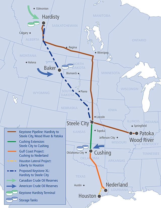
Senator Landrieu based her elusive promise of independence in laying the planned Keystone XL pipeline to transfer crude oil 3, 400 miles from Alberta to Port Arthur. But the diluted bitumen–“dilbit“–would not be destined for national consumption in the form of gasoline. It would rather enrich refiners and petroleum-based industries clustered along the eighty-mile stretch of the Mississippi between Baton Rouge and New Orleans–industries whose presence in that region of the sinuous waters of the Bayoux have impacted the region with grievous environmental degradation area, a previous post argued, mapping the toxic density of petroleum byproduct industries as well as refineries in land formerly lived on by share-croppers. Landrieu dedicated her attention to pushing for support of extending a pipeline that would extract, at great cost and environmental damages, oil trapped in the tar sands of Alberta to bring it to Port Arthur on the Gulf Coast, where it could be refined for export in some part, but the only jobs it might stand to create would be at ports.
To be sure, the issue is more complicated: there are multiple refineries that the proposed pipeline would pass, and the US has become a huge exporter of petroleum products from asphalt to jet fuel to gasoline, all of which could be increased by the consumption of more Canadian crude: the storage tanks of crude oil reserves along the proposed pipeline in Montana, Oklahoma are all near to refineries, and many refineries in Texas are in great demand of new crude, which the pipeline would no doubt provide–by carrying it from Alberta CA across the country.
But the plans for sending the bulk of bitumen to the Gulf Coast would allow the excess of oil products to be sent directly to the Gulf Coast: at present, Gulf Coast refineries already export one third of the oil they refine.
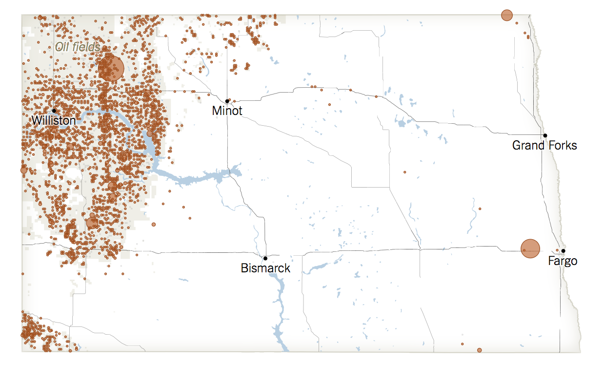
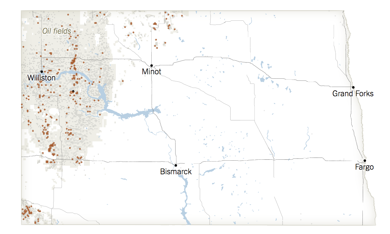
In presenting the senate chambers with a map of national pipelines, Senator Landrieu pointedly minimized the potential costs of a pipeline, mapped above by dotted red lines, and the potentials of leakages into the Ogallala Aquifer that feeds the Mississippi or the Nebraska Sand Hills, the second largest in the entire world, and normalize the importation of energy into the US. The map Landrieu propped up in the Senate chamber overlay the Keystone extension onto the nation as if it were an emblem “energy independence” in misleading ways. For if the map’s focus suggested that the oil would be destined for a national market, it just sought to normalize the pipeline within an existing web of laid line, downplaying its length. (This knowing use of a map reflects a political strategy first refined by Republicans seeking to stay on message and minimize the novelty of the Keystone line into current practices of energy transport across America.) Indeed, she erased the possible risks of the transport of such dilbit, despite the existence of a range of oil spills across one of the states that the planned pipeline would be designed to cross–North Dakota–where reported environmental incidents from existing oil wells from Jan 1, 2006 to October 13, 2014 were dangerously clustered around water sources–
of which those from oil pipelines were admittedly fewer, but by no means few:
Instead of portraying potential pipeline risks, the continuous terrestrial map conveyed an apparent seamlessness with oil would be brought to the Gulf Coast–in ways that would attract more refineries and petrochemical industries to the state, as well as much-needed jobs, seemed as elusive as its promise of energy “independence.” “What people in Louisiana want, what people in Texas want, what people in Mississippi want, what people in New Jersey want, what people in South Dakota and Illinois and Kansas and Vermont,” Landrieu argued in a quite overly broad geographic over-generalization of the states where work might be brought by the pipeline, “are good-paying jobs.” Yet the jobs would be primarily for transient short-term works, and bringing considerable long-term costs. While unemployment is high, the range of jobs that the XL pipeline brought with it would not change the 15.7% seasonally-adjusted unemployment rate for construction workers in the US, and would have minimal influence over folks in Vermont, New Jersey, and Mississippi, even if those Senators might be persuaded to support it.
And the question of its overall energy efficiency in this entire affair is unclear, although the degree that corporations would benefit from the transfer is–the costly overland transport of the oil would lead to an increased pollution from refining that would release 240 billion tons of carbon into the atmosphere. Lastly, the map concealed the potential future environmental damage created by leakages, especially into the Mississippi. And aside from illustrating the costly overland transport of still more oil to the refineries in her state, the notion that the diluted bitumen would be brought across the border to benefit the country by being refined in Louisiana for export, rather than the elusive goal of energy independence, which seems a red herring in this debate.
The promise of “energy independence” seems something of a sham, unless one somehow considers the needs for petroleum products meant for export as a pillar of our petroleum needs. However, the implication that the Keystone pipeline would primarily intersect with and augment the amount of oil, gas, or petroleum that flows through the nation–in a sort of “petrography” in which pipelines substitute for the waters that nourish the nation–is a convenient fabrication and association, not backed up by the facts.
New York Times
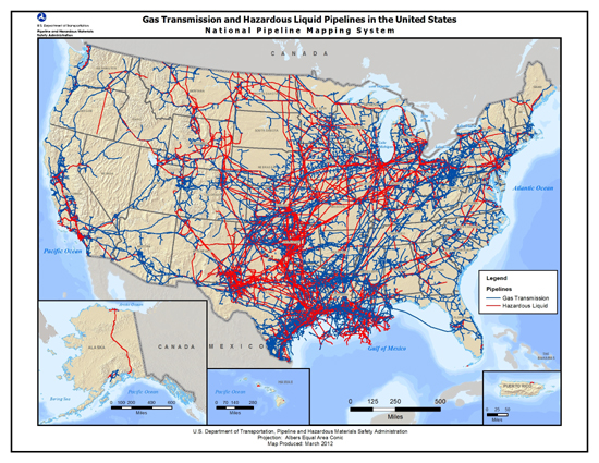
Lest one ever suppose the pipeline posed a compromise to Energy Policy or practice in the United States, Landrieu used a map prized by Republicans to make an effective case for the introduction of the TransCanada pipeline into the country, an image that had been pointedly designed to help “win the messaging war, as Republican Mick Mulvaney of South Carolina boasted at a recent gathering in Myrtle Beach, by showing existing pipelines across the country–he argued it revealed the dissonance between that “what the President wants you to see” about the pipeline’s dangers stands with existing pipeline used, as “often those two things are divorced in Washington, D.C.”–as if to suggest the distortions perpetuated by government. Larger distortions are offered in the map, which charts all energy pipelines in the U.S., entirely regardless of what sort of fuel they transport, let alone whether they carry oil or bitumen to a larger market.
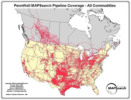
A two-tone version of the same map of 2012 distinguished the distinct networks of gas and oil pipeline, as a national system, untangles this dense web by distinguishing the overlay between each network of lain pipe.
But the largest geographical distortions of such maps however is to minimize where the oil is extracted, if its greatest distortion of benefits is to align the presence of bitumen in the Tar Sands with our national interests.
The network of pipelines misleads since it fails to note the volume of gas, oil or crude to be transported. The implied argument that it shows “pipelines all over this country that function each and every day without any environmental impact at all” is even more problematic. While it suggests that energy transport is already so strongly embedded in the infrastructure of the nation that the addition of one more could not change much, the map omits the practices of extraction that would allow this new pipeline to flow, and the costs and dangers implied by laying the pipe to carry so much crude oil across the United States–no extant pipelines indeed carry diluted bitumen, or cross large aquifers as the Keystone XL was planned to do, even if the extent of pipeline coverage reveals coordination between Canadian and U.S. energy corporations already in existence in 2002.
By superimposing the Keystone pipeline atop a similar map of both offshore and on-land pipelines, the map normalizes the laying of pipeline by placing it within the web of existing coverage, in order to encourage its acceptance. The map’s focus removes it from unique and specific costs–and indeed foregrounds the mass of situated pipelines as an existing network as if it would not be intrusive to existing energy policy. The greatest magic that the national map works for viewers is to subtract the costs of extracting bitumen up in Alberta. For as much as we’d like to regard the issue as about America, and American energy independence, it mask the interests actual the transport of oil would actually serve, and the local damages extraction inflicts. For the pipeline, by a magic turn of hand, relocating oil in a complex overland transfer, would be, it is promised, a form of economic rejuvenation of the old ports of the Gulf, which it would expand as a center for oil exportation. At a time when Canada’s pipelines are not even full, however, the decision to dramatically expand how much oil we pump across the country, and the diversion of diluted bitumen through the Keystone XL would primarily send new crude from the tar sands so that it could be refined in the Gulf Coast and shipped to all the world–to maximize the volumes Gulf Coast refineries already serve.
In an alternative mapping, that disposes with the iconography of pipelines altogether, the National Resources Defense Council provocatively mapped the dripping of a line of very viscous dilbit across the central United States. The map instead calls attention to the possibilities for leaks in any section of the pipeline; the leaching of dirty sands for export mapped below leaves the country in a clear visual echo of the disaster of the last Gulf Spill, when crude washed up on the Louisiana coast and so polluted its shores.
How many potential effects on the environment in Alberta are omitted by tracing only the routes of crude oil transport? Setting apart the dangers of potential leakages in the extended pipeline, the deep changes that this oddly construed geography of energy extraction are predicated on huge changes to the site where bitumen mining would occur, and large deposits of toxic sludge leaked daily into the Athabasca River harm not only its fish and Alberta’s boreal forest–and expose local residents to considerable carcinogenic risk that mining raises. Indeed, even if TransCanada pursues, as is expected, a network of railways to export the oil, to take advantage of its abilities to monetize its large supplies of crude, the costs of extracting crude from the sands–as well as the environmental costs of refinement–demand to be considered in this labyrinthine debate. And this is without considering the potential future costs of the leakages on the pipeline, the danger of which has encouraged Oceti Sakowin, the Great Sioux Nation, to gather with Bold Nebraska, and 350.org to respond to what Lakota have seen as a potential “act of war” against the earth.
Todd Korol/Reuters
Norm Betts/Bloomberg
The map of the projected path of the pipeline into the United States abstracts its costs. It masks of the curiously inefficient practices of moving extracted viscous deposits of the peanut-butter thick bitumen from Alberta to be transported south in the pipeline. The process of extraction poses huge environmental degradation to a region located in the boreal forest; extraction releases such greenhouse gas emissions from plumes of smoke so rich in carbon that Canada was forced to withdraw front the 1997 Kyoto Accord to lower standards, finding that its emissions have risen some 17% in the twenty years since the Accord was signed, although the Canadian government has so far strongly resisted adopting a carbon tax to try to discourage the emissions advocated by ShellCanada and Exxon Mobil’s local affiliates. (The first assessment by the Obama administration withheld opinion about whether the pipeline would worsen climate change, as well.)
But the huge amount of dilbit aimed to be transported would lead to the extraction and release of some 240 billion tons of carbon into the atmosphere that would, if it does not remain in the ground, be sufficient to raise the world’s temperature by a full degree. The costs of such creation of carbon, which would be evident in the risings sea-level and destruction of the shores, are oddly absent from any map of the pipeline’s proposed construction.
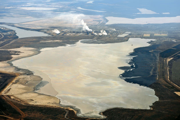
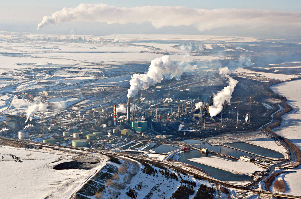
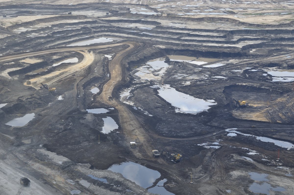
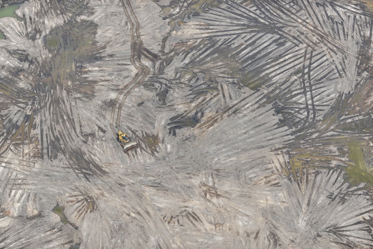
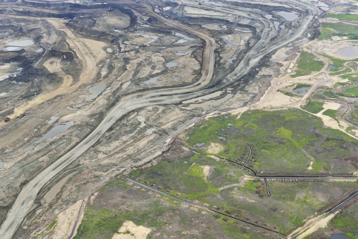
The evidence of such emissions are apparent, in part, however, in the environmental effects of carbon emissions and sludge pit creation that have occurred already in Alberta–a place not on several pipeline maps or not visible in detail, although the effects are written on the land. Such environmental effects are indeed often omitted and rarely represented cartographically, but have been documented in detail in the aerial photos of Canadian aerial photographer Louis Helbig, now collected in his book, Beautiful Destruction. Some of the costs of the environmental catastrophe located in Alberta are revealed in Helbig’s gloriously terrifying aerial photos, which capture the environmental costs of the mining of bitumen and its refining to crude on the local environment, or what is left of a landscape created to produce 345,000 barrels of bitumen per day–one fifth of which would be derived by extracting bitumen from the sands in a version of strip-mining, and have already altered the landscape where oil has begun to be extracted from the Tar Sands.
Even before the oil needs to be extracted from the sand and bitumen, it has to be mined:
Louis Helbig
One starts, however, from the clear-cutting of the region to begin the laborious and uneconomical process of extraction, removing all trees, plants, or other vegetation from the ground where bitumen lies–all of which is generically termed by engineers the “overburden”–to start to mine the potentially desired bitumen.
Louis Helbig
Louis Helbig
The bulldozing of such earthworks is only the start of a process which occurs after the bitumen is extracted–at the cost of a huge amount of water–and energy–and refined in ways that releases more byproducts of its own in the McMurray Formation, whose large “tar ponds” inflict untold damage–even before the oil enters the planned pipeline–on the surrounding environment, so that it is sacrificed for the goal of oil export.
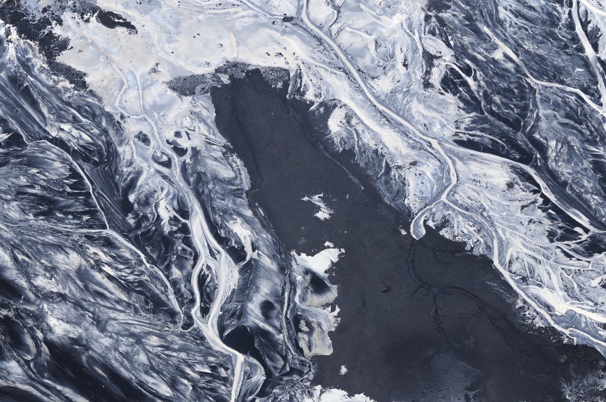
Once the bitumen is “refined,” waste-products deadly to wildlife are “stored,” improbably, in outdoor ponds.
Louis Helbig
All of this is what Senator Mary Landrieu doesn’t want you to see, but it suggests the costs omitted from a map. Indeed, these costs are omitted from the web of pipelines and planned expansions across the country, and the new risks raised by creating a pipeline through country where none exists for good reason.
Senator Landrieu think she is doing good service to Louisiana by bringing more crude oil to be refined on its shores. After all, the network of lines submerged off the shore has already created a coast actually crisscrossed by offshore pipelines, as permitted by the aptly named Submerged Lands Act which allows the Federal government to permit running lines on the ocean floor more than three miles offshore, creating the multiple sites of oil extraction like the Deepwater Horizon we all know so well.
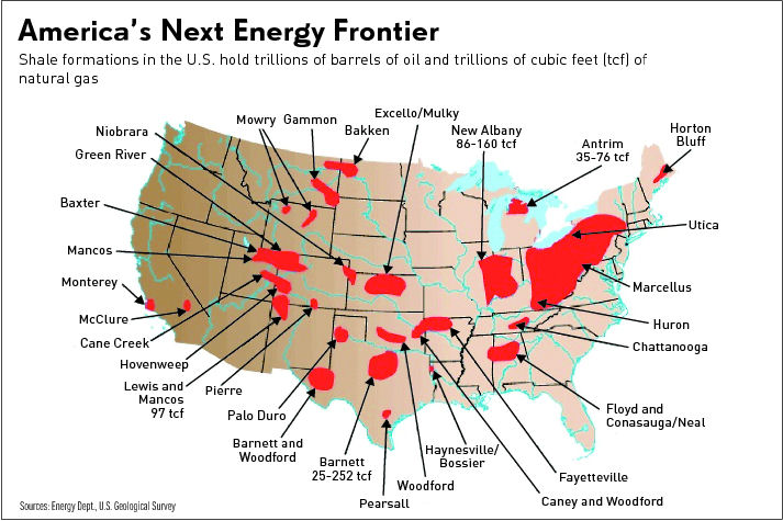
Did the map simply stop serving as an effective tool to envision what energy independence would look like? Of course, the fight against the pipeline’s construction is by no means over, and will probably be reintroduced in January, when the new Congress reconvenes, in another form. (Henry Waxman, the lone Democrat on the House of Representative’s Energy and Commerce committee to find it “seriously flawed” will no longer hold a seat as of January, although both Ron Wyden and Barbara Boxer remain “very concerned.”) But energy independence may look different now to many, with the arrival of new maps of the exploitation of the potential trillions of barrels of oil that are held in shale formations under many regions of the United States, and the considerable potential which many energy companies are no doubt eager to throw money at.
Even so, it must be remembered that a range of pipelines that promise to deliver tar sands oil across some 10,000 miles that promises to deliver some 3.1 million barrels of crude a day to global markets have already been projected for some time, and may indeed soon arrive.

Perhaps the most unspoken “map” that still demands a good cartographer to plot out is the amount of monies that TransCanada and other oil and gas industries have filtered to those republican politicians who represent state with the strongest presence of the energy industry, raising questions of where the best forum truly is to pronounce upon the future construction of pipelines at such incredible environmental costs.
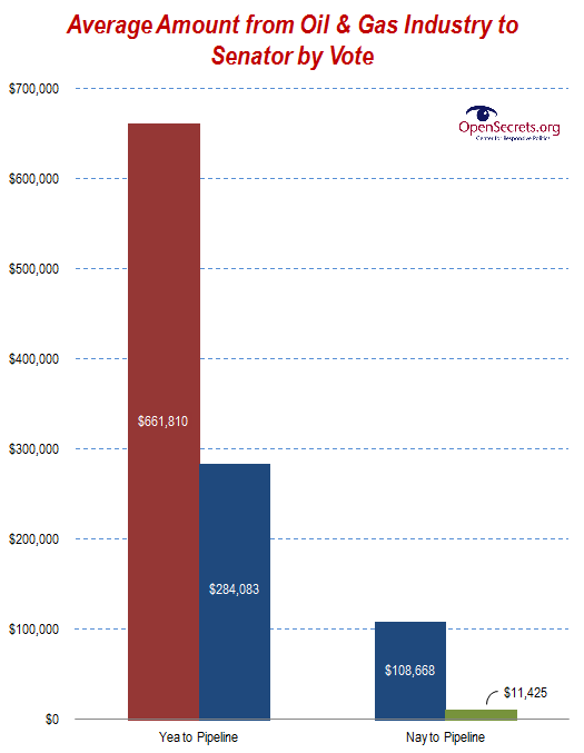
While moneys were received in large numbers by Senators of both parties–and especially by Senator Landrieu, the average about of over $660,000 per Senator voting to approve the pipeline–who, over the course of their political careers, have collectively received over $33 million, in a sort of down-payment, with some $4.2 million going to those Democrats voting “nay.” (Republican supporters of Keystone XL have each received some $662,000 from oil and gas interests.)


Pingback: The Dystopia of Diagolon: Irrational Cartographies of Secession | Musings on Maps