
The Nature in the City map is a site of reorientation to place, loosening its vital forms from the abstract point-based readings of GPS. The city is mapped through a sense of perpetual movement of rocks, animals, birds, flowering plants, and insects across space in Nature in the City‘s new map of San Francisco, which ably shifts our attention from the built environment the focus of most city maps to the harder to map edges of the city, both in space and in time–extending to the past and into the future, tracing the shared space of organisms where what we see as a city exists as an ecosystem. And the edges of San Francisco make it an especially opportune target for mapping–both from it shifting shoreline, to the fossils of deep-sea radiolaria that can be found in its rocky peaks of chert, and the more recently arrived plants or species that have been attracted by human habitats, as seal, to the migration paths of the salmon that have long swum up its streams and whales that have foraged in the kelp forests on its coasts, to the urban forests and hidden streams and waterways in the city that distinguish it from the bedrock schist of many other metropoles. The seismic risks we often associate with the place are not so clearly referenced as the deep history of its evolution.
The stimulating counter-cartography is both pictorially abundant and solidly based on current datasets, that allow us to discover unbuilt spaces of the city that are usually ignored in the anthropocentric maps of built spaces that are largely or entirely paved. Most maps have great difficulty in recording what goes on at the city’s margins, and a-historically represent the city as a timeless complex of buildings, frozen in time, as if to deny their historicity, and glorify the construction of place as a human achievement. The mapping of San Francisco is often no different in its sense of local encomia that meld the built and unbuilt as in printed Renaissance maps that champion the built environment as the true human achievement of a sanctified space–
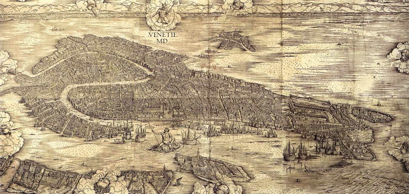
Jacobo de’ Barbari, VENETIE MD (1500)
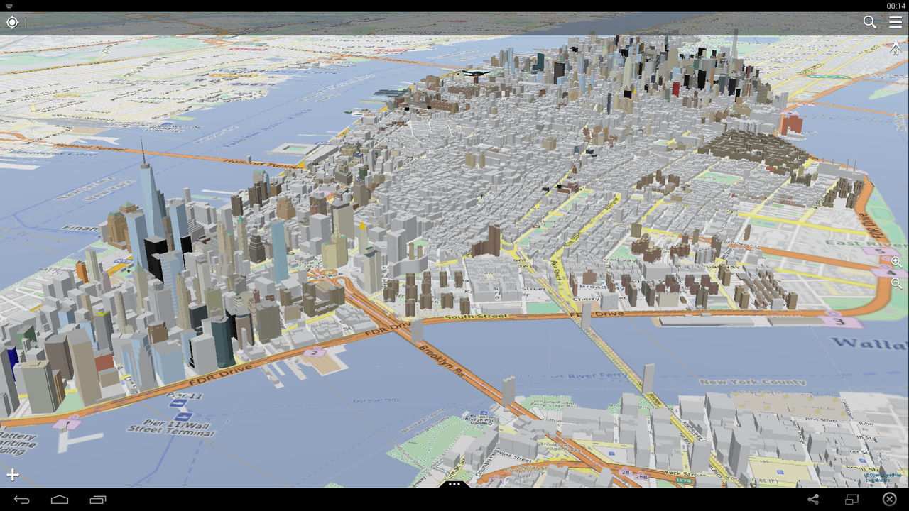
–that both draw wealth from arriving ships as a mercantile center, but was also elegantly isolated from the waters that surround it, even if nourished and fed by the ships at its edges. Even in most recent OSM maps of cities, the mapping of building heights by extrusions reveal a rapidly built panorama that is all but displacing the natural surroundings: it presents the city’s space dotted with bits of light flat green, with only limited attention to the non-built setting.
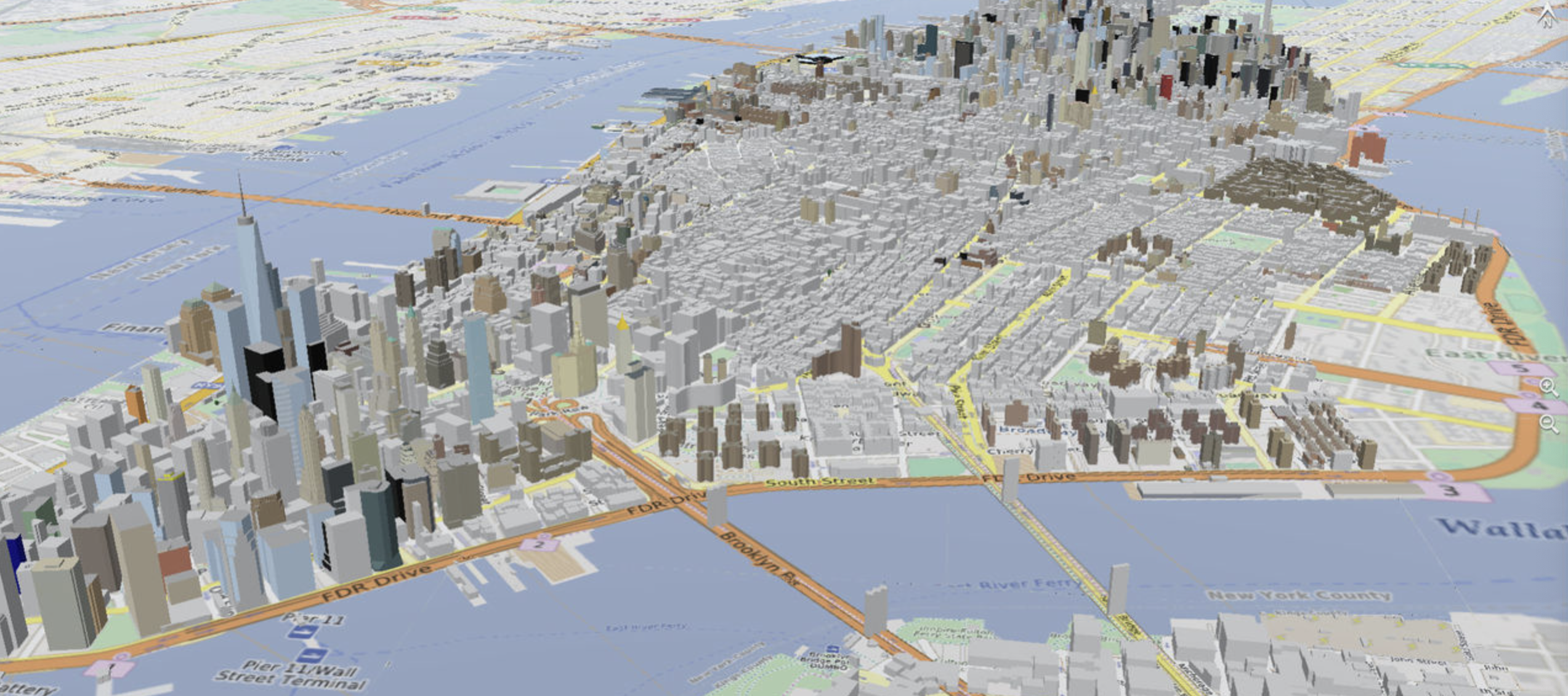
OpenStreetMap, Three-Dimensional Map of New York City (2015)
Both data rich maps of San Francisco use open data to orient viewers outside a hierarchical perspective on place of geographical maps–and explode the illustrative power of local maps by data that places the viewer in close relation to the “nature” of place than the aerial or perspectival view. If such views place space as subject to human vision, the fiction of visual supremacy and coherence is disrupted in both the Nature in the City maps and the earthquake vulnerability of the cutting edge visualizations by which the New York Times invited the nation to orient itself to San Francisco’s newly built downtown to commemorate the 1906 earthquake. If the supremacy of the aerial view is questioned in each, they do so in very different visual strategies of inviting viewers to explore the situating the relation of place to the natural world that such maps invert the celebration of built space.
All maps are selective, but the selection of built environment alone impoverishes our sense of place in ways both maps seem in different ways–and to different ends–to address. And the maps of the built constructions of the city leave out what are often the most important things that move in its structures, lie on the edges of the urban environment, or create new edges, breaks, and interruptions within the asphalted pavement of streets–the cracks of urban topography, that’s where the light shines in. The attention tot he far richer intersections between the open spaces that exist on the margins of buildings and in the interstices of the built environment offer a far more ethical and ethically enriched experience. As metropoles shrink, new possibilities of creating green spaces in the city and relating the city to nature are increasingly entertained. Such attempts have brought us to energize us to see the city in new ways than a built environment, moreover, as cities expand to extra-urban areas: in part, the increased remove of the city from “nature,” and the exclusive focus in maps on the built environment, has led us to become aware of how much is excluded from an image of urban life.
But the dichotomy between “nature” and “city” is perhaps preventing us from attending to how green spaces can be cultivated at the same time as periods of intense urban growth, even when cities face problems of accommodating new residents. San Francisco has hardly shrunk–in fact, the reverse is true, with rising pressures on many neighborhoods to accommodate residents in an era of ever escalating rents, increasing numbers of evictions, as the scissors of a real estate market create a far more populated place that few can afford. But the over-building of its downtown was suggested in a striking data-rich pictorial visualization of increase seismic risks that was printed to invited readers on the anniversary of the 1906 earthquake, in a map focussed on dangers of the density of the downtown expansion–and the embedded nature of the city’s fabric in deep geological shifts,
Roughly contemporaneous approaches of rendering such data–both in the recent map of downtown skyscrapers in The New York Times that asks if we have forgotten the disaster of 1906 and the more detailed, on the ground maps cultivation of existing urban habitat in open spaces. Both engage attention on urban growth, focussing on the man-made coasts of the city to draw attention to the rich habitat it still manages to offer native species–

–or the stretch of towers that have recently redefined its skyline–stretching from the Salesforce Tower to the Transamerica pyramid–whose pronounced peaks and valleys rest on what was long recognized as unstable ground. The mash-up of a past view of the destroyed landscape flattened by offshore tremors over a hundred years ago against the current crop of skyscrapers pose the related question of how anthropocentric our sense of the possibilities of urban building reflect an almost inexplicable alienation from place, and from the seismic threats that building in a recognized liquefaction zone poses, but sees “nature” as posing a perpetual threat to the city’s built environment, rather than optimistically suggest the benefits of appreciating their complementarity.

New York Times, April 17 (2018)
Both maps sift through the vast amounts of open data to offer new forms and formats of urban engagement in concretely visual form, challenging us to develop a new sense of the pictorial coherence and navigation of our sense of urban space beyond a perspective plan. By exploiting the vast image banks and data that are increasingly available to compose a detailed image of place in an era that demands increased environmental awareness.
If the first warns of the dangers of building towers in a region whose proximity to fault lines cannot be forgotten, the second tilts viewers attention from the human-built to the unbuilt spaces of San Francisco which stand, even in an age of what seems overbuilding, as a biodiversity hotspot, where then restoration as sites of animal and plant habitat coexist in the built city. Both turn from the questions of urban growth alone, in other words, to focus our attention on the compatibility of urban growth with the place of nature that has often gone unmapped in plans for expanding a built environment. Nature lies less the specter of fault-lines, however, in the map in the header to this post, than in the islands of open spaces that preserve corridors of wildlife whose restoration offers viable habitat within the city we so often see only as built. And both try to wrestle with the questions of urban development, in different ways.
As increasing amounts of open data are increasingly available about cities, the need to offer such a deep perspective on the temporal axis seems critically important in cartographic ethics, and the richness of both maps suggests the limits of using a slider bar. For time is a crucial element omitted from the hope that data will provide a means to measure the impact of the growth of urban buildings but offer a site for transforming civic space–both by fostering engagement in civic space, and awareness of urban ecosystems–are increasingly explored. And what better way to do so than through elegantly designed maps? While we’ve long drawn lines between the city and the outdoors, as cities grow to mega-regions, and loadspace overwhelms open space, the notion of such a division makes less sense.
14. “The West begins where the pavement ends” is a pithy saying that has long defined the resilience of a counter-geography of open lands in the American west. It was indeed a rallying cry, refusing the paved spaces of the nation. But as paved space permeates the nation, it is impossible to see paved land cover as being so antithetical to nature. Its ubiquity has changed the nation, and our ecology. There seems an urgency to mapping intersections between open and paved spaces, outside of a clear division between the country and the city, if only to gain some bearings of where we stand: is the absence of assessing the impact of paving is to some extent hampered by the training of our eyes to look at paved space on maps, which have the dangerous effect of deeply diminishing our sense of eco-literacy or ecological change?
Both forms of mapping foreground an abundance of nature in the city of San Francisco–underground and above ground–in ways that may not be inherently surprising. But both also shocks the viewer in its outsized proportions, that run against the basic decorum of the static map or maps of inhabited space. Surely the surprise of a city able to contain and even cultivate the green lands–and even nurturing plants and wildlife–seems sharply removed from the rush of urban environments, the noise of cars, freeways, and rush of urban life. For in selecting the abundance of habitats possible in an urban space, the “Nature in the City” project invites one’s eyes rest on the map–without feeling overwhelmed by the intensity of the urban environment, from the coast lines of the city, circled by pelicans, whales, salmon, harbor seals, sand dollars, shorebirds as avocets, and, within its terrain, to coyote and butterflies situates the city not only as built space, but as a geographical nexus of lived habitats that intersect–and how one indeed shaped the other–
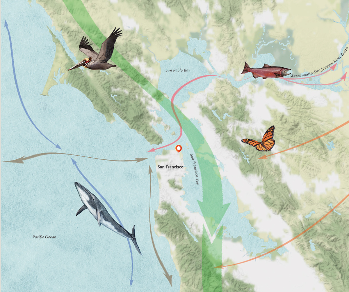
–as a living locus of migration,–rather than orient viewers to its expanding built space, and indeed the premium put on commercial interests of overbuilding by which so many cities are afflicted .
Peeling back the composition of this map, the confluence of backing, data sources, and support reveal the congregation of non-profits dedicated to the conservation and protection of open spaces in San Francisco, and an activist environmental tradition dedicated to documenting and preserving local “bioregions” beside its built space: if Peter Barstow founded the non-profit in 2005, to inspire a conservation movement, the momentum of the Parks Department, Presidio trust, California Academy of Sciences, Exploratorium and San Francisco Foundation have helped promote the project of connecting map readers to the city, as the Nature Conservancy long supported drawing our attention to the relation of nature and the high rises of urban space. Indeed, the mapping of the overbuilding of San Francisco is a map of the exclusion of habitat, and the shrinking of habitat in a city, as well as the ways permission has been given to expansive building If it offers a countermap to the fragmentation of habitat in San Francisco, it has increasingly raised questions of the wisdom and indeed healthiness of allowing overbuilding in a region whose plate tectonics has discouraged and constrained overbuilding almost unique in comparison to other urban regions.
Indeed, considering cities not as sequestered from nature by blankets of urban smog and limits, but sites whose carbon footprints can be reduced starts from actively fostering habitat at time when half the world’s population lives in urban or urbanized environments, which cover only 3% of the world’s surface. The broader crisis of urban ecology led me to be immediately attracted to the sensitive condensation of wisdom and engagement of the environment in a set of pictorial maps of San Francisco. The map’s poetics–not limited to point data, despite its relative richness, rests in shifting the readers attention toward its open spaces, appealing to a sensory reading of the environment akin to taking a walk in wilderness–as Henry David Thoreau–and inviting them to notice insects, birdcalls, or windblown trees–the very sensory characteristics often absent from a map of paved space, which privilege routes above wondering, and a rectilinear organization of space, rather than the specificities of a lived place that our maps often ignore or overlook–but include more than a wanderer might ever be expected to notice on foot. The two maps paired in this blogpost suggest the increasing difficulty to balance San Francisco’s natures–the need to preserve and notice habitat and the seismological risks created by the plate tectonics lying concealed far beneath the surface on which all actual building was confined.


Pingback: The Built World | Musings on Maps