
Donald Trump has presented a new notion of the Presidency to the United States: the open claim to be President of only some of the nation, and to have that model of Presidential rule become the standard for political decisions. This policy was not Trump’s own decision: the retreat from any interest in bipartisan governance that had been the basis for American politics for two hundred years began in the pitched nature of pointed acrimony in the United States Senate that erased the decorum and respect among different interests in a model of collective action for over two centuries.
Already by 2011, the nation divided into spectral schema suggesting slight chance of local bipartisan governance, disguising often narrow margins of political victory, despite eighteen states where Republicans controlled both the legislature and governor’s mansion in 2011, some eighteen were split.
While the pitched fervor of some of our national divisions bears the imprint of faith-based movements, they are replicated in the pointillistic logic of the electoral plans of REDMAP–a concerted attempt of regional redistricting. For the reconfiguration of electoral districts has staked out a problem of governance as a strategy of victory that would erode the project of governance, by privileging “states” as an amassing of electoral votes,– rather than positing the coherence of the interests of the nation as a whole. The concept of governance seems fragmented, bolstered by regionalism, states rights discourse, and the cruel new isolationism of go-it-aloneism.
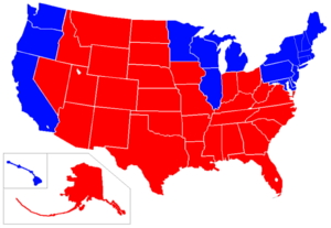
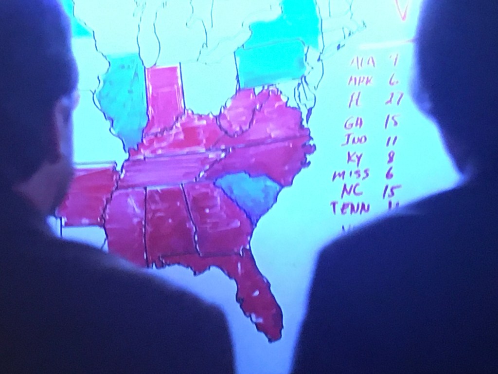
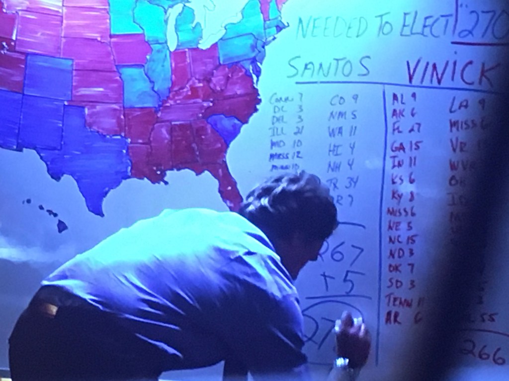
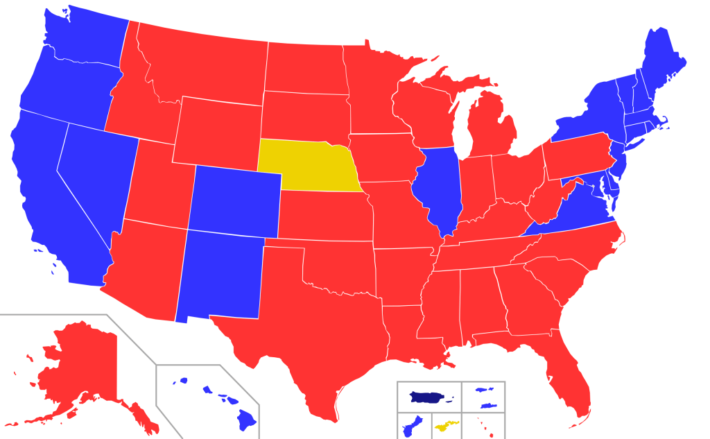
Recast in the optics of the 2020 election as a choice between “darkness” and “light” of truly terrifyingly Manichean proportions, evoking near-apocalyptic scenarios to recast public debate as issues of identitarian self-interest. The divide of states on the 2000 electoral map, which didn’t change much over eight years, enshrined a blue versus red state logic, dovetailing with a deeper plan of retaining electoral control. This was the map was dramatized on election night in a television drama that suggested the contingency of voting preferences, and the election night reveal of the electoral map in the seventh season of The West Wing, in 2006. At a time television newscasters needed to remind their audience states shaded blue sent electors to vote for Democrat Matt Santos (modeled in 2004 on then-Illinois State Senator Barack Obama, who just delivered the nominating speech at another convention), red ones for his Republic opponent, Arnie Vinick–Campaign Director colored a dry-erase board as results were announced.
Obama provided a model for Santos as a candidate not defined by race, pivoting from race to underlying unity among red and blue states, but the restate-blue state divide was militarized. And when Barack Obama was re-elected in 2012, the Republican state legislators in Virginia, Michigan, Wisconsin, Pennsylvania, and Ohio adopted the idea of ensuring Republican victories by rigging the Electoral College according to the congressional districts that they had redesigned, rather than in bulk, in the hopes to skew the distribution of electors by the congressional districts they had guaranteed would be firmly red, having designed districts that even in what were considered “blue” states had “red” legislatures. m so that districts would be assured that they would not be “outvoted” by urban metro areas would dictate a future.
This gave rise to the logic that asserted the “rural” non-metro regions should reclaim a place at the table by recrafting representational politics to give new meaning to those who increasingly feared–or felt–that their vote just didn’t count but felt that their futures on the line. By redrawing districts, legislatures magnify rural interests outside large metro areas, offering a logic magnifying their political representation through congressional districts as power bases and political divides: not by blue and red states, but by a red republic, in need of its voice. The plan to self-segregate matched a strategy of segregating separate electoral votes from the popular vote worked by recasting electoral districts on party-skewed lines, independent of any geographic shape save benefitting one party, at the expense of another, at violence to the republic. It was echoed in a tactic of political obstructionism that provided the logic for “red” areas to be increasingly opposed to current governmental policy in the Obama administration.
The reduction of debate between parties may have begun on a local level, but metastasized nationally in legislative maps. The rationale of legislative bodies has shifted on local levels from a representational logic of governance to a pitched battle–as only one party wields legislative power in all but one state in the union.
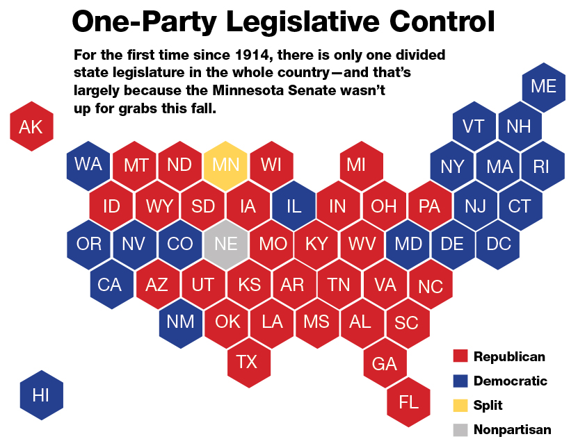
The disorienting nature of an overdetermined power play means that there is not much discussion or debate in the local states, or legislative bodies, but a sectarian consolidation of demographic identity as destiny.
The division of parties cast “red” and “blue” as forms of governance essentialized the color-choices made in news maps as almost existential terms. Indeed, the increased casting of the 2020 Presidential election as a battle between “light” and “dark” was gained distinctly apocalyptic undertones fit for the age of the Coronavirus, mapping the current elections as a referendum of the “future of American democracy” or, for President Trump, a “bright future” and “dark future” whose oppositional terms echo a religious eschatology. Was it any coincidence that the separatist blood-stained banner of the Confederacy reappeared at Trump campaign rallies in 2016, jumping the logic of a chromatic divide into opposing visions that could be understood as a nation divided in war?

As candidates proclaim themselves to constituents as an “ally of light, not darkness,” the choice of the election has turned on the complexion of the nation’s political future in ways that concretize the removal of maps of support of political parties as an existential struggle for the nation’s soul, removed from questions of political representation.
The eery blocks of political division were apparent in the long led-up to the election, as the fracture lines in the nation were only less apparent because of increasing tension as to which way the highly colored states in play would slide, and how the electoral prism would mediate the popular vote.
The notion that a specter of socialism haunts America, to be promoted by the Democratic Party, is the conclusion to a logic of deeply sectarian politics of belonging.
The politics deployed wrenching topoi of danger and difference, in terms not only of grievances, but of a starkly divided landscape that raised the question of the very possibility of political consensus and the pragmatics of political representation. And while rooted in the renewed role of religious zeal in partisan politics, the fervor of opposition to–and defense of reducing insurance for pre-existing conditions–by laws like the Patient Protection and Affordable Care Act–Obamacare–as if they were articles of faith.
Yet as the 2020 election had quickly shaped up into a contest of chromatic separatism–
–the deeply oppositional dynamics of the divided landscape bode deep difficulties in governability.
1. The fault lines of the Republic burst to prominence not in the actual elections of 2000, or 2008, but in the toxic politics of opposition that rejected the role of a chief executive as filling the representational function of his office as Barack Obama served as U.S. President. The increased division of the nation into different sense of its place in the world was evident in the refusal of the governors of first eighteen and then twenty-five states to let Syrian refugees settle in their borders, parting from immigration policy in the Obama administration, before Trump divided the nation by lines of America First on his 2016 Presidential campaign, as twenty-seven states to “refuse” the acceptance of refugees prepared a striking swath of red in the midwest and south in a starkly divided terms–
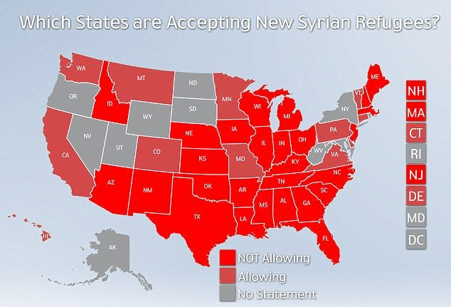
–a block whose number that quickly escalated to thirty–
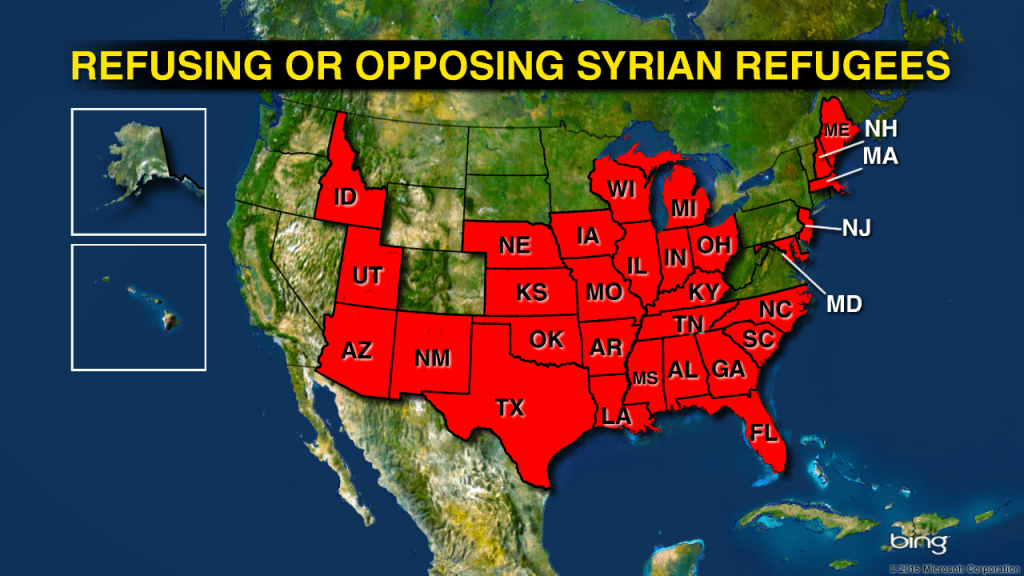
The policy pronouncements of governors on asylum recast a states’ rights discourse in globalist terms, laying down the “law” on the resettlement of Syrian refugees that recast what were universal humanitarian interests of granting asylum as policies that governors in fact have no right to decree. But the near-universal declaration of local policy unmanned a national policy, in terms that responded to the growing fear of terrorism as over half of local state governors took it upon themselves to refashion American policy, as Republican governors uniformly barred the possibility of refugee resettlement policy, signing local executive orders, openly attacking “those who will try to take advantage of the generosity of our country’ to contest a national policy of refugee resettlement in 2015 by rejecting State Department Policy and overturning longstanding human rights policy–contesting Presidential policy by closing their borders to Syrian refugees. The United States was even recast in an ostensibly “explanatory” map of the nation as painted in stunningly Syrian colors.
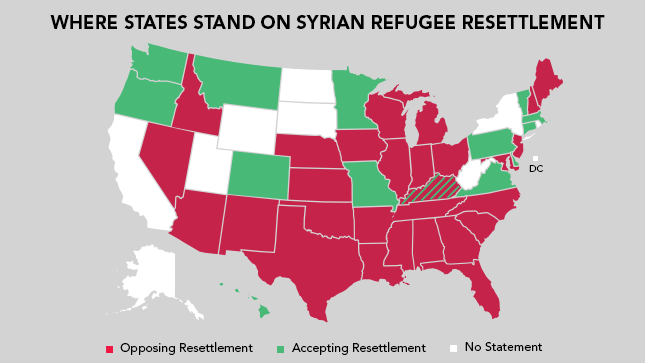
Twenty-eight governors elected to defend the interests of residents in their states were speaking to their local supporters, assuring them of toeing a party line, that morphed the United States to a globalist versus a politically tolerant politically attitude to resettling political refugees.
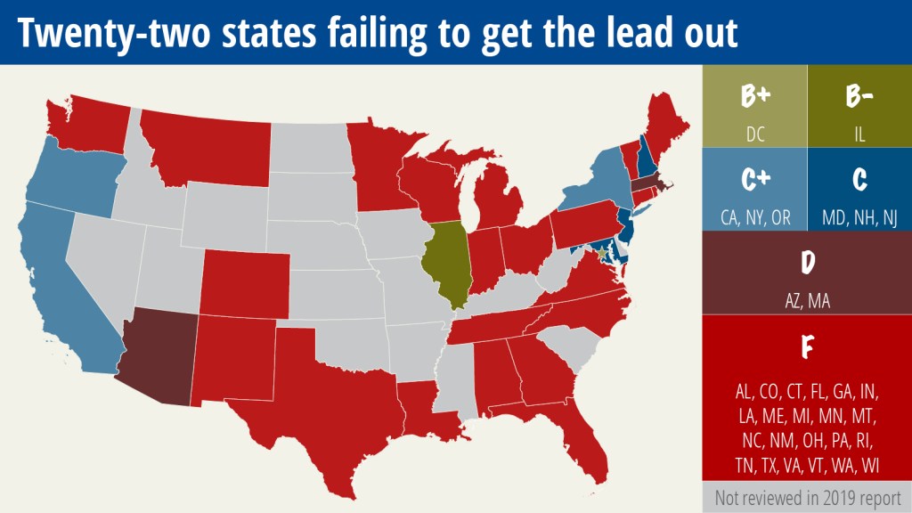
The stark division extends to domestic priorities, as well as being a categorical confusion between domestic security and international policy. The parting of waters in domestic policy divisions map onto how twenty-two states rebuff guidelines to remove lead from school drinking water, five years after the Flint MI tragedy, and resist proactively replacing pipes and drinking fountains to reduce health-threatening lead levels.
Divisions among states are reinforced by data visualizations that naturalize our nation’s political topography by divides uneven health security, acknowledging pre-existing medical conditions. There is even growing reluctance of residents of “blue” states to take holiday vacations on beaches in “red” states–leaving large sections of the national shoreline voluntarily “off-limits” and taboo.
Fears of inter-state ruptures extended in 2014 to a threat of monetary secession, wresting states from a single currency. Fears of a broken union on Money Morning–Your Daily Map to Financial Freedom!–threatened the impending rejection of paper money across “red states” wise to financial instability whose residents were adopting digital currency, in a thinly disguised promotion for Bitcoin–“now accepted by dentists in Finland!”–to trigger almost reflexive fears of a specter of monetary separatism even if it was hardly in the works: the fracturing of an unstable union had currency of its own.
The visualization of dismantling the monetary union of paper currency is an old echo of fears of leaving a gold standard, but eerily echoed the very states’ right logic of the secession of southern states to defend the institution of slavery; investment in digital currency was the new go-it-alone-ism, leaving behind neighboring states in the dust of outdated financial markets: the blue state of California is red due to outsized Bitcoin investment in Silicon Valley, skewing the entire state from the union.

Is this the real end of America?
When Donald Trump began his first campaign for the U.S. Presidency by tropes of tragedy, declaring, “Sadly, the American Dream is dead,” he may well have announced an end of American unity that had already been mapped. In a weirdly toxic combination of the “states rights” dogma and the new isolationism, the Republican “Redistricting Majority Project” that was the brainchild of winning control of state legislatures to redraw the electoral maps in advantageous ways, advanced a pointillistic principle of designing democracy since 2010, bearing first fruits by 2012, when the concentration on local elections in traditionally “Democratic” states that could be engineered in electoral districts to be made to “swing Republican” bore fruit in winning more seats of congressional Representatives, even if gaining less of a share of the popular vote.
GIS software helped to redistribute data points derived from voting patterns to jigger electoral districts by “Create-A-Map” Map Wizards offering to translate discrete data points into spatial “joins.”

The ability to set GIS sights on the electoral maps of states as Pennsylvania, Ohio, Michigan, North Carolina, and Wisconsin–some of the new “battleground states”–were achieved through redistricting, to protect seats in the U.S. House of Representatives, from 2012 to 2018. And although Democratic candidates won more individual votes than Republicans, they failed in 2018 to take legislatures in Michigan, Wisconsin, Pennsylvania and North Carolina in 2018.
The re-engineering of the electoral map for partisan gain–a widespread practice of gerrymandering on local levels–emptied the electoral map of its own representational functions in order to play for a long-term partisan gain: previous instances of gerrymandering were not limited to Republicans–Representative Philip Burton, a Democrat, boasted coyly that his own rejiggering of California’s electoral map could be understood as “my contribution to modern art.” (Burton ensured legislative ascendancy of Democrats by maps that reapportioned by the crude proxy of registrations of Volvos and Buicks, but the redrawing of districts that Governor Jerry Brown approved prevented Californians from contesting the Republican redrawing of district to alter its legislature.)
But they removed the map from its representational functions in quite explicit terms of ensuring partisan advantage. The new policy raised the question, in effect, not only what states were, but what the district or county was in a notion of representative government. Praised as the “gerrymandering that brought Republicans to power” while, as Julian Zelizer observed, “the problems created by gerrymandering are symptomatic of larger challenges facing the parties,” the reconfiguration of the national nature of parties made them rooted and deformed by the electoral maps that were once supposed to help ensure the democratic allocation of votes, by redrawing districts that the doubling down on local politics had allowed, packing and cracking districts by mapping software tools to fill an increasingly interests-based appeal based on data of voting tendencies.
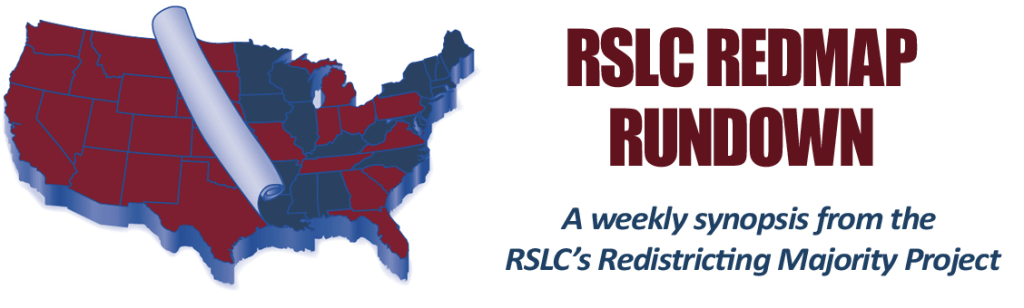
The realization that state legislative control could provide a bulwark against Democratic majorities became one to solidify Republican-tending regions, a new “southern strategy” to turn to the blue-tending map evident after 2008 red. Reworking electoral maps to skew districts to allow Republicans to “retake” the majority became the aim of what was described innocuously as a “project” became policy within the Republican Party, despite its non-representational agenda: the principles developed in the RedMap campaign as a project explicitly designed to re-aggregate the nation to partisan advantage–hence, “The Redistricting Majority Project”–to “fight for a fair process” in redrawing electoral districts, with hopes “to create 20-25 new Republican Congressional Districts through the redistricting process over the next five election cycles, solidifying a Republican House majority.” The Official Redistricting Director used the 2010 census for data points to reedraw the maps for multiple states close to the Republican column–Alabama, Pennsylvania, Texas, and Virginia–by GIS programs to redraw districts as skewed as possible to a partisan advantage, attempting in Barack Obama’s presidency to eliminate the prospect of a minority- majority nation. New districts diluted votes of minorities who tend to vote Democratic “in ways advantageous to Republicans and non-Hispanic whites”–by rehabilitating suppressed desires of disenfranchisement across much of the nation. The explicit goal was to create “permanent Republican majorities” by imposing new electoral maps atop the actual lay of the land with the aim of frustrating the electoral process, rectifying a “structural deficit” keeping Republicans in the minority, by compromising a representational process, while leaving a representational system intact.
Outright fetishization of districting as tactical tools of warping electoral maps was newly enabled by software tools designed specifically to leverage partisan agendas for re-engineering electoral politics. Such “gaming” of the electoral process by the redistribution of the popular vote paved the way in part for the 2016 Presidential election, as it set precedent to implement full control of legislative bodies to coordinate national redistricting as a top-down process of using racial data to redraw legislative districts, that seemed designed to skew the nation to a pitched partisan battle for advantageous schema for representation that resembles. a battle for territory or a creation of fiefdoms, encouraging homogenous safe-seat districts, fostering “mutual animosities” among parties on the map, and undermined representational democracy. The effect was to extend principles of legislative obstructionism on a map that itself massaged the mechanics of democratic institutions; persistent doubling down on state politics after Obama took office led an onslaught of often misleading advertisements alter the flavor and tenor of political discourse.
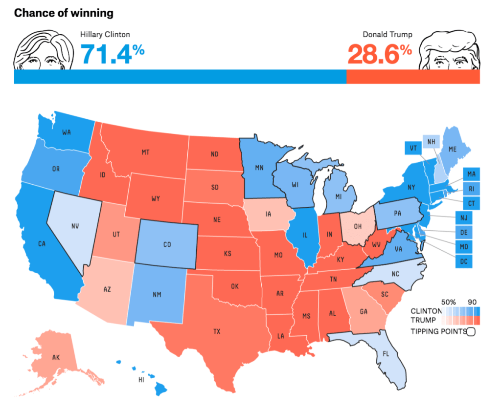
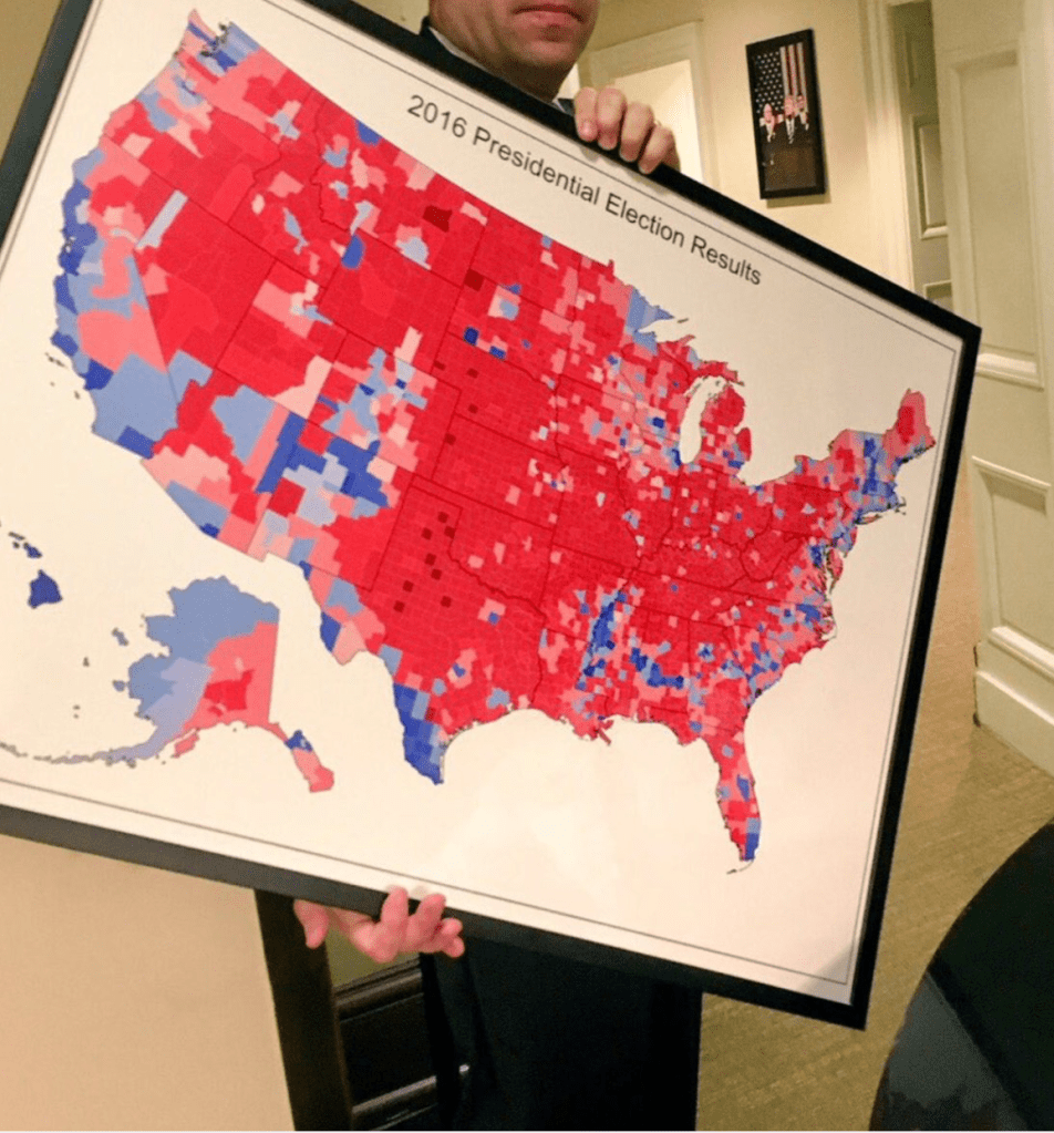
2. The fetishizing of a chromatic distinction once a graphical convenience naturalized a semantics of opposition in claims of electoral victory trumping the popular vote in 2016, presenting a chromatic division both as a symbol of political division and an icon of Republican victory.
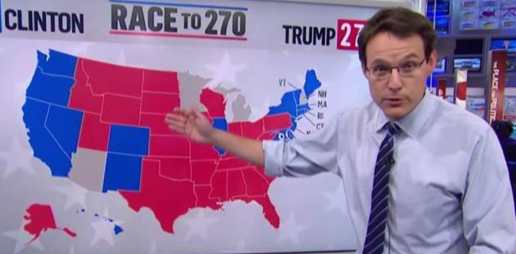
The designation of states by colors was adopted by newsrooms to create stark color contrasts for their audiences became a way to reveal an alleged divide in the nation, and increase the toxic sense of national division. The presentation of a map of the electoral distribution of votes in the 2016 election was celebrated as a mandate–as the compelling map of delegates that led to the electoral math of a victory on the news in 2016, that cast the election of the U.S. President as a “race to 270”–presented with animated urgency, as if the map mediated a spectator sport, akin to a sport event, to which removed observers were asked to cathect–as a contest that seemed to replicate territorial division, divide the nation into never so previously seen stark terms, mapping a new reality or substitute for governance that we are forever on fated to adopt.
The notion of revealing an underlying reality in an electoral map is after all a rewriting of the polity. The image of division hung on the White House walls should have alerted us a new logic of governance and representation: the results of a contest were narrativized as the “results” of the election has has become itself an icon and logic of governance, and understood in increasingly explicit Manichean terms, with the growing demonization of “Democratic” mayors, governors, and officials during the George Floyd Protests or the Coronavirus, as bad elements, that seemed to follow the logic of framing a wall-map in the White House, as if announcing a logic of rule.
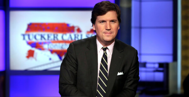
The same map was the backdrop to mediate national news. Tucker Carlson asks we internalize the implications of governance from part of the country, asking we recognize that the President guiding from the part of the nation that elected him, or the exaggeration in a red block of underpopulated regions that anointed Trump as U.S. President and that he regarded it as his mission to lead–and that would ensure him a mandate in 2020, putting a brave face of confidence in the insanity of inhabitants of those blue states that seem to lie not on coasts, lying on the margins of national consensus and open to ridicule.
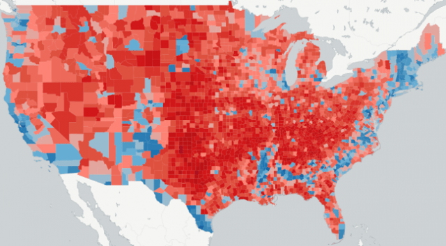
This is far cry from maps as a foreign policy tools to define a geopolitical target. The current permutation of America First to a language of craven self-interest, of benefiting masses, rather than elites, questions the logic of governance outside securing personal gain. While the notion of map of the nation was more clearly based on districts or counties, that reveal the far more complex variation of the landscape in any state–if Vermont is all blue, perhaps only Oklahoma is all red, if some other states do come close to a monochromaticity, from Louisiana to West Virginia, few in fact are.

But it compels us to ask what states really are in a landscape that privileges electoral politics over democratic institutions, as the instrumental use of the state as a category that can be jiggered in just the needed way to guarantee the outcome of apparent territorial magnitude manufactures a consensus that is illusory, but is the the tail that increasingly seems to wag the dog.
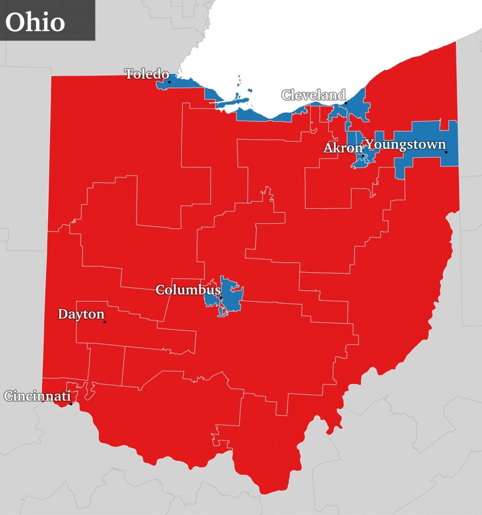
The notion of a hallowed “Map Room” the preserve of an executive ability to frame targets of military action in a real world, now seems hard to conceive as a basis for map readership: the plans of political operatives like Karl Rove, after learning lessons from the election of W., organized a plan to gain majorities across state legislatures as a logic to win national majorities that generalized the lessons of hanging chads to the nation, under a mantra “He Who Controls State Legislatures Can Control Congress.” The aim to flip the districts of Pennsylvania, Ohio, and North Carolina forged “bellwether” states by redrawing their congressional districts in distinctive shapes.
The electoral map, after all, sets the stage for a new relation to national identity: it mirrors the benefits of fealty, in an ancien regime relic, whose map is removed from national interests, or perhaps reference to a “real” world. The large wall-mounted map consulted by President Roosevelt in his private study indeed is as removed from the four black bakelite rotary telephones that were posed on the desk beneath it, all reduced to quaint relics of a removed past–and if Roosevelt used the collection of maps to orient himself to the world to better grasp each theater of operation, in a survival of the paper map that National Geographic cartographers often personally installed, is it possible that Trump’s fetishizing of the map of red and blue states provided a template for domestic governance, constituting a warped revision of the once respected doctrine of America First?

The map provided a sort of self-congratulatory navel-gazing that has removed the Presidency from the government of all, running against the deepest underpinnings of representational government. The current war waged on social media by the United States president to cast himself as the “law and order” candidate runs against the aim of political representation, attacking “Democrat cities” as enemy redoubts from which to wage a war of attrition, or abandon outright and excise from the Republic as sites of cancer in the body politic. Trump, in retweeting antagonistic threads that seem to expel sites from the body politic, seems symptomatic of someone without any sense of public service, who engages partisan dividing lands as if they did not belong to the nation.

3. If all maps are data visualizations, the recently troubling revelations of the management–or mismanagement–of Coronavirus is a sad reminder of the remove of anything like a map of governance for all: the blatant efforts of preventing a nationally centralized response to the pandemic that was described as the central logic of the response team engineered by Jared Kushner with some college buddies, and an assist from Marc Andreessen seemed, even as over 2.4 million Americans had contracted COVID-19, orders testing kits for $2.5 million, from a murky vendor in Abu Dhabi, in deals worked out over WhatsApp, that makes one think mostly of how to profit off of the virus’ growing spread: without any laboratory experience that might have suggested that shipping so many kits whose reagents had to be kept cold through Abu Dhabi was of questionable national benefit in the long run, especially in the urgent need for a national health plan: the coronavirus task force suggested that the need for moving forward with a national plan, which was less viable with the chief executive for a virus that had, few could fail to note, in fact hit blue states hardest.
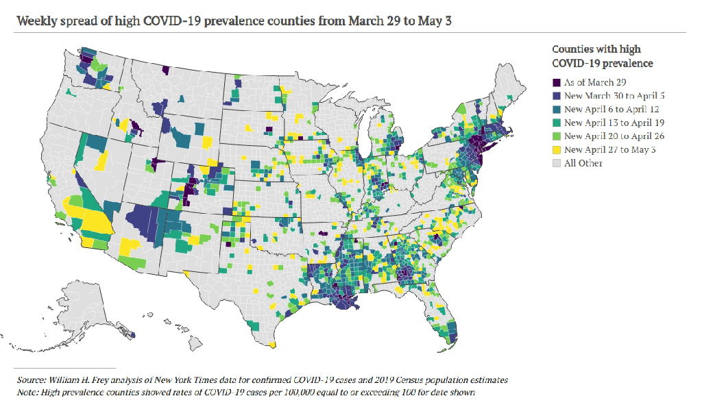
Perhaps the impossible matching of a state-based logics of clientism with a national health system–let alone a national health emergency–reveals the limited meaning of “states” in a crisis where contagions move rapidly across state lines, even if we continue to use choropleths that are inadequate to the spread of contagion, employing poor metaphors as “hot-spots” and state-based metrics, that provide little orientation to the topography of an infectious disease, that seemed confined to predominantly urban “hot-spots” on the east coast, as if they constituted isolated datapoints able to be off-loaded to mayors or governors. The virus mutated and spread across the country it became a national problem by summer: after empty assurances that the coronavirus would lift with rising summer temperatures, as the flu, infections and hospitalizations have emerged on hundreds of wars fronts that cannot be compared to a coherent struggle any more, and that stand to overwhelm inadequate health care systems.
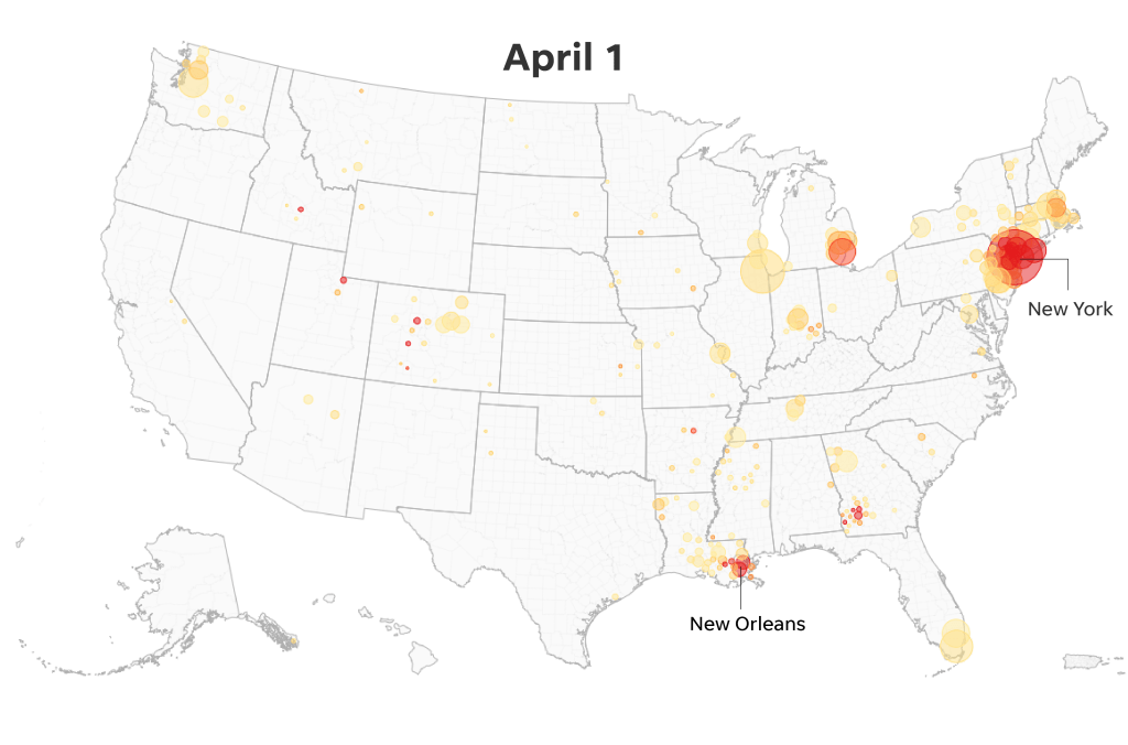
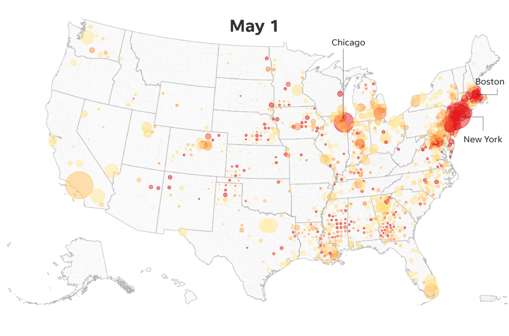
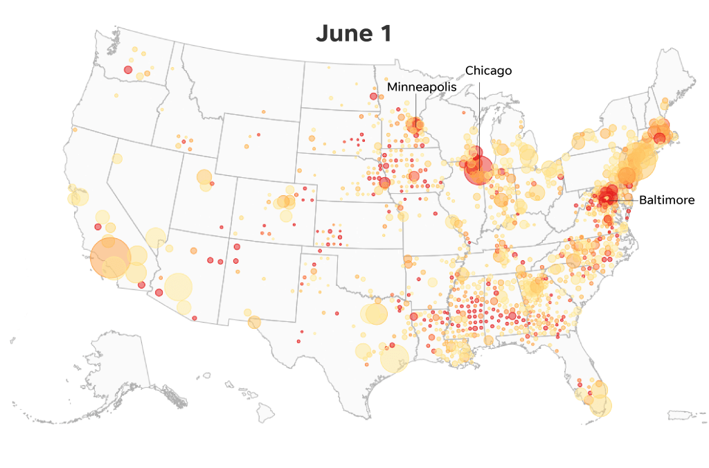
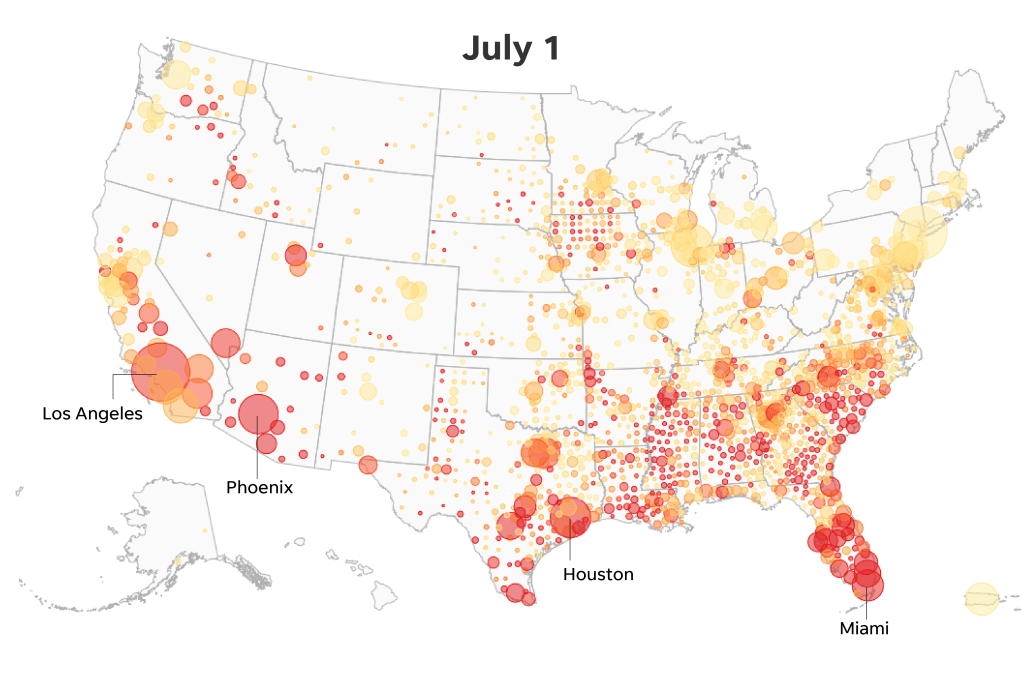
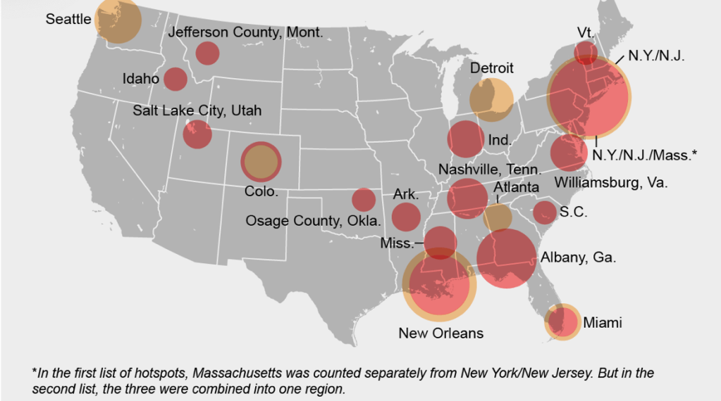
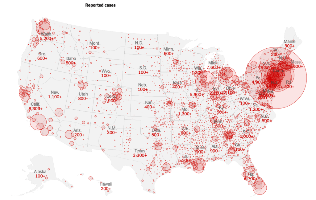
Can we even argue that the semantics of “hot-spots” that the pointillist mapping structure meets needs of health care? Even attempts in April to track a set of “hot spots” in the nation had begun to loose all pointillism, as it became clear that the “tracking” of points of outbreaks for a virus which was often carried without manifestations, and which incubated in the body for up to two weeks, eluded the cartographic pointillism that might make sense for data points of electoral tendencies cultivated in national opinion surveys, but moved with its own patterns, as if it had some sense of hidden agency, and condensed the flow of population as it reflected the often overlapping and interconnected ways we inhabit indoor space, leading any list of “hotspots” to meld, merge, and overlap into large red dots.
The Coronavirus Task Force, schooled to view the spatial distribution of infections through an electoral prism, felt a national plan less necessary–or just unnecessary–as it had little sense as a “political strategy.” Even as Dr. Athony Fauci crossed his fingers for the finalization of a national plan that would include the “largest public health testing program in American history,” from the Rockefeller Foundation, a partisan filter seems to have discouraged hopes for centralizing COVID-19 testing. The tendency to enlist firms and individuals without government expertise, a Trump habit, has mirrored the offloading of responsibilities to individual states; Trump endorsed plan sto use LabCorp and Quest Diagnostics, by late April 2020, rather than consult expert opinion, placing the football of the virus evolving in new ways in someone else’s court.
Of course, virulence had yet to develop virulence in many regions. yet the dominance of reading counts of COVID-19 infections in state-by-state terms, even to the extent of encouraging states to bid competitively on PPE and health equipment: per Vanity Fair came the mind-blowing revelation by a member of the task-force Kushner ran, “The political folks believed that because it was going to be relegated to Democratic states, that they could blame those governors, and that would be an effective political strategy.” Why, in short, create a national oversight group over all those red states that the REDMAP revealed, when those regions were flecked with pink dots, rather than the deep rose of the TriState area, where coronavirus infections were cast as a purely local problem.
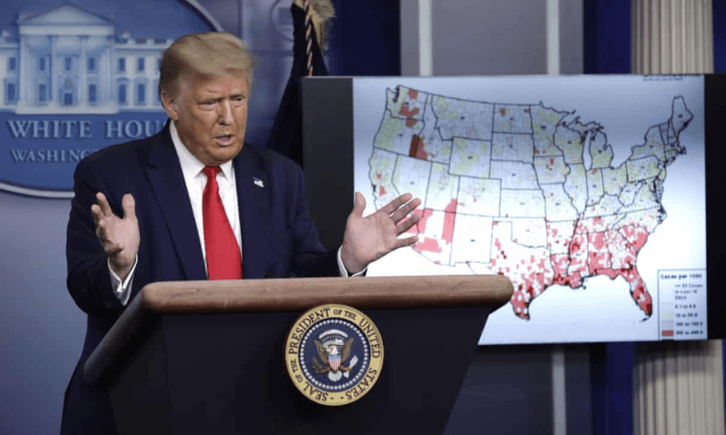
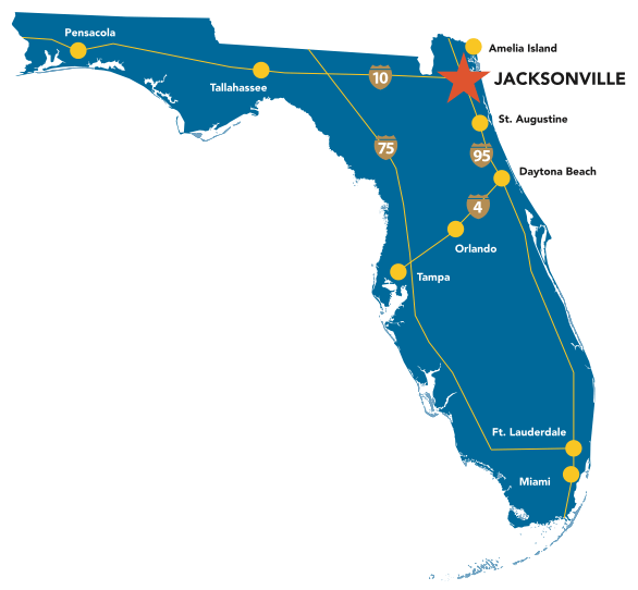
The weird tentatives to frame the “response” in national terms fell on the shoals of a resistance to create any visible national oversight of states rights–an important element, to be sure, in the Republican casebook and battle strategy. As a muted map suggested patches of the nation where infections were high in a less shocking manner, a mask-free Trump allowed at a late July news conference that the planned Republic convention slated for Jacksonville, FL may need to be canceled in “what turned out to be a hotspot, as the state’s governor himself had to concede over 10,000 new cases of COVID-19.
Due to the ferocity of the coronavirus pandemic, prudence indicated “it’s time to cancel the Jacksonville, Florida, component of the convention,” given “what the media would say”–and time to call in the producers of The Apprentice to stage the convention, even as the older and most senior Republican senators–Iowa’s Chuck Grassley and Utah’s Mitt Romney–had bowed out “because of the virus situation.” Trump promised to appear each of four nights on prime time, but conceded Jacksonville to be one of those discrete hotspots just not right for the event.
If globalization can reveal deep interconnections of any two points in the globe, the receipt from Abu Dhabi’s Cogna Technology Solutions LLC for an American client identified only as “WH” in late March 2020 to procure three had a half million testing kits for COVID-19 from a Chinese supplier mirrors the virus’ global migration. Spending two and a half million to get untested Chinese test kits on the cheap came at a time when the notion of a national pandemic response seems tied to a testing system raises many questions. Although the hope for some 3.5 million tests arriving onto American shores would have been good news indeed, the deep reluctance to formulate or invest any nationally centralized body with authority over their distribution noting acquisition of test kits by a client disguised as “WH”–only ham-fistedly concealing the requisition of test kits approximately the size of the U.S. population–for an entire nation, reducing a national health care policy to a single bulk order of test kits that were found to be insufficient, and for which the administration in the end refused to pay.

What would have happened if Kushner’s group’s plan for national oversight to coordinate the allocation of test kits have come through? What would have happened if a virus surveillance system have materialized as desired? Hard to say, as the winds ran the other way, and weight shifted to the states in late April, the absence of such planning has deeply cost the nation, as Trump and his cronies have resisted any need for federal oversight of the nation, and even denying the need for a transparent tracking outbreaks of infection and hospitalization as if this were not in fact a governmental responsibility. Removing tabulation of COVID-19 cases from a publicly accessible repository would take the wind out of the sails of researchers across the nation, but would line the pockets of a medical data company owned by a shadowy former real estate investor with close ties to Trump International, Michael Zamagias, who as his real estate investments went south shifted his attention in 1991 to centralizing the tracking of medical data–not solutions of patient care.
The Cogna Technologies offer to ship three and a half million Chinese-made testing kits for COVID-19 under the table seemed a neat trick for Jared Kushner to pull out of a hat, a bargain at two and half million dollars payable on receipt. But the absence of national oversight did not in the end, seem politically advantageous–as if the notion of a centralized policy of COVID-19 was anathema to the Trump administration, who have hectored the nation in terms of blaming local governors, rather than suggesting any coherent national strategy, save reopening schools, and pronounce “reopening” states where sheltering in place was advised for the nation to “get back to work”–even as COVID-19 prevalence increased in many states as they were preparing to “reopen” in the west and in southern states.
The President was hardly a fan of promoting increased testing for COVID-19, or for involving government agencies in a response. Alex M. Azar II met Trump’s needs again in cutting off any hopes for transparent COVID-19 testing, as if shifting the job description of a Health and Human Services Secretary, by asking hospitals no longer to report coronavirus patient data to the Centers for Disease Control, but to a privately run proprietary database whose collection practices sufficiently removed from public view to be shrouded in Non-Disclosure Agreement, that most favored instrument of hush-hush. By tying all medical funding set to hospitals to cooperating with a new COVID-19 database, bypassing the CDC, but made coronavirus relief payments contingent on submitting all data to Teletracking Technologies, boosting their own possession of the sole complete database would effectively sideline proven public health experts, and hiding data from public site, and removing expertise from public government officials as COVID-19 spread.
Only after significant public protest by public health experts did Health and Human Services offer a revamped website, the H.H.S. Protect Public Data Hub, that made public its analyses of data public amassed from hospitals, far less user friendly, in ways that have raised questions of increased lag in reporting; the data also reveals the increased remove of TeleTracking from actual onsite data, and its data metrics make it difficult for hospitals to verify the data’s accuracy: by bypassing the CDC in the tabulation of data that will allow one to make predictions about hospital needs, and public knowledge of the virus’ spread, the centralization of all data on the coronavirus not only erodes the role of the CDC, but removed the data collection from both expert judgement and from the agency’s history of data collection in suspicious ways, removing it from researchers, plans for reopening schools, or sheltering in place orders.
By linking all these efforts to folks without governmental training or history, did Trump imagine that he was better served by seeking to continue to keep the numbers under wraps?
The call for privatizing data on coronavirus infections echoes presidential pronouncements decrying the growth of testing, as increasing COVID-19 testing would only grow the numbers and create panic, hurt the markets, and create insecurity. While Trump pronounced his administration has offered access to “the best testing in the world,” and allowed Americans access to “the most advanced and robust COVID-19 tests in the world,” in late July 2020 healthcare briefings, the pronouncements strain credibility; the claim that “thanks to President Trump’s revolutionary testing efforts, we have ben able to track cases better than other countries” is not only deceptive but vainglorious boasting too late to the game to matter much: the very distribution of “rapid point-of-care tests to be distributed to nursing homes in COVID-19 hotspots” ignores that hot-spots are no longer spots, but have multiplied across the nation; boasts that Trump has helped the United States to build the “robust testing system” that other nations lack conceal the ham-fisted way that the pandemic was approached, and reluctance of the current administration to develop the very ability to track the infection press briefings argue only other nations “have not been able to capture as full of a picture of the number of cases in their populations.”
President Trump has long argued increasing testing creates higher numbers of cases of infection, in ways that would unduly scare consumers and financial markets, or hurt his own presidential press conferences’ ratings. Agreements to create a system of tracking and testing bear careful scrutiny as efforts that are really in the national interests and public benefit. After agreeing to sign nondisclosure agreements about practices of tabulating a centralized database, TeleTracking was awarded a no-bid $10.2 million dollar contract to replicate the job of the government agency of the CDC for reasons that won’t be soon revealed, although duplicating the function of a government agency by practices guaranteed to be opaque, with limited oversight, seems a deep public disservice. The contractor approached signed a nondisclosure agreement, attached by the White House or by Health and Human Services, to create a centralized testing agency that would be off the books; it rebooted Kushner’s hope of a “national Sentinel Surveillance System” or virus surveillance system to pinpoint subsequent outbreaks of COVID-19,–but by data collection practices are to remain secret, and based on a computerized model of medical data collection.
The assurance that specifications for the system would stay under wraps, without precedent in federal responses to public health data for infectious diseases, came an assurance TeleTracking’s results could–after the 2020 election?–be available to members of Congress. Such a promise, despite oddly uneven quality of a system, evades the central question why pandemic health data-collection should become less transparent. The shift to a new basis for tracking system may endanger scientific integrity as well as burdening health care industries, removing data on current rates of infection from experts on infectious diseases at CDC may: Covid Tracking Project, which has long tracked local sources of infection to provide the absent national picture detected a number of “major problems” of a systemic nature in the TeleTracking system run out of Pittsburgh–a data firm rooted in the use of emergent technologies, online medical databases, patient-tracking portal boards, but without expertise in health care–run by Michael Zamagias, whose past practice in residential real estate was removed from health care, hardly the figure likely to be entrusted with assembling and maintaining the most critical medical database of the governmental at a tie of national uncertainty. The shift disempowered researchers, hospitals, and public health institutions, by exercising proprietary ownership over public data that might not see the light of day.
Although Zamagias boasts the TeleTracking offers excellent health care benefits for employees, in an attempt to distinguish its desirability as a workplace, the entrusting of such a massive task of data collection to a private company raises eyebrows, as Zamagias’ experience seems to be as a GOP donor, with long historical ties to New York real estate markets, including the financing of Trump Organization properties with billions, before investing in the start-up TeleTracking to diversify in healthcare technology. While medical data providers were a cutting edge need since 2015, as health care providers note huge need for a computer-readable national medical database, centralizing data-points would provide a unified basis to confront COVID-19, removed from the sort of access researchers and the public expects: Zamagias’ company would provide a centralized sort of disaggregation of medical data our national readiness, inaugurated by a pronounced decline of transparency in tracking infectious diseases. The decision to put the onus on local hospitals to set up new reporting systems to track data outside the C.D.C. governmental agency shifts daily tracking requirements in midstream, as it were, lest it be tabulated in full.
What this means for the future of health care is not hard to see, but is terrifying. The TeleTracking contract seems designed to provide health care at all. While tasked with ensuring we have “data visible to first responders at the federal, state, and local levels” TeleTracking will not reveal how it tracks or creates its data. While COVID Tracking Project found “the federal data continue to be unreliable,” the hoped for use of TeleTracking data to allocate ventilators, perhaps open schools, and even distribute necessary protective equipment; as the nation faces its greatest health crisis since AIDS, rather than being run by a health-care professional or trusted epidemiological experts, TeleTracking’s majority owner and chairman is a Pittsburgh real estate developer, with minimal experience in health care, but seems to specialize in machine learning and “real-time predictions” based on data and developing information architecture, without anything like a national Chief Technology Officer, an innovation of the Obama presidency that Trump dissolved.


This puts together and “maps” the intuitively dissonant but tactically successful republican takeover at a local level to ‘divide and conquer’ as a national agenda. The strategy fits together analytically here in ways that the press and the pundits haven’t grasped. Should be read by anyone serious about understanding American politics and “democracy.”
Clarifying; chilling.
Pingback: How to Levitate an Elephant | Musings on Maps