
It is pretty hard to imagine anything as scary as the intentional clearing of The Jungle near the French port of Calais. The dismantling by local police of improvised structures of lean-to’s, corrugated metal, stretched plastic tarpaulins, wooden structures, and improvised settlements that had sprung up near the Port of Calais for three years had housed many families of migrants from Afghanistan, Eritrea, Syria, Somalia, and Sudan; the sprawling shanty-town being disbanded was not only symbolic of the failure to address the growing refugee crisis in Europe, but created a human map of migration of considerably compelling power as a center of residence: stuck together by duct tape and affixed in an improvised canteen, the map was symbolic of arrival beyond borders. In a time when “place” has lost much meaning, the map affirmed The Jungle as one. For those who had managed to travel to Calais to seek illegal entry into Great Britain to claim asylum otherwise so elusive for these victims of political persecution and economic crisis, pressed by necessity and human rights violations to leave their countries.
They had come to seek the status of refugees on the coast of northern France. Yet as Calais settlements have provided a target for migrant-bashing and a sort of political football for the French government and Prime Minister, as migrants waiting to travel to the United Kingdom by subverting the border controls, risking their lives by clandestine travel underneath trucks or in ferries, or any transport through the crowded Eurotunnel in whatever illegal way presented itself. Calais’ stateless settlement is created by one nation seeking to restrict entrance of foreigners, having pushed its borderline onto the soil of a nation that also doesn’t want to offer migrants asylum, but where they have made their temporary home, even as both states restrict their movement, as both border controls and anti-migrant fascist groups both concentrate their presence into a confined space–the “Jungle,” from the Pashtun dzhangal, on the outskirts of town, to make their homes on an overbuilt border that has been increasingly defined by a visible security apparatus, designed to prevent entrance into British territory by migrants to claim asylum. And the clearing of the encampment by French police, who moved in to erase any traces of habitation and remove migrants from the region, seems both a misguided local attempt to resolve an international problem of housing and naturalization, whose frustration has given rise to right-wing political forces in Europe and much of the world.

Most migrants had arrived in Calais with hopes to find their way to the United Kingdom, hoping to gain transit across the twenty miles of ocean by illegally boarded trucks, or trains. But the recent decision to build a concrete wall along the border to prevent its crossing, and to disband and remove the camps, seems a failure to deal with a growing migrant crisis. If the compass rose on the cardboard hand-made map pasted on one of the social centers in the settlement camps provided a point of orientation to the world where they sought to find a place for themselves, the crowded habitations of migrants from different nations on the map suggests less of a fantasy map than the immense geographical range of migrant families who had settled in tents on a stretch of landfill beside a highway and sandy shore, mid-way between Paris and London. The map seems also a confirmation they had arrived in a safe community beyond national borders.
 CalaisEdinburgh (January 11, 2016)
The creative cartography, without borders and boundaries, and foregrounding a sinuous cartography of roads, as if a surrogate for migrants’ ongoing travels, is an imagined cartography but not at all one that is imaginary. The hand-drawn map was affixed by duct tape in a distribution center of clothing and food in the Calais Jungle, to orient arriving migrants and their families to where they had recently arrived, and might rejoin similar linguistic groups of co-nationals, but also suggests the blurred world of migrants, who live outside of any previously recognized borders, and on a quite different map. For while it reads at first as a fantasy map, the assemblage of global refugees gave rise not only to a common cry–“Fight the Border Everywhere!”–offered a clear sense of pride and local belonging, and a triumph over adversity that was all too real. The map indicated sites to find hot food provided daily, water sources, health centers, and houses of worship and where migrants congregated from the Eritrea, Iraq, Afghanistan, Pakistan, Syria or Iran.
The map drawn in marker on cardboard boxes is as improvised as the shelters of The Jungle, built of jerry-rigged tarpaulins, wooden structures, corrugated steel sheets, and bits of post-industrial detritus converted to living quarters. But it presents a sturdy and resilient image of a world view, using recycled cartographical imagery and legends, from a compass rose to point to England and “Here be dragons” to suggest the dangers of riot police beside the motorway and tunnel to England. The hand-drawn map has been recently interpreted as evidence of the failures of European immigration policies, depicting a “geography of imagined communities” which exposes policy shortcomings, for migrants who arrived in The Jungle, it presented a sense of place where they had arrived. If “place” can hardly have been stable for the refugees who had taken such extensively varied itineraries to reach the coastal port town of Calais, the map confirmed their arrival at a place of common solidarity, as much as their outcast status and transient status, rather than a failure of states to process their claims to asylum. For a group of migrants who had travelled such great lengths from so many areas, viewing the map provoked less of a sense of dislocation than of arriving at home, if not a shared pride in local resettlement.
If most images of The Jungle convey its improvised nature as a quite crowded sea of brightly colored tarps and corrugated metal roofs, the hand-drawn marker map shows The Jungle as a dramatically well-ordered space, concealed on a system of roads, linguistic or ethnic regions, with its own school, health center, and markets. Located close to the Ferry Terminal and Eurotunnel. True, The Jungle was a sort of legal limbo, whose sites of encampment near repurposed shipping containers had created a sprawling virtual microcosm of the refugee crisis. But although it existed for years, the expansive settlements seem to have been poorly mapped. Located just three miles from the downtown of Calais, in uncomfortable proximity to the shopping district, the presence of crowded tents in the Jungle from 2015, including toilets, electricity, and food arose as an effort to stop migration to England–but grew as its conditions attracted refugees hopeful of reaching England. When Francois Hollande judged the settlements both “undignified” and “not acceptable“–“We cannot have such camps in France“–and promised the rapid expulsion of the settlements in September, he boasted to restore and reinstate border without any engagement of migrants’ real needs.
The Jungle is perhaps less often closely watched that poorly mapped–as it is below, by a dark superimposed grid, without a human face. But it has been increasingly difficult to face in European politics, since it so clearly embodies the inability of Europe to deal with its refugee crisis, and the inability of finding governmental solutions to migrants’ arrival–or to accommodate the hundred migrants who recently arrived daily in the French port town, close to the border controls hoping to gain passage by ship or car. So strong it the hope that many wish to stay nearby, refusing to abandon hopes for future transit across the twenty miles of sea to England. A month after publicly confirming the joint French-British construction of a “Great Wall of Calais” costing $22.65 million, promised to stand at thirteen feet high of unscalable sheer concrete, the destruction of the Jungle began: the costly project, as the dismantlement of the camps, has more to do with border politics, of course, than the plight of migrants seeking asylum–initially Iraqi Kurds, but increasing Sudanese, Eritreans, and Ethiopians and Afghanis. Indeed, with the commitment to the new reinforced border boundary to be built in Calais, unprecedented in size, the erasure of the camps that existed of migrants were set to to be definitively cleared.
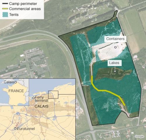
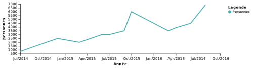
The above map, designed just before authorities proposed to clear the southern half of the camp settlements in early 2016, that they described as a “humanitarian project,” or “soft demolition,” sought to defuse the growing political debates and to restrain the already growing number of migrants who had arrived at the port town seeking passage, which they hoped to limit to 2,000–even as the numbers present were already above 5,500 according to the humanitarian organization Help Refugees–the difficulty to put faces on the many people who came to crowd the densely populated tent-camps was clear in the attempts to provide some humanitarian aid, balanced with fear of become a magnet for further refugees as the size of the Jungle settlement grew. While French police control the region and sought to prevent migrants from reaching transit by car or ship, and cleared tents and shacks from many areas, authorities opened a shelter in the camp’s northeastern region, adding 125 repurposed metal shipping containers to offer shelter for 1,5000 migrants as temporary housing atop the port’s sandy dunes. Many migrants rejected the sparse living conditions, but the multi-ethnic camps grew, nourishing hopes of future resettlement. Rather mapping migrants as outsiders who had only recently crossed the borders and boundaries of Europe, many of those who had arrived in The Jungle were seeking to rejoin relatives or former migrants who were already living and established in Europe.
 INFOGRAPHIE. L’explosion du nombre de migrants à Calais en un graphique (2016)
Similar encampments had appeared at Calais since 2003, and had been present since the late 1990s in some form, but the Jungle dates from early Spring, 2015, when it emerged as a destination and point of departure. But their recent ballooning provoked the forceful dismantling of the structures, as if to erase any trace beside the repurposed shipping containers brought to house migrants. And as it grew, it became an increasing concern of French citizens near Calais, giving rise to anti-immigrant sentiments, barbed wire electrified fences along freeways and around the entrance to the Eurotunnel, and something of a national political football and deep source of embarrassment to the government, providing evidence of their inability to process immigrants arriving from Africa and the Middle East.
The increased attraction of migrants to Calais is particularly curious as it represents the arrival of the disenfranchised communities of the world at on e of the highest concentrations of international capital. Indeed, the increasing number of migrants attracted by the highly profitable Eurotunnel, which runs the tunnel as a concession through 2086, or of 90+ years, which already turned an unimagined annual profit of €100. The concessioning of the tunnel has encouraged the outsourcing of monitoring of human traffic or transport across the tunnel–imagined only as a route of moving goods–to a private security firm of 300, a non-state army that is now headed by an ex-police chief and ex-army colonel, and has assiduously worked to install an array of surveillance and security technologies to prevent the smooth business of trade across the Channel, as the profitable chunnel works to reduce its €4 billion debt, even after having had a record year in 2015 in transnational trade, and is desperate to prevent the “problem” of migrants who have been based in Calais to reduce its income from freight and the Eurostar. The range of security forces and companies implicated in Calais border violence–supra-national entities such as Trascor; Vinci; Logistic Solutions; Jackson’s Fencing; Mondial Protection; L3; Clearview Communications for biometrics–reveal a congestion of commerce and wealth beside the world’s destitute that creates a bizarre hybrid space on the edge of the national border.


