
It is hardly a coincidence that the American Petroleum Institute first concentrations asked Trump’s administration to “re-examine the role and purpose of the Antiquities Act,” in a way that targeted the legislation that Obama had used. Rather than change the purpose of the Act, however, the Trump administration has sought to evacuate its meaning. Indeed, and ignore the preservation of sites of cultural wealth or significant. Indeed, the Secretary of the Interior seems to have replaced existing maps of the monument with the map of the infamous “energy zone” presented to the Utah legislature in 2015 that encouraged the Utah Bureau of Land Management to auction off parts of the region–a very broad brushstrokes data visualization, more suggestive of a buried treasure map, that entices the viewer by adding a layer colored suggestively in gold above the green topographic map of the region, which effectively superimposed economic over ecological rationales. Such a proposal was indeed a thorn in the side of the plan that local stakeholders sought to work out between 2013-15 in the potentially flawed Public Lands Initiative, but sought to start a legislative runaround to foreclose its role in the administration of public lands.
Energy Zone created by Utah Legislature in 2015, via Friends of Cedar Mesa
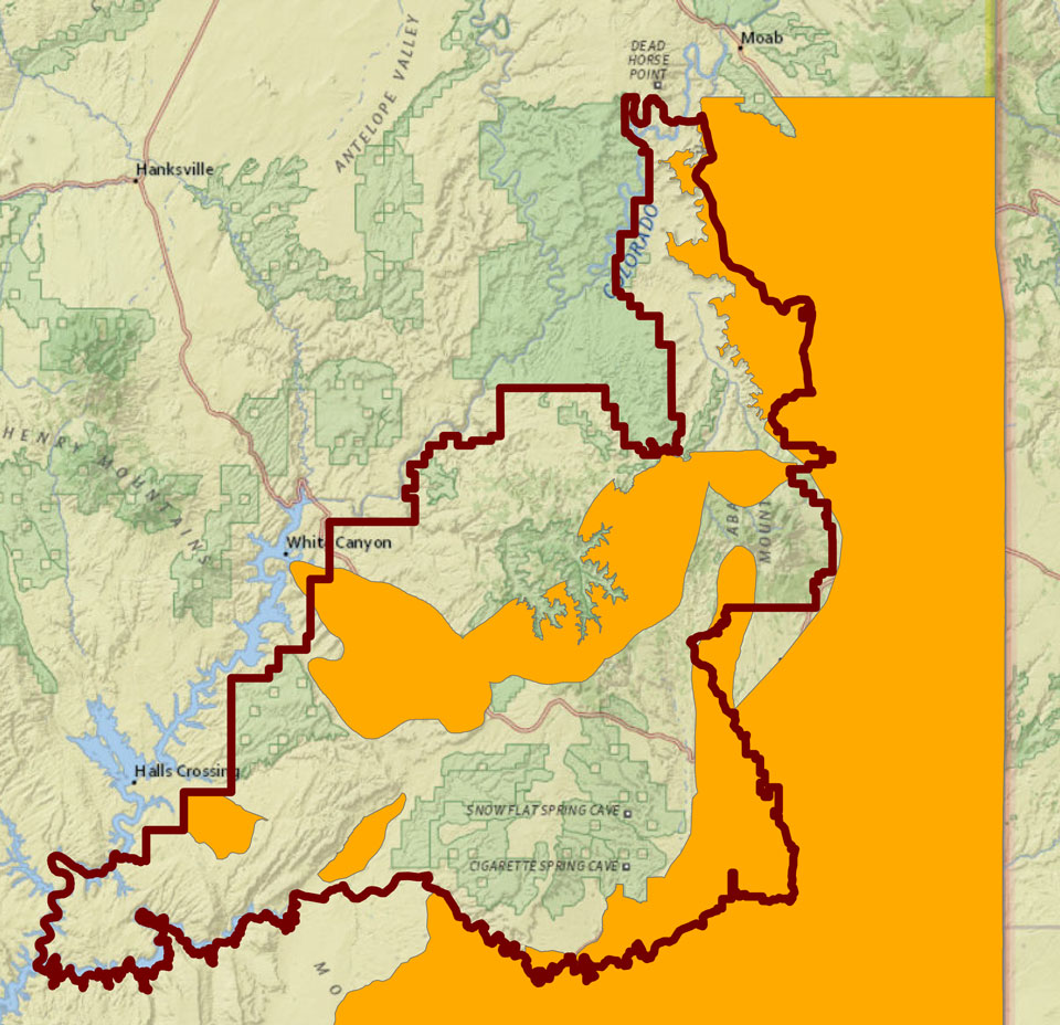
4. The map is an adequate metaphor of the blinders that the interests of extractive industries to target federal lands–and the Bears Ears monument–to access to what lies under it. Was existing GPS mapping of points of particular energy significance by companies who have auctioned claims from the Utah Bureau of Land Management the very basis for leaked maps from the Trump administration, whose curious form and the precision of whose UTM projection seem the fingerprints of existing interests of extractive industries? Were the plans for future prospecting and exploration by extractive industries the basis for the redrawing of the perimeter of the National Monument as two plots, removed from the sites of the greatest interest in energy exploration? The shrinking of the National Monument certainly suggests the prioritization of energy interests above the local cultural landscape. To be sure, the imposition of the layer of gold obscures the complex tapestry of claims of ownership in the Bears Ears monument–and the deep confusion between a clear dominance in the overall picture of native claims, marked in lavender, in and around the 2,112 sq. mile area of Bears Ears from the claims to oil and gas development and coal and uranium mines near the park, that seem to have catapulted it to the attention of the Trump administration and Secretary Zinke, and led the entire congressional delegation of the state of Utah to oppose the designation of the National Monument.
Inside Energy: sources include gis.utah.gov; BLM
To be sure, the maps prepared by extractive industries suggest the unprecedented scale of landscape modification at stake. For in defining the remapping of the lands as protected parcels, to prevent future disturbance or excavation, the act brought them into federal jurisdiction: rather than “governmental over-reach” infringing on “local” claims to land use, the clear desires of accessing what lies in the ground–as the coal fields that lie beneath the Grand Staircase Escalante–of which USGS had already determined some 11.4 billion tons were defined as able to be removed. If the preservation of the National Monument protected these mapped deposits from being accessed, the anger that they’ve created among extractive industries who have long lobbied for access to them, and recently heightened their efforts: the review of monuments was pushed heavily by Energy Fuel Resources, the uranium company, even though the price of uranium is far below what would make the mine profitable and coal mining would devastate the region’s pristine integrity, and most probably create it as a series of Superfund sites.

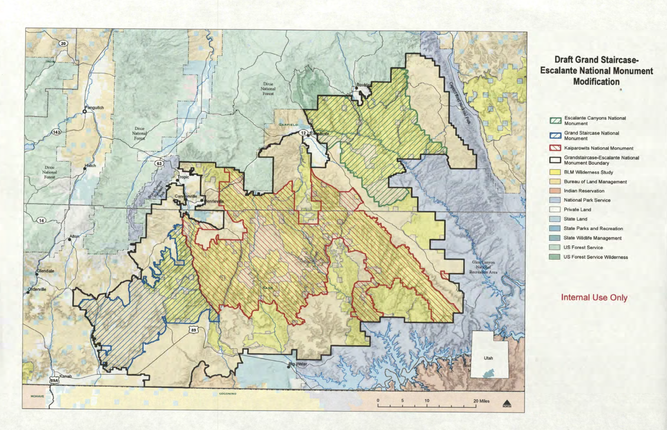 Proposed Reduction of the Grand Staircase-Escalante National Monument
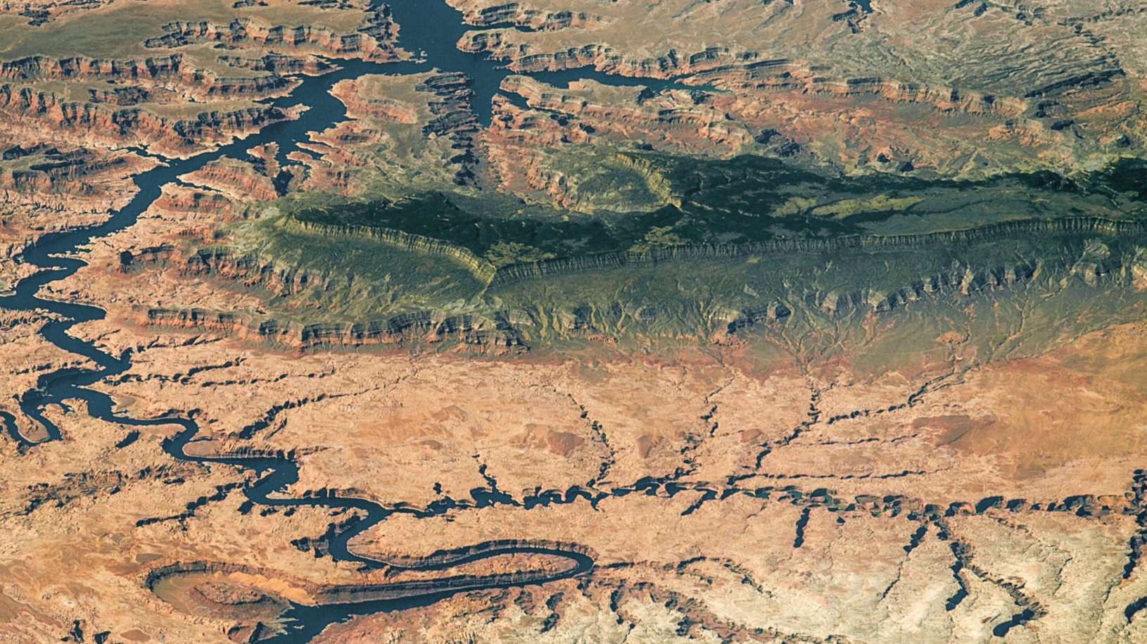
NASA, image of Grand Staircase-Escalante
1. Did not the unprecedented reclassification of the National Monument in fact represent an extension of claims to injure–if not destroy–the integrity of public lands? For while the rhetoric of liberation was used to describe the proposed redrawing of the National Monument’s boundaries, the new boundaries on Bears Ears seemed drawn only to allow increased access to underground mineral deposits and veins of coal. Indeed, the cursory shrinkage of this monument, redrawn from Washington, D.C. by the Department of the Interior with little consultation on the ground, save from the Utah Senators who were angered by the declaration of the monument during President Obama’s final term in office, removed many of the more precious archeological sites and sacred places on federal lands, and exposes them to potential leasing in ways that speaks volumes to two different visions of the relation of the office of the President to the land, if not the imposition of a form of GPS mapping, conducted offsite, without any actual assessment-as none has been completed–of the cultural resources in the declared National Monument.
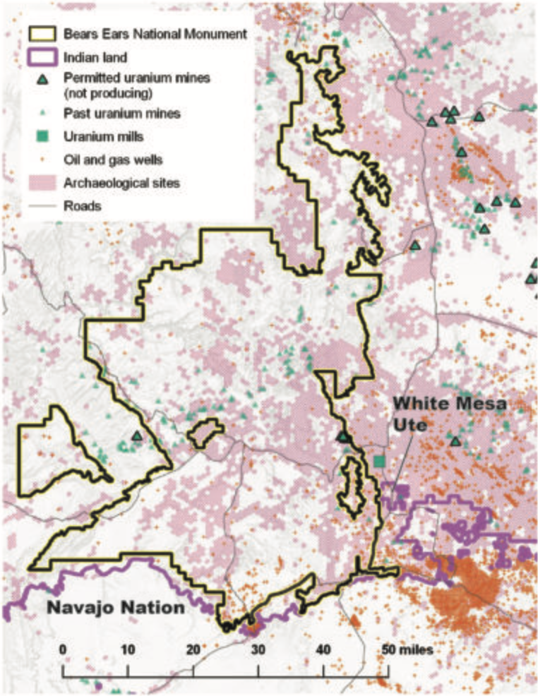
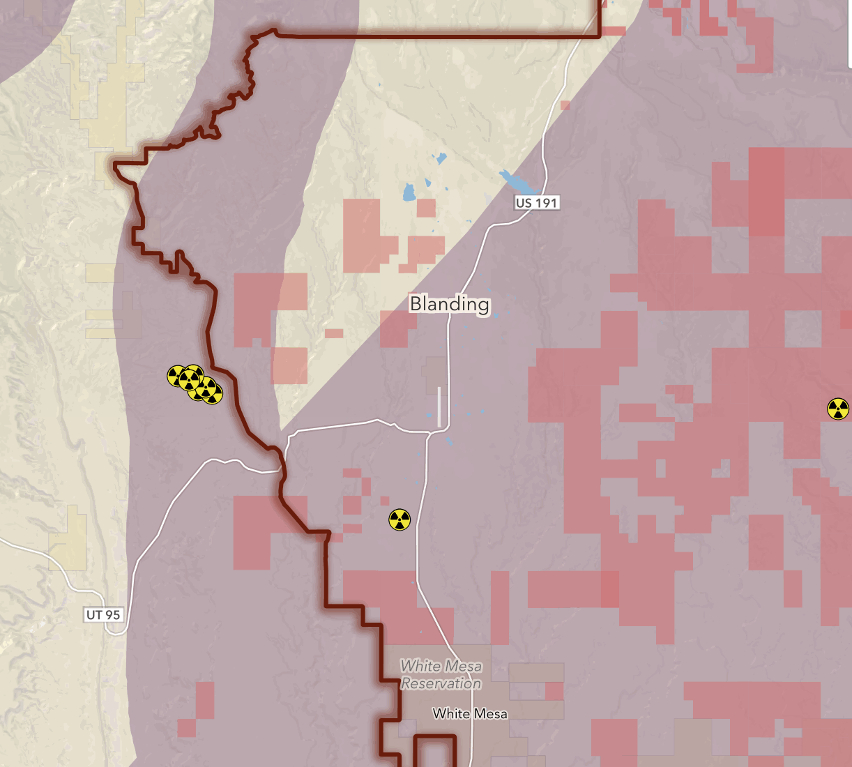
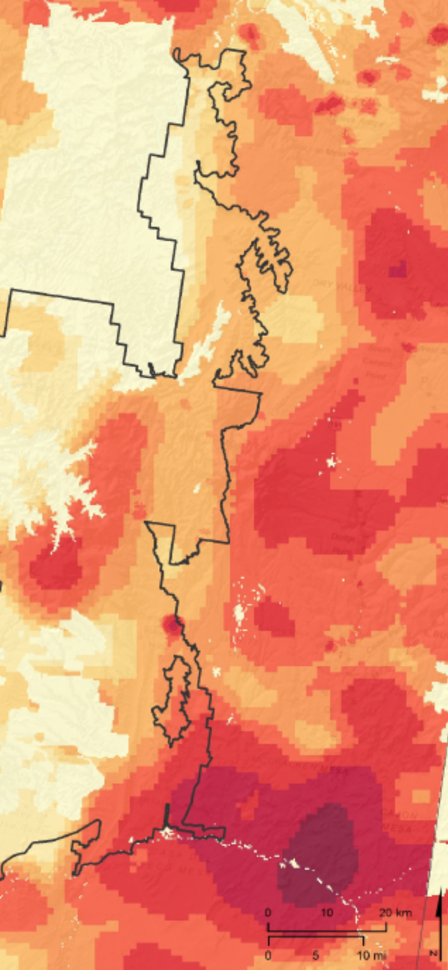
Despite the rhetorical power of these maps, printed in The New York Times, the startling omission of the private interests of energy companies and extractive industries fail to provide a sense of the clear motivations behind the rapidly announced reduction of protected federal lands, and fail to map the future that we can expect the arrival of extractive industries eager to expand their operations into leased lands around the former National Monument. Indeed the acquisition of future oil fields, sites for uranium mining, and sites for coal mining, all leased by the Utah Bureau of Land Management, as well as seismic studies for future oil wells, stand as a nefarious proxy for the “local interests” that Zinke and Trump evoke. suggest that an intensive mapping of the area that the restricted boundaries of Bears Ears and the Escalante directly correspond–and the distance of these maps from knowledge of the site’s cultural legacies. Indeed, the shrunken “revised” boundaries would take pronounced bites out of the wilderness regions but also the eastern side of the Monument, to expose the Dark Canyon Wilderness to through traffic, including transportation of uranium to the White Mesa uranium mill on the former National Monument’s boundary.

The huge reduction proposed to shift the levels of protection accorded the region is a blatant rewriting of land management policies, attacking what had been accepted as a new standard of local involvement with federal land conservation agencies. As much as provide a way to open coal veins to mining in close proximity to–and indeed within the footprint of the National Monument–they stand to allow the mining of fuels for the hauling of uranium across the monument to the White Mesa Mill which lies just six miles outside the monument, in the town of Blanding, Utah–where activity stands to expand simultaneously to uranium mining in nearby former Grand Staircase-Escalatnte National Monument. The seven mines just inside the former boundaries of the Bears Ears national monument would be ready to function–and the reduced National Monuments would allow easy ground transportation through the former monument on roads, to transport leased oil and gas
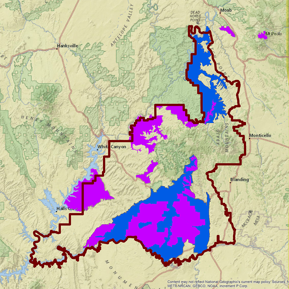
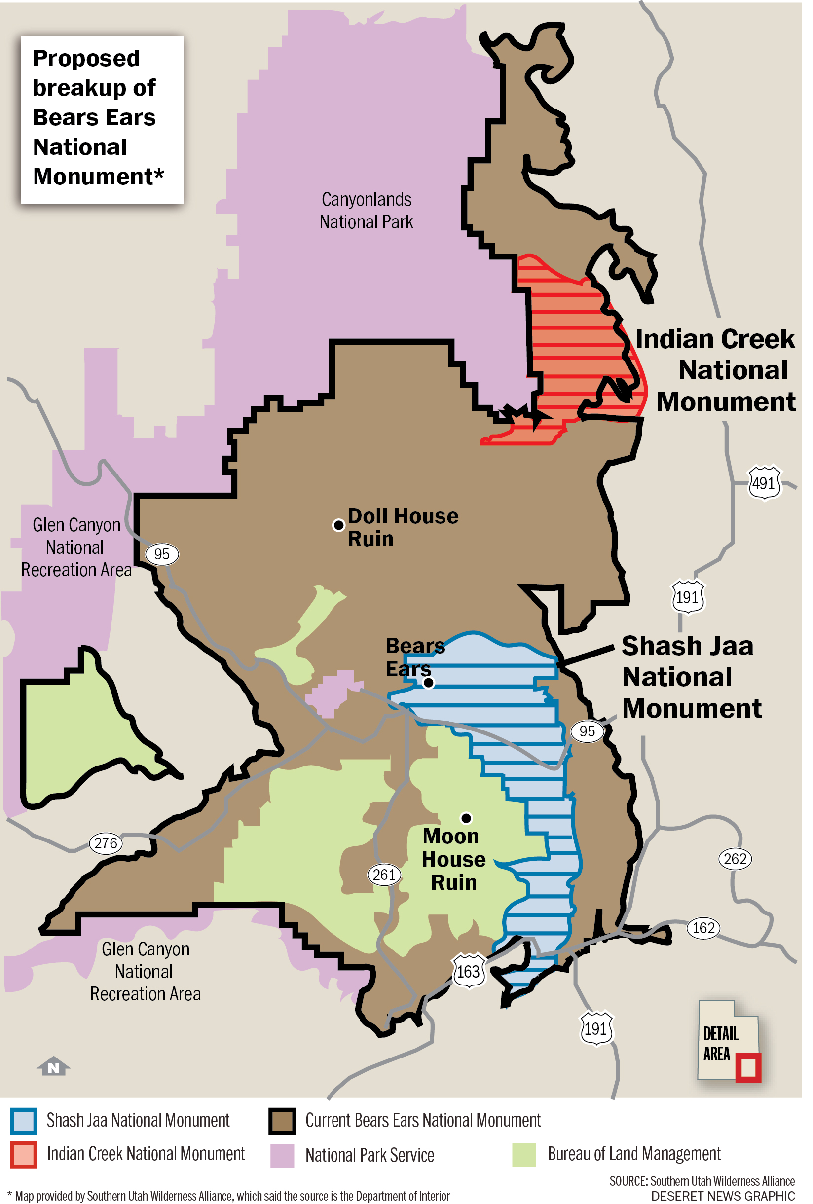
The proposed clipping of Bears Ears to a vestigial “units” of the buttes and one rock ridge would invite the reconsideration of leasing other lands, in ways that are indeed far more circumscribed than the Public Lands Initiative which preserved National Conservation Areas (shown in blue) and wilderness areas (shown in purple) within the Bears Ears National Monument.

National Geographic
5. But the redrawing of boundaries supersede agreements to protect the lands in a collaborative manner with Navajo and Ute Mountain Ute tribes, and indeed vacates their voice, as well as not incorporating lands rich which symbolic and archeological significance. In critical ways, the rapid redrawing of boundaries appear to have been drafted with little attention to the demands of landscape management, interests of local tribes, or the geographical integrity of the site or of its cultural and historical status. For the proposal would break up the historical unity of the monument that was created by the last Presidential administration definitively; the move to strip the lands of their designation as a national monument undoes the unprecedented recognition of the lands’ value that extend beyond historical or archeological reasons, but ignores its historical significance for native peoples who have long regarded it as a spiritual home, and leave much of the formerly protected lands newly vulnerable.
The proposed remapping of its boundaries undoes its integrity, by opening areas of the National Monument as property that the government can lease, undermining its cultural and historical value in ways that sets a precedent of reclassification that stands to threaten all public lands–as they stake a challenge to redraw the boundaries of federal lands to facilitate their leasing in ways that would forever compromise local landscapes. Indeed, the UTM projection that proposed to dismember Bears Ears as a monument was drafted offsite, in Washington, DC, with attention to the recent 2017 evaluations of the density of mining resources within and on the side of the current National Monument—-as if to prepare for mining claims in the wilderness preserve, from the American Petroleum Institute, Energy Fuel Resources, and energy corporations like Kirkwood Oil and Gas, who leased areas near the monument from 2013, and the Wyoming firm Hoover & Stacy, who have leased four parcels in Bears Ears in 2015 from the Utah Bureau of Land Management, lying just outside the Monument–and other energy companies who have requested leases on or near the same public land. (Kirkwood long chafed under the Obama era regulations against methane leaks; Energy Fuel Resources is eager to expand production and urging the rolling back of mining moratoria, after Obama Interior Secretary Salazar stopped uranium mining in the Grand Canyon in 2012; Hoover & Stacy have made over twenty bids on public lands in Utah and Wyoming, as have Kirkwood in Nevada and Wyoming.

6. Such a broad evacuation of the monument’s designation would rob it of its historical and archeological as well as its deep significance and shared cultural meaning as a place, denying what was long understood as unique. Indeed, the very GPS tools used to remap the boundaries of the monumentsparadoxically works to erase any sense of their historical or cultural value, treating their boundaries as land parcels stripped of cultural or historical value. The very tools of GPS help to trump local knowledge, and indeed to impose a new design on a landscape filled with archeological ruins and significance, whose survival is deeply tied to its remove from development, The mapping of new boundaries will break up a complex territory.
For by remapping a region filled with historical markers of its inhabitation, and recognition of its spectacular majesty, the redesignation of Bears Ears would fundamentally and irrevocably change it as a place–and treat it as yet another fungible parcel of property by a President who seems to understand his role as Realtor in Chief. President Obama’s recent but timely designation of the National Monument as a national monument raised the level of land management and standards of preservation of the area around Bears Ears for future generations. In preserving a cluster of lands of deep historical and spiritual experience, the declaration reflected consideration of the density of ruins as worthy of protection of historical and scientific interest has provoked calls for retiring the Antiquities Act. and President Donald J. Trump seems intent to grant entry into archeological sites and recreational spots, and indeed on giving away a historic and very delicate part of the western landscape: indeed, by remapping the same parcels recently status by public proclamation as parcels to be readily leased, and open to excavation in ways that will disturb their historical fabric. Although courts have resisted any “prob[ing] the reasoning which underlies” designating national monuments as a form of intruding on executive decisions or the legislative process, the invitation that Donald Trump made to his Secretary of Interior, Ryan Zinke, to remap federal lands as public properties reveals an overreach from Washington using GPS serves to shift judgement of the value of federal lands from their historical or cultural grounds.
 Alex Goodlett for The New York Times

Leaflet | qgis2web, © OpenStreetMap contributors,CC-BY-SA
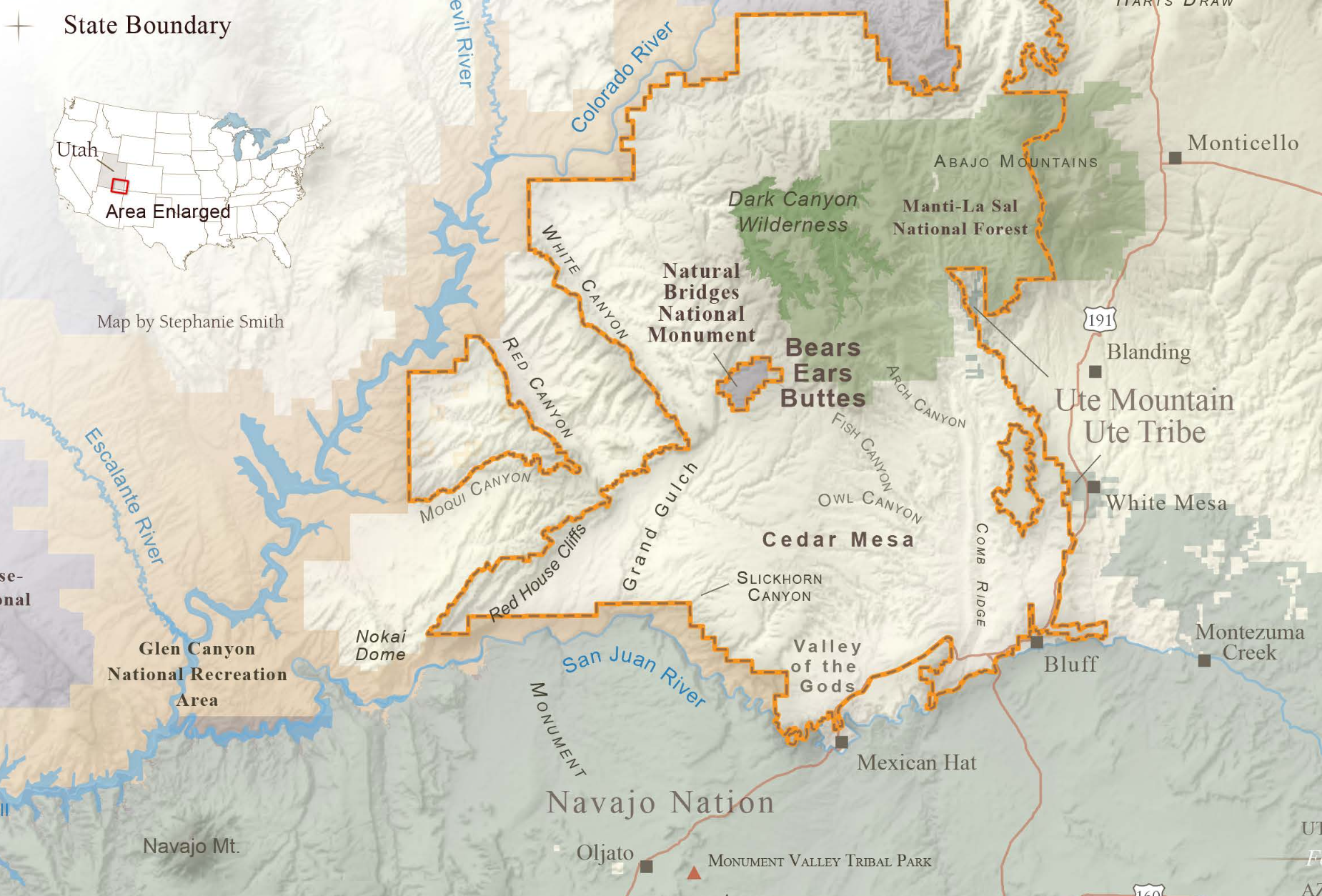
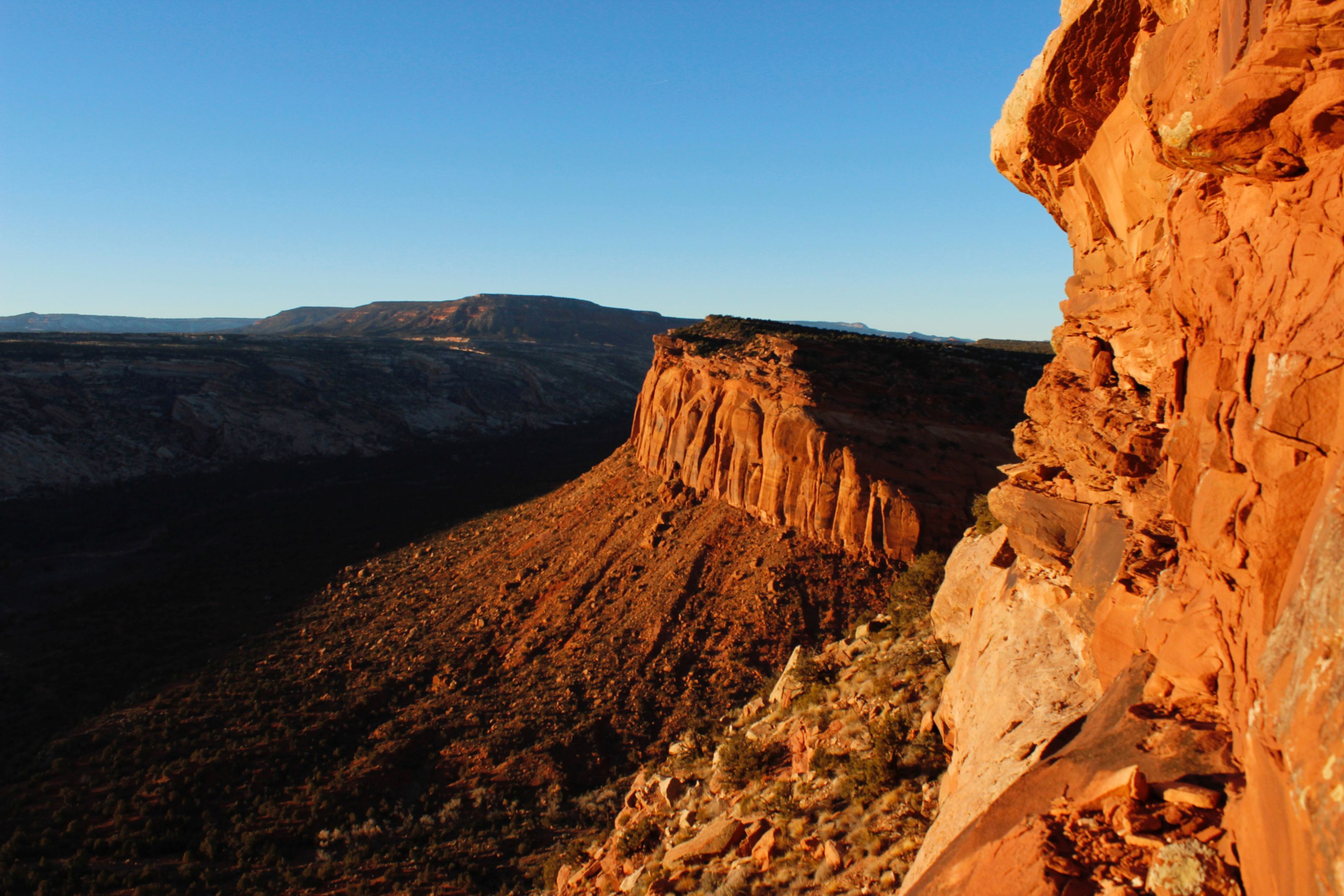
Is there a way that the very mapping tools used to revise such monuments’ boundaries works to remove them from grounds for judging their historical value or legacy? By aggressively reducing the borders of the former National Monument, lined below in black, carving two small patches of quite unnatural compact size out of a broad complex. While the monument is closely located nearby the Canyons of the Ancients, Mesa Verde National Park, and San Juan National Forest. Increasingly, and even at a short distance of time, the threatened loss of Bears Ears seems not only a desecration of the commons, but a metonym for the abandonment of public lands to private interests, and the break-up of a contiguous set of public lands that was once defined by the scale of its integrity–the National Monument was among the top 10% of regions of such size in the West for ecological intactness and connectivity, and the severing of its regions into two separate monuments will not only decrease their monumentality.
But it will also definitively compromise their unique value as a coherent historical landscape: the break-up will challenge both the landscape conservation of the region that has been achieved, and the biodiversity of an especially fragile ecosystem. This is not only about monuments, but about rewriting the landscape. The arrival of any sort of industry in an area which was classified as being in the upper 4% of global stellar visibility in an ever-brightening world. The extremely low light pollution would be irreversibly compromised by the arrival of industry–as environmental pollution and even levels of radioactive dust–would compromise the historical setting. While the region’s status as a National Monument is cast as a dodge for environmental regulation within its boundaries, the adjustment of these boundaries exposes it to untold pollution. Might we consider the need to redefine the meaning of a National Monument to include a broader compass and more ethical standards of land management than when it was framed in 1906–by standards taking into account new environmental stresses that extractive mining or strip mining place on historical lands–rather than fetishizing the isolated points?
7. The extent such an unprecedented act of reducing a National Monument cannot be counted in acreage, or even made visible on a map. For it stands to entire rewrite the landscape and the ecosystem of which it is part in ways that we cannot fully measure, as we are essentially inviting development up to the limits of the current proposed boundaries–even permitting the leasing of land between the two rumps of the Bear Ears National Monument that now stands. Indeed, the ability to map at a remove of its landscape–despite Secretary Zinke’s earlier promise to visit the region–suggests a sort of blind mapping, at a remove of the landscape, of the sort that GPS can allow, and transforms the status of a National Monument–a designation that is quite thought out and was explained in detail when it occurred–as a fungible piece of realty in ways we could only be able to expect from Donald Trump’s Presidency. The prospect of opening the ecologically intact region to leasing would end the environment–the character–of the place which was declared a National Monument, and not only awe-inspiring but sacred to many, as well as a site of historical inhabitation whose wealth demands to be defended by the government–not squandered. The proposed restriction of the monument to vestigial outposts robs it of not only of archeological sites in need of preservation under the guise of “restoring” it to states, but revises claims to preserve the common or historical area of the monument. The unclear status of the Wilderness Areas that had once expanded beyond the National Monument of Natural Bridges over a broad area is no longer permanently protected; the vestiges would be far removed from the headwaters of the Colorado River, and set a dangerous precedent for altering land management policies in complex ways for unstated reasons, but whose exposure of coal veins and future possibilities of prospecting will damage its integrity in due time.
Donald Trump famously enjoys thinking in terms of monuments and monumentalization, and even hopes that the proposed Border Wall between the United States and Mexico might be named after him. The reclassification of the national monument had never been attempted, even by a President; the request to review the status of national monuments recently designated by the Antiquities Act we perhaps had better taken stock of the potential consequences of requesting such a review, as it seemed to elevate the power of the Secretary of the Interior to undertake a housekeeping of lands named by Presidential authority that had been characterized polemically as “land grabs” of unilateral nature, denigrating the motivations behind their designation outside of any process of review that would not be interior to the executive–or able to be accomplished by an executive order, Trump’s favored means of public communication.
Such unprecedented revoking or the status of a monument in quintessential Trumpian fashion. For not only does the practice remove cultural wealth and natural beauty from protection, but erases their preservation as a region next to adjacent Navajo lands, often not even noted on most maps of Bears Ears. The precedent that this offers for actually revising the boundaries of National Monuments–as if this were a means of keeping house–disguises the reconfiguration of a territory that was designated to be preserved for its unalienable value to the nation, and converts it to real estate that might be leased to the greatest bidder, and whose underlying mineral or gas resources are sufficient to lead us to a path of greater energy independence.
Bears Ears Coalition, using data from Utah Bureau of Land Management
Remapping the delicate complex system of ruins by 202,000 acres so radically might be best understood as a breakup than a simply “revising”their boundaries–the intentionally vague recommendations Zinke issued as recommendations for the future of six national monuments in the early fall that stand to alter practices of land conservation in the American West. Indeed, by removing the Cedar Mesa and Elk Ridge landscapes from the status of a national monument, the landscape will no longer be coherent.
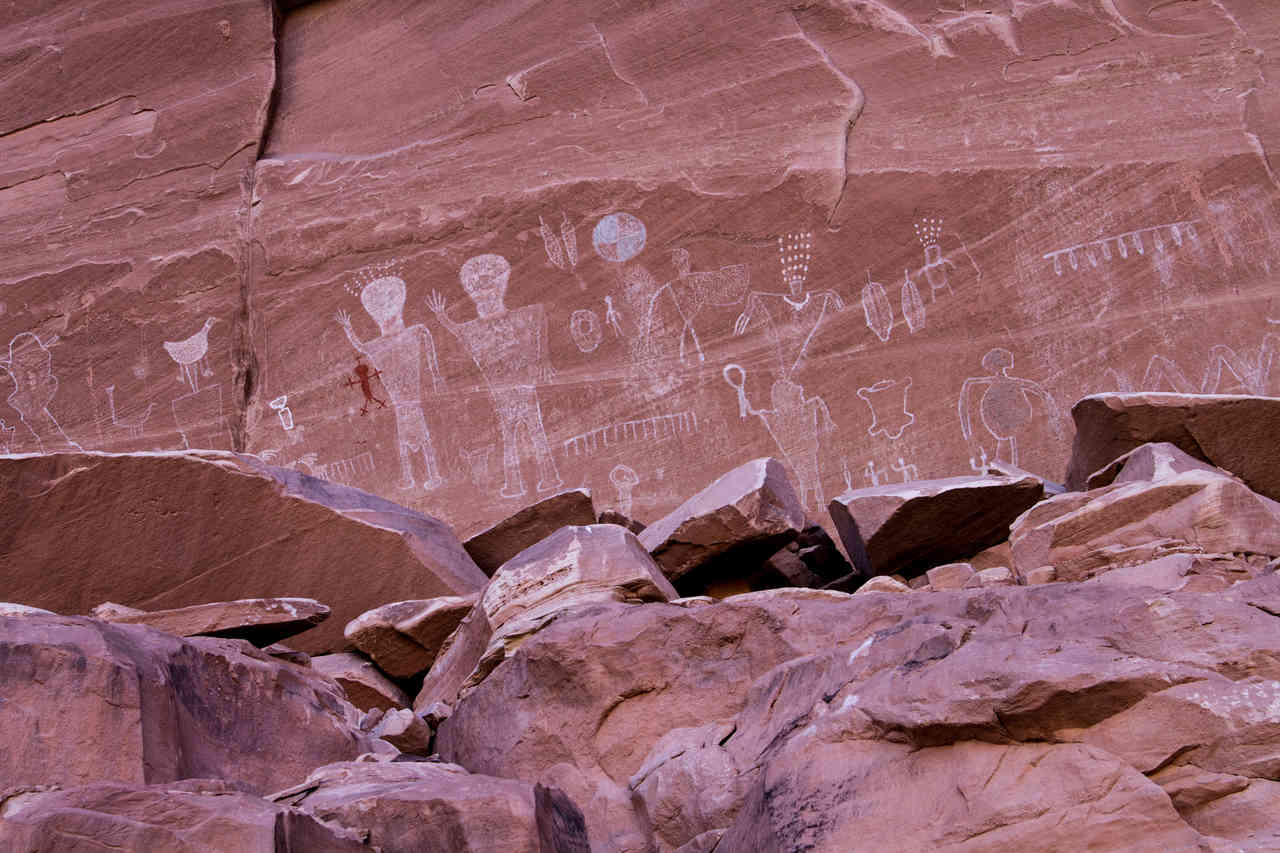
Those regions subject to robbery, theft and looting each year, per the Native American Rights Fund, will once again be exposed to vandalism, and lack integrity within a particularly delicate landscape and ecosystem. The recent concentration on a single Navajo claim–using the Navajo name for Bears Ears–Shash Jaa–includes the impressive Bears Ears Buttes themselves, parts of the Mule and Arch canyons, and the Doll House and Moon House ruins–previously been designated monuments but which Obama had singled out for preservation as sites of “objects of historic and scientific interest”–and the very oldest archeological site in Utah, but excluding the region known as Valley of the Gods, Glen Canyon, in radically disjoined regions that seemed mapped by satellite in Washington. Despite the new names for the areas accorded monumental status, the exposure of the adjoining lands to prospecting and extraction–opening former mines, expanding the traffic from coal and uranium mines to stations near the park where they can be purified, and perhaps the construction of a pipeline through the former park–are certain to generate considerable atmospheric pollution. In a bizarre rewriting of the fate of the benefits that the Osage nation’s gains from oil on their reservations, which produced more wealth than all gold rushes combined, and led to the Indian Territory Illuminating Oil Company, until it lost its right in 1916, native nations will be prevented by the Bureau of Land Management from benefiting from their proximity to mineral wealth and oil, although they will suffer its intrusion.
Anasazi grinding rock in canyon along Elk Ridge included in Bears Ears National Monument, proposed to be managed by USFS (Al Hartmann/Salt Lake City Tribune)
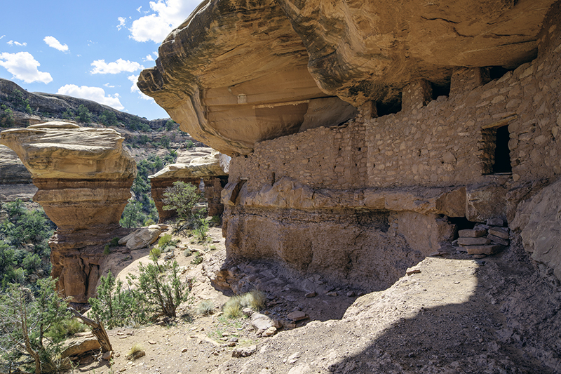
The Moon House Ruins in Bears Ears, to be given to the Bureau of Land Management
The ruggedness of the lands here is not clear from the map, but few familiar with the site can make sense of its new divisions as a monument, which rather than connect sites and spaces break up a formerly integrated unit of land management, using tools of mapping that seem to take pleasure in opening up the largest possible land for leasing. Even if there aren’t reported gas and oil resources in Bears Ears, the cutting up of the monument would set a precedent for relinquishing responsibility of land management and seems designed to allow the expansion of exploration of the Plateaux’s coal seams, evident in the significant regions proposed to be demoted from monumental status.
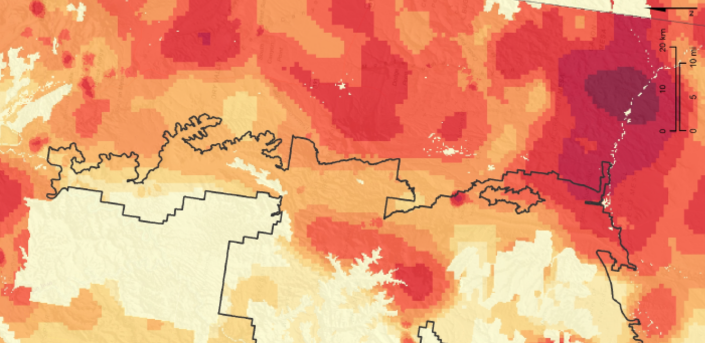
The evacuation of the status of a Monument was performed by a President acting as lord of the domain, or sole property owner of a region, even if the concept of land management was carefully refined over time. Indeed, it serves to place as much land on the market for future prospecting, under the presence of its liberation. The location of a considerable amount of the mineral resources, quite predictably, precisely between the two new, reduced monuments–and immediately outside the park. The high risks to mineral development–in the seventieth percentile of similarly sized regions of the American west–measures the almost magnetic attraction of the region to extractive industries was long known, but to suggest the deep dangers to the local ecosystem but potentially to the groundwater and headwaters of the Colorado River and Grand Canyon.

Center for American Progress (based on 2017 analysis)
–suggests exactly where such drilling will occur, and why the edges of the park are themselves eroded in irregular ways allow its mineral resources to be accessed. The resulting fragmentation of the lands’ boundaries will bring by the arrival of prospecting and an aggressive expansion of industry, in other words, and the irrevocable changing of the landscape as it now stands, suggesting not only a theft of land but an utter despoilment. The considerable concentration of resource potentials that are known both in the middle and on the eastern side of the National Monument–
–would only invite mining claims to arrive in an area whose coherence is preserved by its status as a National Monument–not a wilderness preserve. The density of such a mapping of potential resources in the same suggest the exact importance of creating such reduced national monuments focussed on areas of limited potential resources.
Indeed, the strong interest that extractive industries have shown in laying claim to the region, and their release from any obligation to give revenue from their prospecting to the state or nation, is mind-boggling as a give-away to special interests, as if Trump were readying to grant a Christmas present to the benefactor of his campaign or to the so that just outside of the newly proposed “Shash Jaa” Monument will be able to be sold and mined for coal, a deposit to which Trump’s ego and identity seems to have been closely tied: the leasing of lands for future extraction in the broken up National Monument will have been enabled by the exit from the Paris Accords, in other words, and seems designed to release greenhouse gasses in the long term, both from the coal mine methane released in the practice of mining, which has effects over twenty-fold more significant than carbon dioxide, as well as in the greenhouse gasses released in burning mined coal. The opening of the National Monument stands poised to be a gift to a coal industry that is not in itself money making, in other words, but which the Trump administration seems eager to subsidize by proposing the irrevocable give-away of a National Monument.
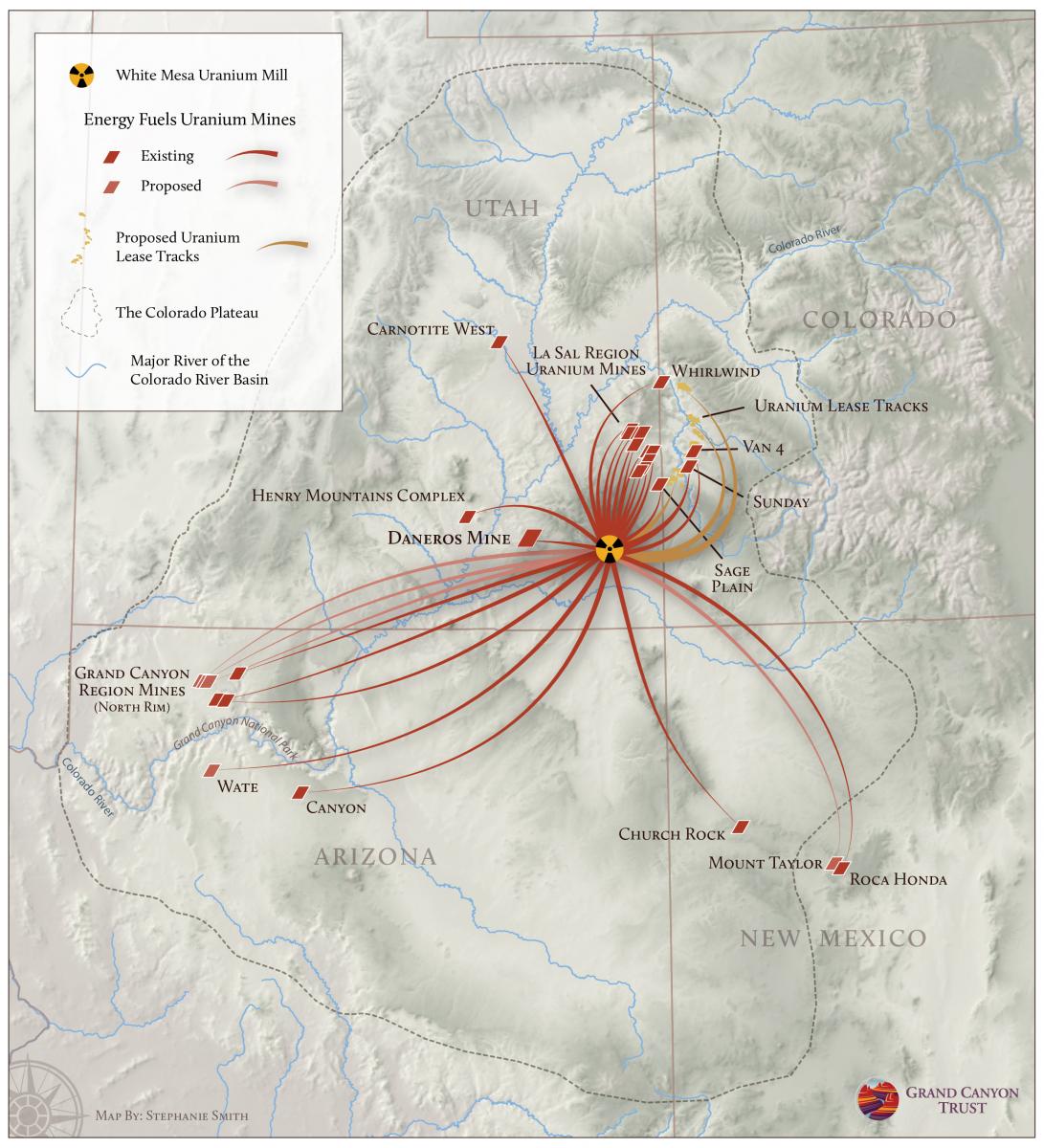
Although Zinke and Trump have both prepared a bucolic vision of the arrival of animal herders, the actual audience that stands to benefit from the redrawing of the boundaries of the monument is quite different, and far less local. Indeed, the clustering of old uranium mines around the targeted Bears Ears national monument, shifting from a data visualization to an image of former and proposed mines that would serve as sites to carry mined uranium to the White Mesa Uranium Mill, stand to disperse radioactive dust across the landscape, and constitute a veritable mini-industry of uranium production the stands to redefine the landscape of southeastern Utah around an energy market over much of the Colorado Plateau.
8. The expansion of Presidential authority to redraw federal lands, including canyons and gulches of astounding natural beauty, actual golden arches carved into the sandstone of the Colorado Plateau, including Anasazi areas in Elk Ridge, seems to undermine public lands protections. Giving the vestigial area a Navajo name seems to assign it importance only for one constituency–reducing the status of land protection to a question of balancing individual interests, rather than historical significance. It seems to follow suggestions of the Republican Senator Orrin Hatch, preserving prominent ruins as state monuments, but stands to reduce the remoteness as publicly protected lands, rewrite policies of federal land protection and open possibilities for their future parcelization, and the consequences that this would have on the region.
In claiming the role of a liberator who was able to roll back the limits of federally protected lands, under the legally dubious instrument of yet another executive order, President Trump staged the predesignation of Bears Ears as reduced perimeters of new “Shásh Jaa'” and “Indian Creek” monuments, quite misleadingly, as a defense of local interests. But presented as an action against the dangers big government, in a standard pitch of an old Republican party, it seems more like a land grab by Washington. Even if the declaration decidedly illuminates the increasingly transactional notion of the Trump presidency, shrinking the National Monument was cast as promoting needs of rural inhabitants, cleaving the nation yet again between the rural interior and coastal elites, in another Trump trope that has been returned to over the past year to portray him as a custodian of the common man. But rather than preserve these lands for grazing, pasture, or logging–industries that are not exactly booming, and would be pretty out of place in these arid plains. The targeting of Bears Ears cannot be seen as pure Trump, but reflect the earlier executive order that invited Interior Secretary Ryan Zinke to review all national monument of an area greater than 100,000 acres. It undoes the preservation of lands established during the previous four administration, in the name of hoping to “end these abuses and return control to the people, the people of all of the states, the people of the United States,” trying in any formulation to identify himself as a populist. But Zinke, eager to exploit hidden fossil fuel resources in national public lands that were placed off-limits since Teddy Roosevelt, has already gone further and proposed reducing two more National Monuments that are rich in mineral resources–Nevada’s Gold Butte and Oregon’s Cascade-Siskiyou–although the proposed reductions in these other national monuments is not public, perhaps until the trial balloon of Bears Ears is fully processed.
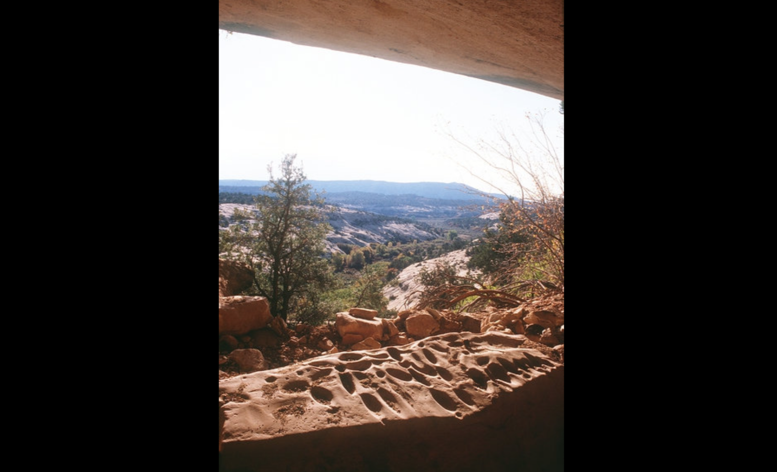
Zinke earlier came up with a group of choices of monuments to reduce, but Trump may well have chosen the first, relishing the poetic justice of and carefully manipulating the possibility of some public support for dismantling one of Obama’s final hopeful actions. In doing so, as has been observed, President Trump proudly jettisoned recommendations of the Public Land Initiative maps made in Utah that the state keep the entire Cedar Mesa–an area of land extremely rich with archeological ruins, and was farmed from as early as 500 BC by ancestral Puebloan community, and constituted the richest site of archeological exploration; the region is to be protected as a Wilderness Studies Area, but will be left increasingly vulnerable to pillaging as it lies between the two hived off sections of Bears Ears, and disrupts the exploration of its cultural continuity as a site of land use rich with remains of patterns of habitation through the mid-thirteenth century AD. However, with the impunity of a GPS scalpel, unable to register regional history, the question of the rich historical legacy of the lands was tabled by carving by unclear logic two isolated peaks as the sole vestiges tof what was once was championed as the legacy of the Obama presidency. Indeed, by isolating the two geological formation without the landscape of hidden canyons that surround the expansive area of preservation. In so doing, he has reduced whatever mandate of preservation Obama had bequeathed to one of far smaller scale, and discounted the heritage or cultural importance of the monument as a region and its historical legacy as well as a preserve of unquantifiable value. The recent discovery, for example, of fifteen perfectly preserved maize cobs 1,900-year-old, but kept in the dry desert cave in Utah, provided insights into the resilience with which tropical maize adapted to temperate growing conditions of high altitudes, almost two thousand years ago, before their agricultural adaptation, as their genomes could be sequenced, offering something of a portal for time travel to an earlier era to compare traits of corn an early stage of the domestication to modern strains of farmed corn. The disruption of an area would sacrifice a “three-dimensional data trove” for archeologists that preserved multiple otherwise easily perishable objects and artifacts–from feather blankets to baskets to cobs–in an entirely undeveloped landscape in an arid plateau like Cedar Mesa.
The breaking of the region into two units would fragment the actual intention and achievement of naming the National Monument. To do so runs against the original intent of naming the region a National Monument. Immediately after Obama declared his intent to use the Antiquities Act, Utah Senator Mike Lee had inveighed against the preservation of these land by executive fiat, which he argued overrode the will of the “people of Utah,” and revealed executive overreach. “This arrogant act by a lame duck president will not stand,” he claimed, vowing to “work tirelessly with Congress and the incoming Trump administration to honor the will of the people of Utah and undo this designation.” The rhetoric of undoing the designation of a monument, long in coming, was way overblown. During his confirmation hearings, Secretary Zinke, tried to give the appearance of tempering it when he assured Senators he would visit the monument at first hand, and would “talk to people on the ground” before he undertook to “make a recommendation to the President.” He famously rode a white horse to work on his first day, more for a photo op than to actually follow the preservationist agenda of Theodore Roosevelt. He seems to have come to the decision quite quickly.
Eliminating a region designated as a national monument is unprecedented, but was done so surgically that the landscape seems to have barely been taken into account. Despite the preservation of some of the most iconic parts of the monument in two monuments of enormously lesser size, there is no grander vision in the decision to preserve lands, as it only seeks to accommodate interests of industries that have no appreciation for the place or its contents: if the new boundaries would preserve the ancient petroglyphs on Newspaper Hill, they invite raiding of the most precious archeological sites, and show no concern for the canyons where the Navajo once, having been driven from native lands at the end of the Civil War on forced marches in 1864-5 as the US Government forcibly displaced 8-9,000 far from the lands that they had historically occupied, took refuge. The forced march across over 3,000 miles granted the area deep status as a refuge. It is tragic that the proposed lines of the monuments reduction drawn by GPS advance interests that would shrink a region rich with of prehistoric ruins by 85%, endangering in situ petroglyphs in Newspaper Rock that stand to be mapped in the reduced monument proposed to be renamed “Indian Creek”–but excluding areas of majestic sheer rock, sandstone gullies, and canyons, as well as sites of immeasurable historical and archeological value.
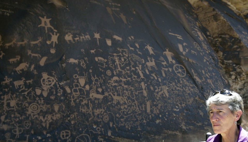
Interior Secretary Sally Jewel in Bears Ears, 2016
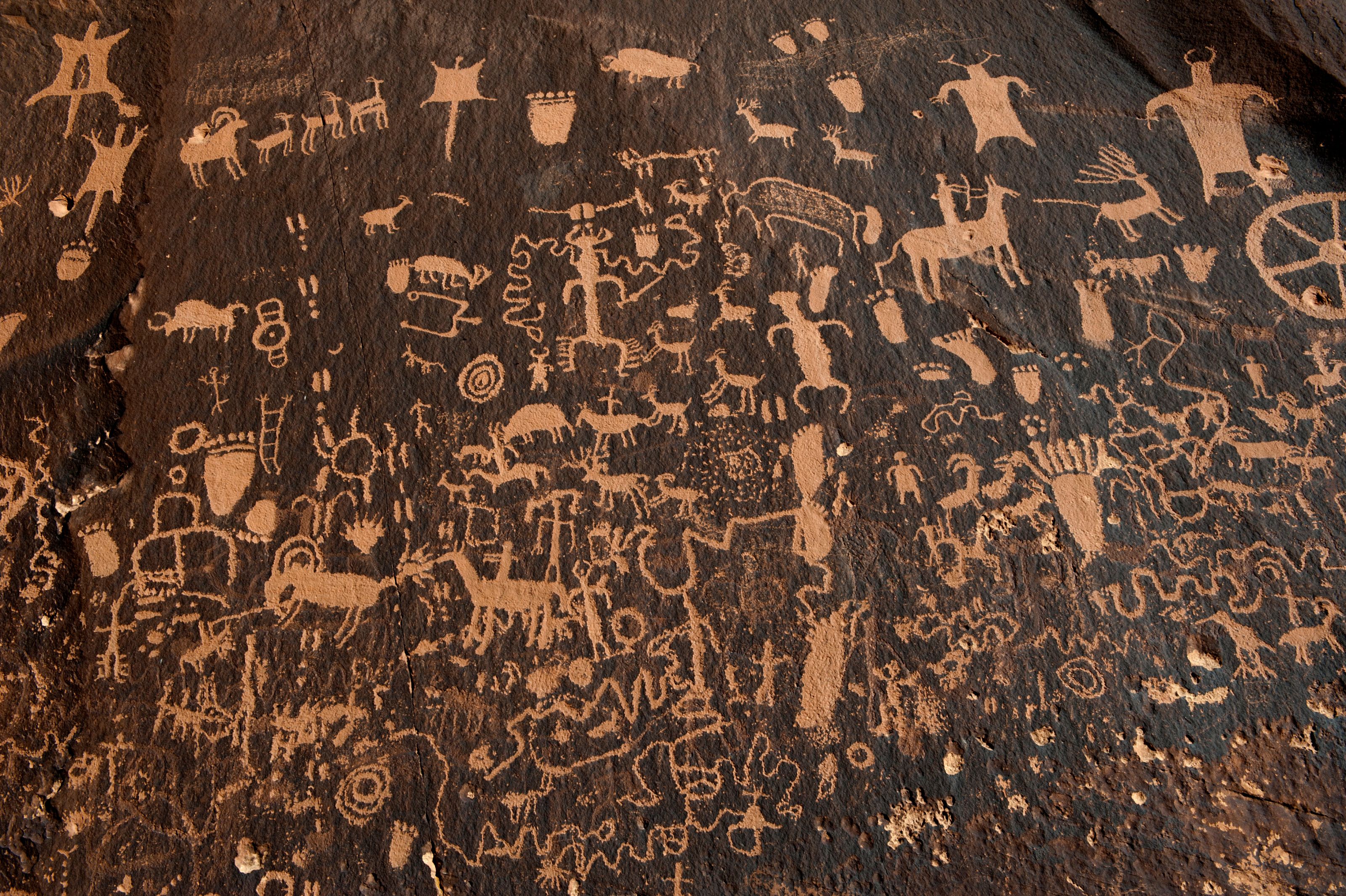
Among those sites proposed to be removed from monumental designation are, for some reason, the pictographs at Grand Gulch.
The drastic plans to shrink the monument seems to have suitably Trumpian proportions–as if it was part of a massive downsizing project, using tools of mapping to perform the sort of theatrical de-monumentalization of the sort that a Donald J. Trump must take a particular obscene pleasure–and not only to gloat over his predecessors’ cultural legacies, and to deny them the status of making monument that is bequeathed on Presidents, and to reserve the right to make two far smaller monuments, now renamed . But if the goal is to demonize big government and regulation, Bears Ears may be but the case in point, as it threatens to shift much of the area’s land-use designation, and effectively open it to potential prospecting, as the designation of Areas of Critical Environmental Concern are open for review, and Wilderness Study Areas may be stripped of protection by Congress at any time. The new ability to act on leased claimes in the area deemed worthy of preservation and historical and sacred value–the Valley of the Gods, and the canyons of the region’s unique landscape, served to radically reduce the scale of contiguously protected lands whose odd boundary modification opens sites for looting, pillaging, and theft by disregarding their historical and spiritual legacy. Is the appropriation of lands a final culmination of disenfranchisement of the native tribes who have worked systematically for so long to preserve the region rich with specific memories, in ways that fail to register in GPS maps that focus on its mineral resources?
Indeed the failure to appreciate the danger of increasing vehicular access, road traffic, and industry at the sites for future coal and mineral mines in the region will transform the landscape immediately adjacent not only to Native Lands, but National Parks and Wilderness areas whose level of pollution is now all but destined to escalate rapidly in coming years, as multiple extractive industries relocate to leased lots in the region.


Daniel, you should send this to the New York Times Opinion editors.
Cheryl Koehler / Edible East Bay
Subscribe online at http://www.edibleeastbay.com Sign up for our e-newsletter here: http://eepurl.com/z-fkn Visit our advertisers to find your complimentary copy: http://edibleeastbay.com/find-a-copy
>
It seems on the long side, but thanks! Please feel free to circulate, Cheryl