
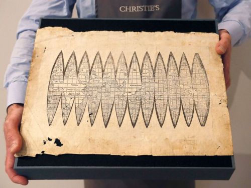
The appeal that was exercised by a newly discovered set of gores that arrived at Christie’s announced was considerable. The map constituted one of the first mappings to show the place of America on the globe–and indeed to map the globe as a globe. The considerable attention that the gores slated to go to auction in mid-December attracted must have lain not only in their rarity, but the cult of priority of the naming of place. The gores exemplified the declarative role of mapping to designate place, as well as a geometric organization of global continuity shortly after the discovery of the new world, but it was hard to imagine that the appeal of the gores in our increasingly pixelated, pointillistic, and fragmented mediated sense of space was not in the solidity with which they seemed to embody “America,” both on the map and on a globe.
The gores were highly valued as the first image that mapped America–and assigned it a name–whose almost cultic prestige had grown allowed viewers view a watery western hemisphere, since described by antiquarians as the “birth certificate” of America, in an ahistorical but nineteenth-century fashion, for bestowing the name of the European navigator Vespucci on the continent that he had described in a set of letters that widely circulated in Europe from 1503, and provided a written account that oriented readers to to the New World, describing a vicarious sort of witnessing the unknown that expanded the demand for global maps as they were widely reprinted. Amerigo Vespucci described the long shorelines of a New World that allowed a distinctively modern way to view a rapidly expanded image of the inhabited world, and allowed Waldseemüller–even if the humanist cosmographer who had trained as a theologian rarely travelled beyond his town of St. Die, near Strasbourg, but exploited the printing press to reconcile Vespucci’s findings with precepts of map projection derived from cutting edge cartographic tools. And when he adopted the format of the mathematician Apian to render the world on gores, he used the graphic techniques of projection to lend solidity to the first narrations of the New World. So it was quite surprising that the forged copy of gores that almost made it to auction in 2017 belonged to the same visual culture of online images–the culture of image capture and digital reproductions–as what seemed a worm-eaten sheet of printed paper was found to be created by tools of digital photographic reproduction, with little human trace of an engraver’s hand, although they seemed strikingly similar to the long unknown image of a material rendering of the post-Colomban world.
 University Library of Munich, ULM Cim. 107#2. Courtesy of University Library of Munich
Indeed, the similarity between the online diffusion of the image and the reproduction of the fake seems a modern rewriting of the intense attention that Waldseemüller and his circle of geographers in St. Die embraced the tools of early modern engraving to design multiple woodcut maps in the first decades of the sixteenth century, in order to meet a fast-growing market for globes that lent legibility to the world. But the new forms of legibility that the online reproductions prized–so distinct from the printed images of the early sixteenth century–seem something like a moral fable of the different levels of spatial legibility of different ages, if not two period eyes. The gores that cosmographer Martin Waldseemüller and his St. Die circle had designed were printed in 1507 had been long prized as the earliest example of an identification of the New World as America, in honor of Vespucci. In an elegant description of the entire surface of an earth as yet not fully known, but able to be mapped in a woodblock form, the gores adopt and incorporate aspects of recent engraved maps and nautical charts in a synoptic visual digest. The gores form part of a distinctly cosmographic project of rendering the world on a graticule of parallels and meridians, and vaunting the adoption of an ancient global geometry for transposing the curvature of the inhabited surface of the globe to a sectional globe of two dimensions, despite their limited toponymy, and balance their comprehensive coverage with the treatment of the map as a canvas to advertise the new naming of America, expanding the map’s surface far beyond the manuscript tradition of Ptolemaic maps and orienting viewers to the predominantly watery surface of the world.
The single sheet that seemed early modern map gores for a short bit of time seemed to belong to the first records naming the continent after the navigator, and clearly gained their value as such as a piece of paper: the announcement of a new discovery of the sectional rendering of the world’s surface by regular intervals of thirty degrees appeared to offer an early geographic primer modernizing Ptoleamic geography, based on the first nautical charts of the new world. The attempt to chart global space for Renaissance readers who remained in Europe were long associated with the cosmographer Martin Waldseemüller, the mathematically-trained theologian and cartographer known for creating several global maps, and for writing one of the first treatises of cosmography to adopt Ptolemaic principles to explain and describe the principles for mapping the New World. By announcing the adoption of a new set of tools as a new descriptive framework in a manner similar to his 1507 cosmographic wall-map, which unified the nautical charts of America Vespucci with a Ptolemaic framework of world-mapping; the sheet of map gores supersede traditional nautical charts in a form of world-making.
Indeed, the single sheet seemed to seek to promote universal geometric tools to unify an expanded global expanse: the new sense of the “cumene” would not be recognized by Ptolemy or ancient mappers, and gave an expansive portion of its surface to oceanic expanse, registering a new conception of a terraqueous world. The graphic image following Ptolemaic principles of projection incorporated Vespucci’s accounts and nautical maps in a new model of cosmographic knowledge, inviting readers to experience vicariously his travels to the New World, and to understand the greater value that he attributed to maps and cosmographical knowledge to arrive at this site across the ocean in another world: much as Carlos Fuentes has recently offered an indelible picture of the epistemic paralysis of the monarch Don Felipe, a barely disguised version of Philip II, as a semi- autistic ruler doubting the existence of a new world that was not comprehended in the palace to which he has withdrawn in Terra Nostra (1975), a massive novel whose literary structure mirrored the tripartite structure of the palace Philip II commissioned to include maps of all the Spanish possessions, the embodiment of the globe on a set of twelve elegant map gores would condense and rebut such the imperial stance of utter disregard to the new world that possessed Fuentes in his novel. The careful construction of the globe’s surface onto indices offer a global purview that might be called the first age of globalism.
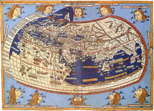
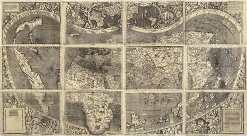
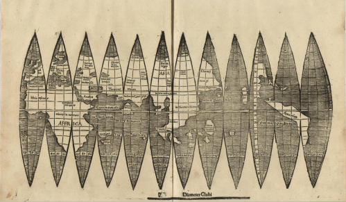
1. Waldseemüller’s single sheet map condensed the cosmographic principles the he had followed in series of elegant wall-maps that foregrounded the artifice and difficulty of the composition of the world map. Waldseemüller and his circle had actively promoted standards of global legibility, using Ptolemaic precepts in a triumphal manner to celebrate the power of naming, charting, and mapping new lands for European audiences that invited ways of telling, describing and narrating Europeans’ spatial relation to a new world. The large wall-maps that he produced in over a thousand copies promoted modes of reading globalist relations facilitated by copious textual cartouches and inventive decoration, that underscore its cosmographical nature as a product of writing, drawing, and design to affirm the growth of oceanic expanse that defined the continents. The wall map was hardly free of what Edward Tufte might call “chart junk” on its exuberant margins, but conveyed tthe excitement of heralding a new graphic synthesis of a global map over which Vespucci presided in one lunette, adding continents of a new hemisphere to the known globe, offered a cartographic solution to a problem of ordering terrestrial space.
 Martin Waldseemüller, Universalis Cosmographia secundum Ptolomei Traditionem . . . . / Library of Congress
The image is no less than celebration of the new status of cosmographical arts that elevate the medium of engraved images to tools of global description. If the twelve-sheet c wall maps Waldseemüller’s school composed, designed, and whose engraving they closely supervised set a new standard for the elevation of cartographical skill from a technical craft to a new model of knowing and seeing–and a way of making epistemological claims, as much as using transmitted forms, in ways that linked the art of mapping as a scribal technology to cultures of telling, describing, and demonstration, the wall maps invite viewer’s eyes to comprehend space outside a situated position.
 Martin Waldseemüller, Universalis Cosmographia secundum Ptolomei Traditionem . . . . / Library of Congress
In a counterpart to the large wall maps that he designed and sold, Waldseemüller expounded the modern precepts to orient one in space and synthesize global knowledge by parallels and meridians in his Introduction to Cosmography (1507). The slim volume, the basis for his identification with the unsigned gores, seven as a manifesto for the twelve-sheet engraved global wall map, over which preside busts of Ptolemy, the ancient geographer who formulated the mathematical precepts of terrestrial projection on a graticule, with America Vespucci, combined the modern experience of navigation with the ancient precepts of learning and naming place. Waldseemüller himself never travelled far beyond his native Strasbourg, but invested the map with authority to communicate geographical knowledge as a token of modernity of embodying a global geographical knowledge, albeit a modernity now displaced by the grid. Waldsemüller’s projection has the energetic displacement of the authority of a nautical chart, echoing how Vespucci declared his competency in his letter to arrive at the New World even “without the knowledge of sea charts” prized by navigators, being “more expert in navigation than all the pilots of the world.” The gores staked a similar model of expertise of reckoning and calculating distance and place by a new matrix of latitude and longitude that they embody: the preeminence of the graticule as an epistemological tools of global geography that expanded the scope and nature of geographical knowledge lasted some four hundred and eighty years until it being displaced by grids. Indeed, the value that the map was readily assigned suggests its survival in a distinctly post-scribal culture of mapping.
Did the value that the auctioneers assigned the map gores reflect these grandiose knowledge claims? The gores elegantly translated knowledge of the earth’s newly discovered hemisphere to indices the viewer could readily process and digest, foregrounding the new name that it proposed for the continent named after the Italian navigator. But they assumed a new status in the age of digitized maps, and Google Earth images of global interconnectivity, which may have been paradoxically elevated by the newly antiquated image they acquired. Rather than being sold as emblems of knowledge, the new image of the gores that Christie’s claimed to bring to public auction had gained an immeasurable status after the earlier auctioning of similar gores for above a million dollars, not to mention the unprecedented price that the United States Library of Congress agreed to pay in 2003 of $10 million for the sole surviving edition of the large wall map Waldseemüller had engraved, the one copy of the thousand-odd he had printed, of which it was something of the poorer cousin, but which had been widely touted as the “birth certificate” of America, and the map on which Waldseemüller had proposed using the name of the Florentine navigator Vespucci who had described the long coastlines of the New World in his printed letters.
The set of map gores, a complementary spherical map that Waldseemüller had described making, provided an early image of global totality that gave a similar dominance to the line–indeed, the geometrically determined line–to orient viewers to a global surface. When the late historians of cartography David Woodward and J.B. Harley tersely defined the map in “purposely broad” terms, at the outset of the monumental History of Cartography, an extremely elegant series since expanded over multiple volumes, as “graphic representations that facilitate spatial understanding of the world of things, concepts, conditions, processes, or events in the human world,” they may have been thinking of the graphic lines of the gores as such a facilitation of spatial understanding. For the gores process the encounter with the New world, the travels of the navigator, and the recovery of Ptolemaic precepts of world-mapping, and the naming of the newly discovered continents in the western hemisphere on a clearly graphic construction. Woodward and Harley’s emphasis on “graphic representations” recuperated the ancient Claudius Ptolemy’s use the Greek verb γράφειν (graphein), or “to write,” and Waldseemüller’s assimilation of that verb of the act of writing to engraving tools; it caused much revision, even by Woodward himself, of its lack of allowance for cross-cultural comparisons, but suggests a significance of writing systems as a mode of ordering space. Waldseemüller appropriated the authority of the verb in print, giving the engraved line a deictic sense of displaying space–
Waldseemüller School, 1507 Globe Gores/Badische Landesbibliothek
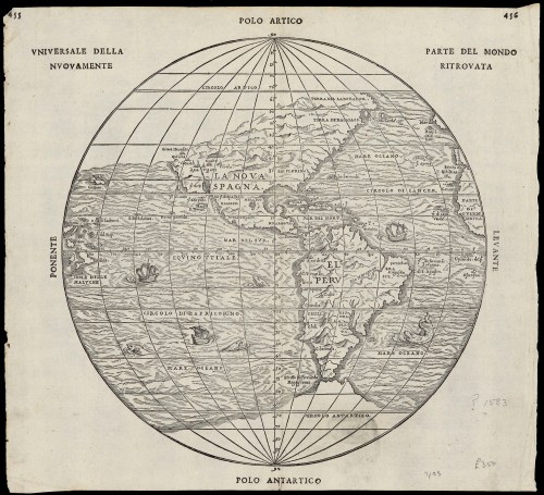
–in a map of globular design of the sort that Woodward idealized as the culmination and embodiment of cartographical principles, in a globular map of the sort that was more readily defined in a more familiar globular form by 1583, here shown in two images of the same year in “universal rendering of the newly discovered parts of the world,” printed in Italian, or discovered parts of the world, which emphasize nautical travel as the basis for the incorporation of place on the globe, and reveal the increased scope of geographical exploration in the intervening eighty years.
More broadly, however, “graphein” might be understood as the trace of the human that orients themselves to the world, hand-drawn or manually rendered. These were soon shown to be absent from the gores: indeed, the blurring of the very lines of the gores that went to auction suggest that they belong to a new visual culture of scanned images and photographic reproduction. The very traces of graphical operations were permuted and erased in new ways, as is the sense of a human presence, in ways that suggest the distance of our own visual culture from Waldseemüller’s world, in ways that the forger never intended.
In their groundbreaking History of Cartography, David Woodward and Brian Harley had celebrated the line as the means of graphical orientation, in what now seems an elegy to the art of printing. An unforgettable image remains clear in my head of David Woodward in his basement, in Madison, WI, running maps off a letterpress printer, and hanging them to dry on strings by clothespins, and his love of the ink applied to the engraved plate to present a precise rendering of space. But the fake set of gores that reached auction were not printed or drawn, let alone in the Renaissance or during Waldseemüller’s life, but probably printed some five hundred years later, from a scan of the map in the James Ford Bell Library’s website.
The gores that arrived at auction this December suggest far less of a clear trace of a human hand, and perhaps belong to a different visual culture of online images. Indeed, the astronomical value that the single sheet was invested may be a symptom of our entrance into a different visual culture of mapping–indeed, the sheet that seemed to be valued at more than a sheet of gold of the same size suggests the fetishization of the paper map in an era of web-based mapping, and mobile GPS. The fake gores suggestedthe translation of Ptolemaic terms to a visual culture that privileges the dot and the grid as a basis for orientation, rather than the engraved line, but where the aura of the writing of space persists, and the paper map fetishized in a world that increasingly relies exclusively on mediated digitized images. The set o fraudulent gores is itself something of a post-modern artifact,–less concerned with the authorities of narratives of discovery, but able to admit the false authority of the map as objective, and almost ready to accept the value of its aura even if it was only an image grab printed on old paper.
2. The astronomical price set for the map rose above $1.2 million by a prestigious auction house for a single sheet of paper might remain hard to grasp for many, but reflected the priority of naming the New World, as much as their claims of knowledge. Long identified as a “birth certificate” of the New World–quite anachronistically misapplying a term only identified within the nation in the early twentieth century as a public registration of identity in 1902, which later gained currency as a public document –the prestige of the map echoed less the larger projection of navigational discoveries that Waldseemüller signed, than how the other maps tied firmly to the cartographer were popularized as a “birth certificate” of the Americas.
But the relatively recent recovery of a new–and previously unknown–copy of the unique set of global gores, discovered only last June in the library of the Ludwigs Maximilian University of Munich, earlier known only in a print discovered in 1901 in Germany, this time apparently printed on a different woodblock, with far less thick bounding lines, which also proclaimed the name of “America,” if it seems of slightly later date–as if in a revision of the first set for a larger audience of map-readers. Did the new discovery reveal an unknown experiment of the St. Die school of Waldsemüller to continue to experiment in more valued cartographical forms? The suggestion of continued refinement of the globe to reach new reading audiences described by Chet van Duzer suggests the broad charge of the circle of cosmographers that center around Waldseemüller in St. Die, and their continued refinement of the charge to craft a synoptic image including the New World.
Ludwigs-Maximilien-Universität, Munich
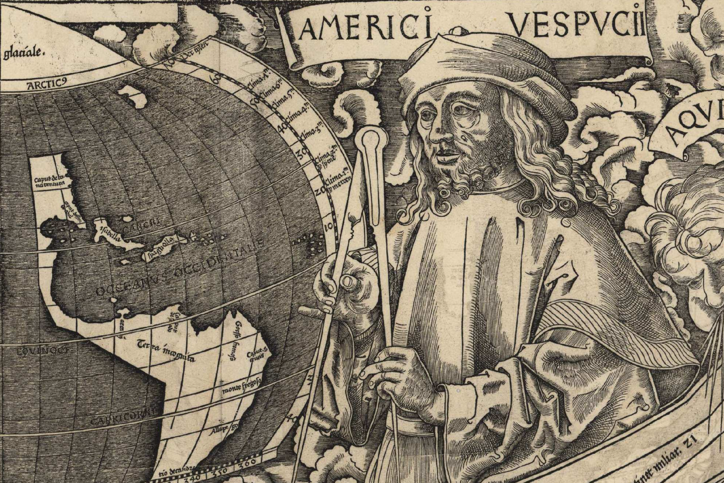
The logic of the map’s identification had gained broad currency in 2003, when the Library of Congress sought to justify purchasing for $10 million the sole surviving 1507 wall-map to show America, shown under busts of Claudius Ptolemy and the navigator Amerigo Vespucci. When the Library of Congress had arranged to purchase the massive twelve-sheet engraved wall-map from Prince Waldburg-Wolfegg of Baden-Württenberg through the House Appropriations Committee, the high price tag was justified as joining a premier collection of maps, and claiming the “birth certificate” as the property of the state, investing a legal value derived from Waldseemüller’s 1507 reasoning that the continents “discovered by Christopher Columbus, captain of the King of Castile, and by America Vespucci, man of great an excellent ingenuity,” no objections might be raised to name it after the navigator Vespucci, whose popular letters on the New World he believed justified their naming.
What better to confirm the act of naming than on a map? The legibility of the Waldseemüller projection gained almost mythic status as the cosmographer described his own aims to describe the world map “both as a globe and as a projection” in a treatise on cosmography he printed in 1507, which assigned the name to the new continent. The authority of this historical claim imparted considerable value to locating the map with the cosmographer who had noted his writings the existence of a “newly discovered region” that he could “see no reason why anyone could justly object to naming” after the navigator who he identified as its “discoverer.” The wall-map seemed to concretize the poetics of discovery of the Renaissance, for the first time rendering “America” legible as such on a map, in ways that the smaller gores–which also foreground the new continent’s name–form something of a poorer cousin, and was already located in the James Ford Bell Library at the collections of the University of Minnesota. The previously unknown copy of global gores, though unsigned, served to proclaim the name of the new continent to its viewers, even if it was the third copy of the gores destined for a small globe of 11 cm diameter, seemed as if they would be destined to start a bidding war. The auction house, which had fairly recently sold a similar copy of the same map gores, long thought to exist in but one copy, but though to be printed in a thousand copies, was pleased to identify another set of gores with its prestigious name.
The gores had been legendary as a new projection popularizing a new model of geographic knowledge, adopting a mathematical formulations figuring global geography devised by Peter Apian. The image is as an emblem of the mappability of terrestrial coverage, and the triumph of cartographical skills to locate the sickle-shaped continent, if only partly and schematically shown. It served as something of a manifesto for the use of geometric techniques of map projection to orient viewers to the discovery of the New World by naming it “America,” and suggesting the geometrical tools to ensure its legibility to readers both on a graticule and as a term–literally placing it in view, as if for ready consultation, transforming the new continent–“a land beyond the stars,” for Vespucci–so as to allow the viewer to perform the itinerary Vespucci had described as “long, straight shorelines and . . . filled with countless inhabitants” as “not an island, but a continent,” in his 1504 Mundus novus, and had claimed to provide his patron, Lorenzo di Pierfrancesco de’ Medici, with records, in the form of a chart and a globe of spherical form, in 1500. iWaldseemüller emulated the same claims in promising two maps in an Introductio (1507) on a globe and a flat surface, in ways that have led both the maps to be associated with the Renaissance cosmographer’s treatise, and the new gores to be presented as an unknown and recently discovered version of an extremely rare map. But the new value of the map undoubtedly also grew in our own age of globalism as an early image of the globalized world.

 Map as Announced for Auction above reproduction in University of Minnesota Libraries
The power of this early image of globalism was sure to create an intense bidding war, as a tenuous contact to the cosmographic knowledge that Vespucci claimed to allow him to judge where he lay on the oceans in his travels to the New World, based on cosmographic knowledge not apparent on sea charts alone. The claims for cosmographic expertise as a basis to map America was distilled by Waldseemüller, who praised the cosmographical abilities that led Vespucci to ascertain the size and location of the New World, and led auction house estimate Christie’s released to appear justified. Yet the set of global gores which appeared to be the first mapping of the new world were faked,–and were soon showed to be derivative of a printed map located since 1954 in an American university library, and which, who displayed it in high res images available online since 2005, gained considerable renown outside of the walls of the library itself.
3. If the appearance of these maps of quite unclear provenance had raised eyebrows immediately for connoisseur was revealed before the auction hammer sounded: comparisons to the high res interactive gores displayed at the James Ford Bell Collection‘s website suggested that the newly surfaced “map” derived from the digitized image, rather than being a sixteenth-cnetury imprint that it had been identified by the auction house to be. Rather quick comparisons of online images had strongly suggested that opportunistic forgers had exploited open access to scam a growing antiquarian market by manufacturing a slightly differently sized “edition” of the gores, by using image capture to sell a download scan of the original map: traces of a digitized version of this specific engraved image betrayed the theft of what was a treasured property that the James Ford Bell Collection of the University of Minnesota Libraries had long displayed online as a high resolution TIFF.
The manufactured appeal that of the image as an engraving situating the discovery of the New World on a globe might have set a record for rare maps had it reached auction. And was, as it turns out, not the only such “new edition” of the same gores that had been sold at a price greater than a million dollars, raising some fears of a history of falsifying Renaissance maps from digitized photo reproductions. The triumphal early modern statement of the principles for mapping the New World assumed specific value as a rare map. While the auction price was not addressed to map dealers, those practiced to read such early engravings had suspicions from the very announcement of its sale,–suspicions based and not since Christie’s had previously offered similar, if differently cut, editions of the same set of gores that reconciled late fifteenth-century nautical discoveries with a picture of terrestrial unity. Map-dealer Alex Clausen of David Ruderman Maps determined after comparing online images that “the [allegedly] printed image was either quite heavy or missing all together” from the sheet of paper–even if it was being sold for approximately the price of a sheet of gold leaf of comparable size, and claimed its value as a unique surviving map of the school of Martin Waldseemüller which had first mapped the nautical discoveries in the New World on a map of Ptolemaic precepts of terrestrial projection.
The modern fear of the detachment of the map from the piece of paper was, in fact, a correct apprehension of the state of play, in a world where are surrounded by constant proximity to online images with which we increasingly interact. Did the website help the forgers transform the material surface of the map to an amazingly detailed high-quality image downloadable at several sizes and resolutions, passed off as an “authentic” discovery of an unknown edition of the map? Although the map has been described in terms of an opposition between a “fake” and “authentic” historical record, and the historical value of the map gores is considerable, the surfacing of the map suggest the coexistence of two quite specific visual cultures–the mathematical determination of terrestrial position and totality to create a disembodied view and the proliferation of mediated images online, two cultures and ways of seeing that in this case rather catastrophically if somewhat comically overlapped, reminding of how much we rely on a digital support structure for looking at maps–even early modern engraved maps from the sixteenth century that themselves processed the first Age of Discoveries.
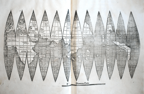
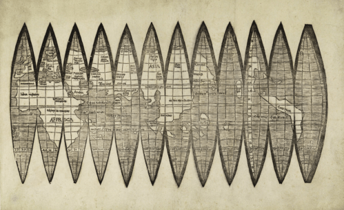
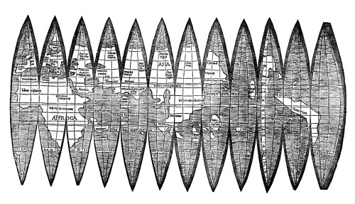
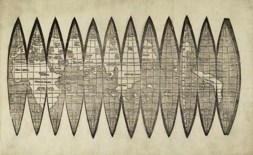
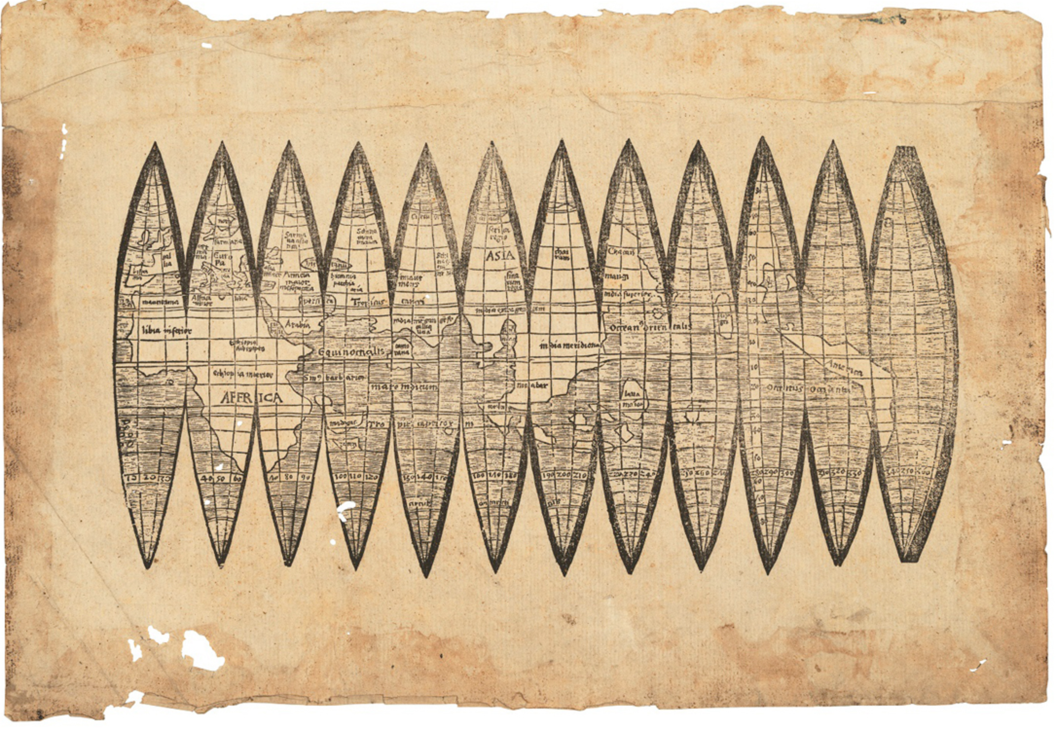
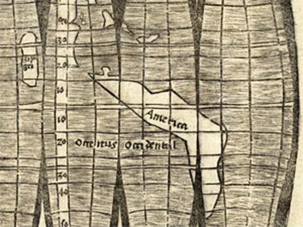
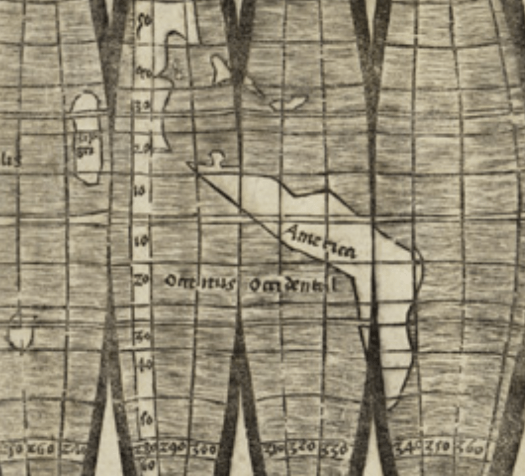
The sixteenth-century sectional global gores had bracketed an expansive terrestrial expanse by thick, black lines in a declaration of the totality of global coverage on twelve interrupted ellipsoids segments the world into thirty degree sections; the map used a new form of projection to depict the earth’s expanded surface along geometric principles of transferring an abstract sense of space, with no cities at all. The projection offered what may be the first prominent placement of America in the ecumene, or inhabited world, in an expansive western ocean, or Pacific, which all but invite viewers to rotate the surface of a small globe, fashioned of just 11 cm in diameter, in an emblem of the power and promise of cartographical tools–and a cosmographical purification of the fascination and wonder of the recent nautical discoveries that perpetuated the early modern fantasy of scanning a disembodied view of the terrestrial planisphere.
 James Ford Bell Collections/University of Minnesota Libraries
For the mathematically trained school of cosmography at St. Dié, where the cosmographer Martin Waldseemüller advanced mathematical precepts of projecting terrestrial continuity, the map offered a new architecture of global space–and an icon of modernity, offering an early modern exercise of the disembodied view, for those entranced by the geometric elegance of transferring the earth’s surface to curved lines of latitude and longitude. For the forger, the map was rather a grabbed screen image; if he executed the copy while overlooking the traces of the digitized version of an engraving, his version was so poorly forged from a scan that the discovery of the forgery did not in fact take long. Did the map gain a new value as a memory of a time when the world could be transposed to a single sheet of paper, as much as for naming the new continent?
The price set by the auction house was less easy to grasp –the proclamation of cartographical modernity surely distinguished the intellectual prowess preserved of early modern cartographic tools Presented as something of an art object, the price was inflated independent from the art of cartography, or the accuracy of the map, but its historical value: the apparent woodcut was valued for its rarity, and its declarative construction, in a way increasingly historically removed, of orienting oneself to a bounded world on a single sheet of paper. If the original set of gores was gouged in wooden plates, the now clear origin of the global gores on auction in a digitized image raises questions not only about forgery, but about continuity–and indeed about the value of maps–in a visual culture increasingly oriented around online imagery rather than paper maps, and the relation to the mapped past.
Is the arrival of this map at auction, and the quick questions that it provoked in on online information ecosystem, a sign of our own distance from engraved and printed maps? The antiquated image of a crisply divided world of terrestrial continuity perhaps gained innate appeal in an age of remapping for its material solidity and certainty. Divided by intervals every thirty degrees, it helped orient viewers to the first reports of the New World Amerigo Vespucci described in 1504. The map’s unique form of projection, designed by mathematician Peter Appian and the astronomer Johannes Schöner, was perhaps not for assembling an actual globe, but as proposing the legibility of a terrestrial surface ruled by parallels and meridians, and to allow readers to place the New World on its surface: apparently planned by humanist Martin Waldseemüller, it presented a new proposal for remapping the world on a Ptolemaic system. But it was priced as if it were a piece of intellectual property, performing the cartographic trick of naming that Waldseemüller had himself assigned the region, adopting a new poetics of discovery, reasoning that “as both Europe and Asia received their names from women, I see no reason why anyone should justly object to my calling this region Amerige, or the land of Amerigo, or America, after its discoverer” [my italics]. The apparent assigning of the name in the map–even if Waldseemüller made his claim in a treatise on cosmography–has given each of the maps their value.
To be sure, Waldseemüller seems to have asserted his intellectual property of the map in his Introduction to Cosmography (1507), an early primer of global mapping. The gores foreground prominently the cartographer’s innovative inscription of “America” lying in the western hemisphere, below the Indies where Columbus landed and beside Japan, bestowing Amerigo Vespucci’s name on the New World for the first time. But the value placed in the new proposal of terrestrial space, orienting viewers to a crescent-like blank “America” in a version of the Ptolemaic projection, as if inviting one to read the new place-name in the western ocean. The cartographer proudly inscribed the blank region with the name of the navigator who first described its coasts in detail.
If long valued for first locating “America” on the map, the astronomical valuation of the new sheet raised eyebrows. If the projection might have assembled a small globe that would be an object of constant curiosity and discussion–showing the Pacific ocean for the first time, based on recent navigational discoveries, in ways that might create a globe of just 11 cm in diameter to sit on a bookshelf, desk or in a library, with easily consulted indexicality, its value today seemed to exist as a curiosity and collectible of the symbolic claims its engraved surface staked–even if the gores were themselves unsigned, and the format of projection was not necessarily the first–the humanist Waldseemüller’s map may even derive from other small globes, of the same size, even if he invested the curious mathematical projection with clear pedagogical intent, and is assigned the paternity of the map projection by posterity–and indeed the paternity of the project of the global geographic map.

Minnesota Public Radio/Minnesota University Libraries
4. If the traditional interactive nature of this sort of assembled map may be the reason for the extreme rarity of the survival of the gores, the Appian projection seems to have been printed as a model of the mathematical tools for assembling the proposal it advanced of terrestrial continuity–and its value as a teaching model. The appearance of wat seemed another printing of the 1507 edition stored in the University of Minnesota, was thought to be a new imprint of a classic map; though assumed until recently the sole surviving copy of a small version of the first maps of the New World the theological and cosmographer Martin Waldseemüller designed in 1507, which pictured Vespucci beside Ptolemy embracing globes of the western and eastern hemispheres, the gores of the globe seemed a new set of techniques for describing terrestrial continuity, and estimates of its value–up to #1.2 million–just above the approximately 2 million DM (over $1 million) the Bavarian State Library paid for a printing of what seemed the woodcut of apparently identical global gores, discovered in an edition of Aristotle in the University of Munich in 2012, and the bid of over $1 million Christie’s had happy sold another, more trimmed image of the map in 1991: the new version, apparently printed on a large piece of paper, with minor damage to its uncut edges, seemed destined to attract an even higher bid in 2017, although what audience of collector or internet mogul would raise the bidding war was never known.

To be sure, the greater rarity of earlier globular projections of the world that predated the discover of America–or the new coastline of the western hemisphere–as that included in the so-called Teutsche Ptolomaeus, a woodcut from Nuremberg of earlier date, that used the spherical projection of climates and parallels to project continents as Europe, Asia, and Africa in a spherical globe in c. 1490–just before the discovery of the New World, which created and afforded a far less cognitively appealing form of mapping without the innovative introduction of mapping a new world and less ostensive design.

 Teutsche Ptolomaeus (c. 1493)/New York Public Library Digital Collections
As the map displayed a far greater “terra incognita” to Ptolemy or the moderns, the map was less innovative in its structure or terrestrial description: the odd single sheet, in contrast, if unsigned, presented to viewers a set of gores that was adeptly employed the principles of projective geometry as a guide to orient viewers to scan a total coverage of terrestrial space on a flat surface: what had been a humanist teaching model seemed destined for high valuation as an object of surprising antiquarian value that captured the vicarious experience of the discovery of a new world, and the invention of a new format of projection–although it was undated, and was not anything as are as the above image of a German-language edition of Ptolemy–but was cast as a major work of engraved art.
The unknown edition of the first mapping and naming of the New World thought printed near Strasbourg in circa 1507 seemed a woodcut designed ordering the global watery surface on Ptolemaic for scholarly consultation. The auction house identified it as the fifth in all of this unique projection of the world’s surface, and the third to have resurfaced in the lats fifteen years, but an image that suggests the early use of maps as material forms. Three other similar global gores that elegantly map the world’s totality on visibly curved parallels and converging meridians were sold in a thousand copies, probably to be pasted on a globe. Rather than being gouged in the sixteenth century, the sheet of worm-eaten paper and yellowed edges was a photographic reproduction–not worth, effectively, the paper on which it is printed. The image not only suggests an intersection between an online world of digitized images and the world of the antiquarian, but of visual cultures. The edition that was poised to set to go to auction was quickly found to have been cleverly and not so scrupulously faked, bearing traces of modern glue under the ink, a discovery that has raised questions about whether several gores of the globes that surfaced soon after they appeared in digitized TIFF’s or JPEG files of ready reproducibility.
It may have been as authentic, in a sense–even if it was not engraved map or Renaissance woodcut but created by some sort of hustler if not a psychopathic antiquarian: far more viewers have consulted the online versions than would ever see the original. But the fraudulent nature of the object billed as yet another edition of the gores was quickly demonstrated–as the copy was shown to bear the imprint of globe gores that the University of Minnesota’s James Ford Bell library has owned since 1954, and recently made available online, as if to perpetuate the teaching model that Waldseemüller and humanists seem to have assigned the map projection. But Christie’s seemed particularly eager to promote the new “discovery” of the map of the discoveries as a “previously unknown” version of the map thought to have been printed in a thousand copies back in 1507.
Global Gores Announced for Sale by Christie’s Auction House/Kirsty Wrigglesworth (AP)

Globe Gores from James Ford Bell Library as displayed online
The value the auction house hoped to obtain was even more striking because, in an age of scarce humanities funding, it was not even a teaching example, but a large-scale object used to assemble a quite small globe, tied more to an aura of exploration than geographical accuracy or clear cartographical advances. Mathematically constructed from the precepts of projection, whose curved meridians converge on the unknown poles; the gores were an ideal form to describe hemispheres and nautical expanse, revealing the size of oceanic travel, and comprehending a synthesis of geographical knowledge in transportable form in reduced form, unlike the synthesis by which Martin Waldseemüller combined Ptolemaic principles of map projection with recent nautical discoveries to depict the entire world’s surface. But the innovation of the larger multi-sheet production was present in the unsigned gores in the identification of the new land-mass “America,” after navigator Amerigo Vespucci who described its shape, a trademark which quickly passed into common cartographical currency. But the identifying inscription of the land as “America”–investing the map with a sort of intellectual property was so valued because of its quite anachronistic claims as a “birth certificate” for the hemisphere. Valued for naming the unknown lands and placing them on a mental map–as much as merely showing the earth’s surface to be round–the globe gores staked a claim to their modernity, which, if it suddenly seem. Yet could it indeed be worth more than a thin sheet of gold of the same size?
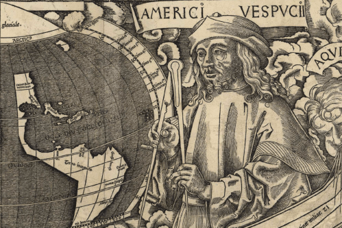
The set gores provided early testimony of broad interest to place the New World on fixed meridians and parallels had, after all, created a sort of mythic foundational reference point for geographic science as far back as Alexander von Humboldt. The first knowledge of its possible existence was provided by historical hints of its presence in map dedications from the Renaissance, and the search for maps that celebrated the discovery of the New World, and the place of “America” in it–even if America seems defined as South American continent alone. The cosmographer Waldseemüller had so celebrated Vespucci as a new modern counterpart to Ptolemy in his huge engraved wall map of western and eastern hemispheres of 1507, the smaller map that arrived at auction seemed a poorer cousin, of far more rudimentary form, but with even more striking claims of legibility. The identification of the new continent with its namesake was more elegantly stated in the frame of the larger projection, where Vespucci, standing with a set of dividers in hand, served as a signature for crafting an expansive projection reconciling nautical charts on a continuous surface of meridians and parallels.
 Library of Congress
that was echoed in the continuity of the set of global gores seen for a century as the result of Waldseemüller’s complementary crafting of a solid globe.
 Courtesy James Ford Bell Library/University of Minnesota Libraries
The unique value of the global gores as a separate map of the new content may seem an oddity in an age of global map coverage, imbued with a narrative of discovery. Early curiosity about discovering the discovery of a fifth copy of the gores projected to be bid on for $1.2 million was replaced by consternation, as it was found to be a fake. The origins in an online image revealed not only scamming an auction house that dared to ask such an exorbitant price for a piece of paper cast a light not only on the long-shadowy rare book trade, but of what the authentic status was of an early map. As questions proliferated about the authenticity of the item to be pulled from auction, Christie’s reps flew to Minnesota to consult the global gores of most secure provenance, stored in the collections of the James Ford Bell Collections, which has long featured high quality scans of the gores online. Careful comparison to the object slated to be sold had spied as the source for the surfaced gores, whose uncertain provenance muddied their story: the faking of the map raised questions about its status and value, and the readiness to accord such an unwarranted value to the map as if it were a . Closer comparisons confirmed the gores was a skillful fake bearing traces of photo-reproduction of the sectional map: although printed on paper from the early modern world, it derived from images of the very same map in the James Ford Bell, that the auction house had failed to note; the gores on auction contained inexplicable uneven inking and was even printed or transferred atop a bit of glue in one section.
The admission global attention in an information ecosystem increasingly more habituated to fraud, addicted to unmasking, and habituated to tracking exchanges of sums so astronomical for most that they almost have little meaning in an age of increased economic disparity. Discovery of the fraud generated far more attention as the faking of a map recently prized as a foundational cultural document–the large twelve-sheet map of America, signed by Martin Waldseemüller and showing the discoveries of Amerigo Vespucci made in the first years of the sixteenth century on twelve large sheets in a huge map of four and half by eight feet as, after all, a valued piece of cultural legacy acquired by the U.S. Government to be permanently displayed in Washington’s capital, whose acquisition over a course of decades from a German Prince which was kept in the family castle demanded approval by the German government. If the United States’ government’s purchase of the large wall map had demanded intensive legal negotiation given its value as a cultural property as the sole map of such detail to name America and the western hemisphere, the reduced gores, if a poorer cousin, which had raised some attention once its discovery was announced among experts, whose suspicions were aroused by a shady provenance among a set of papers inherited from a paper collector, grabbed global attention as it was announced to be a fraud. The story of the map’ faking was less compelling than the near arrival of an icon of cultural property of such extreme rarity at the auction block.
The discovery of the gores poses questions of the relation between fake and original in an age of digital scans–when many more will consult the scanned image than its “original”–may deserves attention as much as the surprising ability of the image to move through appraisal and estimate, and be slated for bids December 13. The questions that its identification as a fake immediately raised to the original gores, themselves displayed online in high res scans, showcased the modernity of the map as first naming “America”–and of the cultural value of the map that perpetuated the fiction it literally placed “America” on the map. The unmasking of the single sheet of printed gores as a fake may call both for an examination of how a single sheet of paper gains authority as evidence of and a vicarious testimony to the Age of Discovery and its relation to the authenticity of the versions that had recently surfaced in the past twenty years, and of at least one set Christie’s had relatively recently sold at public auction at a comparably elevated price.
Gores Announced for Sale by Christie’s Auction House/Kirsty Wrigglesworth (AP)
Its presence in the Christies lot tells us a lot about our attachment to maps, and the place of the paper map in our imagined relation to the past. The outing of the ‘faked’ version of what was thought the earliest map of America, shown as a boomerang shaped island, larger than Europe, below the Caribbean, may well provoke reassessment of the recent surfacing of similar sets of gores that place America on the map–a resurfacing of other editions of the “strip map” on thirty-degree intervals–over the previous fifteen years, with the surfacing of several uknown global gores mapping America that have come to auction. The gores transcend antiquarian value by inviting observers to arrive in the New World–as if illustrating the biblical injunction to “seek, and ye shall find” in Mattew 7:7, beckoning early modern viewers to its blank space–and continuing to orient viewers to the promise of America, if only vicariously to imagine the experience of discovery.
Waldseemüller Gores/University of Minnesota Libraries, James Ford Bell Collections
Even though the map has been dismissed as a fraudulent copy, and not a five-hundred year old engraved image at all, the media blip surrounding its creation may both force us to assess the value of the copy–in many ways, the currency of globalization–if not the increased value we place on the digitized image, and the antiquated media of a paper map. The presentation of the fraud at auction compels revisiting the appeal of the claims of modernity made by the map, and modernity of its apparatus of cartographic forgery, or the tools of forgery in an age of digital photo-reproduction, when we are increasingly surrounded by digitized imagery and removed from the printed artifact–where satellite maps are indeed icons of globalization.
In an increasingly interconnected era far more likely to tap maps than consult paper, the over-mapped nature of the world makes its blank spaces not only alluring for nautical voyages, or excited contemplation, but exercised far more than antiquarian value by activating an antiquated era, if not providing an early instance of branding a new continent. Waldsemüller, as he first reasoned that the continent be named America, for Amerigo Vespucci, is widely credited with creating America’s “birth certificate,” in a nineteenth-century fantasy that the continent demanded identifying papers. Although the map is the poorer cousin of the far larger multi-sheet signed Waldseemüller map displaying the growth of universal geographic knowledge, printed for learned readers as an icon of discovery, though to be printed in a thousand copies. The smaller scale globe printed on twelve gores was a cheaper, ready-made version, inscribing “America” on the surface of a spacious new continent for a far larger audience. As if an interactive map of a more ready made tactile sort, the global gores invited users to assemble a new image of an expanded world. If the gores of new information offered a new syntax of geographic knowledge, collating information in an accessible compact repository that confirmed the earth’s size and terrestrial continuity, its publication has long been recognized as a sort of reading companion to Vespucci’s Mundus novus [New World], an account of the discoveries printed from 1504; the global gores seemed to allow a man of letters to gloss in his study, more than an actual tool of spatial orientation.
 Ludwig-Maximilians-Universität München (from facsimile)
The map’s topnomy, if declarative and elegant, was notoriously abbreviated. But it has long recalled in compact form an era when we were enticed by open spaces and vague regional names–as “India Superior” or “India meridionale” and “Troy,”–points of reference for a scholar more than an actual navigator–or “America,” the name that invested the “strip map” with such intangible value as a map. The terrestrial image that contained wide open spaces, if with relatively few toponyms, compared to the expanse multi-sheet wall map that situated new world cities in a curved graticule of parallel and meridians of Ptolemaic form–and had showcased the points of cultural contact in two hemispheres. The far smaller gores left the New World blank, but suggested a short-hand to calculate its distance, as if it were already an object of status and contemplation.

Could it be that today, in an era where we have moved beyond the printed map and the graticule of longitude and latitude to detailed coverage of the world, and the distance of a time when we are enticed by its open spaces, could it be that the growing trade in old maps transformed the map gores to an epecially attractive investment for a member of the global elite with considerable disposable income?
The format served to reduce the world to a small globe of diameter less than five inches, embodying space to illustrate a grasp of the world’s newly expanded size: the assembly of the curved earth’s surface prominently inscribed the site and location of the earliest image of America, a slender arc of land lying at the joining of the “eastern ocean” and “western ocean,” in a striking emblem of terrestrial continuity the was a low-level luxury object itself. But the scan existed in a world of the inflated prices of objects of extreme rarity, the private possession of museal artifacts and monuments of culture, and the remove of the map, in a sense, from a site of memory–and indeed from a fixed object that exists on paper.

While we are urged to see technologies as peeling back knowledge, and advancing new mapping forms of mapping, there seems no better statement of this myth of modernity that casts global mapping as a unidirectional flow than the first sectional map “gores” that peel the surface of the earth open on a plane; the instructional aims of transposing the earth to sectional map “gores” served as a rare icon of the stability of geographical knowledge, whose globular form advanced an image of a total mapping of the world long before the continuous global coverage afforded by GPS. But the value of the maps that put America “on the map” have so dramatically escalated in recent decades–since 1992–to acquire a value that can only be viewed on their own. The expectation of such astronomical bids for the sheet which seems a high-quality digital scan of the above set of gores, bearing ghostly white traces of a repair to a torn section of the above gores, confirmed that rather than being the product of a gouged woodblock over five hundred and ten years ago, was a wonder of photographic reproduction or a scan. And although the value of the engraved image had escalated in the previous decades as the “birth certificate” of the New World, did the unsigned set of gores offer the material record of the first inscription of the discoveries, as has been so long believed? Or is it more of a nineteenth-century fantasy–or nineteenth-century version of a Renaissance fantasy of naming–to imagine that an official certification definitively bestowed identity on a place or person in relation to a state? The metaphor of a “birth certificate” seemed in itself as ahistorical as one could get, but it was the earliest time that Vespucci’s name was effectively argued to be applied to the New World.
The printed image of the map that was appraised and almost made it to auction expose the intense desire for what were deemed the earliest maps registering the New World, first nurtured by antiquarians, but now given broad cultural validity, as well as the ease of how printing of digital scans invited forgeries in an inflated market for old maps. The cosmographer-theologian Martin Waldseemüller (c. 1470-c. 1522) had described having constructed several maps–maps both “in solid [version] and in a plane [tam in solido quam in plano],” interpreted as describing two cartographical constructions, the suggestion of a spherical map has become something of the holy grail of the history of cartography. Walseemüller lived in the first era of printed editions of Ptolemy’s Geography, an ancient treatise whose precepts for creating cartographical projections of the earth’s surface were taken as a charge for the German geography. Few gores were thought to have survived, given their ephemeral unbound nature, although the discovery of gores of the globe around 1890, or the fourth centennial of anniversary of America, sought–if not known or seen–by geographers from Alexander von Humboldt, as the first public cartographic communication about the New World after popular editions of the explorer Amerigo Vespucci’s letters described his voyage had become a fundamental text to orient readers to the New World that had been recently named.
The magnification of the value of the map, and the sales of editions of the gores, have reached something of a frenzied pace in relatively recent years, as a surprising number of early maps of America have reached auction and been sold. After the announcement of the 2003 purchase by the Library of Congress of the sole known copy of 1507 world map, where the expansive twelve-sheet map would take its place as “the crown jewel of the Library’s already unparalleled collection of maps and atlases,” Librarian of Congress James Billington proudly asserted, after the United States House of Representatives’ Appropriations Committee justification approved purchase of the large wall map, printed from twelve woodcuts of great detail for the astounding $10 million asked by its owners–and displaying the new continent in one of its sheets. The sale of the map shattered records and raised the bar on global sales of the first cartographical images of the New World, and set new standards for the sale of printed cultural artifacts–

–and raised the status of the printed map’s status as a privileged point of access to a distant past. Another similar set of global gores was sold for the unheard of price of $1 million in 1992 to the Bavarian State Library at Christie’s, flooring which another set of gores discovered and sold in 1993, raising the number of known gores to four; the fifth set of gores seemed poised to exceed Christie’s expectations at a record-setting price above $1.2 million, a good percentage of which would of course remain in house.
The “globular” projection accentuated the situation of America in a watery globe staked a proposition of global continuity, measuring terrestrial expanse on clear indices, in ways that were increasingly taken as a tactile relation to a global past. But the propositional nature of the map as an elegant emblem of terrestrial continuity seems diminished in what was passed off as perhaps an unknown edition of the Renaissance gores; while valued as an icon that situated “America” in an image of global unity, the iconic map was showed a photoreproduction deriving from a digitized image: the elegant icon that introduced the ability to contemplate the earth’s largely watery surface, not only matching the digitized version of the rare woodcut gores displayed online by the James Ford Bell Collection online at high resolution since 2005 to allow interactive exploration, together with a cornucopia of historical maps. If the sheet of gores was thought to survive in one copy until 1992, it remains the only copy of secure provenance, though its identification with the humanist-theologian Waldseemüller was recently questioned, despite its ahistorical claims to also be a “birth certificate” of America.
University of Minnesota Libraries/James Ford Bell Collection
The UMI website provides lovers of old map with a platform for observing high quality scans. Waldseemüller seems to have described publishing a set of terrestrial maps in 1507, identified with the gores, together with a far more costly twelve-sheet engraved wall map, of thirty-six square feet; the sale of that map in 2003 for a record $10 million to the Library of Congress, helped place an unprecedented value on early world maps, if the sale of an earlier version of the gores discovered in 1992 had already driven their price to $1 million. The humanist cartographer had described his creating of two maps– “totius orbis typus tam in solido quam in plano . . . pro communi studiosorum utilitate paraverimus [we have prepared a map of the universe for the collective benefit of learned men both in solid form and in a plane]”–has inspired conjectures of what sort of globe the cosmographer might have prepared to show the New World, and encouraged belief in the existence of such an unfound material artifact.
Although the gores are not signed by the cartographer, the late nineteenth century attribution rests on the attribution of Lucien Gallois, relying on a longstanding conviction that the large planisphere of the world, created in a Ptolemaic model, was not the sole creation of the St. Dié school or of he enterprising cosmographer theologian. The elegance of Waldseemüller’s assiduous synthesis in the expansive wall-map, which displayed Spanish discoveries in the New World, reconciled Ptolemaic precepts with nautical cartography. The attribution of the gores reflected a belief that the expression in the dedicatory letter of the planisphere describing the creation of maps “tam in solid quam in plano” long interpreted if two distinct maps of differing cartographic media; in such an interpretation, the gores were seen as a sort of counterpart to the work of the same cartographer, prominently placing “America” before the viewer’s eye. Links between these maps was recently debated–as has the design of the humanist circle of a globe, given their conservative commitment to cartographic representation, rather than devising new cartographic media: the St. Dié school sought to preserve exact reference to coordinates in a Ptolemaic system, which was all but abandoned in the set of map gores–although the gores were identified with the German mapmaker since they were discovered ca. 1890.
Although the gores were unsigned, belief they constituted a lost counterpart to the Waldseemüller cartographic corpus of a more material interactive form, designed to be cut out and form a small globe by their user. The material nature of a process of interaction has been taken to explain the sheet’s low survival rate, and existence of but three examples. Yet the enormous price for the 2003 Library of Congress sale–which secured the existence of the earliest map showing American in Washington, D.C. in the United States government’s possession, no doubt elevated the price of other early maps similarly identifying the region pf the New World as “America,” as if it were a certificate confirming, in possessive terms, rights of European humanists to name the New World, much as the Prince Waldberg-Wolfegg used the unique nature of the engraving to name his price of $10 million to the Library of Congress in 2001. The vague provenance of the newly surfaced gores of heavy lines raised eyebrows, but the promise to provide a similarly unique globe gores naming the New World.
But the fraudulent nature of map now appears a casualty of the wonder online accessibility of high-res images, whose illusion of tangibility must have made the gores quite a tempting target for a skillful hack, as the over-inflated prices for early maps were boosted, mutatis mutandi, as precedents of the conceit justifying the naming of territories–and a Renaissance conceit of naming. The utmost intangibility of naming places in the New World on a uniform graticule may have confirmed the ownership of the “trademark” America by the United States government, in ways that helped escalate the interest on the discovery of what seemed a new printing. The apparent find was no doubt too tempting for Christies to pass up on announcing. Their appearance seemed credible, if in a sort of Harry Potter way, margins yellowed, worm-eaten in places, and ragged uncut edges raising questions about their stage in a printing process. The paper was authentically antique, but the ink was not closely examined–until it was noticed that some of the ink lay atop glue used in spots to restore the paper, and that no identifying watermarks–a critical test of the location of paper used in old books–appeared that were similar to Waldsemüller’s printed works which might trace it to St. Dié.
 Kirsty Wigglesworth/AP
The attention to the fraudulent creation of the sheet of twelve ellipsoid gores, ordered like the sectors of a balloon but often discussed as a peeled orange, may have occasioned something like a flight of fancy, imagining the first map as a site for the narrative of national identity. The near-acceptance of the map–and an earlier similar set of gores, surfaced fifteen years ago at the same auction house–suggest that one might also situate the creation of the gores at an intersection between the aura of the Renaissance engraving long imagined to map the discoveries and the manufacture of evidence by screen grabs or scans, and digital imagery.
5. The fraudulent map seems to bridge two information ecosystems often treated as incommensurate with one another, but which intersected in the apparently elaborate opportunistic fraud. But one couldn’t wonder if the resurfacing of new copies of the global gores in the past fifteen years revealed not the serendipity of archival discoveries or our immersion in a world defined by the flow and circulation of digitized imagery. The concealing of temporal disjunctures is, of course, a basic trick of the forger’s trade. But one might consider how the somewhat ingenious fraud of recreating the woodcut Renaissance gores displaying the earth’s continuous surface as a performance piece, as well as a scholarly deception: the plans to sell what seems a scanned version of a map made widely available in digitized form bridged two distinct regimes of mapping–if not ways of seeing–that are artifacts of our own modern age of digitized images and online views, with the modernity of the claims of a Renaissance map to describe the discovery of a new world, and indeed to bestow a name on it of a mapmaker, who converted Columbus’ discoveries to geographical form.
While these two ways of seeing certainly muddy the waters of intellectual property, their attribution to a learned cosmographer both boosted their aura of authenticity and market value, and indeed attributed an authentic level of authorship to the set of gores, despite its lack of any actual signature. But if we are apt to downplay the value of the reproduction as a copy, it may be that in the globalized world–where they copy is king. The success of the printed copy of gores has unintentionally offered something of a sort of media archeology, linking media that advanced quite different versions of modernity: the twelve sectional gores on offer were a skilled reproduction of the famous projection of the earth’s surface on a globe, after all, a rarity stand-alone map designed by the circle of Renaissance humanist theologian Waldseemüller based in St. Dié by reconciling Vespucci’s voyages with Ptolemaic precepts. The attention the reproduction won among auction evaluators may set a benchmark in skillful frauds of early printed world maps for what was something of the Holy Grail of the history of cartography; known in but four copies, first dated in 1890–just before the fourth centenary of America’s discovery, as if in a feat of early marketing, in Lucien Gallois’ Les Géographes Allemands de la Renaissance–as a long-lost globe described in 1507 as mapping the New World in small form. (Doubts raised by a recent historian of cartography suggested that researchers had overeagerly attributed the unsigned map to the cosmographer, the tenuous attribution of the globe gores to Waldseemüller’s circle as the map “in solido” he had described may, somewhat ironically, raise questions about the fetishization of the map as an icon of modernity. (Debates about whether Waldseemüller used the “tam . . . quam” clause to described the two small hemispheric maps that the cartographer placed above the frame of his terrestrial map, or two maps that rendered space on the calculation of latitude by Ptolemaic principles or the tools of sea charts, though this has ceded to the identification of the set of gores as long lost exemplars of a lost teaching map.) Unlike the twelve-sheet wall map displaying the known world below two hemispheres, “according to the traditional method of [Claudius] Ptolemy,” the gores map “America” with less precision.
 Martin Waldseemüller, Universalis Cosmographia secundum Ptolomei Traditionem . . . . / Library of Congress
In contrast to the grandiose multi-plate woodcut map, surrounded by cherubs and rich with toponymy, that showed an expansive western hemisphere, the smaller gores were designed as a counterpart able to rest on a desk or in a study of more rudimentary form. Can one even identify the two? The roughly A4 sheet which measured 7″ x 14″ was described fulsomely with exaggeration as demanding to be similarly celebrated for its “enormous influenced on the science of mapmaking.” (On the heels of the “discovery” and sale of Leonardo da Vinci’s “Salvator Mundi,” by Christies in November 7, 2017, the map destined to arrive at auction in December looked the part of the image announcing the New World as “newly discovered.”) Its appearance seemed to fit the age of what is thought to have been sold in numbers up to a thousand as a symbolic guide to orient viewers to its discovery in a newly modern cartographical format, described in the second edition of the cosmographer’s 1507 treatise on cosmography–although that may be as contested as the failure to authenticate the date of the map save as a piece of paper.
The small globe presented a quite low-res image of America on large scale removed from travel, but offered the ability to meditate on an expansive sense of spaciousness or trace space across a larger oceanic expanse than many had earlier imagined, in a tactile form far removed from how we use GPS tools to pin our positions or track our routes. It was an image of an old way of seeing, or evoked one, and was valued for its aura as such. Long regarded as orienting mathematically inclined readers to the first illustration of the New World, the map which Waldseemüller described in a letter was rediscovered in the late nineteenth century, presented a popular printed version of a globe that had been previously tied to symbols of imperial authority–now presented to an audience of consumers in far more economic form of engraving, curiously unsigned, the New World in optimistically blank outlines that long predated the violence of European colonization.
 detail from map gores in James Ford Bell Library/University of Minnesota Libraries
Long regarded as a graphic manifesto illustration the new continent, the original map was a cerebral creation of the mathematical high-tech that would have rarely circulated in a market of engravings closely tied to a university and court atmosphere. The projection created by a circle who had studied schemes of memory and diagrams of knowledge was prized for encoding space by a somewhat secret key. But perhaps blinded by the thrill of discovering or locating a new set of map gores that name “America”, if not by the price it could command in an age of “America First,” the digital tools of photo reproduction used to prepare an image grab met the fantasy of a long-lost document, but were readily betrayed by its distance from the techniques of engraving: despite the thin lines of the graticule and inscription of the new continent, the digitized photograph he printed retrained a ghostly streak utterly foreign to woodcut printing, decisively betraying its photographic reproduction, and leading experts to separate the scanned map from the worm-eaten authentically antique paper on which it lay. The increased intangibility of intellectual property of naming America separated from the paper on which it was printed, as the map projection was shown to be a digital file–and not a printed woodcut at all, in spite of its antiqued aura.
Kirsty Wigglesworth/AP
The forged map had progressed so far down the stages of certification for auction to raise several questions about the appearance (and sale) of other “new versions” or editions of the set of gores, What seemed an over-eager process of authentication was quickly accelerated, as the auction house wanted to keep their announcement under wraps to elevate a bidding war it hoped would rise to £900,000 ($1.2 million), even at the risk of undermining its credit as a broker of fine antiques. It soon emerged that the supposed woodcut print was likely manufactured by ink-jet printing, at a recent date; evidence of photomechanical reproduction grew given the presence of a ghostly streak of white–in the purported early sixteenth-century wood engraving, leading it to be hastily removed the day before on the roughly A4 sheet was to reach auction on December 13. Although the announcement of the sale drew some hostile comments on the public comments section of that wryly referenced Google Maps–“Wouldn’t give them a nickel for it. Can’t get me around at all. Doesn’t have any streets, restaurants, or retail at all on it.“–the map that was believed to be a version of the lost “in solido” map that accompanied the introduction to cosmography promoted in Waldseemüller’s 1507 introductory text on cosmography, which as well as reconciling Ptolemaic geography and the discoveries described by Amerigo Vespucci, promoted the naming of “America” after Vespucci. The alleged discovery would have increased the number of known versions of the globe gores to five, a decade after the record setting sale of Waldseemüller’s large map to the Library of Congress for a whopping $10 million–and led Christie’s to be so proud of the sale to associate the newly appeared map below its own brand.
Kirsty Wigglesworth/AP
As if the creation of a psychopathic antiquarian, lusting after the high quality scans available in line in the several established venues of antiquaries’ map porn, the image might suggest the new relation between the historian and antiquarian in the age of the online scans. It surely bridged at least two cultures of illustration and display. The gores’ global coverage evoked a visual culture of compasses and calipers, even if it was a contemporary print. Its appeal warranted escalation to £600,000-900,000 as it displayed the inscription of “America”on a sickle-shaped band larger than Europe, prominently, if as an island, floating within an open sea, far removed from other sites of reference. The transposition of a synthesis of recent discoveries to a geometrically elegant purified form was published as a separate map when most were printed in books. The discovery from the first age of printed maps was a striking throwback to an earlier age of reproductions in our world of the global coverage of GPS, if it reminded us of the materiality of the map in world before geodesy. The original woodcut gores is a first run at geographic education, crafting a convincing representation of the globe on a 2D surface, and mapping the world’s surface onto idealized geometric forms and a perfect sphere.
Did the illusion of online proximity with an engraving championed as the first map to offer imagined contact with the New World–an that seemed to decisively name its expanse–serve to encourage the deception of Christies and of the market for maps? The original image of globalism that the map engraved near Strasbourg advanced in the early sixteenth century for its readers–expanding the inhabited world–tracing a spatial imaginary and narrative of discovery which might be invested with new resonance as an image of a spacious world in an era of widespread sedentarism far removed form one of exploration. If many now perceive space as mediated online, addicted to dilettantish data visualizations increasingly able to be almost endlessly produced in R, Python, or Shiny, the more tangible globular surface contained few actual positions, but reduced the world, as if miraculously, to a single sheet. The false solidity of the faked engraved plates provided few points of geographic orientation, expressing an oddly dated spaciousness. This hardly justified expectation to garner bidding wars reaching the astronomical sum of $1.2 million, paid by the Bavarian State Library for a set of gores in 1991, but the rarity of the faked globe known in but four other apparent examples,–
UNI Muenchen
–was prized as a cultural manifesto of global discovery, and a monument of cartography. Its fame set the legs of the auction house rep who dealt in rare books trembling in recognition of the map’s surfacing in his office,–before rare-book experts revealed it as a high-quality copy deriving from a known exemplar. He had, however, allowed himself to be convinced of its authenticity, no doubt imagining the price it could reach at auction, and with a different printing of what seemed the same map gores had sold in 1991. The James Ford Bell Library had consulted by Christie’s to help verify the surfacing in 2005 surfacing of an earlier, fourth set of gores they auctioned; the Bell this time helped definitively finger the fraudulence of the map gores, first spied in an online image by map dealer Alex Clausen, and quickly compared it with high-res scans; the findings cast considerable doubts upon the earlier alleged exemplar sold in 2005, and perhaps gores bought by the Bavarian State Library in 1992 for over $1 million (two million DM).
The small map that was studied carefully in online images provided an image of integrity and an expression of cartographical precision concretized–an icon deeply and intimately imbricated in–claims for modernity, discovery, and knowledge claims of the new, so entangled that the set of gores stood as a surrogate for the “birth certificate” purchased by the Library of Congress in 2003 for an astronomical sum, that was the sole surviving copy of a paper map printed in perhaps 1,000 copies. The stakes of linking the smaller map to the maps of Waldseemüller, and to being a similar “birth certificate,” had no doubt considerably appreciated its asking price.
 Reviewing digital image of faked gores at James Ford Bell/University of Minnesota Libraries
The potential racket in old maps suggest a profitable if pathological antiquarianism, trading in desires for authenticity, the deception stood to set a record profit margin. The single-sheet condensation was designed as an educational synthesis of geographic knowledge as the field was redefined, removed nautical itineraries and translated into the tools of mathematical geometry in a material icon of the continuity of the world’s terraqueous surface. Despite the rarity of printing independent maps on single folio-sized sheets, when maps were printed in books, and as the gores had in an introductory handbook to cosmography; by distilling the recent printed versions of America Vespucci’s voyages with information from nautical charts, it offered a material condensation of geographical knowledge, just two years after the Vespucci’s travels, as if an aid to reimagine the recent discoveries in a tangible form. While it is hard to link the map’s ambitious reprinting in antiqued form to the elegant website architecture Bell Library Curator Dr. Carol Urness created to display library riches to a large audience of viewers, the multiplication of high-quality digitizations multiplied the illusion of tangibility as objects of desire, tempting some to fake the authenticity of a celebrated icon of modernity on an almost hubristic level of antiquarian deception–as if it may have foretold an scheme for regularly releasing future faked image of the scanned map.
The fraudulent print existed at the intersection of two distinct ways of seeing, with different agendas of modernity, and showcased quite different technologies: on the one hand, the panoramic opening of the space of the world’s surface by early sixteenth century humanists and mathematicians boasted the ability to make legible the known world’s expanse on a projection developed by Peter Appian, and staked claims to skills of transferring knowledge to a globe first framed in portolan charts and nautical maps as a limit of navigation, situating land masses at intervals of ten degrees on–and revealing a new order of space. In contrast, the technology of image capture is organized not by engraved lines,–but a digitized image. If it reminded us of the intangibility of an image with few traces of the hand, and seemed somehow far more flattened than the pioneering 1507 geographical synthesis, the image was its own masterful illustration of modernity. A masterful fraud, to be sure, its success foregrounded the distance and difference between two ways not one of making images but of seeing mapped space–and oddly evoked a new age of globalism, displacing maps of twenty years earlier in deluxe copies by including a vastly more watery world.

The faked map may belong to two visual cultures at the same time, as if seamlessly folding together two ideas of space. While we now measure space not by lines, borders, or continents in GPS, the modernity of the purchase and scope of the series of gores is quite historically removed as a mediation of global space, but the technical ingenuity of crafting the reproduction created an aura of authenticity that was modern; even if the map was a fraud, an impressive and effective feat in itself, the pseudo-engraving seems to derive from a high quality visual scan, without any relation to a gouged wooden plate. The landmark of early modern engraving was reborn as a wonder of photographic capture. If it went to auction to trigger, it was hoped, exorbitant bids of far above a million dollars,–far above the comparable image sold in 1991 to the Bavarian State Library. In retrospect, the declaration that the faked map might command a so elevated price seemed a travesty of scholarly ends. It seemed apt that it was discredited less by skills of carto-bibiliography but knowledge of tools of mechanical photo-reproduction.
6. The faked woodcut simultaneously existed in two quite different ways of seeing. The global image that was a Renaissance icon of the discovery of a “New World” became the poster child of desired objects able to generate astronomical bids befitting an age of economic disparity. The wood engraving that named America has however acquired something of a second life in the age of scanned images. Impressively printed on antiqued paper–possibly scrubbed?–of folio-size, the copy of the monument of world printing was an artifact of a new age of mechanical reproduction, seeking to con the market to gain new record price. Despite the impressive feat of scanning, the prices that the fraud commanded makes one wonder at whoever would drop a million and half for a piece of paper being duped by the inkjet as something like their just desert. Didn’t the auction house bother to test or carbon date the nature of its ink? one wondered, scratching one’s head, before returning to the outrageous price someone was willing to pay for a piece of old paper. Questionable of standards of judgement may be a sign of the visual culture of image capture, if not of a market that promotes the historical value to anything that is still able to retain an aura of authenticity.
Franz Kafka once snarkily remarked that “nothing can deceive as much as a photograph,” long before photoshop, but in the first age of the mass-market of photographs. He didn’t see this as a necessarily bad thing, although in his literary work, Kafka was obsessed with deception, verification, or the problem of ever arriving at a stable truth. The search for this map of America, either as a national state treasure for the German National Library or by the United States government, seems itself an illusory quest for a receding goal, which in the end may have proved to be a fake, which is itself of almost Kafka-esque contortions as a sign of authenticity and authority, which one discovers only to be a creation that in unclear ways somehow won trust. Kafka himself loved photographs, avidly collected them, took them, and his novel Amerika was itself a phantasmic meditation over a book of photographic images of iconic sites in America, sold in Prague, which encapsulated the attractions and ensnarements of photographs as invitations to the imagination, and offered a basis for many of his own descriptions of sites of the novel: if Amerika is read as a reflection on photography, it perhaps epitomized the perils of visuality in modern life and the a form of welcome magic by which photographic images could concretize the logic of a dream. Kafka seems to have relied on photographs as the image of the Statue of Liberty as an irresistible invitation, and a medium that was distinguished by multiple abilities to purvey the fantastic nature of “new”–and even future–worlds, much as he acknowledged that of paintings of America that “they are merely dreams of a marvelous America, a wonderland of unlimited possibilities,” Kafka mused about a set of constructivist photographs; he might have said the same of an album of Arthur Hollitscher’s photographs of his travelogue, which provided him with a critical visual source.
The dismissive verdict Kafka’s off-handedly offered on photography, if made in casual conversation, may have an even more uncanny truth in the case of the photograph of a map employing a graticule in the age of GPS, where we map points far more often than measure expanse on a paper map. For Kafka, panorama and travel photography were the most convincing ways to make the far-off concrete, but beacons of increased desire, if one found ultimately intangible once one starts as an experience.

Arthur Hollitscher, Amerika–heute und morgen (1912)
OElias Canetti described the material lure of the “pictures from China and India,” by which sinologist Peter Kien tempts the little boy to visit his “massive library” in the Auto- Da-Fé—but which he cruelly never allows the boy to visit, declining to have the time to show them to him images that rest hidden on tall shelves precariously laden with books.
The gores boasted a similar comprehensiveness, but the success of the fraud made one wonder about the ways memories are increasingly absent from maps. The artifice of the fraud enjoyed a special aura since its graphic arrangement of space was decidedly antiquated. The original engraving devised by humanist Martin Waldseemüller and his circle in 1507 used a mathematical projection on latitude and longitude to display discoveries, and was prided for the legibility; it served as a summary of knowledge and of knowability. The credible looking antique map similar to the comprehensive geographic maps designed by the humanist circle of in eleven ellipsoid “gores” that interrupt a projection back in 1507 situated string of islands labeled “America” off the Eastern ocean, offering the first view of a land mass that was a sign of definitive scholarly modernity, in a portable icon just over four and a half inches diameter, an early interactive image of the cut and paste variety. The mathematical permutation of the world’s known surface offered a new way to view and figure space, and a strikingly similar copy of these often vanished ephemera in 1992, when it commanded what was then an unheard of high price. The arrival of the new version of the same image might have been cause for early skepticism, but the excitement at a new discovery of the Renaissance reproduction–and a readiness to believe that yet another edition of this treasure might exist–may have led an auction house, over-eager to acquire the map to invite a predictable bidding war –to verify its authenticity in a place they might not have been warranted to trust, comparing it to the very image that had earlier resurfaced rather than the other examples of rare map that were long housed in the United States.
The copy that almost made it to auction seemed a successful fraud, until the odd printing pattern of a repaired section of the map the reproduction retained raised eyebrows as a fingerprint of its digital creation, the new connoisseurs of digitized maps combine erudition with a skill of judging flaws in digital reproductions. The discovery of the fake map didn’t even need to be verified at first-hand–or even require its creator to set foot in the library–as scans of the map that almost went to sale were compared with the most widely digitized version of woodcut gores in the James Ford Bell Collection, who from 2005 have exhibited a detailed website exploring the gores, including high quality scans of the map. The heavy lines of these gores raised questions about the newly surfaced engraving before arriving at auction. Verification of the falsity of the map makes its trumped up price all the more shocking; since its falsity did not even need a trip to the library; online availability of map scans that suggested techniques of photo reproduction had fatally magnified the trace left by the technology of the “found” map’s ink, even without trying to date its printing.
The auction house might have been convinced by the gores’ invitation to project fantasies of ownership on an old piece of paper that placed the New World so prominently on the map for its owners. In an age when Renaissance might promote hotels or corporate groups, more than authenticity, the legibility of the projection was far less the point than the ostensible aura that remained attached to it–until scrutiny of a magnification of one gore in particular revealed the unwanted transmission of what a telltale patterns of a digitized copy in its surface, providing incontrovertible evidence of the scanning device’s production of white vertical traces of a sort not produced by woodblock printing, confirming the map’s status as a fake.
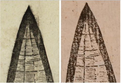 New York Times
Nonetheless, the announcement that the image would go to auction–for an attention-grabbing price–in the belief the it might win eager bids that might drive up its price further, and purchased, perhaps by an internet mogul who saw the benefit of showing his concern for public good and interest or display it in a corporate boardroom, as an early hoary icon of globalism as an icon of wealth. Despite the outdated nature of the printed terrestrial projection prided for its legibility, the huge appeal of the global gores–the inkjet version constructed by a still unknown if skilled cheat seemed destined to sell above a million and a half dollars–rested not only in its scarcity, perhaps, and its “naming” of the discovery of America, but its advancement of global legibility that has now become internalized in everyone’s phone. An earlier alleged discovery and auctioning of the same set of gores, in 2003 among the ephemera of a German book collector, the reduction Waldseemüller’s large wall maps to illustrate the discoveries in an economic format, with the help of the Professor of Cosmography at the University of Basel, transposing terrestrial expanse to a graduated scale on regular intervals of thirty degrees as if offering a window on an earlier world of mapping and the past confidence that was once held by a line and geometric order. Is the nature of the creation of the fake version a by product of a new globalization, where images circulate online and the fake/real binary distinction holds increasingly less weight?

The scan of this classic icon of an earlier globalization, even after the discovery of its forgery, offered a form of performance piece, while not original, confirming the remove of a paper map from a world that values grids–a visual epistemology of global positioning that privileges point or pixel, rather than lines of latitude and longitude that even in the past several decades have grown far more antiquated to our eyes to almost loose their sense of modernity.
 Photoreproduction of 1507 “Waldseemmüller” globe gores sent to auction
The “fake” was soon shown to be a photomechanical reproduction–and not even an engraving, after all–bears more traces of technologies of scanning and photographic reproduction, which trump the format of projection. It wasn’t only a later impression of the same plate, as claimed, despite the considerable print run the gores seem to have had–perhaps up to a thousand–but, even if the paper was in fact old, derived from a photograph, in a process that not only created a pattern of darkening and streaking not able to be created by gouged wooden plates. Was it something of an unintentional performance piece in itself, the creation or casualty of a new accessibility of images, organized on principles of appropriation more than originality?
7. The fraud remained an impressive wonder of something like inkjet printing, deriving from a screen shot or image capture that placed in a new ecology of image and new technologies of reproduction. Its aura of antiquity, most convincing in its worm-eaten margins, prefigured an age of globalism at a time when we’ve ceased to map on paper, and perhaps fooled as an early legible pocket-sized reduction of global spatial relations, with increased appeal as an early assurance of global continuity: its legible surface placed or seemed to situate new world islands within the ken or grasp of the observer, in an era when most all hold the world on the screens of the iThings and androids in our pockets–so much that access to downloadable maps are active signs of globalization.
One might appreciate how the map addressed viewers in two registers–of the modernity of projective geometry or of image capture: the faking of a map that afforded viewers with the ability to scan global knowledge circa 1500 neatly organized by a graticule on the projection of Peter Appian became a luxury fetish in an era definitely decidedly after the map when remotely sensed space is viewed by technological intermediates. The two worlds of engraving and digitization were not easily or seamlessly bridged, experts at David Ruderman and historian of science Nick Wilding were quick to detect to rely on a form of photo-reproduction, observing a set of flaws and overprinting that was not to have been created by an image on a gouged plate after all.
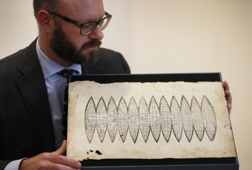 Kirstin Wigglesworth (AP)
 The New World of “America” Displayed in the Map/KKirsty Wigglesworth/AP
Despite the care with which it was presented–but because of the traces of photographic reproduction–the theatrical claim that the arrival of the map at the house created quaking at the knees given the “once in a lifetime” chance of the apparent reappearance of an object of such scarcity–one wonders how the scanned image mechanics of printing didn’t go unnoticed earlier, so distracted was the auction house celebrating the discovery. As questions immediately about the provenance of the engraving and the thickness of its imprint grew before it arrived at auction, the fraudulent nature of the map–a panoramic opening up of the world’s surface that flattened the earth’ continents, interrupted at thirty degree intervals, in a projectional format of Renaissance world-mapping, raised questions about its authenticity. So few versions survived, its extreme rarity should have posed questions for auctioneers, perhaps, but were only resolved when it was announced for sale, in ways that shifted the apparent serendipity of discovery to signs of its irresponsibility and of the forgery of the map’s antique origin.
Were the forgers unconsciously performing something of a media archeology of the original image, as their work showcased the instability of a simply scanned form, displacing and refracting the certainty of the engraved line and geometric projection? The forgers were found out quickly enough, as high quality scans of the “new” set of gores revealed a level of detail that allow them to pass as a printed surface, but betrayed their recent printing: some of the map was printed atop glue, and a trace remained of a repaired tear in one of the few other originals of the set of Renaissance gores. Unlike many earlier “faked maps” whose authenticity had been questioned, detecting its artifice lay in spying the traces of technologies of scanning, ink-jet printing and photography, and not the authenticity of the map as a document or its level of geographic knowledge. After fooling the standards of cartographical expertise honed in libraries, who judged it credible, several clues established its status as a reproduction that revealed it to be a skilled copy, especially signs of a repair one of the most digitized examples of map gores–whose torn section survived in the white space that curiously appeared in the map, in the guise of a ghostly blur.
 Gores, Martin Waldseemüller, University of Minnesota Libraries, James Ford Bell Library
Mapmakers long exploited new technologies of reproduction, from early modern engravers to the digitized images and global GPS mapping on grids. The wonders of such early images are seemingly opened by access to ink-jet printers gave a second life for early modern maps, increasing their wondrous status as objects in unforeseen ways, even if they are far removed from the craftsmanship of map making. Largely dependent on the high-quality scans of holdings of august institutions and private as well as public libraries, the availability of high-quality images–of which the cabinet of curiosities and marvels known to the world in repositories such as the David Rumsey Map Center, which offers in a mind-boggling abundance online of 82,000 images–exportable at over 100,000 pixels per sq inch–and readily georeferenced–promises virtual exploration for all lovers of early modern maps. If not a proxy for first-hand observation, the website provides a digital support structure for viewing maps, none of which are likely to be easily available for many. If few will be used for orienting us to space, the tactile relation to maps and to the past preserves a range of period eyes; the tactile relation to the maps that they preserve may even serve to provide a basis to check the extent of their skillfulness against copies. For the tactile presence of the map is enhanced by amazingly high-quality downloads, even if few were designed to privilege touch so much as Samuel Ruggles designed, at the same time as Braille first employed military cryptography to offer the blind a legible system in this 1837 map, which was created for the New England Society of the Blind, made just after Braille’s system was adopted in the United States.
 David Rumsey Map Collection/Cartography Associates
The virtual cornucopia of maps and map projections in the Rumsey collection preserves the rhetorical claims of presence in maps as it allows one to explore their space in virtual terms. Even as we seem to loose that sense of presence so laboriously created over time, in other words, more and more easily located on a map’s surface and enjoined to “manage our presence in Google maps,” the rise of new possibilities to interface with the map’s surface suggests new possibilities of its tactile presence, even in an age of Google Maps. The accuracy of reproduction offers far greater accessibility to collections of once obscure old maps, how able to be magnified and viewed in high res displays, rapid accessibility of multiple images in online archives offers a temptation to forgers–even if at the same time as it increases the ability of armchair sleuthing able to displace the authority of archival repository.
8. The immediacy of online repositories of the cartographical powers of engraved images is destined to grow even as new platforms for relaying and creating an image of space. It may be that GPS grids may weaken interest in the artifice and reading global projections, as gridded space removes the promise of continuity projections offer, or make their epistemological remove more poignant as a contrast to our own era of gridded space, where the reticulation of a gridded space leaves meridians and parallels is far less important, as satellites that circle the earth determine place–and permit a the sort of complete coverage of the terrestrial surface a piece of paper could never contain.

The precision of the grid has in a sense definitively displaced the graticule or the mental tools for viewing place on maps. It may be that the surface of the world seems almost shrunk by the web of feeds from satellites orbiting the earth. The orbiting satellites are an icon of globalization, which seem to reduce the world as continuous real-time feeds, in visual architectures increasingly removed from individual abilities of judgment, and measuring position by greater precision than we could ever hope to judge or reproduce.

Does our own visual judgement so removed form the map that a scan of an early modern map can be passed off as a discovered treasure, and the thrill of discovery for a market removed from admiration of its artifice? The comprehensive detail and multiple scales of satellite images–combining qualitative and quantitative aspects in amazingly high-res images of local detail–may have increased the aura of the very lat/long graticules they appear to render obsolete by their expansive interfaces. The determination of location on a grid has no embodied frame of reference but describes place in abstract terms, rather than by embodying spatial continuity in graphical terms.
Perhaps it will be argued, if without much grounds, that access to online versions of digitized rare maps–need to be restricted. But the real dangers of allowing continued online accessibility of old maps are not at all immediately clear, or the result of the fraud almost perpetrated by the photo reproduction of these classic map gores. The attraction of the map reminded us of its appeal to render legible the innovative compression of global information, the result of an ambitious project of geographical synthesis in St. Dié, compiling recent geographic knowledge in a new legible form, which was reproduced to accommodate different levels of detail, but situated an expansive space “America” prominently inscribed in the bounds of an unknown if newly found sickle-shaped land.

The wonder of printing was far more ornately reprinted in a copperplate engraving–enriched with more detailed topography, and suitably craggy coastlines–echoes the second edition of the Waldseemüller gores, labelling the new discovery “AMERICA NUPER REPERTA,” as a sign of its modernity and signature of its authenticity, although the image presented to the Canon of Albi. While often cast as itself a plagiarism of Waldseemüller long-prized projection of spherical cosmography onto a flat surface, the multiplication of the dense toponymy of the copperplate engraving borrowed partly from the globe of Martin Behaim, based on his Portuguese travels, but in large part from Ptolemaic maps may be a revision of a larger project of Renaissance globe-making.
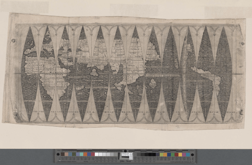 1506 Boulangier Gores NYPL
 New York Public Library (NYPL)
When the announcement of a discovery of what seemed a new edition of the gores first appeared at auction, did its appealing grow in an age when our maps are carried in our pockets, on portable devices? The expanse of the uncut paper image provided a simple and elegant graphic argument of the earth’s sphericity, unlike a UTM grid, presenting the basic Ptolemaic map projection, able to be readily admired as a discussion piece sure to inspire wonder by its owner. If it weren’t such a crassly commercial project, as well as undermining serious scholarship, the definite technical bravado in its reproduction was worthy of a sort of perverse performance piece, admirable in the ability of a forgery to jigger a trade in antique objects of few scruples: a perverse item even for a collector to entertain bidding over a million dollars; the fetishization of the paper map was truly obscene, as an object belonging in library vaults had migrated to an auction house to fetch individual bids of even million and a half dollars, at the same time as scholarly projects are defunded, and libraries’ buying budgets are regularly constrained.
Might the almost accepted forgery that was presented with such to do as a once in a lifetime discovery at the auction house, who were delighted to identify the map as a rare example of the “birth certificate” of America–the basis for its elevated price. It isn’t as if North America hadn’t existed earlier, or bestowing Vespucci’s name on a populated land was ground-shaking; wouldn’t it be nice if the projection of such an astronomical price for a recently printed piece of paper would help provoke a readiness to rethink priorities in the funding of the humanities?
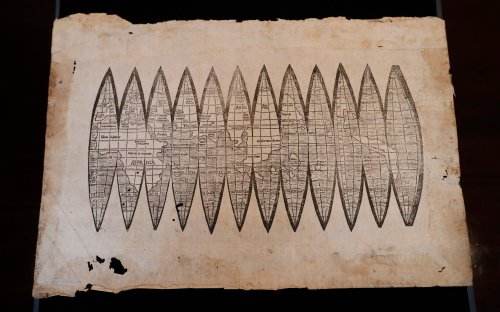 Kirsty Wigglesworth/AP
The artifice of the gores provided the power of grasping a sense of global continuity perhaps less linked to measurement than the power of cognitively placing oneself in relation to its form. But the aura of the map seemed more inherent in its yellowed uncut folio of paper–recalling the somewhat suspicious A2 size of the map found in Berlin in 2012, and rather ridiculously presented as “America’s Birth Certificate” on Independence Day–just a bit, as it happens, after the scandal that surrounded charges of a faked birth certificate of the sitting United States President led President Obama to invite the White House to release long form birth certificate online–seemed to offer a rear-view mirror of the recent rise of global positioning systems. The value assigned to the map’s clear indices of degrees, and the conjectural notion of its continents and the absence of polar snow, lay in the remove of its confidence of its totalistic coverage from the image of globalism we now derive from satellites.
 Minneapolis Public Radio News/Art Hughes/University of Minnesota
Lack of clear provenance led map experts at David Ruderman Maps to compare the image to scans readily available online, their suspicions already alerted by its pretty heavy ink and the mystery of its sudden surfacing in the auction house. Online scans may well have offered a basis for reprinting the image of the planisphere on suitably antique paper; its printing created the problems of reproduction that allowed the forgery to be quickly spied, and a repaired area where the gores were torn was transferred to one of the ellipsoid gores, replicating an otherwise inexplicable trace on its surface that close comparisons readily revealed, casting doubt on its sixteenth-century date because of the clear similarities of high-quality downloads of the repaired image of the gores that are housed in the James Ford Bell to the odd ink pattern preserved in a quite high-quality ink-jet printing to the left. The image to the right suggests the echoing of the new paper rectangle in the derivative image to the right.
The obscene value that was hoped to be gained by what was but a photographic reproduction almost won approval in a period eye that seems increasingly habituated to the quality of a printed version of a scan, and whose aura lay only in the mottled nature of piece of paper that it was printed–which sees an oddly “uncut” sheet intended for a book–yellowed at its margins and eaten in places distant from the gores in quite convenient ways, While the beautiful production was quickly proclaimed as a “fake” by those who observed its inexplicable similarity to a map in the James Bell Collections in Minnesota were a bit too close for comfort, causing the San Diego based map collector Alex Clausen to examine it beside readily available scans.
The resemblance in the sheet of paper that was being sold as “America’s birth certificate” by the experts at Christies indeed proved too close for comfort. The presence of the white lines that seem to derive from the scan eventually raised questions about its authenticity that somehow eluded the auction house who was ready to start bids from $800,000 for the single-sheet image and was expected to go upwards of a million dollars, boosted by media buzz and apparently encouraged by the remove of critically reading of a map engraved on paper in an age of online mapping. The astronomical cost certainly suggests not only a problem of excess on-hand cash, and the global problem of steep economic inequalities, but an unwarranted desire for the map, and its premium as one of the first maps to name America, as a trademark, rather than because of its accuracy or mathematical ingenuity: thought the counterpart to Waldseemüller’s 1507 World Map, an expansive wall map that is the first map with ‘America’ on its surface, whose sole copy has been owned since 2003 by the Library of Congress, the gores were presented as a desired fetish of global appeal. Its odd combination of the innovative and amazingly historical gained new status in a digital age as an image recently reprinted photographic copy or a laster-printed reproduction created an oddly hybrid modern artifact. Perhaps the presentation of the image as a treasure of early engraving acknowledged the diminished expectations of an era where scans predominate our period eye, or perhaps it epitomized the fraud of the map’s alleged claims to modernity.
AP/Kirsty Wigglesworth
9. Although printed on quite convincingly old paper, which, in a bibliographical oddity, seemed to retain the trace of a manuscript in its upper right corner, the uncut heavy paper convinced more than the crispness of the heavy lines of the twelve-section map, which made it quite unlike most artifacts of early modern printing and should have set off early suspicions. The printed map moreover contained a crease, intersecting one of the ellipsoid gores, as the copy in the James Ford Bell library in the University of Minnesota, where a patched tear in the image reproduced in the fake woodcut revealed it a scan and a scam, if one cleverly forged. But is the forged item–perhaps the trade of globalization–if not the distinction between the original and copy not questioned by a globalized world? The display of the image to online observers provoked discovery of flaws in the image billed that was quickly exposed as impossible to be the created by the school of St. Die. But despite the importance to clarify the provenance of the map, the dismissal of the copy is as much a reaction to globalization, where the manufacture of copies is so often performed to force one to question the binary of fake and original, and where the copy may often force the “fake” to be recognized as often being its own reality.
Both the “original” global gores and the photographical reproduction, in other words, might deserve to be taken taken as the products and icon of two ages of globalization. There is a certain sense in which the aura of the engraved image has gained a new authority by its antiquated promise to scan across the surface of the inhabited earth in twelve ellipsoids, a reconciliation of perfect geometry with the earth’s curved surface, that we are still working to devise solutions for scanning the geotiffs taken by micro-satellites that ring the actual world to provide high-resolution images of its surface.

To be sure, modern gores exist–organized by cloudless daylight topographic views, and now the icy poles–for now still present–included, and acknowledging its ice-covered polar caps–

The crafting of a modern version of global gores to preserve sites of memory of the blood-spotted current age of globalization might more accurately include sites of genocide–and command attention as such, even when painted on plywood:
The reproduction of the map matches the excellent high-res images available from the Regents of the University of Minnesota. If the scan wasn’t such a clear case of fraud, could have been passed off as part of an extended art project or performance piece. It had certainly fooled the eyes, and embarrassed one of the most esteemed auction houses who had certified its authenticity in London, who pronounced it authentic after finding it a perfect match with a version in a state library in Munich, which was itself been bought for $1.2 million in 1991, and which the state library is now compelled to reevaluate. (That map appeared in the estate of map collector H.P. Kraus, and was accepted as an original print; the current fraud was also passed off to the auction house as from the estate of a deceased paper restorer to manufacture a slightly credible provenance.) It now seems more likely that the first time the ink-scan forger seems to have struck. But the performance of the reprinting from the original set of woodcut gores housed in the James Ford Bell Collection reveal unsavory exploitation of the high quality scans of the map the library displayed online.
 James Ford Bell Library, University of Minnesota: http://www.bell.lib.umn.edu/index.html
The same image was reproduced in other, slightly different, forms, as it had long enjoyed a particularly promising press run, given the huge interest that the unique map gained as a reproduction, either as a flysheet or as able to be included in a book in relation to which its fairly detailed toponymy might be read.
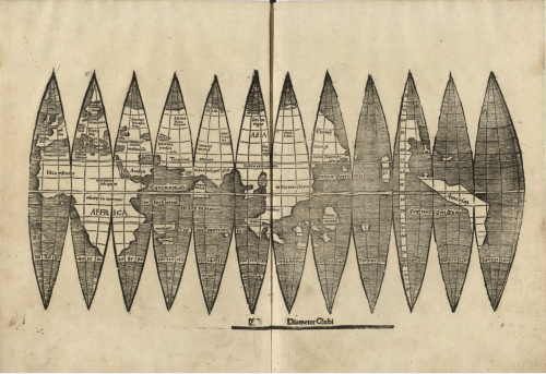 Library of Congress
But the value of the performance piece of the production, which seems an inkjet print from a photograph, was not subjected to the sort of rigorous analysis of ink that occasioned Yale University to devote attention to some serious spectral analysis of the chemical content of the ink of the Vineland Map in order to determine its authenticity, using stereomicroscopy to create x-ray diffraction spectra to detect tell-tale traces of titanium in the map–in one of the greatest roll-outs of an antique map back in the golden days of university publishing. Translated from the practice of digital scanning back into the terms of Renaissance cartography, what was shocking in the fraudulence of the faked reproduction was the absence of continuity that the scan of the copy of the map that was located in the James Ford Bell Library reveals, and the interruption that a glued patch of the map created in the alleged version that recently almost made it to auction–until the comparison to a high-quality scanned version revealed the odd survival in the copy (shown below right) that the scan was not able to conceal or erase. The accuracy of the scan, in other words, contributed in crucial ways to allow detection of the fraud.
The fraud revealed difficulties betrayed through high quality scans. The evidence of scanning and skillful techniques of reproduction that were in the tell-tale repetition of a glued portion of the Waldseemüller forgery was not not the originality of either the parchment or the ink, the telltale signs of the Vineland Map once ballyhooed by the Libraries of Yale University, who had promoted the discovery of the map as evidence of the new standards of evidentiary techniques of cartobibliography. As we’ve become good at detecting the manipulation of high-quality scans–and as Nick Wilding, the historian of science who confirmed its absence of authenticity, given the presence of the white line at the place of the patched-up original–the scan has become the premier mode of reproduction. But if not an art form, the sense of bridging two worlds simultaneously with claims of modernity was echoed in the sort of “counter-maps” that Bull.Miletic began some time back by playing with the technological support by which a Renaissance map could be remade for its viewer to reference consciously the new sorts of observation, by using ink jet techniques to create a material artifact by reordering mapped space through the tiles of a scanned image.
10. The centrality of the act of reproduction was treated as art practice by the media archeology on offer from Bull.Miletic, a Norwegian-based collective trained in San Francisco. The two artists, Dragan and Synne, perform a more explicit media archeology on the most classical of Renaissance images from the perspective of the relays of information in a digital world. The collective scanned an engraved image of Venice that was designed with considerable enterprise by Venetian painter turned printmaker, to invite the viewer to admire Venice at the height of the Renaissance in order to ask us to meditate on the intensely mediated nature with which we consult digitized maps today, removed tactile form of mapped space. In order to create the perceptual remove that they suggest exists in a tiled space, the two artists of Bull.Miletic–Dragan and Synne–famously remade identically sized copies of the Barbari map, transposing an icon of modernity by its digitized–rather than its paper–form. By exploiting the operations of digitized images to disrupt the continuity of the panorama of Venice through a computer glitch, Bull-Miletic scrambled the tiles of the engraved view of the lagoon city, originally engraved on six large sheets, to fragment one of the largest magisterial woodcuts ever made at that time, re-rendering the encomiastic image of the city’s architecture to remind us of the technological platforms that support the image-files that form the basis of our own maps, by revising the “tiled” nature of the digitized view designed by Jacopo de’ Barbari in what seem feedback loops, resizing its tiles into tiles of smaller dimension to make them fail to line up in continuous form, showcasing the instability of a digitized image by fragmenting the elegance of the engraved line.
 Bull.Miletic, VENETIE MMXVII (1500-2017), inkjet print on paper, 52 1/4 x 109 1/4 in. (sheet) 60 3/8 x 118 1/8 in. Courtesy the artists and Anglim Gilbert Gallery
 Detail from above
The resulting displacement of the coherence of the virtuosic perspective view destabilizes the viewer who stands in relation to the retooled digitized image of Jacopo de’ Barbari’s multi-sheet wall map, which proclaimed the architectural harmony of the city. The displacement of individual tiles within the scan of the Barbari map aptly reminds modern viewers of the distance of our own world of images from when Jacopo de’ Barbari supervised the engraving of three versions of differing content which assemble multiple individual sketches of the city taken at elevation points of some 130 towers, to fashion a unified a perspective that transport the viewer above its actual space If the Barbari engraving worked to achieve a coherent view of Venice beyond current practices of surveying, in an image that continues to attract viewers’ attention by its organization of a receding perspective on its dense urban architecture, Bull-Miletic disrupted the skill by which its surface opens streets, bridges, houses, and ships–and even individuals–before eyes, in an Apollonian perspective that compels our eyes to pour over the surface of the city presided by Mercury, God of Commerce, acknowledging the favorably-situated “emporium” [faustus emporium] as a feast for the eyes–

If the “favorable situation” of the city is a reference to its privileged position at the mouth of the Adriatic, and a hinge to ships from the east, the woodcut affirmed the propitious location of Venice even as the new world was first known in maps of far greater expanse. The six engraved plates that compose the imagined aerial perspective celebrate the identity of the improbably lagoon city as a center of culture and Mediterranean capitol, which despite its site of exile on the edge of the Adriatic arose from the waters, as Neptune on the back of a dolphin, as a site of architectural prominence that the clouds themselves seem to part to reveal, the conventions of wind heads that were more familiar from charts and global maps now seeming to announce the prominence of Venice, by 1500, on the world map. (The combination of conventions of nautical charting and global mapping in the engraved multi-plate aerial view seem almost a reference to the curiously combined global prominence of a city whose wealth derived from the taxes of expansive Mediterranean maritime trade, revealed by ships that have visibly clustered near to its customs’ house.)
The elegantly engraved wall-map is indeed a visual wonder when scrutinized at first hand, inviting observers on imagined itineraries of the city, from a single position; one can walk with eyes down curving streets from the Piazza of San Marco, the imposing bell tower still the city’s center, or snake along its Grand Canal, as it creates a compelling sense of presence and so cunningly conceals its own artifice; even if the seams of individual blocks of the large sheet of Jacobo de’ Barbari’s woodcut engraving can be discerned, the overall sense of wonder leads one to a suspension of doubt and belief.
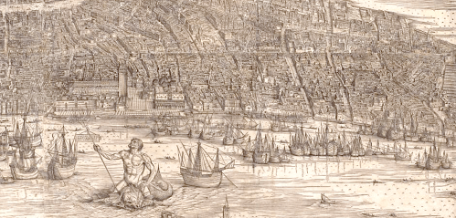
Jacopo’s expansive print afforded wonder at its assembly of a transcribed record of space, if it also offered a vicarious motion through place–it is hardly cinematic, but suggests a sense of spectacularity. It allowed viewers to grasp Venice by the totality of its magnificence in an image distilled in a single frame; his shop sold the image as a multi-sheet wall map, for display in the interiors of homes, hallways, or public spaces, allowing it to be poured over as a discussion piece, in ways that must have set standards for talking about images by describing their construction and detail. It has been compared–not entirely wrongly, but improbably and confusingly–to the Google Earth ‘of its day,’ offering a sort of virtual inhabitation of space. But it foregrounded the manual and mechanical craft in its visual vocabulary–evoking a tactile sense of the lapping of the Venetian gulf on its shores–rather than a disembodied perspective or remove, and existed for visual pleasure, but to make a point about the prominence of the lagoon city in a global space and market: the foreshortened city opens each building and street to allow the viewer to navigate and inhabit an urban space, its oblique perspective offers an invitation that few viewers could resist, that clearly surpassed the tools of surveying employed to create maps of terrestrial space.
The six plates Jacopo de’ Barbara engraved collectively orient viewers to indulge in a virtual–inhabitation of space, inviting one to pan and zoom into streets, houses, and individual detail, foregrounding the artifice of manual and mechanical craft through the continuity afforded by an imaginary point of view by uniting a transcendent perspective.

The widely reproduced image continue to be widely reproduced to invite a performance of the reproduction of the widely reproduced image–shown above in a somewhat sepia filter–that the interruption of such an invitation was somewhat chillingly played with in the below reproduction that does the reverse of its inventor–by allowing tools of computer imaging to force the tiles of the scanned map to not line up and integrate in a seamless sort view. In ways that combine Duchamp with video artist Nam June Paik, Venetie MMXVII updates the five-hundred year plates of “Venetie MD” by interrupting their continuity.
Bull.Miletic thematized their repeated, intentional interruptions, which became the subject of their own media archeology of the present moment, in ways far more apparent the seams between the original plates, in order to create an image of dislocation in place of an encomiastic image of place. An image of placelessness in the age of the digital reproduction, the map is an image of the new interface of digital images rather than the architecture of Venice, which is now blurred beyond recognition save as something like a machine readable image of the Grand Canal, obscuring the alleys and rioni that were so invitingly detailed in the Barbari map, disrupting the artifice of spatial recession that addressed the viewer’s eye by the seams of each tile that fail to line up.
 Ve60 1/3 × 118 1/8 inches; 153.2 × 300 cm)

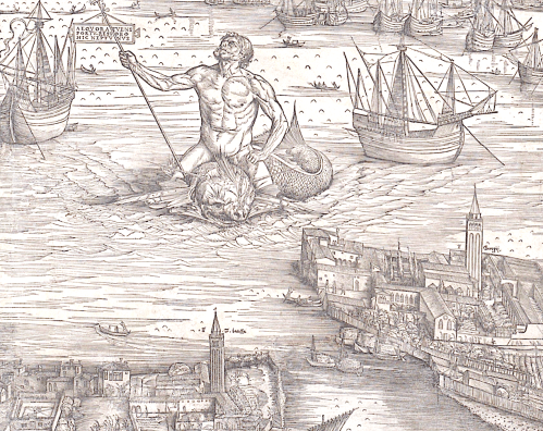
Inkjet versions mechanically distort Jacopo de’ Barbari’s engraving of Venice in the project “Venetie MMXVII“, in three stages, dissassembling the ordered space of the original in inkjet images equal to the original’s size, that engage the practice of a mechanical disassembly of the engraving to remind viewers of the assembled–or tiled–nature of downloads of the scanned Barbari map, as if to reconstitute Venice as a place.
Each of the three versions exploit the scan to foreground the digital processing of the woodcut, revealing the viewers’ dependence on the mechanical assembly of a map, as if to suggest the new models we have of assembling a continuous space, or what passes for our perception of continuity. By not imitating the original map of the city, but exploiting bugs in its mediated sense of coherence, in translating pixellated ties to tiled image, they exploit the division of the map into over 16,000 tiles–a gird far more complex than the original six sheets–to disrupt the attention of viewers, if not the fragmentation of a coherent space. The inkjet printing allows them to fashion an alternate use of the individual tiles inherent in the assembly of digitized images, disrupting or appearing to disrupt a measured grid, so that rather than aligning perfectly or harmoniously, the 256×256 png files are fit into smaller, 128×128 frames, although the recognizable image of the city–and the engraving–is preserved, perhaps because of its prominence in our memory and minds. Venice is, indeed, a city preoccupied with fakes and counterfeits, not only as a point of resistance to the expansion of globalization–
 Ivar Hagendorn

–but also in order to conserve its cultural patrimony–

In Venice, the Barbari map preserves a pristine image of the city’s Renaissance cultural glory, and a prime currency of artistic grandeur in which the city trades. The tiles of the digitized version of Jacop de’ Barbari’s multi-plate perspective view of Venice intentionally–if symbolically–echoed the division of the plates of the woodcut’s eighteen separate blocks, to remind one that the medium is the message. For rather than meshing in continuity, the tiles of a computer scan fail to jibe to create the wonder of the aerial view, but fragment its pictorial space: the mechanical practice of image-making call attention to the technological translation of images, and to the wonder that translation continues to hold: the result is a counter-map, and finds its artifice along other deals than coherence,; it seems so uncannily to shift the map from one regime of modernity to another t0 invites us to inhabit two distinct spaces at the same time.
Bull.Miletic, VENETIE MMXVII (1500-2017), inkjet print on paper, 52 1/4 x 109 1/4 in. (sheet) 60 3/8 x 118 1/8 in. Courtesy the artists and Anglim Gilbert Gallery
The inkjet economy encourages experimentation with an image whose tiles–whose scans downloaded in png files disrupt as much as reproduce what the woodcut sought to knit together in an imagined sense of continuity. The forces us to attend to the technologies of reproduction that made the networked nature of the image a source of its cognitive instability, as in a final iteration of the image, printed as the size of the de’ Barbari’s original, which reordered its over 11,000 tiles in an entirely randomized sequence, as if to jumble its ordered space by rendering ‘place’ illegible in an iteration that recalls a black-and-white television’s static, suddenly rendering the city that the engraving once championed illegible, save in isolated glimpses of the original perspective view.
 VENETIE “C”, 1500-2017, inkjet print on paper (60 1/3 × 118 1/8 in; 153.2 × 300 cm)
Rather than reminding of the insane economy we live in in which someone would plunk down a cold million for a sheet of paper, the inkjet images exhibited at the Venice Biennale play with of the fuzzy fragmentation of a promise of tactile access, and the acceptance of the second-nature tiles by which any map assembles itself before our eyes, often depending on download speeds, in web-based maps, and the multiple technological scaffoldings by which maps operate as they circulate in digitized form. In place of the seamless whole, the seams of the image are expanded to situate wonder in the fracturing of its legibility, if providing us with a legible surface of a very different sort than could have been experienced by the map’s original designer or by a Renaissance period eye.
 Bull.Miletic, VENETIE MMXVII (1500-2017), inkjet print on paper, 52 1/4 x 109 1/4 in. (sheet) 60 3/8 x 118 1/8 in. Courtesy the artists and Anglim Gilbert Gallery
Wondering what sort of arguments they make about our perception of maps, and our perception of space, seems to be the point of Venetie MMXVII, however, rather than wondering how high a bid a piece of old paper can be counted on to bring at the auction block. But if our period eye shaped by the wonders of the ink-jet reproduction may be tied to the aura of early mechanical reproduction, scanning the surface of the ink-jet surface seems sufficiently impressive to demand trained historians to remind us of their remove from the technical practice of engraving to discern the sorts of skills by which early maps promised to communicate a visually continuous holistic image of the world, and perhaps the difficulty of recuperating that holism in a world where we map by point, and look at pointillistic maps to see if any harmony still remains in their contents. The passing off of the falsity of the set of worm-eaten gores may suggest the superseding of the project of mapping on a graticule, in similar ways, if far more deceitful in their use of digitized images to manipulate the excitement of the antiquarian marketplace. They similarly suggest the destabilized authority of the map, where an economy can exist for a faked set of allegedly ancient maps, and the ability of belief in the recurrent recovery of a lost icon can obscure the warranted skepticism so fully to leave questions or terms like authenticity poised at the edge of the dustbin of history.
Kirsty Wigglesworth/AP

