
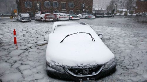
Even in an era when waking up to weather bulletins provide a basic way of orienting oneself to the world, the arrival of the bomb cyclone in the early morning of January 4, 2018, along the east coast of the United States, commanded a certain degree of surprise. For those without alerts on their devices, the howling winds that streamed through the streets and rose from rivers provided an atmospheric alert of the arrival of streams of arctic air and snows, creating something called “white-outs” in highways along much of the eastern seaboard that paralyzed traffic and reminded us of the delicate balance over much of our infrastructure.
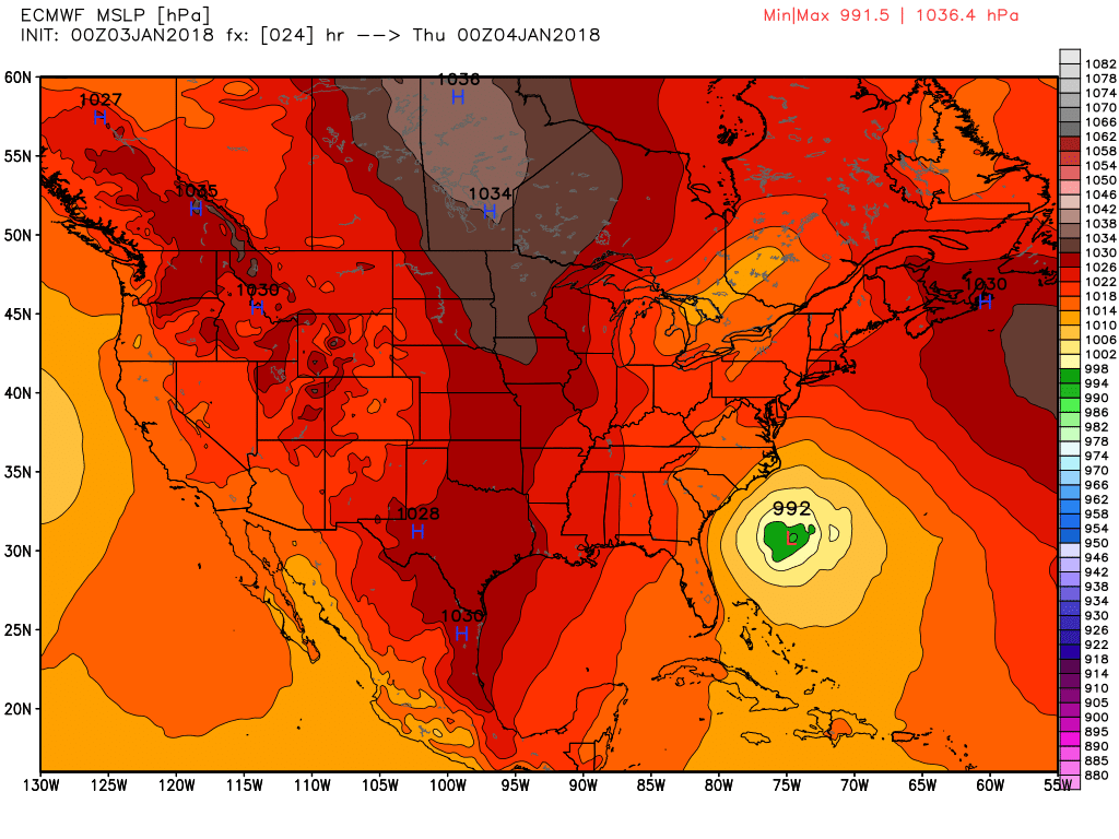
The effects of the arrival of a low pressure system in the western Atlantic created effects that cascaded across the nation, setting temperatures plummeting and winds spewing snowfall as the extratropical cyclone was displaced off New England, and propelling snow over the east coast from what was an offshore weather disturbance. While the “bomb cyclone” sounded portentous, the actual explosiveness was perhaps not felt at its eye over the Atlantic–
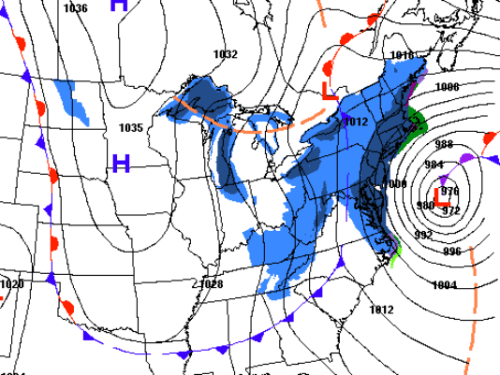
–as the bomb-like burst of pressure scattered snows through howling winds across much of the coast, but rather in the unbalanced distribution of snowfall across the nation that it so quickly created. The cyclonic winds of the “weather bomb” could not be localized: their effect was to set off a burst of precipitation, chilled by arctic airs, remindeding us of the delicate relation between land and sea in an era of climate change, when we are apt to feel the effects of colliding air masses across the country, as far as Tennessee or Ohio.
The bomb created a deep oceanic disturbance in the dissonance of sea-surface and air temperatures, and triggered the increasing imbalances of the distribution of snow across the nation, as if inaugurating an era of the increasingly unequal levels of snowfall, as a bomb that seemed to burst over the Atlantic sent snowfall flying across the east coast–
–in ways that led to a deep disparities of snow and ice levels across much of the country, where much of the nation’s western states were surprisingly free of snow, increasingly rare save in several spots.
The bomb cyclone spread across a broad surface of the eastern seaboard and Gulf of Mexico, as the areas that stand to be open to gas- and oil-speculation suddenly took a far greater hit than was expected, raising questions of the arrival of extreme weather systems as sea-surface temperatures grew: the kink in the Gulf Stream created a swirl that sucked in arctic air and spread clouds of snowfall across the eastern seaboard as the seas became incredibly stormy, driven by hurricane winds. The bomb cyclone wasn’t a major disaster, but seems a wake-up call of the charting of minerals stored in the seabed of offshore areas in the Outer Continental Shelf off the United States–the “federal lands” that the government decided since it administers directly it may as well start to lease.
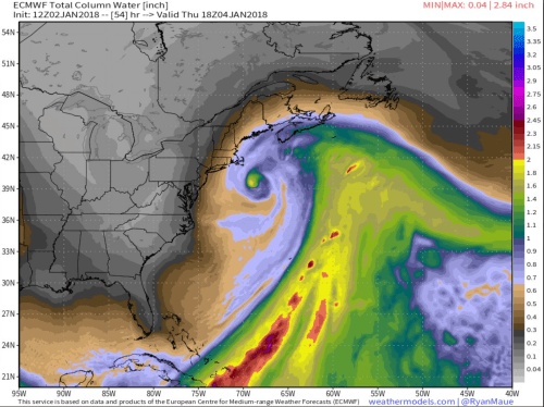
Precipitation Column Rising from Offshore Winds, January 2-4/Ryan Maue
The “bomb cyclone”–known also as a “weather bomb,” created buzz manifested in the emphasis on the first word seems far more apt–seemed something of a collective reorientation about the weather, and at weather systems that seemed decisively out of whack. The term itself, if standard meteorological fare, and quite precise, triggered shock, even in an era when we are hardly surprised by extreme weather, from mud slides to apocalyptic out of control fires to hurricanes. But it registered shock by its new scale and magnitude, and the sense that we were unable to control the cascading effects of a kink in the Gulf Stream waters that spun out of the eye of the winter hurricane that suddenly took form off the coast of New Jersey and Maryland, whose mesmerizing rainbow colors seemed to flood the entire eastern seaboard with freezing rains and high-pitched howling winds. Unlike the other disasters, we seemed to be able to map it in one place–or at least its eye–but see it spin out of control over our new winter landscape, making us realize the even more difficult to imagine the storminess of the seas.
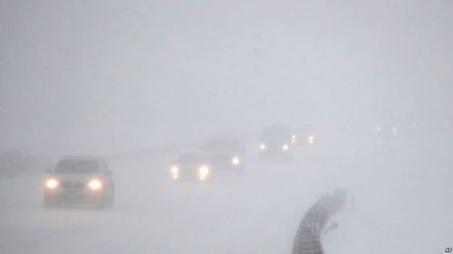 Garden State Parkway in whiteout conditions of January 4, 2018 snowstorm i
–and that left the sight of cars abandoned on freeways, as motorists fled freezing engines, or hazardous road conditions, or abandoned cars stranded in icy waters, touching sites along the entire coast from frozen iguanas falling off trees in Florida to waves crashing into the coast to flooded downtowns to strings of cars left on highways, to snarled commutes of precipitously where whiteouts caused decreasing visibility–
Barely able to keep track of the individual news stories of the day, they summed up to a sense of impotence in the face of global warming, which seemed to register a deeper level of shock, unable to be clearly processed by a map, but all the more in need of one. There was, to be sure, a deep sense of dislocation in the arrival of arctic air that spread across the east coast, sending an onslaught of waves against coastal communities and a dense wind-driven rain of snow of irregular intensity across a huge range of land: frozen precipitation, and chilling waters, unleashed and spewed out of the offshore eye of the bomb cyclone, flooding shorelines and blanketing entire states, in what became the coldest holiday on record, and flooded local news stories across the national news. But the inability to add individual stories suggested a deep disorientation in the face of climate change, bizarrely juxtaposed with the eagerness of leasing lands in the offshore federal waters that surround the nation for future oil and gas prospecting, in response to the presence of more intensive expenditures on lobbying efforts from the petroleum and gas industry than since 2012, a wave of lobbying from the very sectors–the American Petroleum Institute, natural gas, coal, and pharmaceutical companies that funded a big chunk of the unexpected inauguration of The Donald by donating over a million apiece, followed up by a board meeting the oil industry American Petroleum Institute held with Interior Secretary Ryan Zincke at Trump International Hotel in Washington, DC March 23, 2018, to Zinke’s meeting with coal executives of the National Mining Association at Trump’s DC Hotel, or an invitational the U.S. Chamber of Commerce held at Trump National Doral in Miami, managed by Eric Trump, with firms from the National Mining Association to Chevron. The same man who insisted that “global warming” ceded lexical prominence to “climate change [since it] wasn’t working too well since it was getting cold all over the place,” again revealing a confusion between climate and weather, the falling coastal temperatures offered a way to dig into climate science, even as the fall in temperatures revealed the unstable weather systems that will reshape coastal weather.
There was a pronounced absence of attention at meetings at Trump properties that set the stage for rejecting protections on offshore “federal lands”–now termed “tax-payer owned”–by maps of offshore leased lands. The removal of all safeguards against drilling the Outer Continental Shelf led Zinke to praise “bold and decisive action to end the War on Coal and put us on track for American Energy Independence” through a review of the moratorium that existed on leased coal mines on federal lands and rules on oil and gas. With the removal of restrictions on prospecting on both federal and private lands in the Outer Continental Shelf, the future of leasing now conjures up disastrous images of offshore unplugged leaks, not just a far-off region beyond the three-mile periphery of state-owned submerged lands, but rendered all the more nearby–as massive resistance to the proposal to leasing submerged lands in the OCS spread in the coastal communities the they stand to threaten.


While the meteorological effects of the fall in air pressure cascaded across the entire east coast, we depended on individual stories–flooded downtowns and storm-driven waves; traffic accidents and snarls; frozen pipes; abandoned cars on highways–a map seemed scarcely able to comprehend their scope. The extent of our unpreparedness for its arrival seemed to mock the obliviousness of the president to global warming in relation to weather changes. President Trump had marveled as if with utter obliviousness that New Year’s Eve 2018 seemed “the coldest on record”–COULD BE!–in his preferred all caps, as if in a mockery of the all-caps National Weather Services bulletins of old, but a few days previous. Trump took time out from governing to hope for a “bit of that good old Global Warming,” a mocking tweeting that seemed to reminisce about an old friend, urging the nation on December 28 to “bundle up!” without offering much other help.
Trump’s tweet suggested his deep dislocation from our own extreme weather. If he had been spending a huge amount of his presidency at Mar a Lago, he unconsciously reminded the public to take care of themselves, as if leaving unspoken they should not expect help from his own pro-extractive industry agenda that had already mapped the offshore for future prospecting. The blitheness of Trump’s comments reveal less clever camaraderie than willful ignorance of relations between weather and climate, or extreme temperatures and global warming. Trump’s ill-timed tweet became only more disorienting over time as the bomb cyclone arrived; it would remind the nation, yet gain, of the consequences of his refusal to foot a larger bill for a nation that released the most greenhouse gasses, as snows filled an east coast extending to Indianapolis; its obstinacy recalled decisions of Trump’s team to curtail measurement and collation of global warming and sea-level rise in the Department of the Interior–if not a new relation to the interior of the United States last October, but expanded the wars The Donald wages against the public record, in attempts to fabricate his own sense of grandeur in a mission to make America great again,–or at least try to think of it so, even if much of the nation lay frozen under a blanket of snow.
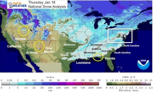
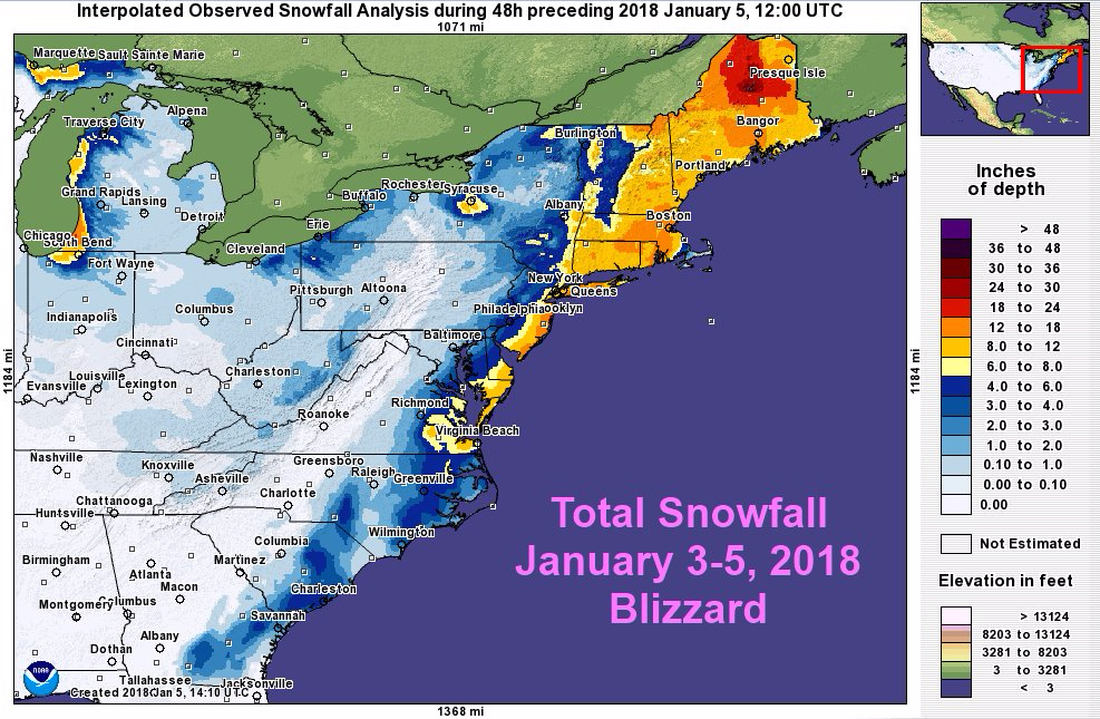
For the precipitous drop in air pressure that occurred before the bomb cyclone dropped as cold weather moved up the United States’ eastern seaboard reminded us of just how volatile are temperatures–and how hard it is to tell a clear story about them–in an age of increasingly high sea surface temperatures. As the polar vortex uncorked record low temperatures across the east, the bomb cyclone spat out waves of precipitation, exploding over the eastern seaboard spewed snow by a spate of howling winds–even if the seas remained oddly tranquil in an interpolated visualization of “observed snowfall.”

–in what was one of the most intense coastal storms to appear in mid-winter, whose hurricane-force winds were driven by the most extreme weather event created off the eastern seaboard in winter. FOX, predictably perhaps, came up with a slightly different graphic based on the same data, making the intensity of snowfall seem so many delicate wintery flurries– but also showed the seas as being fairly tranquil, less a “white-out” than a wintry scene worthy of Hallmark.

The violence of the gale-driven snowfall was an effect of increased sea-surface warming of even just a few degrees, magnified by the fall in pressure systems that sent frigid winds whistling across the continent that one could no longer map into blue and red states, so overwhelmed was the nation, effectively, by warming ocean temperatures, and so helpless we would be to watch the arrival of arctic temperatures over the Atlantic, with high winds in a winter weather phenomena expected only to grow over time.
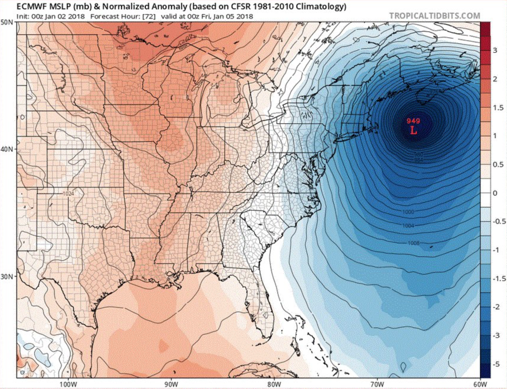 Air Pressure Deviation from 1981-2010 Climatological Record
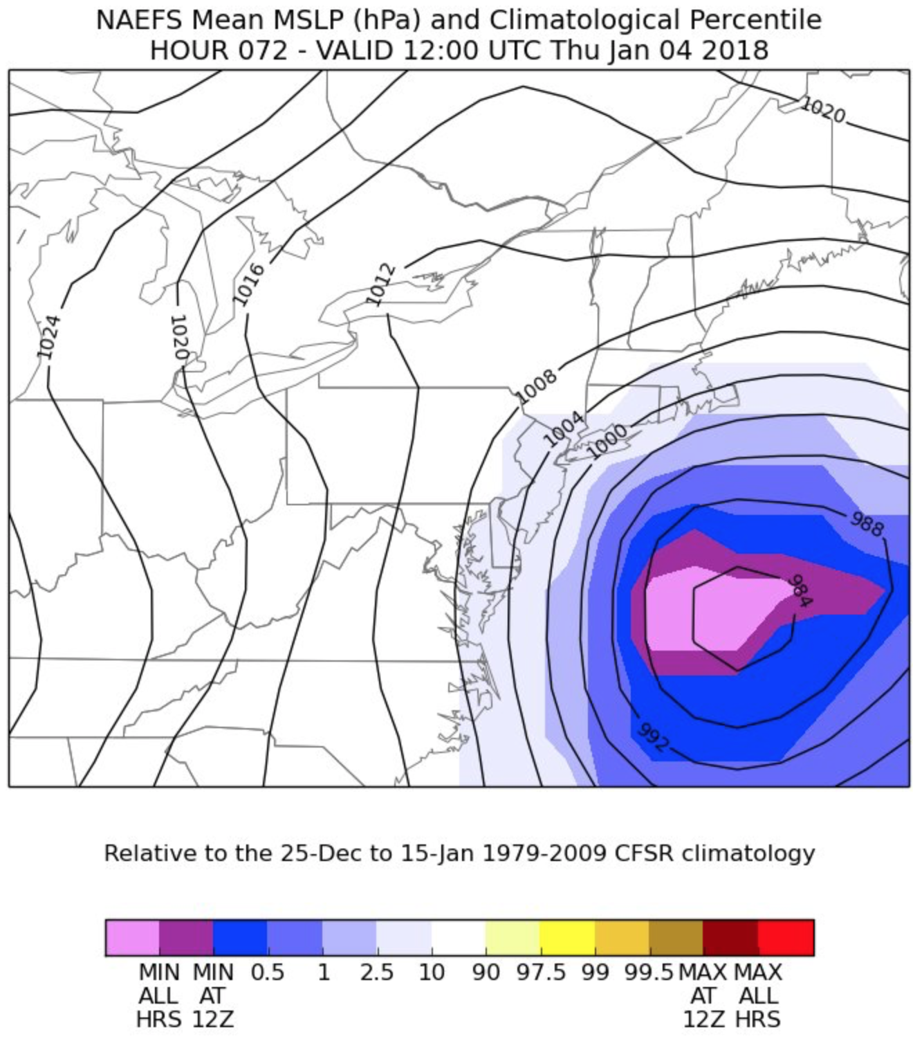
Air Pressure Drop in Relation to 1979-2009 Climatological Record off Eastern Seaboard
The irregular air pressure drop created a cascade of precipitation, which spun across the east coast to fill the air with snow. The new contours of snowfall from January 2 to January 5 announced the start of 2018 at a new level of intensity with huge amounts of snow moving in from the sea, as if to end distinctions between north and south, leading our supposed President to renew his 2012 winter call from New York City that “we need global warming,” as if there were an adjustable thermostat that early November over which humans were in charge. The arrival of future winter hurricanes intersect precisely with the areas of prospective future offshore-leasing for oil and gas prospecting and fracturing that stand to create increased stresses on rigs that they are not adequately able to deal, especially after the deregulation of protections intended to prevent accidents as those caused in the Deepwater Horizon rig, where an equipment malfunction led to a multi-day oil plume the was unable to be capped with particularly disastrous environmental consequences.
1. The legibility of these fast-arriving snowstorms was not quite clear, but generated a spate of maps. The story of such a sudden shift in weather didn’t follow a clear narrative, but unpacking its occurrence begins from refusing to deny its relation to climate change: the blizzards unleashed by the bomb cyclone that emerged off the east coast dropped less as an unexpected bomb than a culmination of deep changes in sea-surface temperature. The description of the winter hurricane–soon named Grayson, but clear on maps before it even had a name–may have evoked fears of a strike launched not by terrorist attack, for which it was mocked by newscasters, incredulous at the objectivity of meteorologists’ identification of the sudden pressure drop, but by warm sea-surface temperatures that created an extreme weather event that seemed to punctuate time and paralyze infrastructure.
The effects of rising temperatures in the Gulf Stream quickly cascaded across the entire east coast, sending snows to blanket much of the near lying states and waves to crash against the shores. The bomb cyclone, far from an anomaly than a symptom of global warming, invited us to show on the shifting relations of coastal weather to global warming, but of place to expanse, examining the spread of snowstorms on weather charts, and to scramble to learn the lexicon of meteorology to process the effects of climate change. The already cold temperatures of the winter suddenly plummeted with the disruption of weather systems across the coast that were hard to map save as a shift in weather systems, leaving streets flooded in storm waters and snowplows shoveling more white stuff than they had seen in recent months in a blizzard that started with cold weather in southern states, but grew with dropping air pressures over the Gulf Stream around an eye off the coast that sent howling winds of arctic air plunging below zero and sending snows as far west as Chicago and Knoxville as well as Birmingham, quickly plunging much of the east into subzero freezing temperatures with unearthly rapidity, captured by NOAA’s newly launched GOES-16—the most advanced weather satellite NOAA ever launched—which locked into position only this past December, making it a sort of test case observation for the changing character of winter storms over ever warming oceans, able to trigger storms able to send larger and denser snowfalls when meeting cold air, sent by hurricane-force winds across coastal regions.

The irregularly warm oceans generate huge pressure changes once they meet cold air. Hence, even if 2017 was the second warmest years on record–even if the only “warm” year without El Niño to bear responsibility or shoulder the blame for increasingly warm ocean temperatures–

–an already cold winter was extended by the gusts of wind released by a kink in the meander of the warming Gulf Stream, running against cooling air to generate a sudden “bomb cyclone” able to blanket the coastal regions with snow and pound the near-shore area with unprecedented force. Perhaps distracted by the driving winds that streamed snow and freezing rain across the east coast, we barely mapped the turbulent Atlantic whipped by hurricane gales creating increasingly rough seas in a future of intense winter storms.
2. The shift in weather systems eerily foregrounded how Interior Secretary Ryan Zinke took it upon himself to direct the nation’s attention to as “our” submerged territories in the Outer Continental Shelf, or OCS, just days before. President Obama had sought, if, to be sure, in a somewhat last-minute move, to affirm offshore areas off-limits to oil speculation; but Trump’s fairly recent executive orders have called for a review of geological and geophysical exploration of the Atlantic coast created something of a new grounds for speculation in the OCS, dramatically opening up seismic permit areas in the offshore submerged territories in ways that would make the federal government the lessor of five-year plots for energy exploration up and down the Atlantic coast and in all “federal waters” outside of a three-mile margin of shores.
If released plans suggest a steep alienation from maritime economies, and an over-eager idealism with which new “maritime boundaries” are carved to lease submerged territories for geological exploration suggests willed ignorance of the extreme weather of warming seas, when bomb cyclones are likely to recur with even more dangerous consequences, perhaps upsetting not only our energy infrastructure, but introducing an unprecedented level of risk that still demands to be mapped onto the leasing of offshore lands. The disquieting sense of continuity with our shores, however, suggest an area open to federal leasing and of allegedly untold underwater mineral wealth, as if such submerged lands were ready primed for claiming and extraction.
 Cumulative Leased Areas in Federal Offshore Lands
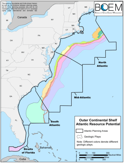
For mapping of risk is slated to expand dramatically in the expansion of offshore drilling in ways that the peaceful pastels by which the Bureau of Ocean Energy Management–a nice acronym that incorporates a wave into its logo that seems to have no sense of how extreme waves would challenge the proposals for gas and oil drilling in the Atlantic. Indeed, close ties between Trump and energy industry lobbyists who have long sought to make the Outer Continental Shelf available for exploration reveal, in disconcerting pastels, an idealized offshore of geologic plays carved out in the offshore seabed on radiotelemetry maps of the Bureau of Ocean Energy Management, whose placid colors hide the unruly oceans likely to be a regular feature of future winters.
 Draft of 2019-24 National OCS Offshore Leasing Program/BOEM
In an alternate universe, the arrival of the bomb cyclone might well have served to explode Secretary Zinke’s eager expectations to “streamline” practices of oil and gas extraction of the offshore area, as if this activity were essentially democratic, and to work to open offshore areas to five-year leases of “submerged lands” to his extractive industries. This was all part of the charge for energy independence Donald Trump promoted on his campaign, although it was far more explicitly underwritten by the very groups of lobbyists–this time from the oil and gas industries–whose presence in Washington Trump had promised to reduce. But the executive orders barely ruffled a feather. The Trump administration has been particularly keen in expanding drilling rights he had arrived in Washington, DC to affirm. By removing the so-called “bans” on coastal exploration of submerged lands for offshore drilling–euphemistically describing “energy exploration,” in a misleading language of energy lobbyists, the administration seeks to create a new orientation toward our coastal waters,–even slimily trying to buy off coastal states by promising them a cut of revenues for leasing offshore lands.
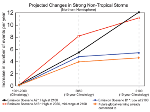
The long-planned expansion of energy exploration would expand the two million acres of oil and gas leases that existed in 2014 for potential extraction, exposing any offshore region possibly holding petroleum, in the Accessing Strategic Resources Offshore (ASTRO) Act, including the Arctic National Wildlife Refuge, without due process or public oversight, and voiding all National Marine Monuments, which are cast as obstacles to energy “development.” But on the eve of the bomb cyclone, as winds whipped the waters and blocks of ice floated down freezing rivers, the very planned seemed evidence of an extreme alienation from the ocean–or the generation of bomb cyclones off the Atlantic coast in a future of intense offshore winter storms, in which the number of offshore wintertime cyclones dropping huge amounts of precipitation may by all accounts to continue to increase in the Atlantic–as by all accounts it quite suddenly has, in simulations that suggest the increased frequency of intense climate-driven cyclones, and describe “storm tracks . . . shifting northward and the strongest storms are likely to become stronger and more frequent.”
Weather Underground/U.S. Climate Impacts Report
Rather than the extraordinary snows being an outlier, provoking extraordinary oil shortages, frozen pipes, and flooded downtowns of coastal cities that challenged local infrastructures, the even seemed emblematic of the temperature changes to come? Did the bomb cyclone, which released hurricane-force winds off the Atlantic, show how deeply the desire for opening submerged lands for rapid leasing suggests something of a deep death drive? Freud had famously adopted in the 1920s the conceit of the “oceanic” as a subjective contact with the eternal, a feeling quasi-religious outside perceptible limits; maps of the sudden appearance of a bomb cyclone from a kink of the Gulf Stream put us in all too concrete contact with oceanic manifestation of global warming creating one of the largest continuous weather systems in recent memory: warming waters of the moved up the Atlantic coast to encounter cold air off the eastern seaboard on January 4, 2018, creating a drop in pressure uncorking levels of unprecedented snowfall and tidal flooding from Maine to the southern states, driven by cold, arctic winds. If the January 2018 bomb cyclone didn’t exactly explode, it exposed an alienation from the warming oceans throughout the current government and Department of the Interior, and deep despair for inhabitants who stand to face increasingly disruptive weather systems. The potential disasters of offshore drilling rigs opening up streams of oil or natural gas seemed akin to a death drive–not only for safeguarded whales, dolphins, corals, sea-turtles and fish, but for the risks of environmental disaster that would change the coast as we know it. For by eliminating any safeguards on drilling in federal waters–waters the site of some 589 oil spills between 2001-15–including a spill in Alaska’s Chukchi Sea–the increased risk of another offshore disaster invites leaks in leased areas.
The announcement of renewed Atlantic drilling prompted something of an immediate resistance, encouraged by increased fears of oceanic pollution for shore-dwellers, fearing expanded offshore rigs in the face of an increasingly turbulent ocean surface, belied by the recently drafted plans for mapping open zones for oil and gas leasing.
 Swath of coastal Atlantic Bureau of Ocean Energy Management made available for drilling
The spread of the storm certainly demanded new visualizations of seabed tracts in federal oceans open for public leasing for unregulated energy prospecting. The powerhouse combination of low pressure and high hurricane winds that may reveal the new relations of the local and the regional. The spread of dropping temperatures and full-force winds in augured a new relation of space, snow, and cold difficult to narrate; a kink in the warming waters of the Gulf Stream off the Atlantic shore impact weather not only on the coasts, but a shifting national space. If the bomb cyclone revealed a new relation between the site of generating extreme weather systems that spread over a huge geographic expanse, the images of coastal pollution that haunted many coastal inhabitants prompted the immediate mobilization of resistance to the proposal to expand offshore drilling and exploratory seismic blasting for underwater reserves of natural gas. If oil pipes froze and water pipes froze, the announcement of new energy exploration in the very sites where the hurricane winds were strongest raised deep fears across the eastern seaboard.

3. Although time sequences are difficult to visualize, visualizations of the appearance of the “bomb cyclone”‘ capture the rapid expansion of its intensity and impact on the land as it doubled in size in coastal waters from what seemed a small depression of pressure near the warmer areas where the Gulf Stream ran off the coast of Florida and South Carolina in twenty-four hours–
–to impact the entire eastern seaboard, as the fall in air pressure sent effects rippling over a far larger expanse than is usually affected by a single weather system–
–in ways that responded to the warming extra-tropical waters, as Ryan Maue argued, in ways we cannot separate from climate change, but indeed demand to be seen as a casualty of our changing climate and ever-warming seas.
4. Indeed, the obtuse denial of climate change as a contemporary phenomenon–seconded by President Trump’s drumbeat of repeated mocking of scientific judgement in his Twitterfeed–fails to even start to appreciate the cascading effects of warming global waters on weather systems, and the dangers that extreme weather will pose to the projects of offshore drilling that members of the Trump administration–many of whom are promoting the interests of extractive industries from the American Petroleum Institute to natural gas prospectors, and the potential billions promised by bids to lease areas of the Outer Continental Shelf. Although bids on leases were long deferred due to their potential environmental impact, and the considerable risks that they pose for local economies on the shore, the nightmarish scenarios were close at hand for coastal dwellers with slightly longer spans of memory and attention. Despite the expansion of considerable legislative and public opposition in coastal communities to offshore exploration for drilling and planned seismic blasting in response to the executive order aimed at expanding offshore exploration–evident in local resolutions, among fishing groups marked by blue fish, and in newspaper editorials that are marked by yellow diamonds–
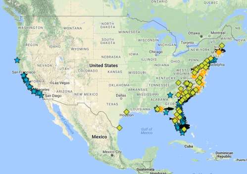 Grass Roots Opposition to Expansion of Offshore Coastal Exploration of Oil and Gas
–the opening of offshore drilling occurred in the funk of a bizarre denial of climate change.
The speed with which the bomb cyclone brought cascade of ice, snow, and hurricane-force winds across a vast array of coastal lands merited its name. The “bombogenesis” off the coastal waters so suddenly warped weather systems as it moved up the Atlantic coast, gaining an increasing disruptive intensity as it moved that seemed something like a terrorist plot on our ecosystem of anonymous perpetrators yet to be identified. Rather than a form of weather-based attack of terror, the bomb cyclone terrorized the coast in ways that revealed the deep threat to coastal communities, as well as more parched areas or those afflicted by raging wind-driven fires, of global warming. As the number of extra-tropical cyclones produced by the upper Gulf Stream are already quite common–about forty to fifty a year from September to March, or after the so-called Hurricane Season, they to stand to go on the rise, as meteorologist Maue tweeted, keeping the country informed through a range of snappy visualizations that reveal the stark pressure contrasts able to generate winter hurricanes that may be part of our new normal. if indeed the bomb cyclone was a premonition of things to come in our national waters, the announcement of expanding offshore drilling along the Atlantic was spectacularly poorly timed, and may be the immediate casualty of future bomb cyclones.
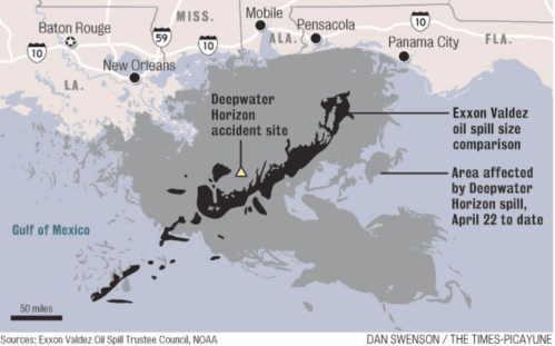
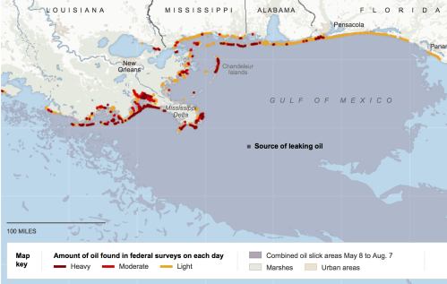
For extratropical warming waters stand to only increase in the future, raising questions of the expansion of claims to “territorial waters” as part of the nation ripe for expanding the extraction of natural gas and fossil fuels for an American administration that seems, in its insistent identification of energy independence with offshore drilling, eager to forget the lessons of the difficulties of plugging oil leaks as in the offshore Deepwater Horizon rig off the coast of Louisiana created one of the most damaging environmental disasters in United States history, spilling 215 million gallons of crude in the Gulf of Mexico, which, unplugged for three months, spread crude across the coasts of four states along 1,300 miles of shore and,with chemical dispersants killed a majority of endangered sea-turtles and reduced populations of dolphins, tuna, and pelicans in future years, even as it was attempted to be burned off.
 U.S. Coast Guard/Reuters
 New York Times
Despite the deeply dangerous consequences of drilling, the eagerness of lobbyists to open up areas of the offshore “territories” for drilling led the Trump administration to exploit the blurriness of the boundaries of territory to lay what seemed a logical claim to lands that had remained “off-limits” in previous years–as the many images of areas awaiting “unlocking” would not be disturbed by the uncorking of hurricane level winds off the Atlantic shore in years to come: if it was “technically recoverable,” the notion that the nation would ever be “energy independent” for decades in a nation whose land contains an infinitesimal fraction–2%–of the world’s oil reserves, and whose extraction stands to compromise the coastal industries of fishing, tourism, and compromise habitats.
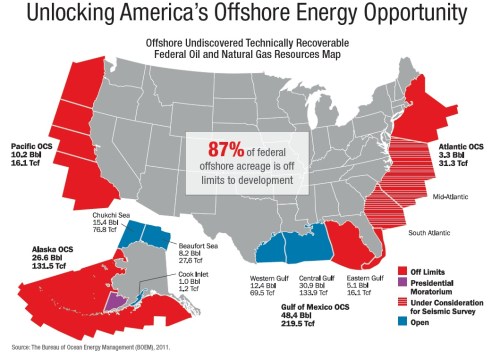
Indeed, the cartographical propaganda that was unleashed by groups as the “Institute for Energy Resources” as a “rich natural resources” blended notions of natural, marketplace, and environmental danger by disorientingly presenting the OCS as a site for further explorations that United States government crippled America’s economic power by restrictively placing “off-limits,” although the “taxpayer owned lands” contain 86 billion barrels of oil and 420 trillion cubic feet of natural gas, as if they were a god-given bounty.
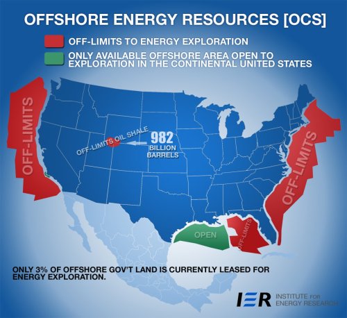 Institute for Energy Resources
There was a clear sense that even if states were able to make pronouncements regarding the accessibility of the Outer Continental Shelf, the United States government was doing so in circumstances that were decidedly not in its own control. The collective disorientation to extreme climactic variations over a year of increasingly unpredictable extreme weather–from hurricanes to fires to mud slides in the United States and western hemisphere–introduced new seasonalities oriented to hurricanes and wildfires into common parlance and to the national consciousness, as we now measure our sense of time and risk by seasons of global warming. The new seasons defined the greatest billion dollar extreme weather disasters in American history, costing in toto upwards of $306 billion— a record as if on cue with the Trump administration’s release of a Five Year Outer Continental Shelf Oil and Gas Leasing Program.
In the midst of this contesting of the OCS exploration, the arrival of the “bomb cyclone” that dramatically began 2018 with the threat to cover cities with snow, obstruct transit, pound shorelines with waves, drop temperatures, paralyze the coastline, freeze pipes, and precipitously increase snowfall, condensing climate woes. It was to maps that most turned in order to measure the arrival of cold, but it was also harder than ever to orient viewers to the scattering of snows, swirling water vapor, frozen rain and gusts of wind that spun into being and from the offshore on January 3, 2018. In part because data visualizations fail to register time, or the immediacy of its arrival, the sudden generation of a new weather system off the coastline was difficult to capture as an event that suddenly changed weather systems across the eastern seaboard, or that registered the relation of its creation–the phenomenon of bombogenesis” with a suitably biblical connotation–to the massive stoppages of traffic, power, and electricity which cascaded spatially across the seaboard, as if to suddenly suggest a new relation of land and sea suggesting that massive shifts in weather systems may be as dangerous to the nation as rising seas.

Since Hurricane Katrina, if not before, maps of environmental disasters have increasingly become emblematic not only of poor governance, but of our shared vulnerability to extreme weather. They raise the specter of such inadequacies to cope with natural disasters and extreme weather, and the decreased abilities or preparation for natural disasters. After a year of extremely costly extreme weather–the most costly year yet, in fact, as if immediate reactions to the arrival of the bomb cyclone showed not only how poorly the national infrastructure is prepared for the extreme weather that will be the norm of increased climate change, but confirmed yet again how out of step the Trump administration was with the global warming it had been busy denying, in this case with plans to open leasing for offshore drilling in the outermost territorial waters of the United States, in regions of Outer Continental Shelf (OCS) lying over three miles removed from the shores. It was with a spectacularly poor sense of timing that the Trump administration has proudly come to showcase as a new site of ensuring energy independence to the nation.
5. The confirmation of this new site of energy-exploration was waged, perpetuated and concretized in maps. Indeed, if the past eight years saw the subtraction of large swaths of the Arctic and Atlantic Oceans from prospective drilling by extractive industries to protect marine habitats, the Trump campaign decided to focus on the exploration of the Outer Continental Shelf, as if it were a new area of exploration and widely expand drilling as a means to unleash the nation’s “vast mineral wealth,” in the language of a con man and swindler, dangling the notion of “energy independence” before an uneasy electorate as if it promised an end to global entanglement, and promising working together to explore and exploit untapped offshore mineral resources that gas and oil groups have long desired. Although Ryan Zinke assures us now that local group will be consulted in this process, the eagerness with which the mapping of new “federally administered submerged lands” in the OCS seem absent from state oversight–
 Legal Boundaries of the Submerged Lands in Marine Environment (2005)
–has materialized a new region for prospecting in what is defined as the “territorial sea,” outside international conventions and three nautical miles or leagues off the coast. It may be no surprise that President Trump, the son of a landlord who has lived in a world of leasing luxury hotel rooms and was long trained in cutting the most profitable deals and sales, should open the OCS to extractive industries, while his Department of the Interior issue empty assurances of the collective benefits of leasing lands that are indeed “tax-payer owned” as if they were the basis for a massive refund on individual taxes, in the form of low energy bills.
But in an era of extreme weather, the prospects of extracting mineral resources from the newly expanded offshore regions seem increasingly and increasingly less rosy–and perhaps the very maps of weather challenges the charted the bomb cyclone and winter hurricanes become emblems not only of poor weather conditions, but the inability to govern the very areas of the “offshore” that the Trump administration has prided its ability to extract revenues, as they allow extractive industries to explore the removed continental shelf. Although the new administration has come to map the OCS as an imaginary frontier and potential source of untapped economic wealth, containing 98% of technically recoverable oil and gas lying in national lands, the very viability of that access depends on the continued denial of the actuality of global warming, and of the increased sea surges and coastal waves bound to be increasingly typical of global seas, and to redefine our own coasts and shores. For in enlisting Energy Transfer Partners and Royal Dutch Shell Plc to study sites for natural gas drilling off Louisiana, and to open five-year leases on drilling for minerals and gas off the shore, Trump’s administration has not only allowed the leasing of offshore lands in the name of “energy independence” beyond the Gulf of Mexico, but worked to end the very safety rules of offshore drilling adopted after the BP oil spill of Deepwater Horizon–dramatically increasing the chance of “deadly oil spills.”
Miyoko Sakashita, director of the oceans program at the Center for Biological Diversity, has expressed deep fears that the remove of restrictions for extractive industries who should be liable for fundamental safety systems for monitoring any equipment failures in offshore rigs leaves us open to increasingly expensive oil spills and environmental disasters. The uneasy waters of the bomb cyclone reminds us of the extent of areas that are now open for drilling along the outer “continental shelf”–a notion of “coastal waters” that really refers to the mineral seabed, previously not open to leasing–and their increased vulnerability to future storms across the oceanic expanse. If the increased area that has been proposed to be opened to drilling–even in the most sensitive of ecosystems–expose the seabed to drilling across the “submerged lands” the lie just beyond the state-owned shelf lying closer to shore, withdrawn from leasing from 2007, when they produced over a quarter of the oil in the United States, suggest a huge windfall for energy companies, who now stand to be able to place bids on offshore lands once more.
While the shuttering of bids on leasing offshore seabed lots from the federal government ended a practice from the mid-1950s of leasing submerged lands in the outer continental shelf, which lie beyond state jurisdiction, the campaign promises of Donald Trump to return to a vigorous leasing program stands to develop the outer “offshore” to tap its mineral wealth, opening the 94% of “submerged lands” closed to drilling to bids–and doing so with far less public oversight over development of areas for oil and gas exploration from state and local government, as well as the public–as well as legislators who have long opposed coastal drilling or ocean stakeholders, rehearsing the familiar argument that such lands were indeed “taxpayer owned” as a basis to “streamline” extraction of oil and gas from the seabed, without regard to underwater canyons, coral reefs, delicate ecosystems, and National Marine Sanctuaries and Monuments in the OCS from potential drilling.
Not that Trump or Zinke had mapped these lands themselves with unbearable vagueness and an apparent lack of attention to local detail: the notion that such “federal offshore” lands were defined as “off-limits to development” was a broadside launched in 2012, as the “technically recoverable federal oil and natural gas resources” were embodied by the American Petroleum Institute as a brief for future prospecting, at the same time as the elimination of $4 Billion of tax breaks for the oil industry was presented as discouraging oil exploration–advocating exploration with a very, very broad brush.
 Natural Gas Resources (trillion cubic feet) and Oil Resources (Billions of Barrels) in OCS
As we have become an increasingly and definitively less and less of a maritime nation, the effects of energy exploration on coastal America have become elided, especially by a Secretary of the Interior from the inner states–Montana, home of the former Navy SEAL and Special Ops officer–or the Heartland Trump claims to have won convincingly in the General Election, and seems t times to run as a coast-free country, in ways that may even suggest something of a crisis in political representation in relation to climate change.
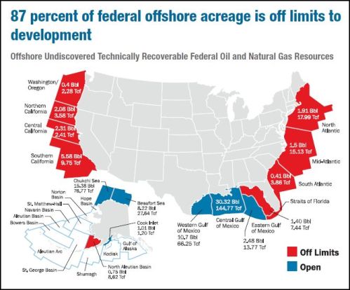
The coasts are largely less well represented, for the most part, in Trump’s cabinet. The fears of an increasingly vindictive attitude to the northeast and west may seem part of the President’s newfound attachment to an imagined “heartland.” Zincke seems to follow the eagerness with which the American Petroleum Institute has long promoted the image of “vast undiscovered oil and gas reserves” in huge tracts of land lying undersea, which they estimated contains an “untapped” 89.9 Billion Barrels of oil and 327.5 Trillion cubic feet of natural gas; plans for “unlocking offshore energy” seemed to have been realized by January 5, to considerable applause from the American Petroleum Institute for making “over 98%” of areas with technically recoverable oil open to drilling, as new “planning areas” for prospecting were unveiled that seemed poised to override National Monuments or marine sanctuaries

The remove of regions long intended to be declared part of our national territory to affirm rights of oil and gas extraction seem increasingly undone by the increasingly unruly oceanic areas we once were so quick to claim lay within our sovereign bounds. If the ability of the government to lease these lands was based on the map–and the maps of the removed continental shelf that was absorbed into the national territory in the 1940s, the manner that drilling rights have been waged on maps as it was safeguarded from exploration seemed suddenly questioned by extreme weather events–and indeed raise questions of where responsibility for disruptive events in the outer continental shelf would lie for an oceanic region we have only begun to map for future prospecting.


Yet as winds battered the shores of the Atlantic, dumping freezing sudden snows and arctic air over the region, was the colonization of the coasts with equipment of energy extraction the best idea?
6. The sudden confluence of not and cold weather extremes were predicted to “assault” the eastern third of the United States with more “severe weather,” as a “monster storm will hammer locations from Georgia to Maine” bringing thick snowfalls and precipitous drop in temperatures; as cold air was sucked in from the arctic, a drop in air pressure set of winds that sent record high tides to ram the coast as windstorms snarled holiday traffic across the east coast and rattled nerves–even if it also may have provided yet another instance of extreme weather.
The bomb cyclone “ignited” by the colliding meander of the warmer waters of the Gulf Stream with cold air, creating a dramatic drop in pressure in Atlantic waters, was itself the latest evidence of the dangerous effects weather extremes. In a sense, coming from California and with fires very much on my mind–in specific, the mapping of fires’ spread in Southern California and in the North Bay, whose parched landscapes have helped define a new landscape of combustibility fanned by increased Santa Ana and Diablo winds–the visualizations that sought to provide some orientation on an imbalanced climate was already a focus of attention.
But with particular poignancy, the maps of the sudden air pressure drop seemed to concretely render the actual absence of any center of American leadership on climate policy or climate change, as the steady generation of visualizations of climate imbalances sought to offer some grasp on our increasingly volatile weather combining extreme aridity and intense precipitation, and characterized by warming air temperatures and freezing rain, spinning wildly out of control and sending snows, high winds, breaking waves, and arctic temperatures across the entire eastern seaboard without warning. In an era of forecasts, the bomb cyclone suggested just how much the prediction of extreme weather was becoming impossible: long after the hurricane season’s end, the arrival of a winter hurricane raised a curtain on the dangers of such extreme climactic variability.
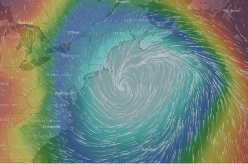 WindyTV.com
The bomb cyclone resulted from the confluence of the warm Gulf Stream and arctic air provides more evidence of increasing climactic instability, high winds, and sea surges across the oceans of an increasingly warm world of weather extremes. While we were assaulted by visualizations of “observed” snowfall analyses when the northeast already faced blizzard warnings and storm watches extended along the entire coast, the human aspect of its creation–or its impact–was increasingly removed for viewers of images on television news, who watched a winter cyclone at the end of the hurricane season, and bringing a foot of snow to much of the east coast, as if metaphorically bury any human presence beneath it, as if to hope they might crawl their way out, like the alligators frozen in North Carolina ponds who stuck out the frost.
The meteorological violence provoked by such a sudden fall of air pressure off of New England has unleashed winds as strong as Hurricane Sandy, and lower temperatures than on Mars, sets yet a new standard for the explosion of climatological assaults. Rather than the southern Gulf Coast, or the west coast fires, or the aridity of the great plains, the climate’s coherence was undone along the eastern seaboard, as a coastline already battered by storms, as a kink in the warm gulf stream met an influx of arctic air. And for one morning, the influx of cyclonic streams of frozen precipitation snowed in the coast, for a few days making the eastern United States and Canada the coldest places on earth–and the sites of the greatest temperature anomalies.

7. Viewers struggled with the cognitive problem of integrating human experience or presence in the color pallets of the rich data visualizations of the arrival of colder temperatures–and indeed of moving from the global–or regional and continental. Reading the local effects of the huge drop of temperatures and arrival of arctic air after the sudden drop in barometric pressure posed difficulties of coming to terms with the local effects of the pressure of such a regional onslaught of snow local populations–or of putting human inhabitants into the space of the weather map. The problems were reflected, perhaps, in the soundbite of the day that temperatures were colder in Maine than on Mars, or that with windchill, parts of the White Mountains were a full 100°F below zero: the spread of subzero temperatures at a remove from their impact on humans–save, perhaps, in 4,000 cancelled flights on the east coast, a rise in proliferation of traffic accidents and downed electric wires that made heating failures widespread. The plight of the homeless were minimized and most stories punted on their relation to global warming or the burning question of climate change.
Perhaps the arrival of the snow and tremendous drop in local temperatures as a result of the bomb cyclone was just too overwhelming to process as we were faced by snows and sudden drops in temperature, and just wanted to measure their extremity, stunned tat the sudden prospect that this was just the new normal. How to process the plunging of temperatures save with some bizarre sense of irony? The arrival of bomb cyclone was most oddly paired with the sudden announcement of the plans for the expansion of permits for offshore drilling that the government had so opportunely decided to announce at the same time, with a sense of timing that created a bizarre juxtaposition on news feeds. While we are used to tracking hurricanes arrival, or were used to NOAA mapping them in the recently concluded hurricane season that so devastated Puerto Rico, the Gulf Coast, and parts of coastal Florida, the sudden appearance of the pressure-shifing “bomb” suggests the climate is turning against itself without a few hours of prediction window, creating a ” bombogenesis” of a sudden free-fall drop of barometric pressure, disrupting not only the seas, unleashing of blinding snows unheard of save in the High Plains of the Old West, when the fall of snowflakes occurs with such a density to disorient all without shelter, in ways that seem a plague on the populations of homeless and most vulnerable.
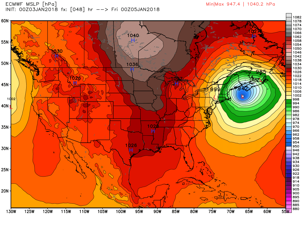
The sudden drop in temperature, which meteorologists quantify as exceeding twenty-four millibars in just 24 hours, seemed to immersed much of the globe in a weird unearthly gale akin shimmering rain, suspended in odd patterns over the earth rather than directly falling to the ground, uncorking of hurricane-force winds with gusts of fifty miles an hour and higher brings a sudden smothering that warps space itself. But it must be put in context. The cyclone bomb was an intensely immediate manifestation which occurred to fourteen of the previous 20 hurricane-force wind events in the North Atlantic in the winter of 2014, as wind speeds accelerated beyond historical averages. The eruptions, which occur as cold air masses move over warming waters, and collides with the warm air above a warming ocean, are evident in the higher windspeeds over the warming Atlantic, and while perceived as an acceleration of freezing winds, with disastrous cascading effects of snowfall, arise from our ever-warming seas, by which they are generated–much as the hurricanes over the warming Gulf of Mexico that hit its coast–and of which they are the consequence.
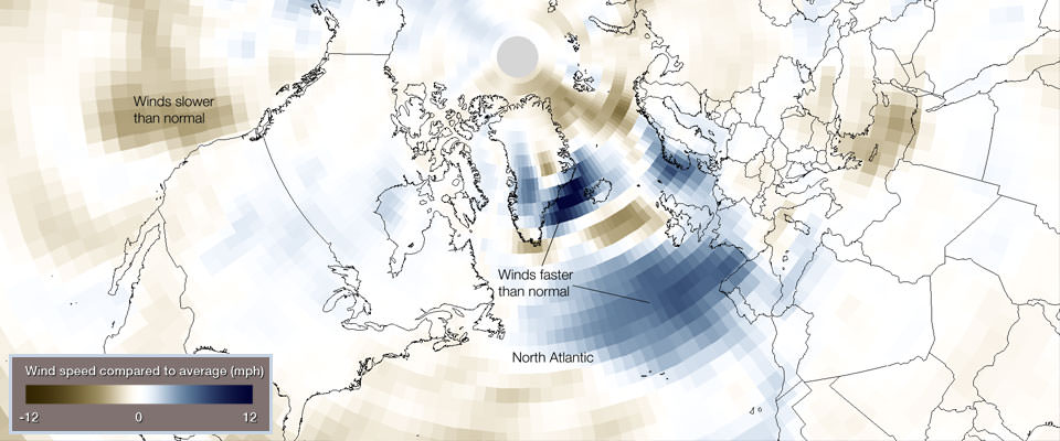 NOAA/Environmental Visualization Laboratory
The sudden warping of climatological space takes its spin from the shifting contours of cold and warm air, creating a specific” density” of hurricanes and cyclonic winds that have rarely–if ever been–observed before. In ways that suggest the specific appeal of climate change to the End of Times crowd, bands of deep blues in the visualization above that collapses thirty years mark areas where winds have accelerated to levels above the historical 1981-2010 averages, much as the lower than usual wind speeds over the Pacific Ocean in the same period have helped produce far more dry lands in the western states, than usual, increasing their combustibility to new heights, to the extent that flames are ready to be fanned by the high, hot winds over the central plains. If such models began to be measured to ensure the safer navigation of waters, by NOAA, in an increasingly heavy area of navigational traffic and shipping, the sudden occurrence of twenty hurricane-force events measured between just January and February of 2014 set a record of something like a time-bomb for the increased acceleration of winds today from early morning. Howling winds awoke most east coasters, followed by the noisy grating of clunky snow plows pressed into service to clear accumulated heaps of snow.

Another means of visualizing the increasing transformation of hurricane winds to such episodes of bombogenesis, or immediate pressure drops, must start from the increased anomalies in sea surface temperatures of waters themselves, as sensed with accuracy from satellite measurements of stations of earth observation–remote observational stations of the very sort that the Trump administration sees fit to curtail–which suggest the effects of a growing arctic oscillation sending cool air south from the upper north, cooler waters released from melting ice and polar caps, and rising sea surface temperature in the Gulf of Mexico, central Atlantic, off eastern seaboard of the United States, over the same thirty year period of 1981-2010. If weather anomalies became more apparent for the first time in that period, the changes analyzed in the fall of 2017–just before the election–revealed a troubling record of disparities in sea surface temperatures created something of a schizophrenic palette of sea-surface temperatures–

NOAA
–based over a thirty-year period in relation to earlier temperature norms, which was only posed to increase in extremes in the most recent prediction of rising temperatures in sea surfaces worldwide for 2017-18, where the cyclones rise due to increased sea-surface temperatures by two degrees C since 1990, seems only poised to increase the juxtaposition or enjambment of cold and warm waters, and warm waters and cold air.
 JAMSTEC mid-October forecast of sea surface temperature anomalies for 2017-18 winter season (December/January/February). The boxed region shows La Nina conditions (colder-than-normal, blue) in the equatorial Pacific Ocean and the circled region shows a mixed bag in the northern Pacific. (forecast map courtesy Japan Agency for Marine-Earth Science and Technology)
It seems significant that we are hear these predictions from Japan–a nation far more rooted in nautical traffic, fishing patterns, warming waters, and sea-level change. It seems almost as if our own remote sensing data has failed us. But it is also evidence of how weather maps have come to illustrate a sense of our unpreparedness and poor governance, and increasingly makes the once neutral tools used to map weather a pointed image of political critique of ungovernability, as much as only as tracking water patterns for convenience or easy consultation on maps. The increasingly powerful content of weather maps as a barometer of political governance–and of mapping social preparedness, as well as personal safety–suggests the extent to which we are all more and more ready to admit our vulnerability to climate change, and the inadequacy of a continued official denial of its existence.
But the problem of mapping the raging winds of the offshore “bomb” whose howling will be heard across the coast, in a climactic culmination of a week of cold days that will dump snow across the easter coast, was felt in perhaps correct ways as an attack on the usually solid weather systems of our nation, and as if the weather systems of the world were now able to be framed as a clear national threat. While its eye was solidly located over the sea, but stream blizzards and gale-force winds across the entire coastal region and far inland, paralyzing motion and reminding us again, as we watch maps indoors on screens, of how interrelated extreme weather conditions are, and help force us to get our minds around the complexity of the cascading effects of climate change. If isolating the wind currents that will be most out of the ordinary seems the primary challenge of needed maps–since it is so hard to measure or render those howling winds, blowing at near horizontal angles across urban canyons, paralyzing traffic and causing authorities to urge inhabitants to remain indoors until it passed.
 WindyTV.com
Plunging pressure systems helped unleash cyclonic force blizzard winds expected to scatter snow across the seaboard. The metaphorical purchase that smart bombs, dirty bombs, and terrorist bombs have gained since 9/11 are perhaps displaced to a purely climatological register since they serve to suggest how the once-civil nature of weather systems are out of whack in their increasing extremity, and destined to spread deeply disruptive weather systems according to the most accurate forecasts or predictions.
The falling of pressure systems in an eye of a hurricane seem foretold most directly off of the New Jersey shore in a simple rainbow by Ryan Maue, as plunging the pressure system in a steep inequality that is the dominant interpretive frame of reference for the sudden uncorking of winds that arrived Thursday morning in the early hours, speeding down streets with an eerily uneven whistle to wake sleeping residents, foretelling the gale-force winds that lured snow in dense clouds at sharp angles in the hours to come that would be followed by the patient gutteral growling of snow plows.

The plunging of the pressure systems seem to overlay with the area of future drilling. The convergence of water vapor and pressure systems transcend the jurisdictional lines that lie beneath them, and appear increasingly flimsy bounds. U.S. National Weather Services responded through cautionary storm watches and warnings for the eastern seaboard, the coast destined to be broadly buffeted by freezing winds that will create “difficult travel conditions” up and down the seaboard, for those still preparing to drive from Disneyland to most any place on the eastern coast. The streams of vapor, far more resembling the cloud-streamed skies of a Star Wars desert planet Tatooine than anything we might recognize or meteorologists have oriente us; swirls of water vapor spun off the rising winds, bringing temperatures that are indeed colder than Mars. If all maps require scale bars, the water vapor flows that swirl off of the eastern seaboard suggest a new notion of contour maps, where the contours of weather trump the shape of the land.

We now track storms not by linear paths or trajectories, but against bar charts that suggest scales of intensity, to measure the spread of snow along the coast. The sudden blanketing of the eastern seaboard reminds us of the increasing currency we are bound to see of a new sort of contour map, tracing a shifting topography of increased weather extremes that drop moisture in huge concentrations, that demand the better integration of bars, graphs, and overlays that can better allow us to read the increasing irregularity of the uneven concentrations of snow, sea-surface temperatures, across a region we once believed continuous.

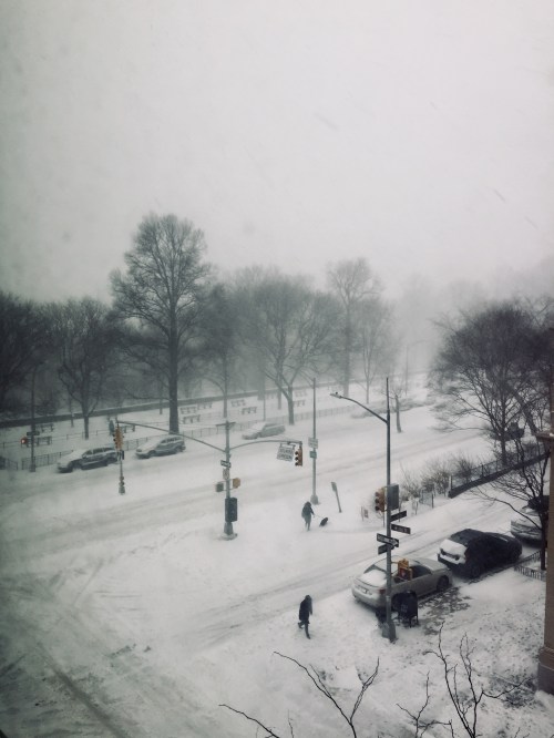
8. The narratives of the bomb cyclone immediately demanded to be given local meaning. The arrival of tempestuous winds created a sudden wailing in the streets before dawn in New York City. The wailing winds must have woke many, as they did me, who suddenly saw the onrush of dense streams of snow entering the city at full speed, dumped across streets and filling urban canyons. At the same time as storm surges threatened shores from Maine and Massachusetts to South Carolina, streets were flooded by icy water in Boston and New Jersey. The surges of waves threatened the not only the stability of the shores but paralyzed traffic and inhabitants, as traffic accidents multiplied like wildfire along much of the east coast–evident in weird maps of accidents along the shore. As engines froze on highways, cars veered off to the side of the road, and a sense of time stopped as some 4,000 flights were canceled and the infrastructure seemed to pause temporarily: airport equipment suddenly frozen or unable to be used, airports turned into crowded hubs of panic, traffic was snarled, and lone delivery bicyclists navigated the streets only after they were cleared by clanky snow-plows. The air was so thick with snow that visibility declined as if one was hunting bison in the high plaines of the old west.
From indoors, we wondered how to relate the local experience to the unforeseen arrival of howling winds and driving snow. This is perhaps the most alarming question of watching the rapidly shifting weather maps, nestled in our increasingly geographically reflexive internet bubbles. Gazing at images of our snow-covered streets, one could only imagine the thick snowy blankets that covered much of the east coast, but we were surrounded by a local disaster as if it was unrelated to the hurricane season which had officially ended, or the consequences and after-effects of hurricanes, floods, and weather disasters.

As the skies cleared of sheets of snow, by the next day, the arrival of more arctic air meant temperatures continued to drop in the unwinding, crisp dry air pulled in by winds speedily rotating counter-clockwise from the northwest and plunging temperatures across New England, creating incredibly crisp skies as precipitation ended above a frozen landscape that scarily seemed both oddly arid, uninhabited and uninhabitable.

It was more than an eery coincidence to the ruffling of ocean waters, in terrifically poor timing, the Trump Department of the Interior (DOI) took the same weekend to announce its intent to lift all bans on offshore drilling on a continental shelf, opening 90% of federal offshore land known to contain oil or gas to drilling. To be sure, it was back in the sunny Spring that so-called President Trump ordered Ryan Zinke to consider expanding offshore drilling, and removed a ban on arctic drilling. Zinke’s uncanny decision to take the New Year as a time to announce the DOI’s intent to auction off sites in the shelf from 2019 to 2024 in all but one sector of the Offshore Continental Shelf immediately raised specters, not only of an expansion of “a radical drilling free-for-all” as per the director of Oceana, but a case of poor judgment of attempting to “turn our oceans into drilling fields,” as Kristen Monsell of the Center for Biological Diversity put it; the specters that were conjured of overturned rigs in turbulent oceans, spewing huge volumes of oil that would provoke a massive die-off of unprecedented extent.
The increased danger of spills from violent weather and surging seas driven by high winds may not be the major fear, but the oceanic unrest suggested the difficulty of potentially working to plug any future leak during extreme weather conditions: much as the frozen luggage conveyor belts after dropping temperatures as the bomb cyclone grew in the northern Atlantic prevented passengers in transit from receiving their luggage, and downed electrical wiring and interrupted gas mains, the context of environmental disruptiveness raises questions of the readiness for underwater drilling tools for an era of increased climactic turbulence–especially as many of the safeguards put in place for rigs after the Deepwater Horizon fiasco have been removed.
9. The spectacularly ill-timed piece of theater, by lifting existing bans on offshore drilling formal in the Atlantic and Arctic and indeed inviting their leasing for energy exploration. As snow floes filled piled high with snow started to run down the Hudson, and a sparkly blue sky arced above a frozen landscape, one couldn’t but wonder about the coincidence of the turbulent weather “bomb” and the disruptive wind explosion that whipped weather over the open seas that seems increasingly the norm as the warming Gulf Stream that long warmed the Atlantic intersects with colder air, flooding the federal agency known as the Bureau of Ocean Management with over half a million comments protesting the decision to allow extractive industries to set about running seismic tests to locate new sites for lucrative offshore drilling.
Perhaps the maps that show the range of the Outer Continental Shelf, newly opened for drilling, perpetuates a failure to consider the deep risks that the expansion of drilling poses to the oceanic spaces that are flattened in most maps of the areas in which drilling sites have been proposed to be auctioned off by the Department of the Interior–as if the OCS were the “interior” of the nation, by an odd cartographical fiction and conceit. For if the notion of an “outer continental shelf” or “extended continental shelf” was a conceit to expand national territory of the 1979s, allowing unilateral declaration of the control over mineral resources lodged in underwater lands that redefined territorial limits through new mapping tools, the increased turbulence of such winter hurricanes throw quite a serious wrench in the governance of such offshore lands that were charted and claimed as territory during the 1970s. The expansion of claims to offshore rights served to stake claims to gas and oil from the 1940s in ways that enlarged the notion of “territorial waters” in terms of speculation for exclusive mineral rights, far beyond earlier acknowledgement of fishing rights, the expansion of exclusive claims to underwater regions in an extended continental shelf reflected new abilities to map lands underwater not only in relation to distance from the shore, but the shape of the seafloor and sediment thickness, increasingly allowed by the extra-national conventions and authorities in a new “law of the seas,” in response to United States claims.
Indeed, the new logic of “territorial” claims in the Outer Continental Shelf (OCS) suggest the unwanted confidence of the Trump Administration to be able to promise the tranquil governance and calm of the very offshore areas where it seeks to lease drilling rights.
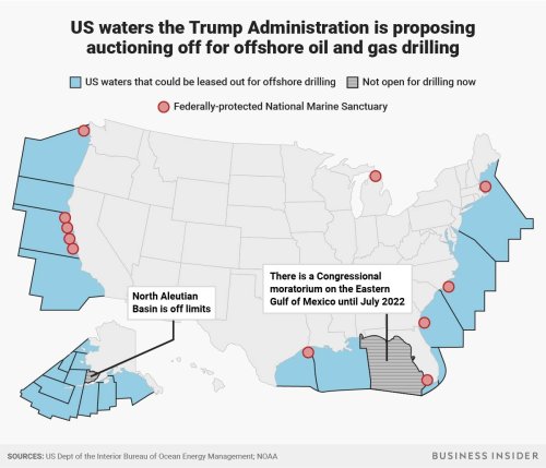
To be sure, the opening of the offshore regions of the OCS contrast to the sharp limitations imposed in the Obama presidency for what areas might be explored, with the result of closing some 94% of OCS territories.
The amazing absence of attention to the ocean save as a surface conceals the very topography of submerged lands, or their depth, or the dangers of drilling, only a decade after the Deepwater Horizon disaster. Indeed, the current administration has moreover proposed to undo the very safety preventions that were put into place after a piece of faulty machinery caused the spill, raising the specter of a multiplication of future spills, even despite the Congressionally imposed moratorium that currently exists on drilling in the Eastern Gulf of Mexico. The expansion of new ‘frontier exploration’ of the OCS has pushed into a new spatial imaginary, or rather resurrected or recycled early hopes for energy exploration Of the other 26 mapped “planning areas” of the OCS, some twenty-five were announced as open for drilling by executive order–the area of the Eastern Gulf of Mexico long off limits–as if to map a new frontier of the analysis of offshore areas of exploration. In what seems yet another instance of the dangers of running the country as a business, or of treating the nation as a landlord–rather than as a guarantor providing for the public good–the Trump administration has bequeathed a gift on allies in the energy industry, rescinding a direction that began with EPA recommendations in the late 1986 to stop the leasing of submerged lands in the North Atlantic, Southern, Central and Northern California, Washington-Oregon, and the Alaskan Aleutian basin.
The lifting of the moratorium was long in the works, and long cast as another means to liberate the country from the imposition of restrictions on accessing submerged gas and oil–as failures of heating oil and gas mains due to the extreme weather reminded us of their need, but also how very far away the deposits lay on the ocean floor. The Interior Secretary purveyed the deception that they were just waiting to be tapped, and easily mapped. Any moratorium on drilling was presented as posing an impediment that “deprive[d] our country of . . . thousands and thousands of jobs and billions of dollars in wealth,” as if to confirm that previous administrations just didn’t have the interests of the United States at stake at all. The announcement waged an irresponsibly deceptive shell game distracting attention from increasingly restless seas–using the fiction of our “territorial waters” to describe lands now being “made available” to industries, defining them in absurd terms as “taxpayer-owned” if outside the state’s “submerged land boundaries,” linking them to the territory of the nation in ways that may raise eyebrows of most of its citizens. The mapping of the Outer Continental Shelf as a new region for speculation conjures images of a new Virgin Land offshore, ready for leasing for drilling projects, or prospective exploration for drilling and leasing.
If the materialization of the offshore that stands poised to make the government the greatest landlord of the offshore, the heightened turbulence across the Atlantic seems to militate against the very project of considering to lease sites for drilling in the open seas. To be sure, the project of managing mineral resources on the OCS has been longstanding. OCS development was widely discussed in 2004, both for “nourishing” beaches with sand deposits and wetlands restoration, although the benefits of dragging sands into the shore has been broadly disputed, and the planning of oil and gas resources in what was almost a third of the nation’s oil production and a fifth of its natural gas production with almost 8,000 leases across 42 million acres back in 2003–
Sanctuaries (pink), leasing areas (blue) and areas withdrawn from leasing (yellow) in OCS
–which was curtailed only with growing concerns over their environmental impact.
10. We might forget that the territoriality of the Outer Continental Shelf was created on maps in relatively recent years, allowing the possibility of leasing offshore land. Indeed, maps of the OCS allowed it to be presented as an edifice for the new dogma of energy independence, as if it were without risk, and as if lifting environmental safeguards was fundamentally a good–although calling it administration of a public good.
The cyclone bomb’s arrival revealed the dangers of the vacuum of environmental policy in Washington, D.C., if not pthe sinkhole climate leadership had become since leaving the Paris Accords, and disdaining the actuality of global warming. Twitter famously provided the medium and created the audience to spin the fake news of deniying the threat of global warming–“We’re going to put America first. That includes canceling billions in climate change spending for the United Nations.” (Trump paired his yearning days previous to the bomb cyclone for a bit of “that good old Global Warming” with some irony as a sham “our Country, but not other countries, was going to pay TRILLIONS OF DOLLARS to protect against,” but his administration had saved taxpayers.) Such obsessive presentation of climate change as a source of undue imposition of costs concealed the still deper coasts of ignoring climate change and the extreme weather it stood to generate; as much as filling to distinguish day-to-day frames of weather and the broad scale of climate change, climate change was cast as a monetary burden, and leasing he OCS for energy speculation myopically presented as an economic benefit, without regard for how winter hurricanes, disruptive tides, and surging seas presented obstacles for the expansion of access into this new submerged frontier.
And cold weather that was being faced by the United States in late December as New Years approached in Eirie, PA–
 Credit@theworldaroundnikki on Instagram, via Reuter
–coexisted besidd the increasingly warming nature of the rest of the world, although a far colder than usual late December spell was evident across most of the United States:
The dangerously myopic nature with which the Department of Interior has pushed for expanding permits for energy exploration in the OCS has been presented as a victory for the economy and for energy independence. But can we continue to push for energy independence while denying the increasing dangers of local effects of climate change? The recent decision, post-Sandy, of the New York City Mayor to remove funds for pensions from energy companies, and indeed to bring suit against those energy companies involved in energy industries for the costs of global warming, even as multiple states–Florida; California; New York; New Jersey; South Carolina–seek exemptions from offshore exploration, or the local instance of global weather change.
The fiction of mapping the Outer Continental Shelf suggests peculiar blinders to global change, by reifying an area of offshore energy exploration as a part of national territory. Mapping territorial waters as part of the area over which the government administered–and indeed part of a national territory–was a relatively recent creation, as the treatment of submerged lands as an increasingly visible part of the national economy. The conceit of the proximity of these waters, and the accessibility of the Outer Continental Shelf, was punctured by the arrival of high-velocity winds and frozen precipitation. For while Zinke, Trump & Pruitt purveyed the conceit energy independence could be promoted independently of climate change, the extent of disturbances to the sea surface equilibria, surging waters, and violent cyclonic storms may have made some wonder. At least five states–California, Oregon, and Washington, with Virginia and Florida–have tried to push back on this project of deregulation, limiting the needed onshore activities to support any offshore rigs, plans to open lands in the Outer Continental Shelf to five-year leasing for energy speculation including in nine plots in the Atlantic, twelve in the Gulf of Mexico, seven in the Pacific ocean and nineteen in Arctic waters off Alaska stands to introduce a new land-grab free-for-all in lands that have been symbolically annexed to the United States by maps that remains outside the jurisdiction and sovereign claims of individual states–bounding a Brave New World whose bounties are to be administered by the Secretary of the Interior and Ryan Zinke, who seeks to remap those waters as factotum of the energy lobby and American Petroleum Institute.
The region only mapped as part of the nation unilaterally on August 7, 1953–at the height of the use of new mapping systems that were the outgrowth of the Cold War, as the DOD pumped increased money into the mapping and asserting of territorial claims, the useful cartographical fiction that presented the OCS extending three miles off the coast out to the sea, claims to state sovereignty of submerged lands stand to be treated as a form of fungible real estate administered by the Bureau of Ocean Energy Management–a sequence of “extra-state” lands open to speculation and leasing under a mandate of “energy independence,” based on the new spaces that radio telemetry allowed the government to map in the Outer Continental Shelf Lands from 1978, when the system of federal leasing of offshore areas, in response to fears of another energy crisis, was allowed from the Bureau of Ocean Energy Management. While radio telemetry had allowed cold warriors of the Eisenhower administration to define the OCS, in a radio spatiality, GPS maps permit the Department of the Interior to lease specific sites on the open seas by staking claims to lease “rights” to specific submerged lands, in the expansive radio spaces Shoran and Loran systems helped create since the 1960s–just before the environmental movement–by opening sites of prospecting to precise geodetic measurement. William Rankin argued in a recent study of the powerful role mapping systems play in reshaping territoriality, “featureless oceans become legible as the intersection of two city streets.” Advertisements that appeared by 1959 in magazines like Surveying and Mapping by 1959, created a spatiality of the ocean floor that provided precise geodetic maps of submerged lands; while such advertisements were intended to map a ship’s position, the logic of such spatialities underlie the leasing of OCS lands.
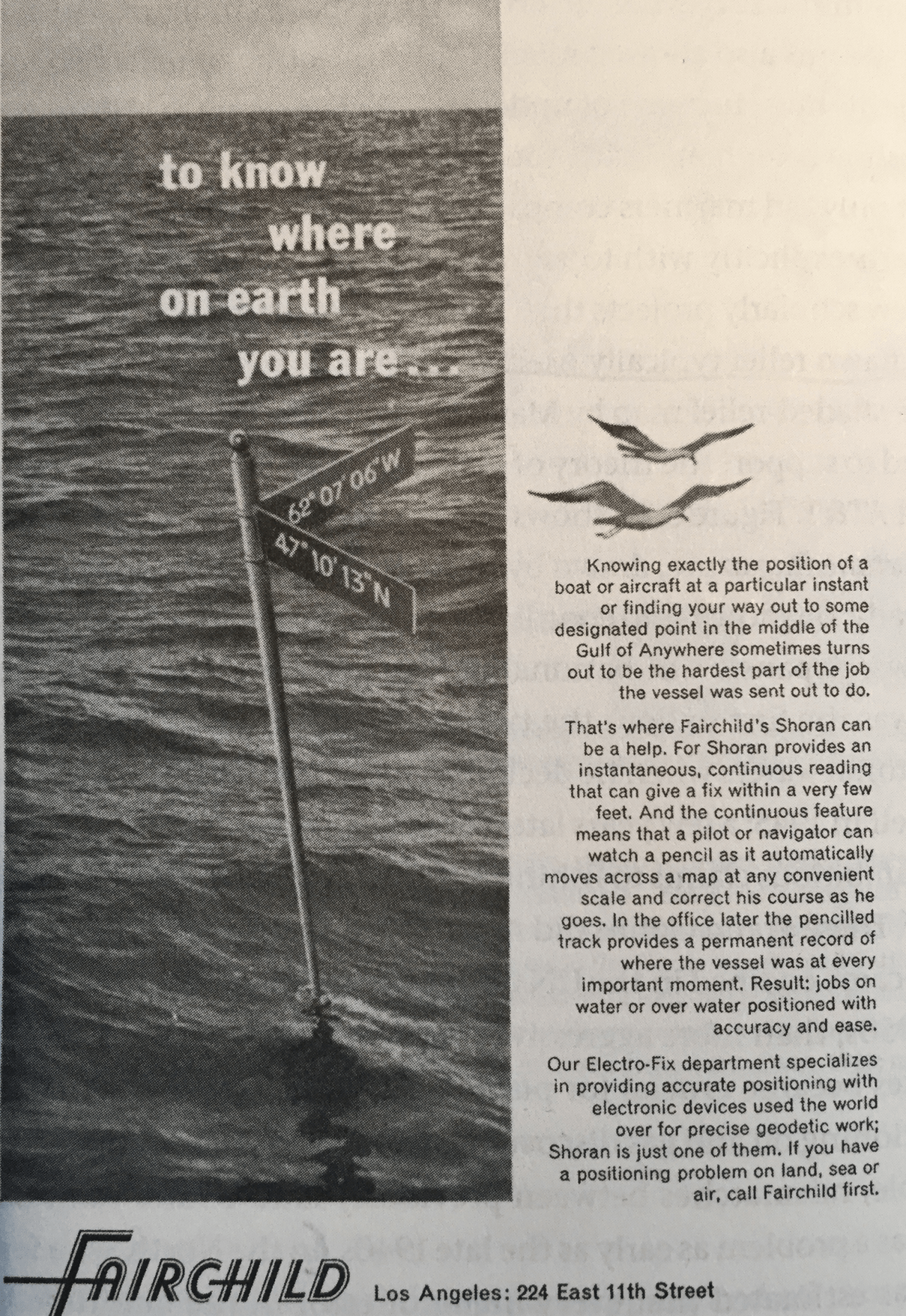
Surveying and Mapping 19 (March 1959): 141, from Rankin, After the Map (2016): 236
We were suddenly reminded that the Outer Continental Shelf was part of the nation, as it was cast as a separate province subject federal control in a range of new maps of the OCS that foregrounded the “submerged lands” now open for mineral prospecting. The huge expanse of underwater submerged lands were presented as if they were new sources of abundant wealth and of untold energy resources waiting to be tapped. Multiple state governors have threatened to create what may be serious obstacles for leasing ocean plots by locally withholding needed permits for launching equipment and offering rigs onshore support, or affirming state jurisdictions of the first three miles offshore.
The specter of such territorial tensions between federal and state governments suggested a very dangerous tug of war all to characteristic of our political union, such as it is, and of the paralyzing dangers of a lack of collective consensus in the face of climate change. One fears that the premium that the federal government placed on making such watery spaces “open for business” will provide considerable pressure to states not wanting to be seen as against jobs. If some states may able to deny onshore equipment from coastlines and necessary permits, the powerful if deceitful platform for energy independence may be difficult for most to resist in areas in the Mid Atlantic, and is openly advocated by state officials in Alaska, Louisiana, and Texas: the expansion of areas of unrestricted on oil and gas drilling would of course make leaks far more difficult to limit or control.
11. The anodyne nature of the names of these new regions is disturbing as familiarity risks removing dangers for proposed projects of oil and gas leasing that the Department of the Interior. DThe spatiality of radio and marine boundaries set by satellites are unknown to most, for the time being, but effectively masquerade as regional territories with some familiarity on the map–with generic names as “Mid-Atlantic,” “North Atlantic,” “Central Gulf of Mexico,” “Straits of Florida,’ “Southern California,” “Central California,” “Washington/Oregon”–giving them a familiarity as places conceals their place in the Brave New World of oil prospecting, where extractive industries will rent about a fifth of the newly mapped United States, including sites of future bomb cyclones and surging seas that stand to create environmental disasters impossible to plug.
 Proposed Outer Continental Shelf Oil and Gas Leasing for 2019-2024 in Lower Forty Eight (Bureau of Ocean Energy Management, U.S. Department of Interior)

The new spaces of accurate position management through shore stations–as was advertised in 1971–ramped up to satellite determination of sites for placing drilling rigs in current mapping tools–affords the needed tools to construct leased spaces for prospecting, without needing shore stations by a similar sets of alternate coordinates, in the new radio spatiality of the underwater submerged lands within the OCS. As Rankin puts it, in new radio spatialities, “the surface of the sea [is] made solid and ready for inscription” by a new sort of surveying, allowing the staking of specific claims to leased land were recorded and marked from the 1970s with new precision; the credibility of leasing acres for drilling occurred despite the remove of the mineral deposits on the ocean floor from the surface of the map, by maps that promised immediate low-risk access to hidden wealth. Maps of leased claims in the ocean floor suggest a similar sort of direct access to mineral deposits, removing any sense of the risks of their extraction, and proposing the ease of access to oil and gas deposits lying within submerged lands–and erasing or eliding the oceanic ecosystem by showing the spots for explortion and drilling as if they lay unproblematically on the oceanic surface.
 Navigation 18 (Fall, 1971), inside cover; from Rankin, After the Map (2016), 237
The newly mapped United States, which include the very sites of cyclone bombs, would inflict not only creating surging seas on areas of coastal habitation, but uncork oil rigs and creating petroleum floods to create dystopian scenarios worthy of William Gibson’s “Jackpot” or Octavia Butler’s near-future dystopia. Although the relation of such leased submerged lands–or “waters”–to the federally protected Marine Sanctuaries is unclear–
The newly named regions on the map offer grounds for their fungibility as sites for autocratic administration that exist “outside” the polity as we know it, but are able to be mapped as subject to direct oversight of the Bureau of Ocean Energy Management and the lobbying cronies of the Department of the Interior–even if their relation to the Interior would have been unknown to and raised eyebrows for Teddy Roosevelt. Their mapping of regions outside state supervision helped immediately provoke quite concrete images of the apocalyptic scenarios of dystopia of overturned rigs and plumes of oil spreading due to severe wind conditions create a dystopia still waiting to be written.
12. The fiction of proximity of these undersea lands with the mainland and in United States territory was a conceit plotted and perpetuated on a map. The map of areas managed for a generation by the Interior’s Mineral Management Agency who supervise such submerged lands provided a useful way to stake territorial claims to resources lying seaward beneath navigational waters as “offshore lands”–even though they lie outside the boundaries of the fifty states, but form an “Outer Continental Shelf” of submerged lands lying outside navigable waters and subordinate to federal authority. The federal government are alone able to determine exploration rights of this liminal marine zone,–which makes the US government and DOI something of the largest landlord of offshore drilling.
The image is meaningful to the eyes of Ryan Zinke, formerly of the Continental Divide, and, no doubt, Donald Trump, keen to lease them at the fictional “fair market value” of minerals extracted from public lands, with limited oversight of the specific marine ecosystems in which they are situated, as if to transform them in the manner of a new Virgin West, to use an old geographic conceit whose symbolic status Secretary Zinke’s declaration quite sneakily evoked.

There has been some recent latitude in defining the space and administration of the near offshore. Opening of drilling rights were announced as liberating industry, as if opening the Outer Continental Shelf to drilling was analogous to opening the lands to liberating territorial waters, irrespective of the growing risks of drilling on our continental shelf in unstable seas. Yet as we processed the first visualization of the increased restlessness and unpredictability of weather systems due to shifting sea-surface temperatures, the very conceit of the stability of such offshore regions seemed an increasingly bad idea.
Even if environmental concerns have been swept under the table, indeed, with the determination to update the conceit of “energy independence,” rehabilitating a conceit of a Reagan vintage with a Bush II-era conceit of the Homeland and its defense, the dangers a changing climate poses to offshore expansion of drilling throws a spanner into the plans for oil prospecting that its engineers all too conveniently deny. Although now we could easily see where sites of speculation ay on the map, and were indeed prompted to imagine open regions ready for exploration, which are mapped as lying within sovereignty, the abstraction of the map only serves to remove them from any impact on marine ecology or environmental risks. Indeed, although the doubling of the “offshore zone” administered by the United States government during the Clinton administration increased the presence of Coast Guard enforcement to curtail the pollution foreign ships caused in territorial waters back in 1999, and place ”would-be smugglers and polluters on notice that we will do everything in our power to protect our waters and our shores,” the new assertion of ownership of “our waters” is premised on facilitating leases for oil and gas speculation from American companies that endanger the ocean waters by multiplying potential risks of oil spills and environmental pollution, as if in an attempt to erase the memory of plugging the leak of Deepwater Horizon disaster, and assurances of improved rigs. But it seemed evident that the nature of extreme weather events of the sort witnessed lay outside of those foreseen by their designers.
The notion of such impact seems almost implicit in the metaphoric conceit of the cyclone bomb. The notion of a Homeland provoked an obsessive faux existentialist concern with hidden bombs in our boundaries, and the cyclone bomb uncorking violent winds summon the huge damages that may result from the intersection of the increasing meander of warm gulf stream with cold air, provoking a sudden pressure drop drawing increased moisture from the air, and spinning condensed precipitation over much of the northeast; it aptly suggested the explosive nature of instability across waters adjacent to the Outer Continental Shelf, even if those dangers are may be quite conveniently masked and concealed by most of the current BOEM projections of leased submerged lands.
NOAA GOES
The melding of an inadvertently strong climatological rhetoric, attempting to encompass the emergence of weather extremes and designed to describe the suddenness of cyclonic formations drawing, intersected with the bombast of the President to create cognitive dissonance for the nation, and a body politic that seems already in a state of some shock. As if the biggest bomb has arrived in time for the New Year, the cyclone bomb, and it was spun into the Homeland by our own warming seas. Plunging temperatures and rising winds will surely shift attention temporarily from dreary debates of global consequence about who has a bigger button, or forcing us to try to contemplate the playing out of a test to see whose button works, the cold bomb poised to drop off the shores with a drop of air pressure sent news teams and photographers spread along the eastern coast, to capture the latest terrorist activity of climate change. The arrival brings a suitably existential chill to whoever was spending the last few years immersed in social media, forcing one to confront the gales that stand to arrive deep into the interior of the east coast, and placing the entire coast on warning from Wednesday. Can one imagine the sort of watches, warnings and advisories that stand to be offered by the government in future years, as the Trump Administration has spun NOAA’s mapping functions out of the federal government?
 NOAA/January 3, 2018
Perhaps the very problems of the mapping of unstable weather systems remains the lack of any clear narrative that can be imposed on them–they disrupt narratives, after all–and the inability to place humans in the sort of data visualizations we are given of them.
13. The unregulated explosion of cyclonic weather systems scattered snow across the seaboard like a new dirty bomb of climate change, no doubt reflecting meteorologists’ search for expression of extreme weather conditions that lie outside of the ordinary, and outside earlier standards of measurements. The urgency of the tone is not only intended to encourage preparedness, but may help to jar the country into escaping its denial of climate change but to do their job of accurate assessment, as the cyclone bomb dropped as major bombshells on the alarmingly improvised nature of Trump’s “Presidency.” While the arrival of extreme weather has provided something of a strong metaphorical condensation of questions of leadership in recent decades, from the arrival of Hurricane Katrina to the Deepwater Horizon implosion, we continue to court environmental disaster in a form of quixotic brinksmanship, not mapping the cascading impact of driving winds across ocean surfaces driven by increased sea surface temperatures and a confluence of hot and cold air that created immediately created high winds. But the weather system here seemed a scattering of reality across the seaboard, oddly cast in rainbow colors to suggest the falling temperatures it would unleash.
WindyTV.com
The notion of a weather “bomb” is meteorological parlance for a sudden drop of barometric pressure. But it seems apt for an age when we are all but paralyzed at the need to search for terms adequate for extreme weather conditions, the terms adopted to describe the unexpected arrival of extremities adopt the panicked register of bombs, keyed up in a hyper-attentiveness to the out of normal now passing as vigilance,–even as even vigilance cannot provide any clear warning, apparently, for the arrival of a weather system beginning from a sudden pressure drop we can only foretell when it is days away.
The map of the winds can hardly suggest the arrival of incessant howling winds and pushing snow, forcing cancellation of schools, airports, and paralyze our already ailing infrastructure, increasing the risks to aging populations and homeless even who were fortunate to remain indoors. And the “bomb cyclone” is only the most recent of evidence of the need to map increased wind velocity from pressure systems–in extreme fires, hurricanes, which will only increased as a result of ever warming surface temperatures of the sea and drying out of the land, but remind us that climate change will increasingly be nearby. Remote observation provides the key to understand the effects of these high winds, and their sudden generation, but demand to be reconciled with the observation of the local that can create quite a strain of cognitive dissonance.
The rainbow-hued edges of the massive “bomb” that was expected to arrive in the coastal waters designed to ring in 2018 seems an apt conclusion to the President’s recalcitrant tweets denying the existence of climate change on a frigid New Years Eve that left Mariah Carey hoping for some tea while performing outdoors in Times Square, and Trump taking the opportunity to have lambasted the Paris Accords from Mar-a-Lago, savoring the entrance fees paid by his fellow-celebrants. For a President who has long waged a systematic assault on the public record, from the floor heights of his hotel buildings in New York City, to his own height, so as to reduce artificially the perhaps meaningless statistic of his Body Mass Index–and may have indeed only desired to be President to wage a broadly coordinated assault on the public record on an even greater scale, to dismiss the official experts in measurement of climate change and sea-level rise, the arrival of the hurricane bomb seems rather apt as an explosive resurgence of meteorological reality without warning. Folks at WindyTV.com helped to visualize the coastal effects of the sudden drop of air pressure intensity that stands to generate high-velocity icy winds in a rosy manner–whose halo-like rainbow spectrum suggests something extraordinary like northern lights of a polar vortex, whose center is displaced off the coast of New Jersey, bringing tidal surges south of Massachusetts ramming against already sensitive shoreline. The attempt to render the drop in pressure pulls in water vapor from its periphery, joining condensed air from the warm Gulf Stream, and then spins out as snow.
The winds that will flood frozen rains and snows to the east coast, with effects spinning off to Maryland, Long Island, and Cape Cod with snows and battering tides, which stand to escalate from the early morning, stand to devastate not only the shore but any vehicular traffic some miles inland. If one might read the map to suggest its brunt will be received by Long Island and Maryland as the effects of the “bomb cyclone” land, the shallow waters off of the Cape, and indeed along much of New Jersey, which stand to be pummeled, causing tree branches shake and no doubt snap, and structures collapse, and traffic paralyzed, the cascading effects of power lines falling, leaving many without electricity, flights canceled as airports are shuttered. The sudden shift of the rapid drop of pressure invite the swirling of howling winds as its consequence, swirling arcs of frozen precipitation out from the ocean, inland, blanketing the region with a thick range of horizontally flying snowfall by fifty-mile-an-hour winds that stand to only increase as the day progresses, as if stopping time and forcing us to reassess only after its eye passes.
 WindyTV.com
If we were gripped by the sudden impact of the “bomb cyclone,” such cyclones stand to be a future part of the weather systems of global warming, and have been already felt in many other regions of the world. One of the most critical cases of the increased warming of sea-surface temperatures is in the Bay of Bengal in the Indian Ocean, beset by increased anomalies in sea-surface warming, drawing energy from latent heat and shifting regional climate by devastating flooding and monsoon rains.
The particularly high sea surface temperatures that run higher than average in the Indian Ocean and Bay of Bengal, fueling storms and cyclones a rapid unpredictable manner that make the Indian Ocean Dipole something of a laboratory setting for the environmental havoc of scattershot cyclones and hurricane that greenhouse-gas-induced global warming may provoke, with effects not limited to the sea, but ripple across local weather systems to impact residents, farmers, and infrastructure in multiple ways.
 Sea Surface Anomalies in Indian Ocean (2015)/NOAA
Such images may remind us of how much of the failure to orient ourselves to global warming is of a piece with our failure to orient ourselves to the world. In the increased myopia of our own internet-addicted age, when data visualizations seem to shrink the world and increase our attention to our immediate place, buoyed by ever restricted actual news reporting, the deceptive mapping of submerged territories as if they were “national lands” suggests not only an extreme neediness, but a misguided belief that we are protecting ourselves by planning on how to extract outdated energy sources.
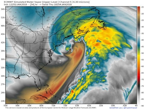


This is SO IMPORTANT that I wish you could take the time to shorten it.
It sorta got away from me . . . but hope folks can look at version I’ll be reposting! I do hope to post an abbreviated version, and plead for some tolerance.