
The map reveal reactions reveal the increasingly provocative and undoubtedly stressful skirmishes along the edges of territorial waters. While not that new–save in the hitting of the unmanned drone, the escalation of confrontations along the airspace occurred in a context of increased economic tensions. At the same time as Trump turns his back on the possibilities of negotiation he claims to hope to promote, arguing that Iran has walked away from the table, he offers a high-handed reading of an outdated globalism of American dominance, in which the traffic of oil out of the Gulf was patrolled by Americans alone. Previous flightpaths of U.S. drones had regularly attracted unfriendly fire as they also flew in areas of Iranian airspace, for reasons not understood or specified, although they were not downed by missiles. Yet the atmosphere of tension reigning between both countries has increased the abilities to interpret anger at crossing a border or a line as a pretext for military aggression. In this context, the notion of shooting down a surveillance drone becomes a provocation for regional war.
U.S. Secretary of State Pompeo, who has never actually spoken to Zarif in two years, condemned his claims as just “not credible,” arguing that “Iran’s leaders know the truth is a dangerous thing.” He claimed that the map Zarif baldly offered showing a “US military drone in OUR national waters” was in fact a fake, taking a page from Donald Trump. Of course, he has shown no respect for Zarif over time: soon after the tiff, Pompeo bombastically arrived in the Emirates to craft a new alliance against Iran, and cast new dispersions on his Iranian counterpart’s assertions. Trump’s allies have gone further, and metaphorically cast oil as the “lifeblood of this murderous regime” that needs to be strangled. It seems open antagonism are President Trump’s “Maximum Pressure” policy; in place of pursuing the Obama-era treaty, tensions around the actual downing of an errant drone–or a drone that seemed headed toward or weaving in and out of Iranian airspace–would not have been seen as if their design was entirely benign. In a tense geopolitical climate where multiple tankers in the Gulf being targets of attack in June 2019, from ; as Saudi facilities were attacked in an apparent quid pro quo, America has ramped up vigilance as international oil markets are looking increasingly volatile. Pompeo isn’t really sure what he wants, here, nor Trump, but demand, as if its were possible, an outright cessation of nuclear development and a halt to what they call aiding proxies in Yemen, Syria, Iraq, Lebanon and Afghanistan that endanger American “interests.”
With Saudis alleging drone attacks on its pipelines, as well as tankers in the Persian Gulf, costs of crude grew by over a dollar in just a day. In such an energy market, Trump has claimed he is “absolutely” willing to send troops to secure to keep that price down. With tankers appearing to be attacked by limpet mines, creating ugly fires that got Washington DC’s attention rather quick, the tense atmosphere has led to Washington accusing Iran as the one pursuing a course of violence, although what it seeks to achieve by hoping to encourage Iran to return to the negotiating table once again about its nuclear program seems an unproductive strategy, resulting from Trump’s own sense of his ability to “get a better deal,” although that ability has never been tested, and his track record seems pretty poor indeed, and his promise of his ability to ensure “they are going to be so happy” even less likely to inspire trust–the disdain of his demand that they act like a “normal” country won’t either.
In seeming desperate to show that he can intimidate Iran and act tough for his supporters, he seems only to believe that he can convince Iran to if respect the unbalanced international energy markets inherited from longstanding Gulf policies of oil extraction and expropriation. For all his eagerness to reject the deal his predecessor achieved, in this extent, Trump as President seeks to follow a map of a globalized world where superior American maps bestowed rights on mastering and monitoring energy markets. But such a map of inequalities seem less likely to be entertained by Iran. Trump implicitly acts as if Iranian maps were either far less sophisticated or second-rate, and seems ready to have his advisers dismiss them as inaccurate if not doctored, even as he has ordered multi-day assaults of Iranian air and coastal defense systems, mine storage facilities, ports, and ballistic missile locations–under pretexts of their aggression against tankers carrying oil–at the same time as launching air strikes on the Natanz and Fordow uranium enrichment plants, uranium conversion facility at Isfahan, the Arak reactor, and Revolutionary Guard bases that are being listed as conducting potentially aggressive military research.
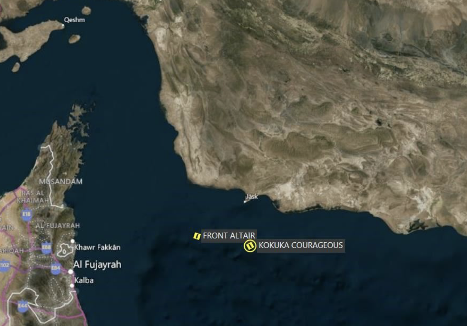
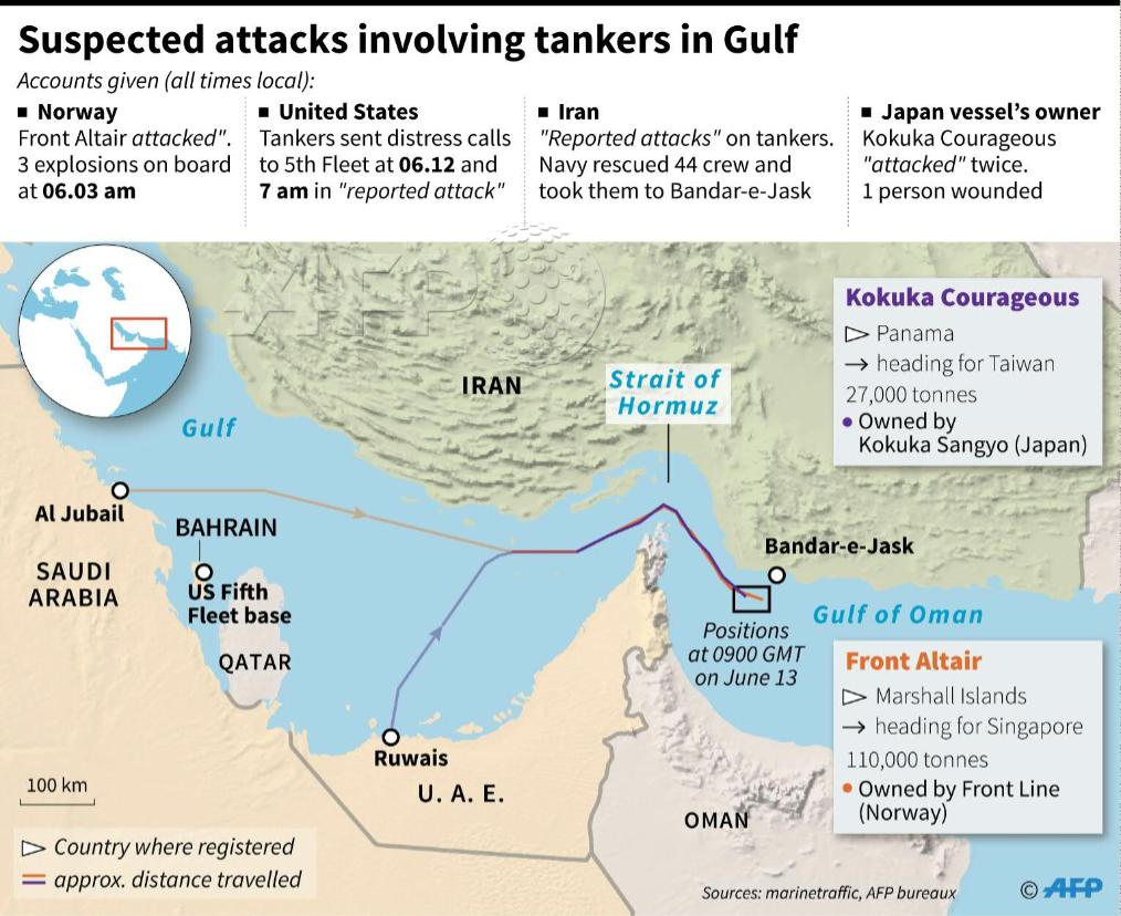
An undercurrent is that America possess better and more trustworthy maps of the Iranian boats that allegedly approached tankers with landmines–spotted, we are told, by American MQ-9 Reaper drones, if without footage, and commercial tankers owned by Japanese and Norwegians, whose crews evacuated in the Gulf of Oman, and argue that these were Iranian attacks against U.S. allies, and hence a justification for war once they are placed, as Mike Pompeo puts it, “in the context of forty years of attacks of unprovoked aggression against freedom-loving nations,” turning the discussion to a demonization of Iran, and on commercial shipping allegedly coordinated by Iran, who denies involvement, as the crude oil in the Norwegian-owned Front Altair seemed to necessitate all future tankers to be accompanied by guards.
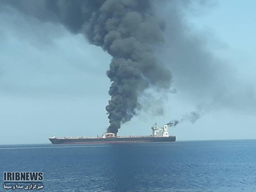
Fires Spreading across Front Altair after Explosions Breach Tanker, June 13 2019
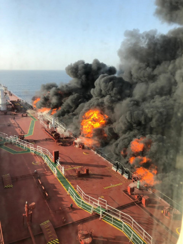
After the explosion of Japanese-owned Kokuka Courageous and Norwegian-owned Front Altair tankers, Pompeo appeared on American TV, branding what he called brazen Iranian attacks as “the latest in a series of attacks instigated by the Islamic Republic of Iran . . . against American and allied interests”–as if already assembling an imaginary coalition to attack Iran; for good measure, he added a car bomb that killed American soldiers in Kabul to the list of Iranian offenses he alleged. “The [American] intelligence community has lots of data, lots of evidence,” he intoned, without offering a coherent explanation for Iranian involvement. By capturing global attention a week before the drone was downed, Pompeo ratcheted up tensions as he accused Iran of “an unacceptable campaign of escalating tension,” labeling the alleged attacks as attacks on American sovereignty, or the stability of the extraction of energy from the Gulf,–even as one oil tanker in question left Iran’s territorial waters in safety after two days, and the other was apparently abandoned. The attacks on the Japanese ship occurred, suspiciously, as Japan’s Prime Minister Shinzo Abe was in Teheran, led Zarif to consider “reported attacks” on methanol shipments while Japanese Prime Minister visited Iran as “beyond suspicious;” Abe must have even rattled the nerves of Iranians by treating safety of oil shipments in the Gulf “a matter of life and death regarding our country’s energy security”–a level of concern particularly unsettling as Japan still is bound to depend on the United States for its military security. the U.S. Fifth Fleet reported receiving two early morning distress calls from each of the tankers or that the U.S. Navy diving experts were quick to arrive to inspect the Front Altair tanker carrying 200,000 barrels of oil in Oman’s waters, first reported hit by a “weak wave” in the Strait of Hormuz. the incident immediately set off global alarms about the security of international oil prices–and news outlets tried to indicate the global scope of the attacks as they were interpreted.
The images that mapped the explosions for Americans had quite effectively transformed the Gulf to an international space, dominated by interests of those geographically removed–the owners of the ships; the destinations of petroleum products; the global economy–rather than of local states. They failed to register the opaque global economic interests that animate and enable the extraction of petroleum crude and the massive transports of Petroleum products passing through the Straits of Hormuz to western industrialized economies, however, or the weblike fashioning which so many interests were at stake in the attacks that the two tankers allegedly faced while, it seems from the map, they lay in international waters.
Bill Rankin has recently reminded us how much globalization has to do with the mutable nature of territoriality in maps, and the shifting nature of the cartographical construction of sovereign bounds in global base maps that were introduced in postwar Europe, from when the Universal Transverse Mercator served to removed boundaries form a natural terrain. But if Rankin suggests we understand globalization by the inherent instability of territoriality, the definition of sovereign space in the Gulf is not so much at stake as the laminations of territoriality and sovereignty that both the United States and local states have sought to redraw about the Gulf Waters, and by which they have done so in order to preserve access to inherited historical access to oil reserves in geographically removed regions, through a combination of global economies, commercial contracts, and disproportionate military strength: the shooting down of the unmanned “Global Hawk” aircraft. which seems to fly across all borders undetected and in defiance of the sovereignty of any national map, airspace, or territorial waters,. and to be the hardware of globalization if GPS is its software.
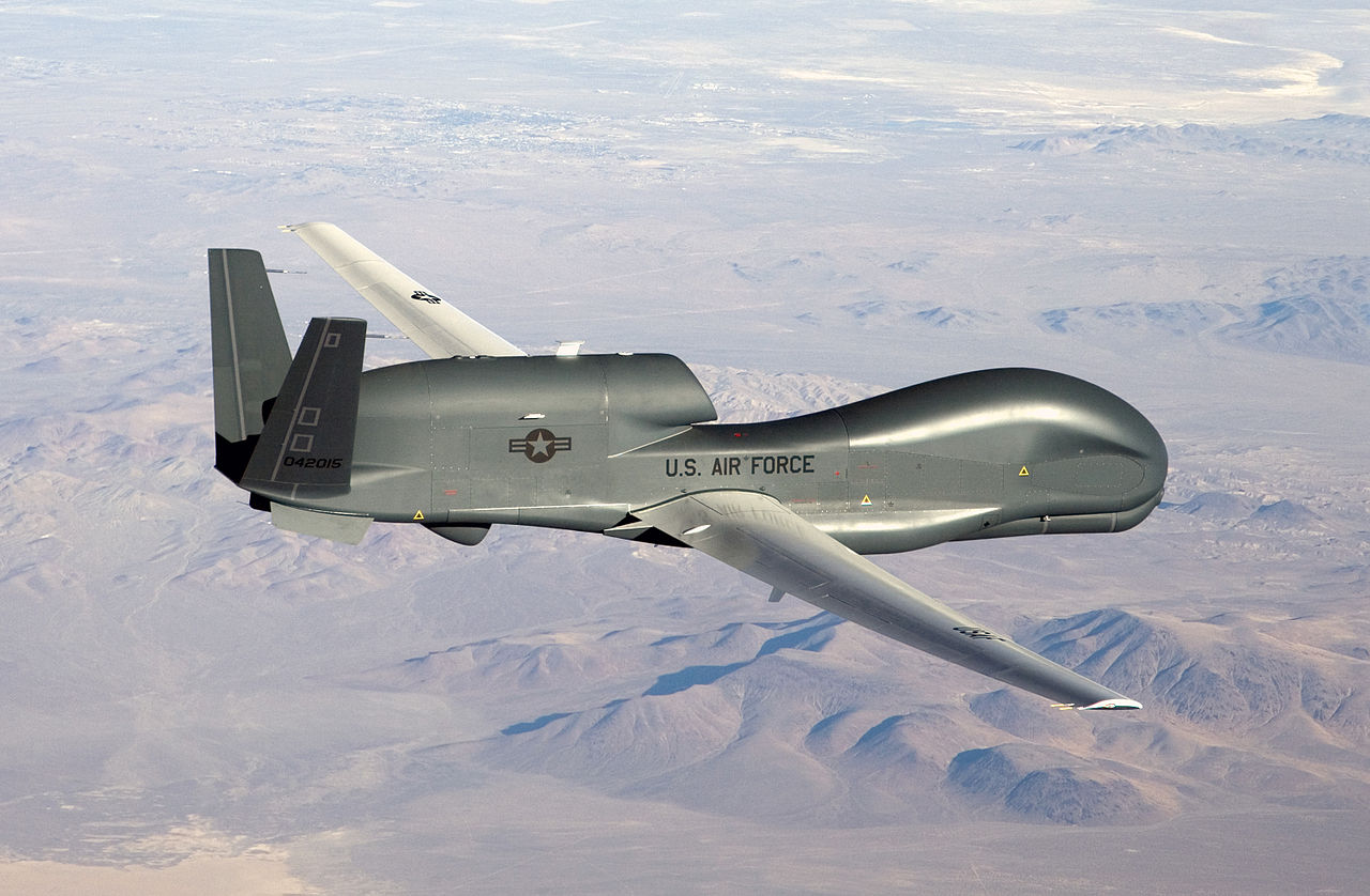
For the Global Hawk drone that is promoted as “currently flying non-military mapping missions over South, Central America and the Caribbean at the request of partner nations in the region,” in addition to the Persian Gulf, offers an ability to surveil the global map that those on the ground cannot perceive or prevent. The claims incarnated in Northrop Grumman’s Global Hawk seems to have been so powerful in Iranian media and to the Iranian state as a dismantling of an inevitable weak point in the American system of global mapping and surveillance that high-flying drone technologies allowed, and the surgical military strikes that they have allowed the American government to continue, in order to cow Iran from staking claims to defend its coastal waters. The lamination of a claim of territoriality over Iranian claims–or over the claims of any Gulf nations–seems particularly striking in the case of the Gulf waters, and in the spatial control that the machinery of a network of high-flying drones seem to have long allowed Americans and global oil corporations. The drone is the club, or police-stick, by which an American vision of globalization is preserved, in other words, as it provides the most detailed prophylactic maps to maintain the global status quo, even if they are allegedly only used at “the requests of partner nations” where the U.S. Army, presumably, has bases,–and that would include Oman and Saudi Arabia, even if not per Northrop Grumman.
Could it be that it is among the laminations within our global maps that the most dangerous points of global tensions exist and will continue to arise? The close brush with a violent explosion of military violence in the oil-rich lands of the Persian Gulf seems to have been narrowly escaped, or prevented, although it is hard to read the open declarations of the current U.S. President, who seems to prefer grand theatrical statements and an advantage to lie in a truly unprecedented sort of nuclear brinksmanship that remains hard to separate from bluster. But the laminations in maps of Iran, the United States, Saudi Arabia and Oman seem to have created something less like a unified GPS image of using the same base map across borders than reading different maps, and investing them with an authority that it will eventually be difficult for anyone to claim distance from. Such is, at least, a new worry in an age of globalization, where national interests can be mapped apart from territoriality and in potentially open conflict with it.
The maps echoed the official pronouncement of U.S. Secretary of States in suggesting the outright protection of abilities of oil extraction seem more clearly as aligning with prerogatives of American interests in protecting global energy markets for Pompeo than respect of Iran’s sovereign territoriality in Gulf, or energy inequalities: the United States appeared all but ready to defend its allies’ access to oil markets in the principle point of transit for all foreign tankers carrying oil and petroleum products from Saudi Arabia, Qatar, Iraq and Kuwait–American allies–and securing the ship that was attacked in Omani waters–suspiciously–in ways the event was cast as an invasion of foreign territory by a “sovereign entity” other than Oman.
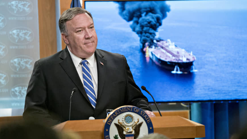
So it seemed in the extremely stunning visual in which Mike Pompeo described the attacks on tankers as the result of Iranian plans in a press conference, even as he presented little actual clear evidence to provide a basis for his accusation, save quite grainy video of unidentified boats. As the USS Bainbridge quickly entered Oman’s national waters to respond to the distress call of the Front Altair after calls sent to the U.S. Fifth Fleet to assist the crew, was not the message implicitly that the United States was there to secure smooth running of energy interests in the region? And as the sailors of the Kokuka Courageous reported “flying objects” that arrived to penetrate the side of the ship, rather than limpet mines, Pompeo’s fragile if potentially ear-catching narrative that cast likely attacks by limpet mines as “efforts by the Iranians to raise the price of crude oil throughout the world”–a narrative that implied the United States needed to be trusted as keeping that price down–may have been far less airtight than thought.

The tankers were not themselves representative of allied nations, but reveal the web of offshore global interests in the extraction of petroleum and tankers’ progress: the Front Altair sails under the flag of the Marshall Islands, despite its ownership by a Norwegian, and the Kokuka Corageous is registered in Singapore: both are creations of the regime of the offshore, allowing them to traffic in petroleum products, in the case of the Font Altair, naphtha from Abu Dhabi, being transported from the United Arab Emirates to Taiwan, while the Kokuka Corageous, which seems to have been hit by an airborne weapon, which punctured its starboard, was carrying 25,000 tons of methanol, from Saudi Arabia to Singapore.
The demand for a dedication to de-escalate tensions from UAE was ignored by Pompeo, however, whose reaction provoked fears of increased logistical difficulties for continuing to transport oil through the Strait in a global oil trade: rather than being ships that were flying national flags, endangered by natural storms on the high seas, as one once imagined nautical risk on the high seas

They were essentially faces of international commerce, acting as nodes or points in a network of the global petrochemical energy posing a danger to the smooth functioning of a globalized world.
Pompeo expressed an American disdain for the hexadecimal tracking of the drone as so much fake news. Yet, Zarif’s tweets seemed to constantly imply or reaffirm, weren’t Iranian maps of the motorized boats taunting tankers and surveillance tools of American drones that infringed Iranian airspace not the superior ones,– even if they didn’t show the clean of geolocation to which Americans are habituated or included Arabic script? In seeming desperate to show that he can intimidate Iran and act tough for his supporters, he seems only to believe that he can convince Iran to if respect the unbalanced international energy markets inherited from longstanding Gulf policies of oil extraction and expropriation. For all his eagerness to reject the deal his predecessor achieved, in this extent, Trump as President seeks to follow a map of a globalized world where superior American maps bestowed rights on mastering and monitoring energy markets. But such a map of inequalities seem less likely to be entertained by many in Iran.

While Trump implicitly acts as if Iranian maps were less sophisticated or second rate, and seems ready to have his advisers dismiss them as inaccurate, even as he . Yet, Zarif’s tweets seemed to constantly imply or reaffirm, weren’t Iranian maps of the motorized boats taunting tankers and maps of American drones that infringed Iranian airspace not the superior ones, even if they didn’t show the clean of geolocation to which Americans are habituated or included Arabic script? Rather than trace the global repercussions of an oil trade, these maps are tracing the routes of massive “Global Hawks” on the borders of a sovereign state, and their longstanding incursions into local territory.
As much as these maps reflect and are the product of different forms of mapping, a gulf exists between the geoepistemologies of each map and its mapping tools–GPS tracking of Americans, and the radar of tracking drone flights on the edge of national territory. One is globalist, and emphasizes the big map ensuring continued access to oil extraction along international shipping lanes, as if such access is easily naturalized and rightful, even of a period of extreme climate change; the other is territorial, and affirms the boundaries that are treated by distinct vulnerabilities in a world where one superpower seeks to impose its technologies of total mapping over the transport of extracted oil across the Strait of Hormuz, and sees them as removed from local sovereign claims, as they are ways of doing business with the elite of Abu Dhabi, the Emirates, and Saudi Arabia, outside any nation’s sovereign claims. The overweening nature of this overwhelmingly global vision has transformed the Gulf into a region whose increased militarization brings a renewed sense of its own increasing vulnerabilities, a sense that the increased ability of monitoring national incursions has no doubt heightened.


I love all this. There are map people and non-map people, and I’ve definitely become one of the former!