
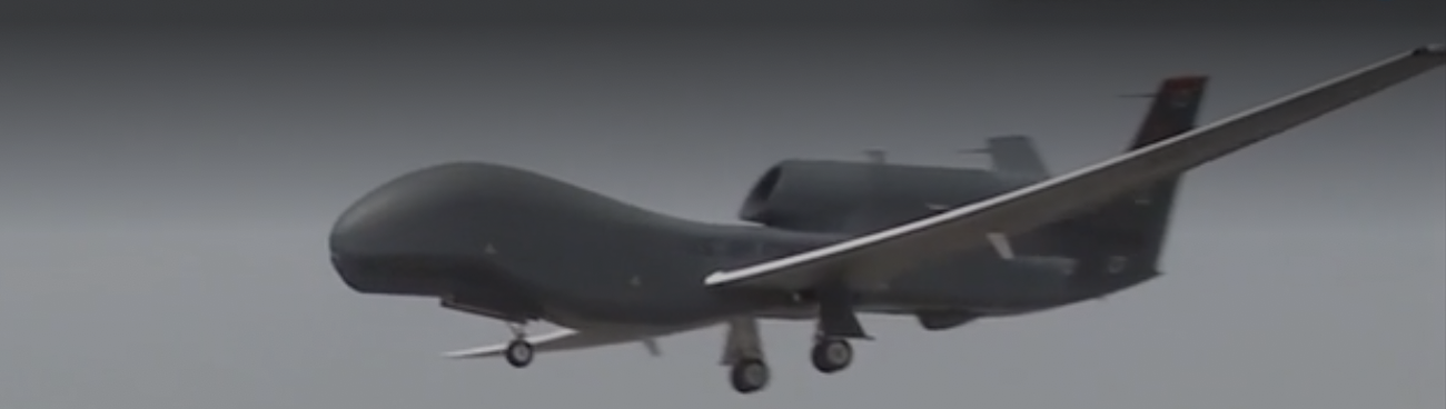
The alternative mappings of the course of the drone and location where it was shot down suggest not only different criteria of measurement, or global projections, but a different way of situating the drone in relation to the gulf and gulf in relation to the world. Although the massive 130 foot wingspan of the drone that cost over a hundred million to create–and our $220 million to manufacture and outfit with the radar, infrared, and electrico-optical surveillance technology, including telephoto lenses, may have made it difficult to track.
But the gap in locations that each government affirms the drone was flying when hit by the Revolutionary Guard may conceal the shock that a drone billed as unable to be hit at the high altitude they fly could only be hit by radar-enabled surface-to-air missile systems of Russian design or origin, that were for the first time able to hid drones flying at an altitude as high as 22,000 feet–formerly far out of the range of Iranian radar technologies. Even if the drone flew thirty-four km from the nearest Iranian landmass, as the US Department of Defense sustained, the Iranian government had so improved radar technologies of its surface-to-air missiles and remote guiding systems to be able to hit the drone as they monitored its entrance into Iranian airspace.
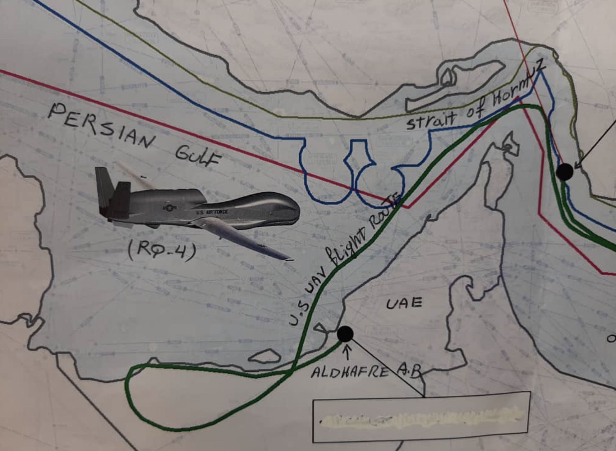
The gap on a news map between where U.S. claimed the drone was flying over international waters should have been one that the surface-to-air missiles used in the past by the Revolutionary Guard could have been constrained by, the three men remotely piloting the drone did not even need to worry about as it flew at a higher altitude than earlier Iranian radar-systems could reach. Although the Pentagon and U.S. military argued the drone was flying some 34 km away from Iranian landscape, and was not over “Iranian territory,” the vigilance to national airspace, and indeed a clearer monitoring of the drone’s flight path in relation to its airspace. The head of the Revolutionary Guards has affirmed that “The only way for our enemies to be safe is to respect our sovereignty, national security, and the national interests of the great Iranian nation,” as per the state news agency, Tasnim, and the Foreign Ministry condemned what it called an aggressive action with the start warning that “any violation of Iran’s airspace by foreign flying objects and declare that violators are responsible for the consequences of their actions.”
The maps in Washington Post and other newspapers of the possible sites where the drone was targeted, or U.S. Army statements about its proximity to Iranian land, don’t really capture the conflicts that are involved, or the distinct sense of territoriality that Iran is openly claiming to exercise jurisdiction over. American aeronautic charts are defined from reconnaissance flights taken at 20,000 feet, but are the maps or radar systems used by Iran different? Or are the Iranian abilities for mapping the entrance of drones into their sovereign space just far more detailed than Americans had presumed? The difference between Iran’s claim of a drone eight nautical miles from its shore (15.3 km)–where Iran claims to have downed the drone it targeted–and the map provided by the Pentagon are considerable– but occurred after the United States had been warned twice about its course, but that “our national security is a red line,” echoing the red line of territorial waters drawn on the below map Zarif later tweeted, in an act whose defiance seems to have led his American assets to be frozen.

The maps were adopted for propaganda value, it is true, when there Iranian parliament took the occasion to praise the Revolutionary Guard for its “overthrow” of American military technology by achieving a “psychological defeat of the enemy after its aggressive [drone] flew into Iran’s airspace.” The derivation of a new protective barrier of Iranian airspace offered by an Iranian defense system deriving from Russia’s S-300 or BUK air defenses was described as an “overthrow of the American drone, the most advanced weapon, [that] has shaken the American psychological warfare equations” and a weighted responsibility of ‘national security” in “a strategic encounter” of American antagonism, taking the event as a needed occasion to encourage morale. Once on social media, the display of these maps and the conquest of the expensive drone’s ruins served as a moral rallying cry for Iranians, much to the anger of the United States, who wanted to strike Iran, but only affirmed “hard-hitting sanctions” that denied access of its supreme leader, Khameini, and the elite commanders of the Revolutionary Guard who had struck down the plane, in response, fashioning them as bad apples who had unnecessarily taken quite aggressive steps through what he termed, with faux-Solomonic -wisdom, a “proportionate response to Iran’s increasingly provocative actions” on June 24, a month after the U.S. blamed the Revolutionary Guards for four explosive mines placed on tankers in the Gulf of Oman, and four days after the drone was shot down.

In short, the dispute over “where” the drone flew when it was shot might be evident in one map, but given the problems of declaring airspace over open waters, a matter of perspective that almost could have led to war–even if the downed drone was certainly flying far above water. New Iranian guidance systems however placed the pricey drone suggest that the more important maps may include the mapping systems that each nation uses; indeed, Iran’s Foreign Minister Zarif quickly issued a tweet showing the path of the drone entering Iranian airspace slightly, as if in a test, and then moving within it more decisively–or with apparent decision. The tweet’s defiant tone, as if designed to puncture the hub rustic over-confidence go evading detection, seems to have led Trump to freeze his American assets to be immediately as if in reaction.


I love all this. There are map people and non-map people, and I’ve definitely become one of the former!