
This problem seemed to come from Hell. The “righteous strike” of a drone-fired Hellfire Missile killed Afghan aid worker Zemari Ahmadi, his nieces and nephews was America’s military doing what it did best–a targeted precision strike. As much as targeting a human target who was instantaneously dismembered as his car shifted into park, the “Over the Horizon” strike cell commander who fired the missile from the drone was firing at a coordinate, and trusting in its authority. United States Dept. of Defense spokesperson John F. Kirby vowed “to study the degree to which any policies, procedures or targeting mechanisms may need to be altered going forward.”
The strike was to be reviewed by former senior staff officers who served in Afghanistan, assigning it high priority as an event that was based both on the lay of the land in the territory of the strike and of the unique capacity and liabilities of drones to both survey the area from human intelligence it is fed. But Rear Admiral Kirby insisted that the strike was only green lighted after the American General at Central Command, or CENTCOM, who remained apprised of surveillance found “a reasonable certainty of the imminent threat that this vehicle posed.” The descriptors of a “reasonable certainty of imminent threat” was itself a wartime coinage, the inheritance of the contradictions of the drone’s ability both to provide impressively detailed imagery from both infrared and image-intensified cameras in the Reaper drone that killed Ahmadi, believed and claimed to having decided to act as an agent of the Islamic State by a car full of explosives, a misjudgment for which no military were ever punished, or ever will be, as the intelligence failure was attributed not to humans, but to a defect akin to software–“a breakdown in process, and execution in procedural events, not the result of negligence”–even if it was in fact unnecessary to protect American troops from a strike from the Islamic State that the drones had detected.
The CENTCOM Commander himself apologized, saying “we thought [we had] a good lead,” the balance between “certainty” and “threat” was not so clearly mapped as the pinpoint targeting of the vehicle, watched for over eight hours. As if in a surplus expenditure of energy at the conclusion to the war, or a final moment of fireworks, the huge discrepancy of wealth and technology between two sides was made manifest in the explosion that took the aid worker Zemari’s life with his nine family members, a final salvo of the Forever Wars. But the striking of the vehicle containing Ahamdi, and which his nieces and nephews surrounded, were perhaps the fault less of a human error–if that was involved–than of a desire for a new method of war conducted in alarmingly disembodied terms, in which “it is exceedingly important to shoot the missile, not at the target, but in such a way that missile and target can come together in space,” as Norbert Weiner wrote in 1948, in a classic work of communication networks in animal and machine, in which human judgement become part of feedback loops, but not ever making anything like what we might classify as ethical calls: the transmission of information in this model is based on the clear transmission of alternatives, and reduction of ethics to so much background noise, based on the probability of how much accurate information was available or at hand.
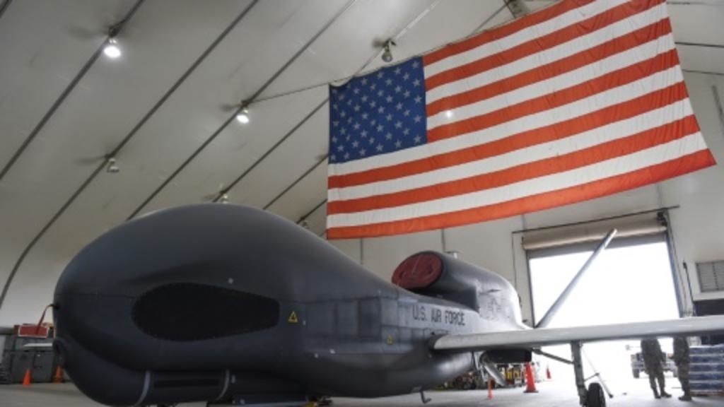
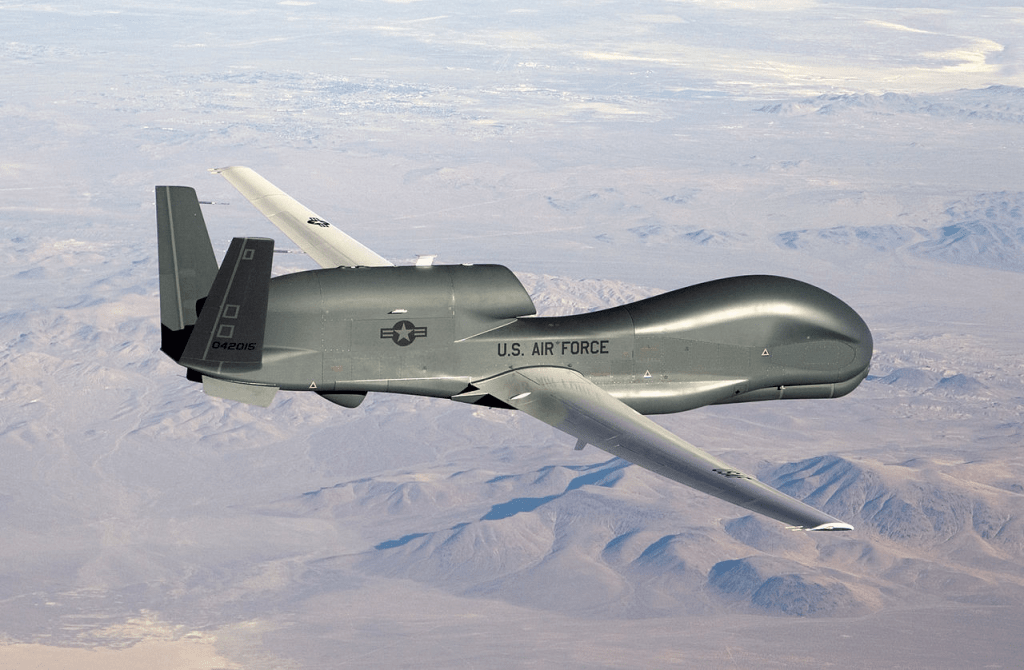
This conflation of viewing and mapping is a creature of the geodetic grid, now enhanced, as never before, with qualitative footage that is real-time, if incomplete. The widely touted surveillance abilities of the Reaper Drone that is able to transport laser-guided Hellfire missiles, and day or night radar, was the “first purpose built hunter-killer UAV,” a precision instrument run by real-time video feed by operators located thousands of miles away was not only a filmic experience as a video that guaranteed its own sense of accuracy, assured by highly refined abilities of mapping that, as all geodetic maps, offer the security of a grid imposed on experience, as a substitute for experiential knowledge, but extends the global network of American military bases into the city blocks of residential housing able to drill down to the very driveway in which Ahmadi was hit. If the justification of “imminent threat” the reaction time from the growing constellation of drone bases” in a secret network of airstrips across Africa and the Arabian Peninsula to assure global military dominance growing from 2013 in the Global War on Terror, to achieve a targeted killing program of which Ahmadi’s death is only the latest fruit. The network designed to ensure the safety of Americans was justified by the Legal Counsel to Barack Obama’s Justice Dept. in 2011 as allowing lawful killing of any member of Al Quaeda or its affiliates of “imminent threat” to the United States, a formulation first used to justify the killing the American-born Muslim cleric Anwar al-Alaki, and his sixteen year old son. If the white paper does not mention quality of intelligence sources, it gave broad legality to aerial killing, stipulating “imminence must incorporate considerations of the relevant window of opportunity” and possible collateral damage to civilians. The geodetic architecture of spatial precision created a new regime of imminence, locking targets into the sights of removed
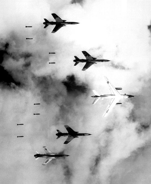
The legal term “imminence” is balanced with a distributed network to dilute responsibility in ways oddly commensurate with the technology of death. The removed visual experience conjured by the Reaper is an ideal cartographic knowledge, equipped with all-weather, day or night radar, a sensor ball bearing image-intensified and infrared cameras in the gridded screen of a target, is unique. Its firing is rooted in an ethically unquestionable phenomenology of film that depends on “what the camera can see,” which legal historian Nassar Hussain argued refined a way of seeing that elides its own mechanical construction and claims a total experience despite its often partial picture of the target in question; it is also a bolstering of the smoothness of the decision to strike a threat that proceeds down the “kill chain.” The moment of impact is geographically removed but also problematically removed from any ethical contract among combatants: it is the most extreme threshold yet of the “maximum range killing” that Dave Grossman, an authority on the psychological impact of lethal force in war, defined as “a range at which the killer is unable to perceive his individual victims without using some form of mechanical assistance—binoculars, radar, periscope, remote TV camera, and so on.” For Grossman, the occlusion of visual perception creates a suspension of ethics unique in military psychology: “I have not found a single instance of individuals who have refused to kill the enemy under these circumstances, nor have I found a singe instance of psychiatric trauma associated with this type of killing.” It was this unique psychology of killing, cleansed of all trauma, it appeared, that ballooned in the military theater of war in Afghanistan.

“Imminent threats” were intentionally removed scrutiny of targeted killing from public scrutiny by a legal whitepaper, commissioned by the U.S. Dept. of Justice in 2011, to confirm the lawfulness of a strike against an “imminent threat” of any senior or operational leader of Al Quaeda or affiliates just after the height of drone strikes in Pakistan and as drone strikes in Afghanistan reached astoundingly routinized presence. But the equipment of drone with lethal missiles from 2001, in the heady early days of a Global War on Terror after 9/11, transposed the legal language commonly used as a term of justification, to targeted killings as the 2002 strike against Al-Harethi in Yemen from a secret American base in the Horn of Africa, and the growth of drone strikes in Pakistani territory, whose legality the US government had effectively confirmed as part of the state of war and the landscape of aerial warfare that was increasingly incommensurate in scale of destruction with the terrorist attacks on the ground or IED detonations.

At a time when ISIS had effectively internalized the danger of a sense of western besiegement, and the United States had almost amplified its power to suggest that waves of besiegement were utterly insurmountable and impossible to defend against, the arrival of a final Over-the-Horizon strike of a Hellfire missile seemed a parting strike of particular cruelty, by accident effectively perpetuating the inevitability of a continued narrative of besiegement for the world; as the escalated pummeling of ISIS presence in the hills of Peshwar and Afghan provinces had provided ample evidence of besiegement attempting at exhausting the “enemy,” in record numbers, over a decade of intense bombardment focussed firepower one final time on a residential courtyard in Kabul were someone far away had judged an Al Qaeda affiliate was parking a carload of explosives.
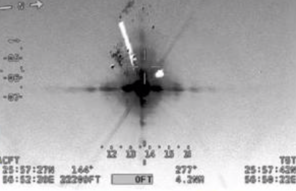
There are problems of balancing an awesome strike ability of a Hellfire missile, a missile conjuring the eternal fire faced by the dammed with a “righteous strike,” and the scale of local damage it can cause: the death sentence that the missile passed as a remotely tracked technology of obliteration was invested with curiously religious terms, the fire of damnation a sentence of divine wrath, sending the fire of hell to the courtyard of a Kabul family residence to shatter the life of the wrong man who had been tracked for eight hours by Over-the-Horizon Strike Cell dedicated to disrupt the Islamic State Khorasan. But this time the Over-the-Horizon strike in Kabul was, if precise, focussed on the wrong white sedan, as the intelligence about the car that was being tracked for over four hours was terrifyingly incorrect. The poor debut of “Over-the-Horizon” strikes was a bad omen of the value of geospatial precision.

Jim Huylebroek for The New York Times
Were the mechanisms for firing the laser-guided missiles encoded in the authority of the mapping tools that sent the laser-guided Hellfire missile to Kabul, as much as in faulty intelligence, and the limited guidance on targeting individuals? In what was almost a bravura use of force, American military drones fired Hellfire missiles as the airlift continued, on the eve of the United States departure, pointing to the appearance of secondary explosions as fireballs to indicate presence of explosives inside vehicles that ISIS operatives might drive into the airport for a second suicide attack. But if the strike was “deliberated” and the information military had collected “all added up,” the rules of engagement of airstrikes, as much as the human intelligence, implied deep ethical problems of trusting in the logic of maps to sift through evidence with greater accountability, especially as we seem to be approaching a threshold of increased engagement without men on the ground in Afghanistan, in developing an “over-the-horizon” strategy for the immediate future, as President Biden pursues his commitment to fight ISIS-K without actually increasing civilian deaths.
Marcus Yam/Getty Images
The mechanics of the decision-making process that led to fire a drone that later killed Ahmadi and his children, nephews, and cousins is under review, but the verbal and epistemic confusion between what was first described as a “righteous strike” of vengeance, evoking the theory of “just war” that was invoked by President Barack Obama in invoking “just war theory” to rationalize the use of the military force not as a wanton or needless display of power and with the hope of saving lives to prevent the loss of lives, required, in his hope a “near-certainty of no collateral damage.” And while this was of course collateral damage of the most extensive time, the coverage of the extent of mis-targeting of believed terrorists reveal a terrifying cheapness of life, undoubtedly only able to be researched in detail for the jaw-dropping mistake of targeting of innocent civilians by a laser-guided missile due to the density of journalistic coverage of this particular strike, and journalistic presence documented the costs of erroneous strikes and the scope of civilian casualties as horrific as carpet bombing–if far more surgical–as if this were a far more humanitarian form of war whose precision could be labeled just. We were able to see the Taliban checkpoint that let in suicide bombers to Kabul’s airport, causing almost a hundred and fifty deaths, we became convinced of the ability of targeting precision strikes of the perpetrators of similar crimes, and amped up the intelligence networks to scour the city for signs of any activity appearing that it demanded to be targeted, and snuffed out.

(Planet Labs Inc. via AP)
Precise targeting, unlike bombing raids of the past, provided this certainty, or was supposed to offer surety of not being needless. But if such near-certainty depended on a map, it rests not on the accuracy of mapping. The strike that killed Zemerai Ahmadi — and ten of his family members–was mistakenly categorized as a “righteous strike,” killing an innocent aid worker and his family members. While it occurred in the heady atmosphere of retaliatory strikes for attempt to sabotage the withdrawal from Kabul’s airport attempted to be just, the slippage between the logic of targeted bombing and justice became apparent. It was a lurch to affirm global strength, more than justice, in using a technology of geolocation that had evolved to coordinate hand in glove with surveillance from Reaper drones. The ability to pinpoint track the progress of one car tagged as an imminent danger.

The mistaken of surveilling and targeting a young Afghan civilian in a Toyota Corolla was terrifyingly akin to the senseless bombing campaigns of South Vietnam, North Vietnam, and Laos, or more terrifying. Surveillance of Kabul and its airport were much better than Vietnam, by remote satellite and drone photography, the ability of such targeting–and the rush of such precision killing–seemed to follow the logic of the map, as much as people on the ground.
1. The maps used to conduct action at a great distance in Vietnam were not as transparent or evident, but they were for the time. In the 1960s and 1970s, they offered grounds to pose the eerily analogous question of the extent and expanse of the globalist claims of American power. The trust in the accuracy of maps provided an eery precedent for the confidence in strikes an old theater of empire, a theater once defined by imperial maps. The surety of the strikes that the UTM and LORAN B offered to American pilots existed in two theaters–the arena of the map that determined the strikes and the geographical space to which it corresponded, and old imaginaries of imperial and colonial power. The British empire was driven from Kabul in 1842 and 1843, and the French hold on Indochina had led them to withdraw; as the mapping techniques of post-war Europe led the United States to inherit Southeast Asia, global technologies of mapping opened the possibility of launching strikes that would offer lasting reminders as America withdrew from the Forever Wars in Afghanistan, leaving as the English did from both Kabul and Kandahar, but, in an attempt not to be forgotten, leaving a lasting imprint of the power of long-distance bombing. If combatants of most all wars fight with different maps, often reflecting differences in military intelligence, both these post-colonial wars were defined by the drastic dissonance of radically different maps of geospatial intelligence, one from the air and one on the ground, and the pursuit of a stubborn logic of air maps as if they offered both superior exactitude and geospatial intelligence, modernizing the struggle for control by defining a logic of modern military operations by which to understand and to shape the “sharp edge” of war.
The beginning of the end of American Empire has been recently pegged to 1972, a year that marked and took stock of the the end of a huge expenditure of sustained bombing drives with little apparent enduring accomplishment. The geospatial logic that drove such earlier long-distance aerial bombing campaigns in Vietnam were driven by perhaps misplaced confidence in how maps enabled and facilitated military action at a distance: maps offered a logic, if there was one, for conducting the over six hundred sorties and operations over eight and a half thousand miles away. There is an eery analogy that we have the most complete and exact database for bombing raids of the American military in Vietnam, coordinates that were painstakingly compiled by Americans, so analogous to the geodata of thousands of drone strikes in Northwest Pakistan and Afghanistan, from 2004-2018, that the New American Foundation asserts the vast majority–over 80%–of those killed, were militants, though the Brookings Institution counters that drone strikes killed “10 or so civilians” for every militant who died,; Pakistan’s Interior Minister complained vigorously that a preponderance of the killed with civilians–especially in habitual follow-up strikes, targeting those responding to victims of the first hit, targeting of funeral processions, or mourners, or simply less surgical strikes. In an attempt to respond to these attacks from above, the Taliban’s weapon of choice was improvised explosive devices–literally, IEDs, placed on roads and activated by radio signal, mobile phones, or triggered by victims who step on them.

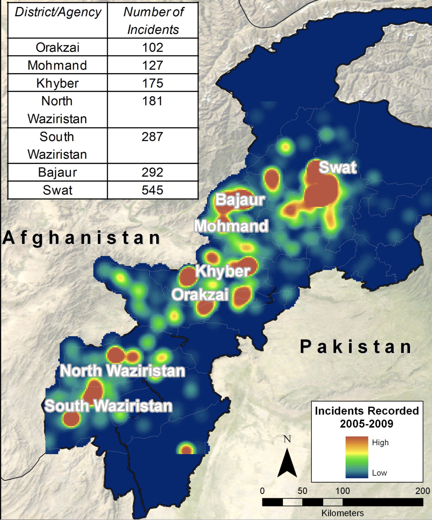
The warscape that developed 2004-9 of explosive shells, made often from diesel or fertilizer, along the major Afghan highway by the border with Pakistan where the Taliban was geographically contained–an increased density of which was tracked by Paul Scruton in the screen shot maps to the right of the map. The first attachment of a Hellfire missile to a drone followed the sighting of Osama bin Laden by one of the Predator Drone of the sort that flew across Afghanistan from September 7-25, 2000, in search of the terrorist who was wanted from 1998 suicide bombings in two U.S. embassies, his first strike at American territory; the unarmed CIA Predator was able to laster-illuminate and geolocate him so that it tracked him fro almost four and a half hours, but he could be hit by a Tomahawk missiles, but the time-lag for firing Tomahawk missiles failed to guarantee a similar sort of accuracy; as the new tool of the CIA and US Air Force were mounted with Hellfire missiles, they sighted and shot at Mullah Omar in 2001, but missed him, destroying only his car.
When Barack Obama assumed office in 2009, he tweaked George Bush’s invasion of Afghanistan by rehabilitating the “just war” theory, of medieval origin, formulated by Christian and protestant thinkers. Obama chose to rely on the accuracy and surgical nature of precision strikes as surgical means of not striking civilians, or focussing on enemy combatants, although the berth of such distinctions lay in the military or CIA: ifAfghanistan became the terrain for “the future of our military,” where Predators defined the mobile “edge” of warfare waged overhead and across borders. Targeted assassinations by CIA and USAF targeted the Waziristan region, mapping the region with pin-point in the notion of a “just-war” theory, rehabilitating an ancient doctrine of right conduct in war–“jus in bello” doctrine of Christian thinkers–by modern tools of geolocation, leading to the escalation of pin-point targeting by drone-fired missiles. In the face of global opposition to the use of missile enhanced drones as tools of targeting objectives in war in the mountainous areas of Pakistan province where the Taliban had fled by 2011,–

–and, from 2012, the CIA went out of its way to try to design alternate missiles to “shred” vehicles and their inhabitants, but without blasts, to attempt to minimize “collateral damage” or killings.

By the time the final American forces were set to ferry the final civilians from Kabul, however, the logic of drone strikes shifted to the home front of Kabul, set motion by the terrifying suicide bomber who struck Kabul’s airport, killing 143 Afghans and 13 American servicemen. In what was either the last gap or new frontier of geolocated killing, drones targeted Hellfire missiles in pinpoint strikes across Afghanistan, in “just” retribution of the fear of further K-ISIS suicide attacks on the ground during the last days of American presence in Afghan territory focussed on flights departing Kabul, revealing an ability of surveilling, targeting and striking far into the country as American forces departed the ground, as if to alert the Taliban of the continued proximity of CENTCOM bases in Qatar.

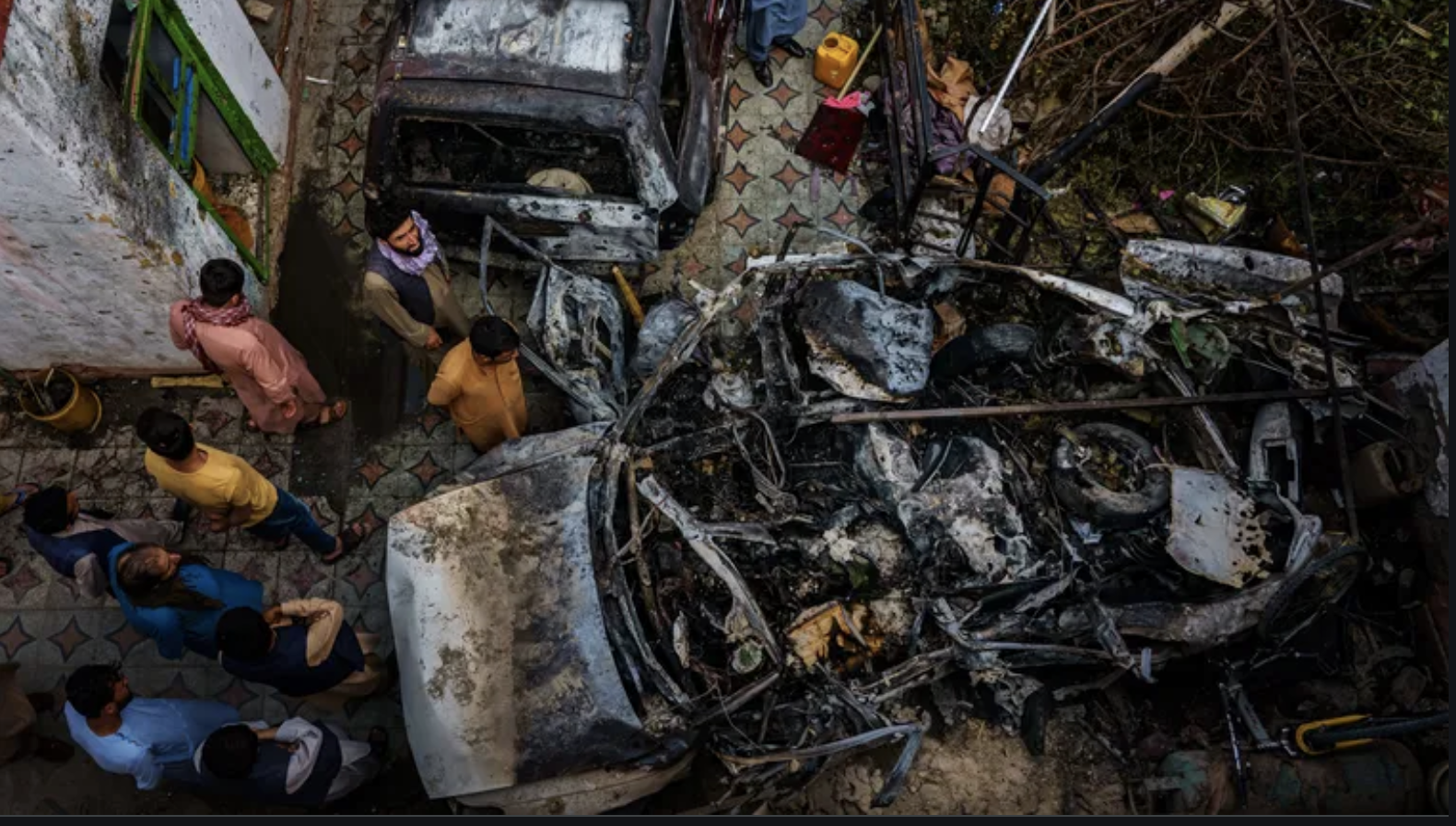
However celebratory the drone strike seemed, hellfire missled that killed Ahmadi suggested the haunting return of a lack of justice on August 29, as twenty pounds of explosive struck the car of the breadwinner of an extended Afghan family, with seven children who depended on his work. The children who had rushed out to greet him as he pulled his own white Toyota Corolla into the driveway of his personal home were not seen by the man who fired the drone missile, who felt secure no civilians were nearby. As we examined footage to detect the alleged secondary explosion, we found a weird echo of the airstrikes of an earlier war removed from our continent. While much comparison between the messy tactics and poor planning American withdrawals from Vietnam and Kabul spun, the incomplete coverage of the “collateral deaths” of civilians from the strike led to the military’s eventual backpedalling of its story of striking ISIS-K as an act of counterterrorism or “righteous strike.”
It was only due to careful investigation on the ground that the horrendous mistake was discovered. Reporters used footage from security cameras to follow the forty-one year old aid worker before he was driver targeted by the Hellfire missile suggested the poor intelligence which operators of “strike cel commander” who had been operating the drone in Kabul. Even as we await analysis of the decision-making mechanisms, we wonder a the high degree of certainty in public statements, even as questions circulated from the start of accurate video analysis of an after-blast confirming, as was claimed, that the Toyota Corolla was carrying a payload of ISIS-K bombs, and the lack of a mechanism of review before the drone strike. The accuracy of targeting the car was questioned by journalists as Spencer Ackerman all too familiar from the targeting of civilians that had escalated in previous years. Although announced as compensatory for the deadly suicide bombing outside Kabul’s airport, killing Afghans and thirteen U.S. military, as a second drone strike on ISIS-K leaders in Nangarhar Province of an “Islamic State planner” in retaliation for the deadly suicide bombing–and entranced the world with the surgical take-out of the very operatives who allegedly planned the airport attack that killed thirteen American service men and 146 Afghans, as they rode a three-wheeled truck near the Pakistani border from 7,350 miles away in the Nevada desert, injuring an associate but killing the two men immediately. There was a perfect symmetry in the image of men who were riding in a tuk-tuk being obliterated by a strike that left a crater four feet deep.
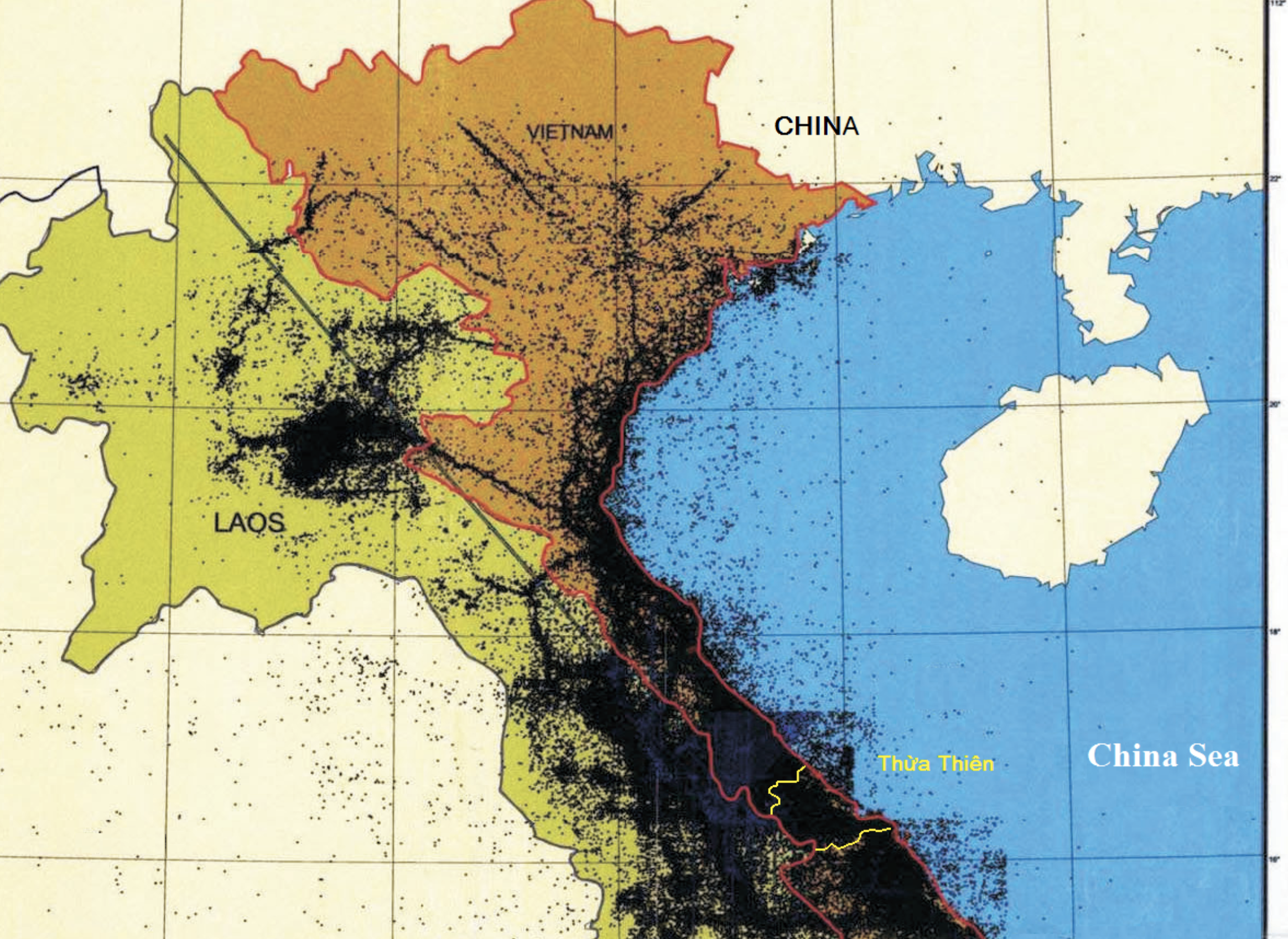
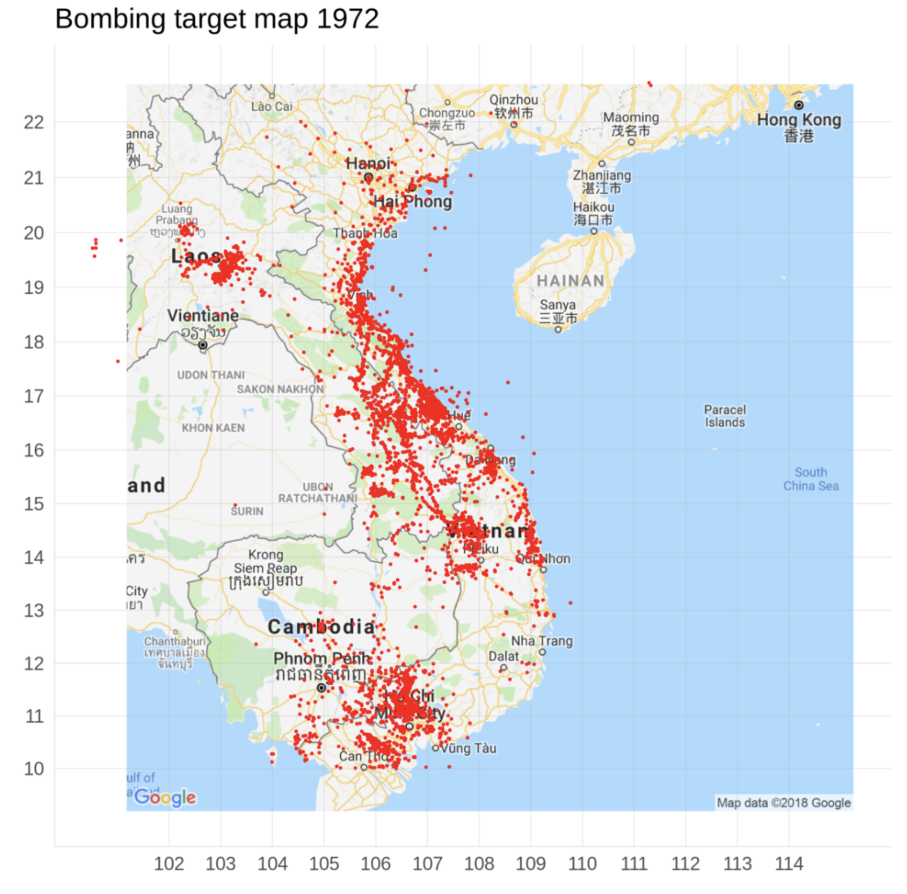
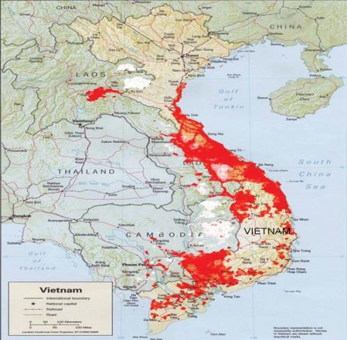
While removed in time, the bombing campaigns in Vietnam have left precise geodata for bombing raids so comprehensive to be able to map cumulative raids over time. The result privileges strikes over deaths, in the eerily lifeless and quite terrifying record of Bombing Target Maps,–charting sustained campaigns of bombing at a distance waged in maps. This blog considered human costs of aerial perspectives both as a result of the acceleration of bombing campaigns in World War II and how maps jusfitied and normalized the Atomic bomb dropped on Hiroshima. As the longest and least accomplished use of maps to sustained military engagement at a distance, is impossible not to consider the retrospective view it offers and reveals on the logic of the role of drones in Forever Wars. Systematic carpet bombing of Southeast Asia was pursued 1965-1973 as if by a logic of mapping, escalating by 1972 in a failing attempt to illustrate global dominance. The increased exactitude of the map becam a rationale for the power to wage war from afar, both to compensate for a lack of information on the ground, and to compensate for more irreducible problems of distance: mapping tools promised a logic of the ability to operate smoothly across frontiers. The unprecedented global coverage of GPS coordinates was administered and run by the United States for Vietnam through 1975, long after the war concluded. But the role of maps in waging war early emerged. If the United States in 1959 had blocked adoption of new standards of global projection, perhaps linking knowledge to power, the Army Service had recalculated surveys of Southeast Asia–Cambodia, Laos, and Vietnam from the global projection that became a basis to collate new geodata–the Army relied on for staging helicopter raids in Vietnam, and, later, for long-range bombing campaigns.
Not that this was always smooth. Despite troubling distortions inherent in the UTM along South Vietnam’s north-south axis and border with Cambodia, coordinates provided a basis for conducting war at an unprecedented distance, even if they would necessitate revamped geodetic networks to minimize built-in distortions.
Hatfield Consultants, Ltd; Ordinance Data Prepared by Federal Resources Corporation
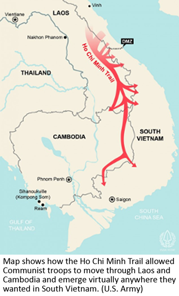
Aerial strikes offered a sense of security, notwithstanding, and aerial sorties that continued to exercise claims to global power even in an unfamiliar theater of combat, evident in the dark lines of ordnance dropped along fairly fixed flight paths on what were deemed strategic locations in North Vietnam, and dense napalm dropped in the Thura Thiên region, where the saturation with napalm provided a carpet bombing of unprecedented scale, with limited sense of the effects on the local ecosystems. The planes’ almost indiscriminate blanketing of the strategic Thừa Thiên province and mountainous border with Cambodia where Việt Cộng hid were blanketed with ordnance and herbicides including Agent Origin, creating a massive deforestation there and on the network of roads known as the Hồ Chí Minh Trail.
Serial Aerial Bombing by United States Air Force in Southeast Asia, 1965-1975
Hatfield Consultants, Ltd; Ordinance Data Prepared by Federal Resources Corporation
Despite the bracketing of huge ethical questions and costs, the authority of maps assumed huge costs as they were were able to conceal huge liabilities, changing the nature of the battle line at which we were now, as a nation, waging war, and its ethical costs: for we were bombing locations, not people, and the people were faceless who the bombs were targeting, othered, and in the national imaginary all but erased. It would take a force of consciousness, indeed, to place them on the map–on the ground photography remained relatively rare. And it is the ability to erase people by dots that provided, this post argues, a similar logic for the expansion of drone raids and drone-delivered bombs.
As bombing raids hit the the Seventeenth Parallel, the war was fought on a map: as much as Võ Nguyên Giáp revealed his military tactical genius as military commander of the Việt Minh, who had developed with stunning success the principle of Sun Tzu in successfully applying minimum military force to maximum effect in deploying light infantry in the First Indochina War, and in engineering of the network of roads known as the Hồ Chí Minh Trail, whose targeting continued in the war, even as its north-south course were distorted in UTM projections. The uncertainty is almost registered by Americans turning for solace to sing Toby Hughes’s “Ho Chi Minh Trail,” a wartime blues to the tune of “Billy the Kid,” as a blues of airspace: “When you fly on the Trail through the dark and the haze/It’s a think you’ll remember the rest of your days./A nightmare of vertigo, mountain, and flak,/And the cold wind of Death breathing soft at your back“? “Uncle Sam needs your help again,” is the mock-resolute start of another of the many songs that tried to process distance and space during the war, “He’s got himself in a terrible jam, way down yonder in Viet Nam,” as was no better evident than in targeting the elusive Hồ Chí Minh Trail.

Americans administrators plagued by lack of knowledge about Southeast Asia or South Vietnam’s leadership relied on maps crippled by distortions. If the blues developed on the plantation, the wartime blues was a lament popular with American pilots as a new folksong of a technological divide pilots sung for psychic stability seemed to balance the demands they shouldered and fears–“the trucks must be stopped, and it’s all up to you,/ So you fly here each night to this grim rendez-vous”–as each sortie tempted fates in contested military space above the Trail; they watched from above “trucks roll on through darkness not stopping to rest,” consigned to their fate nervously navigating airspace by charts, “our whole world confined to the light of the flare,/And you fight for your life just to stay in the air./For there’s many a man who there met his fate,/On the dark roads of Hell, where the grim reaper waits.”
Carpet bombing was hardly comfortable, but was filled with fear. And one is filled by an eery apprehension at the ease with which geolocated records of bomb strikes in North Vietnam, South Vietnam, and Cambodia translate across time into a Google Maps platform, and the translation of the coordinates to a geospatial grid that we all have come to adopt to navigate space. UTM grid zones in Southeast Asia, as Bill Rankin noted, split in inconvenient ways in Southeast Asia, and although bombers were relying on them in raids that spanned over five years, As the provisional line of demarcation between North and South Vietnam, the so called “DMZ” of the Seventeenth Parallel Mendès France negotiated in 1954 was pounded twenty years later with all the firepower America could muster, trying to secure its border by a crazy huge show of power at a distance.
The result of these compound offensives was to riddle the countries with some 2.7 tonnes of explosives, as we were asked to keep our eyes on a static maps on television screens. This was described poetically as “carpet bombing” or continuous bombardment, first used only in 1944, in response to destructive V-1 and V-2 bombs, to mark a shift from the largely targeted bombing of industrial sites in the war. The sense of a lack of restraints or targets dramatically grew in the Vietnam War, as a no holds barred method, long before Ted Cruz vowed to recommit American to the carpet bombing of the Middle East to “utterly destroy ISIS,” asserting, as if in a perverse science experiment, that while he didn’t “know if sand can glow in the dark,” he would ensure American planes bomb ISIS positions until the sand glowed, in 2015,–intimating a carpet bombing of nuclear proportions. Donald Trump amped up Cruz on the campaign trail in Iowa, by promising not only to “bomb the shit out of ’em,” and “bomb the pipes, bomb the refineries, and blow up every single inch” of refineries to prepare for several months of rebuilding of pipelines by Exxon to “take the oil.” Since the debut of smart bombs in global video during the 1991 Gulf War, the sense of carpet bombing seems to have been consigned into the past, with the trust in the security of drone-fired bombs from 2003 promising to strike targets in a far more humanitarian way.
As the Vietnam War intensified, the long year of March 18, 1969-May 28, 1970 brought daily bombing of Cambodia, all but omitted from the entry of troops into Cambodia we watched on a static map on black and white televisions. Even as the escalation of disproportionate bombing campaigns that only ended on August 15, 1973 grew, they set a standard of sorts for the elegance of airborne strikes from afar.
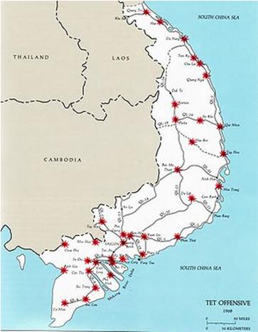
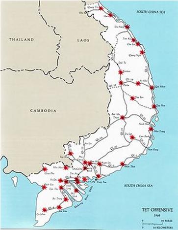
Is it only a coincidence that after serving the nation as Special Assistant to the Undersecretary for Policy in George W. Bush’s Dept. of Defense that the right-wing columnist who has romanticized Gen. Custer devoted time to dispelling the “flawed Tet mythology still shaping perceptions of American military conflicts against unconventional enemies and haunting our troops,” completing This Time We Win: Revisiting the Tet Offensive (2012), winning praise from Henry A. Kissinger, who agreed that “the self-perpetuating myth that the Tet Offensive ended in a defeat for America continues to do us harm,” while endorsing Jerome S. Robbins’ re-examination of the bombing offensive “through the lens of terrorism, war crimes, intelligence failures, troop surges, leadership breakdown, and media bias”–as if to champion the very losing strategy that informed bombing raids in Afghanistan.
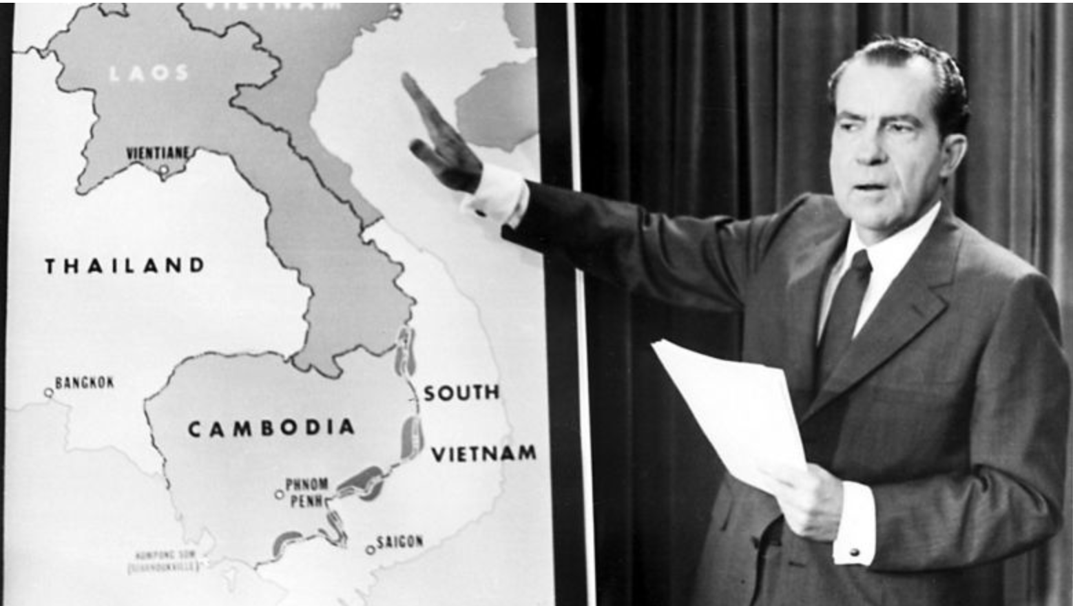
2. The limits of local intelligence recalled the opaque maps before which an earlier Commandeer-in-Chief who, convinced of the logic of military strikes, attempted to project assurance at having directed American troops to enter Cambodia in April, 1970, as bombing grew. Just two years before the continued expenditure on aerial bombing campaign seven thousand miles away revealed a failure to reach military objectives announced a start of the decline of the American empire, the drone strike at the old colonial city of Kabul CentCom ordered revealed a continued commitment to the logic of military engagement by drone that animated the logic of war under an inauspicious promise to Maker America Great Again: the conducting of increased bombing strikes eight and a half thousand miles away would grow in intensity from 1970, but the argument Richard Nixon made was not apparent, as it rested on a geospatial map, but used the crude maps of boundaries of states few Americans were familiar–Laos, Cambodia; South Vietnam; North Vietnam–that hardly reflected why such intense bombing would be occurring around the seventeenth parallel, or mapped a clear vision of strategy.
Even as we knew enough to be skeptical of his map of crude cut-outs, remembering Dresden Hiroshima, and My Lai aggression against civilians, but knowing we had heard stories from reporters on the ground about its intensity. And so we watched the maps of new offensives, distrusting escalated air bombing in times of war–if we knew not to trust them, we took to the streets in protests because we remembered, and because the official news maps of selective hits in one offensive was a partial story–and the danger of what was being targeted by a carpet of explosive bombs dropped.
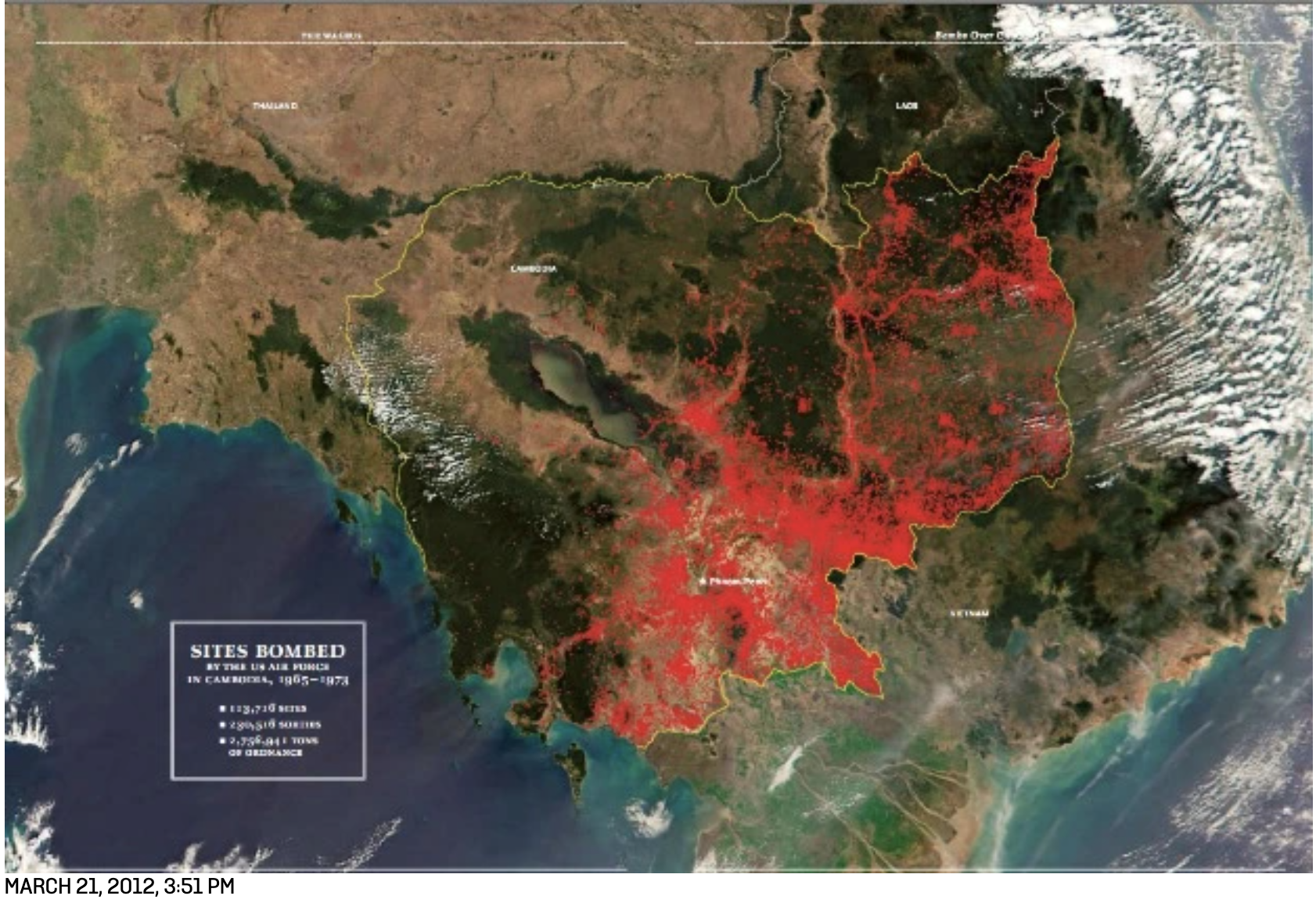
–hardly mapped the increased intensity of air strikes of carpet bombing, the new illustration of force that blanketed the nation with strikes to cover borders between north and south Vietnam and the coast, as Air Force data reveals, releasing over two and a half million tons of bombs on over 115,000 sites in Cambodia, from 1969-72, of which over 11,738 were indiscriminate–with the blatantly false assurance from the military commander in South Vietnam, who requested the sites be targeted in a neutral country, that Cambodians did not live in them, in the wave of secret bombings ordered in violation of international law, and quickly developed by Nixon’s National Security Advisor Kissinger–

The unprecedented concerted orchestration of carpet bombing campaigns by air sorties attempted to wipe out all VietCong bases in eastern Cambodia, vaunted precision in dropping 7.5 million tons of bombs across Laos, Vietnam , and Cambodia, between 1965-75, from Operation Rolling Thunder (1965-68) and Operation Steel Tiger (1965-68), to the extended campaigns in Laos of Operation Barrel Roll (1964-1973) to Cambodia, before Operation Menu (1969-70), blanketing the nation and creating untold civilian deaths and injury in a show of force.
The latter raids covering the country in toto, but to target Khmer Rouge ranged widely across borders of Cambodia and Laos, which was facing a communist insurgency in its borders, and the nation Vietnam had invaded became central to the Domino Theory that rationalized an expansion of boming across borders, before returning with intensity to the seventeenth parallel from 1971-2, trying to hit precise coordinates, and effectively carpeting the old DMZ with bombs. There was something weird, as from a nation of the crossers of borders, we flew bombs across borders, carpeting regions with devastation, from the shorelines of Southeast Asia, to the interior, to the shore again, this time with even greater intensity and around what was then Saigon.
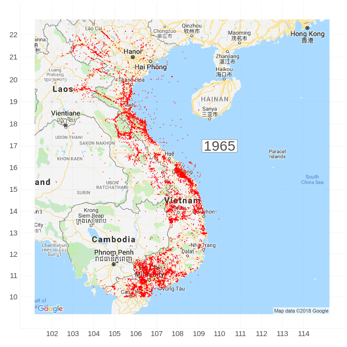
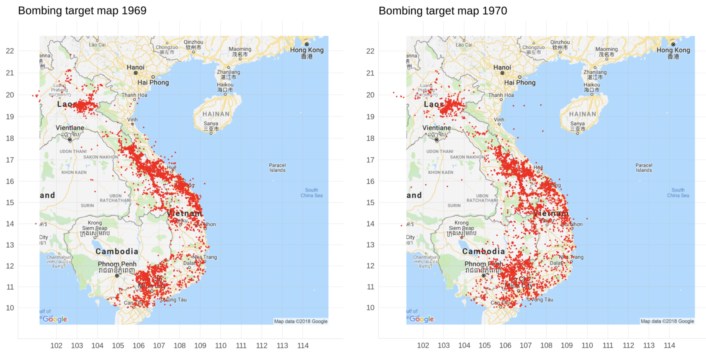
The intensity of carpet bombing was astounding in Cambodia and Vietnam, literally coloring huge swaths of the country red, in these maps that use red dots for cumulative tallies of bombing strikes.


The danger of those bombing strikes on civilians were rarely described, or even comprehended, at a distance. But visualizing the faces of the civiliians whose towns and life were disrupted so violently became a basis for protesting the war–and a crystallizing factor in antiwar protests as the bombing campaigns grew–as the ends of carpet bombing as a targeting of civilians nonetheless grew all too painfully clear, as the very intensity of such carpet bombing created a new architecture of destruction in an already profoundly unethical war.

3. Precision strikes seemed more humane than carpet bombs. But the precision bombs of the Forever Wars were, perhaps haunted by those images of civilians with targets on their crudely drawn heads, trying to advertise themselves less as a global over-reach of the targeting of precise strikes in another hemisphere, a campaign that in fact began, back in the response to the apparent hubris of 9/11, in the battery of B-52’s brought out from retirement, before the Defense Department hit on the new idea of acquiring drones and investing in drone technologies, a budget that has risen to above $7 billion by 2021, whose use is severely restricted in American airspace, but seems the perfect medium for fighting forever wars, on which the United States has come to rely since at least 2005. Fighting the Forever Wars and for counterterrorism programs, a new logic of military engagement, although the program that was first used in 2003 to strike targets developed in secrecy as a way of blurring the “sharp edge of battle,” described by British military historian John Keegan as incomplete or elided in most military histories. Now the “sharp edge” is both everywhere, blurred, and intentionally difficult to see.
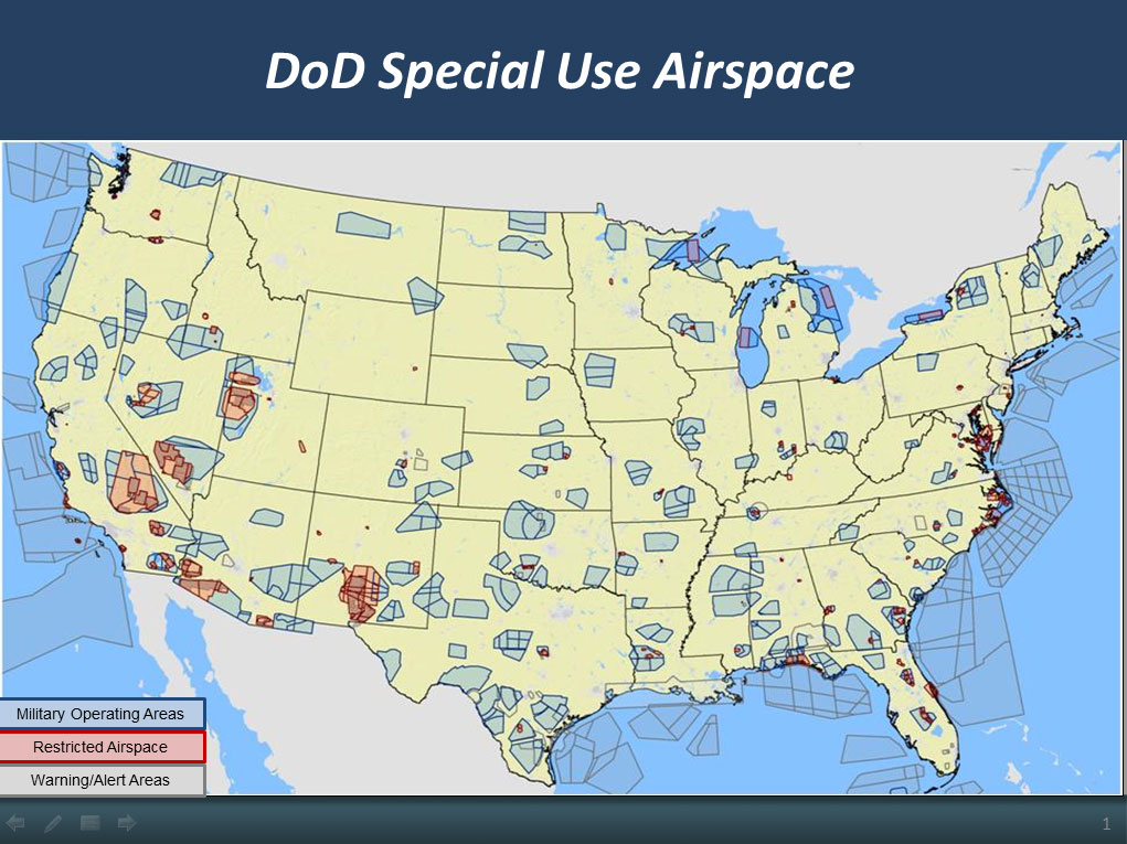
The airspace for operating for the 11,000 drones or “Unmanned Aircraft Systems” in the United States that the U.S. Department of Defense currently owns and operates in American airspace are far from civilian centers in the United States–but the logic of pinpointing strikes 7,000 miles away provided a precision bombing that replaced or antiquated carpet bombing, billed in a new humanitarian guise.
–but the rest of the world is, as the Kabul airstrike reveals, an open surgical target. And the increasingly intentionally reduced transparency of an increased national commitment to military drones in the Trump administration has created a new logic for the use of military force, via armed drones, and the unprecedented mobility of military theaters, under the cover of the advancement of either military or national security objectives. The bulk of the drone programs run by the CIA are shrouded in entire secrecy, although the commitment to reducing any sense of transparency and accountability–a main operating strategy or modus operandi of the recent Commander-in-Chief–has left a stamp on the U.S. Drone Program that will be difficult to erase, and a new sense of the secret maps by which war is waged.
As military operators of drones gained far greater air-strike-decision ability and independence, both in the military and the CIA’s separate drone strike operations, a new level of security was increasingly embedded in the logic of the map. There was, moreover, not even a requirement for registering enemy or civilian casualties, even if they might embrace deaths, since Trump issued Executive Order 13732, exempting both the US Army or for the CIA for any such responsibility for strikes outside combat zones; strike-enabled drones were granted greater operating grounds with less scrutiny or oversight. At the same time, oversight of sales of U.S. drones waned, and the Department of State gained the ability of direct commercial sales without oversight or special export conditions. Drones, in short, became the new currency of the war, and the means by which anything like a familiar battle line vanished. Removing strikes of pin-point precision from a system of military review so localized the “sharp of edge of battle” that it might migrate, given the ease of mapping, to a civilian garage.
The drone strike seems emblematic not of a hasty withdrawal from Kabul, but of the confusion of military and civilian space in the war that readily relocated anywhere on the geospatial grid. In targeting the driver’s side of the white Toyota with incredible precision, we can see something of a history lesson in how mapping tools offer terrifyingly increased precision strikes. Although the Pentagon assured us that the existence of “significant secondary explosions” occurred, indicating a “significant explosive load” in the car with “minimum collateral damage,” and “reasonable certainty” of no nearby civilians, the lack of any grounds for certainty of explosives or an absence of civilians suggest not only the fallibility of human intelligence, but the Hellfire warhead that ruptured the tank while targeting the driver’s seat was a disproportionate show of force of awesome precision led its operators to trusted was trusted with “reasonable certainty” to pose “imminent threat.”
Drone strikes were not particularly effective against Taliban forces, and rarely contained them. But the act of power of pummeling Afghan locations that seemed worrisome with credible degrees of “reasonable certainty” was a release. It led to an escalation unprecedented in airstrikes against the nation as a show of power–until the end of DOD releasing of air strike data during negotiations with the Taliban; if airstrikes stopped, the shipment and stockading of increased armaments funneled to the Afghan army’s American-built bases in an attempt to overpower the nation that created its own dynamic of awesome war all but erasing the sharp edge of battle. The escalation of strikes as Trump assumed office had only recently grown to unprecedented heights.
More seriously, without any public release of the principles and procedures guiding the U.S. drone program, secrecy shrouds the legitimacy of the use of drones or the notion of the responsible use of drone strikes of increasingly powerful capacity, undermining the accountability of the military’s actions. It is perhaps ironic that this is being revealed on the eve of the departure from Afghanistan, and twentieth anniversary of the attacks of 9/11, which were such a shocking violation of territoriality: the expansion of no oversight on drone strikes risks undermining legitimate military goals, and even undermining national security interests, in finally attaining the capacity to act as a rogue state.
4. Although the possibility of retributive payments for these lives have not been publicly raised, although America has discussed “considering ex gratia or reparations,” the demands for some sort of compensation for those who were killed outright by what U.S. Cent Com admits as a “mistake.” If the walking back from early qualifications that rather than being a direct hit in retribution for the airport strike against U.S. military, the strike was “unlikely . . . those who died [jn the drone strike] were associated with ISIS-K,” or a “righteous strike” foiling a strike, the admission of guilt by the “strike cell commander” located in Kabul raises questions of the logic of military engagement in an era of drone war. The increased trust in the mapping systems–rather than on-the-ground intelligence or a need for confirmation–had brought the war on rural Afghanis to the nation’s capitol, leaving looming questions of why the country was not so concerned to use arms left by Americans to repel the Taliban, and how the logic of drone warfare expanded in the Forever Wars as a logic of surgical strikes that had boasted to not involve or affect civilian populations.
This time, the on the ground tracing of the Toyota Corolla’s movement in downtown Kabul led it to be targeted based on faulty information, and faulty flagging of suspicions in Ahmadi’s white Corolla, or the proximity with which it was parked or had stopped near an ISIS-K compound. The tracking of the car as it moved along city blocks and well-known streets led to the capture of surveillance footage of Ahamadi filling his car with water bottles, and dropping off coworkers, while he returned to his family, but it is unclear how a review of policies and procedures of targeting mechanisms will alter the logic of the drone strike as a surgical tool of war; just after the admission of mistakes in mapping and targeting of an Afghan civilian, CENTCOM followed up with announcement of the drone strike of a “senior al-Qaida leader” in Syria, in which “we struck the individual we were aiming for, and there are no indications of civilian casualties as a result of the strike,” as if to demonstrate how the smoothly the logic of drone strike technology could continue to work.
:quality(70)/cloudfront-us-east-1.images.arcpublishing.com/mco/QEFJZGYUGRBBPESJAHW3JU7O5M.png)
Yet, as journalists were increasingly present in Vietnam to film, witness and provide testimony of the devastation of bombing raids, with increased secrecy around drone strike programs, we have to wonder whether the mapping of civilian casualties will be something that would be in the government interests to continue, or if it is the case that the sharp edge of war has been definitively blurred. There was, by chance, due to the intense on the ground presence of journalists, an attempt to review the way that we set up what was almost a “home front” in Afghanistan; the victims of strikes were captured on closed circuit television, and could be tracked through the city of Kabul. Unlike for most drone strikes, we have faces, making it all the more possible to grieve their deaths and need to figure out how best to mourn their needless deaths, if not to take them as emblematic of the 71,000 civilian deaths from military campaign in Afghanistan we are told will come to an end. Though this time, we know their names–and can say them–the children of Mr. Ahmadi, Zamir, 20; Faisal, 16; Farzad (10); the children of his cousin Naser, Arwin, 7; Benyamin, 6; Hayat, 2, Malika, 2, and Somaya, 3, as well as a former Afghan officer who worked with the US military, Ahmad Naser–and we know how to say their names, that basic, elemental form of mourning that we never had access to in the past–let alone the series of smiling head shots.

More to the point, our actions are effectively setting international standards for drone strike accountability and for the limits of drone use, running counter to global security, and how drone strikes in the future wars that may be, eventually, used against us, as well.


