

To be sure, the reduced snowpack along the massifs of the Southern Rockies and reduced precipitation no longer produce the bounty of surface water that the river was accustomed to provide to western states: but the tapped turned on, and being relied upon, after the interstate compact was signed into law, the relative absence of laws on groundwater management have shifted the states outside of a framework of sustainability to appease growing demands for water from the Colorado and its tributaries, leading to unsustainable groundwater extraction.
Or not as if. It is indeed hard to place on a political spectrum, because it is not on it–but about a sense of land-use, and the consumption of groundwater and river-water, not. by fields needing to be fertilized, but by the urban populations that need to be fed by them or provided by an endless supply of water for washing, drinking, and boiling their morning coffee so that they stay alert. As we worry how to protect the impact on communities of severe aridity created by a warming world and the radical effects of climate change in the west, we might remember how maps have helped engineer and precipitate a scenario where decreasing rainfall in the upper and lower basins of the Colorado River stand to triggering an irrigation cut-off for the southwest, a region already hit strongly by the effects of global climate change. To be sure, this was the hydrography that allowed the region to be settled–cast as lands open to possibilities open to all willing to undertake journeys west to profit from by farmlands, pasturage, and crops, to perpetuate the powerful fiction American greatness was founded on a free market of agriculture–a land not arid, able to offer agricultural bounty removed from seasonal constraints–it became the site to cultivate winter fruits and vegetables–and fields of pasturage that would indeed afford the expansion west of Chicago of meatpacking plants.
To be sure, the vision of westward expansion was not one encouraged by Powell’s map. But Powell was, for all his celebration as an early environmentalist and conservationist–in the sense of conserving resources that the land allowed–also a proponent of the pillars of technologies of westward expansion, by describing the possible patterns for westward expansion by the availability of water in drainage basins across western states’ arid landscape, and posing the problem of the possibilities of and the mandates for the lands’ eventual irrigation, by staking a claim to the region’s inhabitability. Scott Kirsch has argued Powell mapped the Colorado Plateau by a logic of “geographical spaces and boundaries” for settlement that addressed questions of governmentality, as much historical ecology. For Kirsch, Powell demands to be seen as a creating governmental solutions to problems of the geographical limits of the environment of the west–bound by the eastern boundary of the region at the hundredth meridian and the western boundary by the Sierras–as much as a hero. The frame of Powell’s map was purblind to the ecology of water, one might argue, beyond the nation, or the integrity of the river’s flow; his focus on drainage districts, if it contains an organic logic unlike the plotting of lots by a disembodied logic of parallels and meridians, focussed viewers’ attention on the exploitation of resources in map of each basin–a best practices of land settlement.
Its format bequeathed a logic of efficient use of water, to be sure, by privileging regions of future settlement as of local administration, but bound each without attention to a broader ecological context–if without ability to imagine the broader ecological impacts of the diversion of the drainage from the Upper Watershed in the manner that the Hoover Dam allowed by 1932, in ways that obviated any need to respect water availability by independent basins. Although the construction of further dams were prohibited on national monuments from 1959, the conversion of water-flow to a national good by bounding it within national bounds, converting the rainfall that accumulated south of “British Possessions,” to which meager flows might descend to British Colombia, Alberta or Saskatchewan, by conserving the vast upper drainage basin. While Powell’s map contrasts the actual drainage basins with state lines to alert its readers to their impending collision course that would result in legal struggles over access to and rights for water flow, the difficulties of construing water-flow by state lines is apparent in a Snake Diagram of current or recent trans-border flows of river water engineered over the past century to allocate water to neighboring states–Colorado the state receives no water from its neighbors, centered on the headwaters of six rivers that descend from the Rocky Mountains. The allocation of the Colorado River’s water engineered a false abundance of water that endured through the intensifying aridity of the twenty-first century, concealing the national emergency as warming decreased the rainfall levels and soil moisture of the northwest. The bracketing of water resources is the subject of this post.
The problems of management of the entire area of the west was the subject of Powell’s dynamically chromatic map. While the map seems to electrify the region, in retrospect, with shades of ink wash, that almost light up the region in the way that the hydropower of the Lake Mead later would, the project was an outgrowth of a systematic mapping or USGS of atlas sheets of the region west of the hundredth meridian that Powell had supervised which used similar hues to parse the possible uses of arable land, irrigated land, and forested land in the natural resources of a region that surveyors, geologists and corps of engineers had sought best to convey and mediate. If Powell’s leadership of the exploratory survey has been heroized for its conservation of the curtailed rain and soil moisture of the region, he sought to communicate best practices of resources’ management, more than set limits for expanding water use beyond the regions where he judged constraints on water supplies presented insurmountable problems, more than to be a custodian of the arid plateaux. Despite the clearly aesthetic senes of care to the detail of the regions of limited possibility of dividing public lands permitting irrigation, shaded in light green, and timbering regions, shaded brown, he parsed local regions to align with his own explorations suggested the clear limits of future settlement.

The larger-scale detail of inking distinct drainage basins used chromatic variations of sharper contrasts less dependent on expertise to instill a sense of the need mandate for water conservation as conservation. The divisions beg to be understood in the later expansion of a free market economy of westward settlement. By cartographically recasting water usage for addressing the U.S. Congress in 1890, Powell did convey problems of western settlement on a larger scale for a region receiving far less rainfall than other territories to suggest administration of water rights demanded to accommodate the range of settlers and homesteaders who were heading west with the promise of open lands; the scale of division into what he believed the only sensible units of administration in a region he linked to its water economy as a primary constraint, however, with a territorial familiarity that he argued defined the “blank spaces” others saw in a land of open settlement, and would provide the best precepts for moving forward. The map of constraints framed the territories that demanded greatest irrigation from the Colorado River plateaux, as much as they provided a monitory model for sensible constraints by which to structure irrigation in times to come.

12. It is hard to imagine the lack of water that Powell sought to communicate by coloring watersheds in the same hues that the promotional pictorial map reserved for animals’ hides. To foreground the dryness of the lands he knew well from extensive surveys, he echoed the spectrum of geological maps. In 1922, the delta was still a center of biodiversity, filled with quail, jaguars, and crowded with egrets seeking food, a decade before the dam was built: the lack of an accord on the water that now flows or would be shared on the border, in the wetlands that still remain south of Yuma, raise questions of how water rights to the Colorado and its tributaries will continue to be shared in an era that is poised to confront the forced reduction of irrigation across the west, about a century since the allocation of the Colorado’s waters among states was first proposed.
For Powell was showcasing the grounds’ fragile relation to scarce water resources in ways that have seemed, retrospectively, a monitory map of western settlement, in an age when water diversion had not yet created an artificial bounty of irrigated water. The damming and diversion of the Colorado River was not imagined in Powell’s days, but he used exact instruments of hydrographic surveying to craft an exemplary lesson of water management, and water rights; in poignant ways, Powell famously had attempted–if unsuccessfully–to persuade American Senators to scrap adherence to longitude or latitude when it came to framing the future of water usage and allocation west of the hundredth meridian, bequeathing one of the most powerful uses of the map as an argument. At the same time as U.S. Senators had chosen to focus on the prospect of diversion in an 1890 map of the Drainage Basin of the Lower Colorado River” in a Report on Irrigation and reclamation, imagining the limits on drainage basins of the “Virgin River” lands of drainage basins that set the grounds for extensive litigation of water rights that multiplied even before the start of the twenty-first century–threatening to destabilize an infrastructure of irrigation.


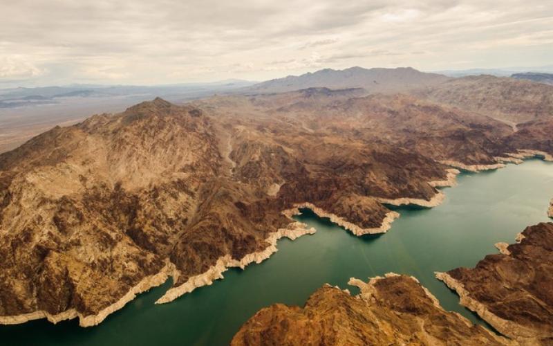
The intense aridity of western states has directed attention to demand for water of the Colorado River, which by 2100 is likely to fall fall 55% and has already so unremittingly declined that what waters pooling in the expansive reservoir of Lake Mead may well no longer be allocated at levels states were accustomed. Powell’s historical map of the drainage basins that he proposed provide a template for the most profitable economic settlement of the region has been seen as a lost opportunity for settling the west along lines respectful of its fragile ecosystem, but the expansive settlement and population of the west were nurtured by images of a false abundance of an infrastructure of a region where low rainfall meant low soil moisture that set unfamiliar standards for aridity, only able to support a different variety of grasses, cacti, and yucca, unable to afford familiar grazing rights and where irrigation would be entirely “dependent on the volume of water carried by the streams,” as he had already argued in 1878, meaning that less than 3% of the public lands open to settlement could ever be cultivated by existing streamflow.
Although the increased aridity in recent years of the same region reflects the far heightened aridity created by global warming, the exponential multiplication of problems of water delivery they stand to trigger stand to return the region to a cyclical aridity from which there is no clear turning back. The difficulty of imagining or viewing the same map by a slider bar lie not only in the huge demand of a multiplication of settlers since in 1922 interstate compact to provide for the “equitable division and apportionment” of the Colorado River System forcibly redirected in one of the largest infrastructural project of the western states, hoping to “remove causes of present and future controversies” that unrestrained settlement of the west had brought. And although the focus on the dramatic decline in the snowpack and flow into Lake Mead over the past two to three decades has provoked a range of time-lapse maps with and without slider bars, often profiting from remote sensing and satellite photographs.
Such maps oddly fail to capture the starvation of the Gulf of California from the impoundment of sediment in the dam in 1933: redirection of the thunderous rush of river-water removed almost all of the river’s flow from any hope of irrigating Mexican territory, effectively and magisterially shifting the flow “more than 100,000 acres of irrigable land not yet irrigated” to the Imperial Valley, seized by the hopes of the irrigable potential of New Mexico and other regions that would be long worked by braceros and migrant laborers who have long picked lettuce, melons, watermelon, tomatoes, peaches, and other winter vegetables and fruits that the appropriation of water rights in 1956 affirmed as western states’ population grew, before the 1963 decision, Arizona v. California reserved some river rights for Mexico, remapping river use as an affair of allocating river-flow within the nation, a legal fiction that set a precedent for confining all the rain fell in the Upper Colorado Basin reallocating of river flow.
13. The map expanded the constraints reduced rainfall placed on future farming operations by its brilliant color and largely innovative seemingly idiosyncratic scheme. In a riotous range of chroma, distinct from most rainfall maps, Powell configured western states and territories to show the racially distinct natures of environmental settings in the sedimentary topography whose rivers and basins he knew well. They seek to resolve the basic dilemma of rainfall discrepancies cutting across the borders of states of the Arid Region placed before viewers of this 1874 rainfall map, even as increased numbers of homesteaders headed west to “public lands” from which indigenous inhabitants were expelled and cleared as the arid lands were newly surveyed.

14. While the romance of Powell with the “blank spaces” of the map have been often recited, it is perhaps in need of revisiting, as the romance of the West. Powell’s love of “blank spaces on the map” were mythologized by Wallace Stegner in our national consciousness, as a form of early environmentalism. For Stegner, the depth of Powell’s “knowledge and experience of the West and his passion for order”–two principles that combined in the maps that manifested both–presented an undervalued “clarifying vision of what the West must do to growth into a strong part of the American commonwealth,” a vision of governmentality–and indeed tactics for government that became a “grand strategy” of land management–that took its bearings from and was rooted in a romance with the land, and the largely unknown upper headwaters of the Colorado that Powell, more than anyone, brought into national consciousness, long after the 1857-58 exploration of the lower Colorado and its delta, which was imagined as a potential outlet to the sea for western settlers in the mid-nineteenth century.
Such a romance, as many geographers have recently noted, was a romance of set a basis, termed ecological, of values of conservation based in conserving resources, and surveyed aridity to question what governmental regime would fill territory not unsettled, but long lived in by indigenous tribes, if cleared by disenfranchisement. Even if Stegner’s claims resonates with recent calls by the Sierra Club’s call to keep “digital blank spaces” as cell phone coverage expands in one-time wilderness. Powell, Stegner imagined, found “on the maps he carried . . great blank spaces,” maps he used to “replace hundreds of square miles of cartographic guesswork with information,” as if it were a valiant effort of heroically combatting “with all his energy the tide of unreasoning, fantasy-drawn settlement and uncontrolled exploitation,” in a “modified Great American Desert,” a vision that denied displacement of indigenous inhabitants implicit in recasting of “Indian Territory” in Edenic terms as open lands ready for settlement.
Is it a surprise that Stegner, as a writer, while not ignoring Mexicans reduces them to flat characters, with whom the readers is expected to have little empathy–and omits or elides an indigenous relation to the land. If Stegner heroized Powell for his ability to see the American west in its integrity–“real and whole”–that he described as fulfilling a desire for better lives in a “geography of hope,” it was scarcely for the indigenous inhabitants save as they were seen by Powell as, in line with the Dawes Act (1887) that had permitted the resurveying of lands long settled by indigenous tribes, and allotted lands to indigenous families, effectively encouraging them to adopt conventions of individual ownership of private property undermining tribal cultures and by after by executive order assigning parts of newly surveyed long-inhabited lands to family heads, to erode communal settlements by resurveyed land allotments, perhaps reserving land “advantageous for agricultural or grazing purposes” as ‘left over’ or ‘surplus’ to be sold on the cheap to non-Indian eager homesteaders for cash. The eventual disbursement of some 90 million acres of resurveyed land by the General Allotment Act consigned some two-thirds of already diminished lands of reservations to non-native ownership.

Powell’s role as the Superintendent of Indian Services, later the Bureau of Indian Affairs, was an activity of active re-bordering of the western lands, transforming “blank spaces” on the maps to sites of private ownership, by a new cartography of private land ownership whose logic undergirds the bracketing out of lands beyond those borders. Is it a coincidence that the involvement of Powell’s involvement in American Indian Services, ancestor of the Bureau of Indian Affairs, that led the Dept. of Interior to flood indigenous land for water reservoirs up to forty acres across the American West, converting If the US Supreme Court has recognized the rights to possession of tribal lands dating to the early 1800s, including hunting and fishing rights on lands seized in the early twentieth century, most of which have been since converted to the very reservoirs that Californians today draw their water supplies.
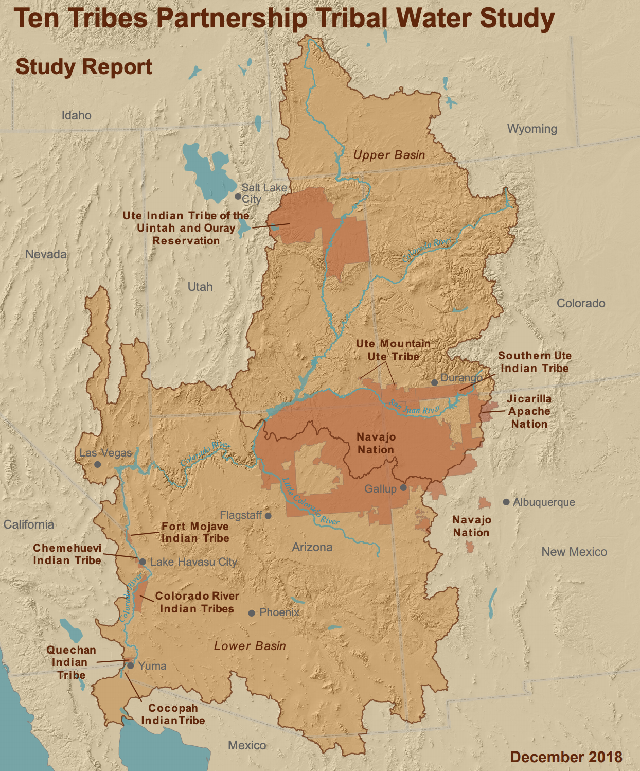
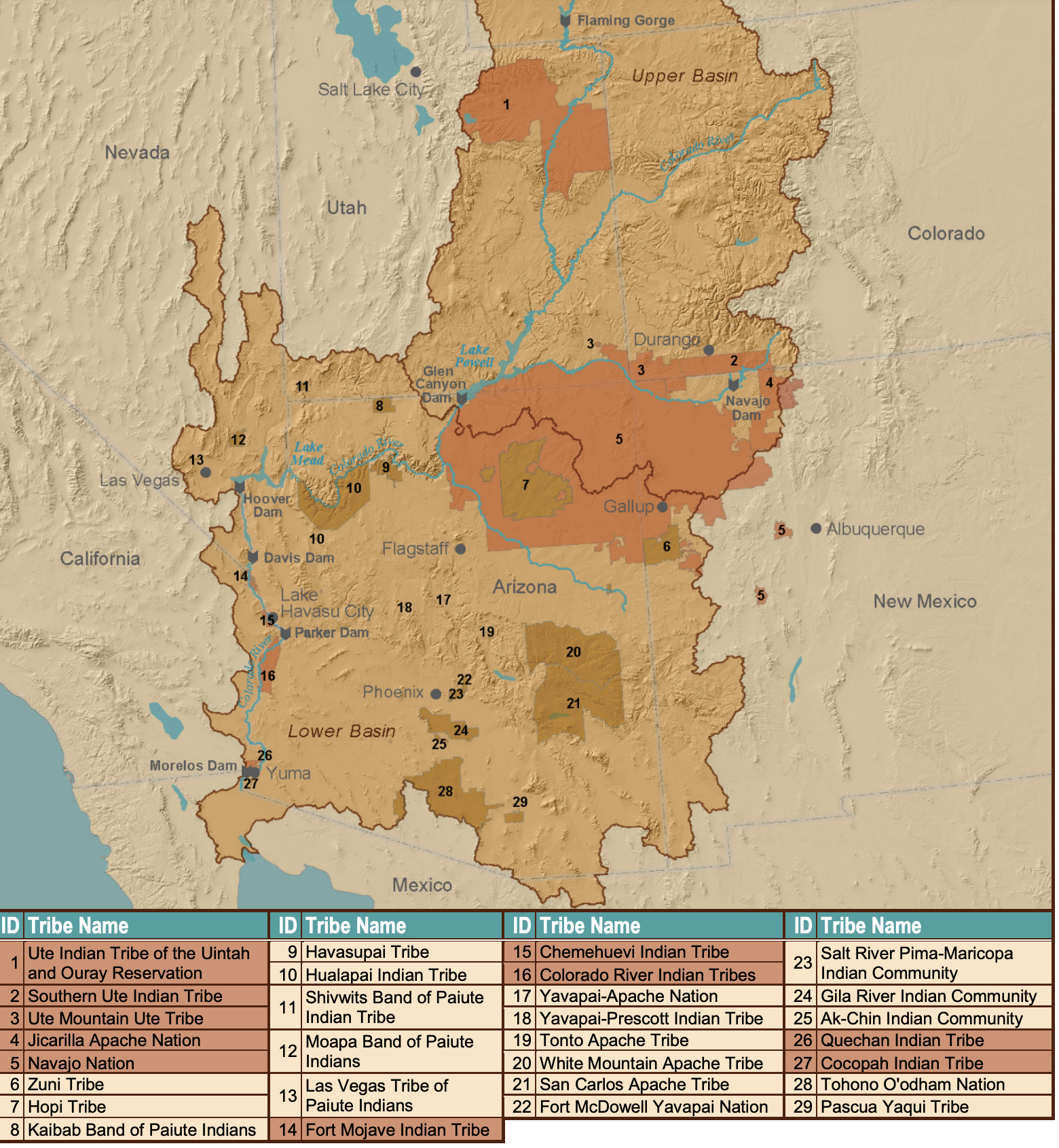
Powell bemoaned the relative ignorance of Washington in presuming to have accurate maps of the region at its command, trusting maps “that put down only what is absolutely, scientifically known, [but] leave a blank space of three hundred to five hundred miles long, and one hundred to two hundred miles broad,” as evidence of the nation’s ignorance of itself: but if cartographers had, in Stegner’s telling, marked the hinterlands “unexplored” in a tantalizing fashion for Powell, as he found maps of the General Land Office tantalizingly blank along the Colorado and Green rivers, in the five hundred and fifty miles south of Salt Lake City from the Uinta Valley to the Little Colorado, they have since been mapped as settled by indigenous tribes, from the Ute Tribe, now inhabiting the Uinta Reservation, to the Navajo Nation, and Chemehuevi to the south: if a map of reservoirs in the state of California is a map of stolen indigenous lands, all the dams built on the Colorado River rom 1923-63 were flooding indigenous lands, from the Owens Valley which flooded Paiute and Shoshone lands, removing water rights with the Bureau of Indian Affairs.
Although Powell has been, since Stenger’s work, identified with the conservation movement, Powell openly aimed to “conserve the public domains” land “to protect for posterity and the public good watersheds and dam sites and playgrounds.” The bridging of two notions of conservation elided the notion of conservation and damming projects by the rational filter of the surveyed map, and erased the broad consensus for dispossession that underlay Powell’s efforts, and led him to be named the Superintendent of the Bureau of Indian Affairs, by which he was hired in 1873, quickly completing of a first report on indigenous living in Utah, Idaho, northern Arizona, Nevada, and southeast California. The future posters addressing “immigrants to Indian territory” to claim the lands declared “opened for settlement” guaranteed “plenty of water and wood on the route,” in an alleged “reopening” of space which Powell supervised. Did his own mapping not implicitly promote a rhetoric of the bounty of land newly open for settlement in such “blank” spaces, as much as a basis for conservation of resources that we would emulate today?
It is in this context that we must consider, no doubt, the intense richness of the coloration of watersheds by the quality of their future settlement, and ask questions about the engineering of the expansion of settlement and development across western states, that has continued to proceed full speed ahead during the background static of continued denial of the contributions of humans to climate change. As we know look out at areas whose aridity reveals the need to re-consider the infrastructure of water irrigation in an area where constraints on development are impossible to deny, Powell’s map provides a compelling intervention in the settlement of the west that speaks to the problem of vulnerability to the absence of water across the west, as if its cautionary mapping of western basins was not heeded. The project of “exploration” that Powell narrated in his multiple pieces written for magazines presented an image that stood for a collective project of “exploration” of lands, an abundance of territories that were not “blank” at all, but were presented as ready for economic improvement and free for the taking, articulating a new geography of desire.


The map was not one of expropriation of resources, but of re-imagining the “blank region” of the 1870 “Rain Chart” of the United States prepared by Francis Amasa Walker for his Statistical Atlas as a habitable area. If pronounced lack of water raised posed questions of settlement, one cartographic solution was to attend to the different soil quality and irrigational practices by which By asking future settlement of the region to respect the varied scale of drainage basins, Powell understood place and space on a different scale of access to potential irrigation and future soil moisture as guideposts of good government of the future administration of the west, by framing boundaries for expansion he believed where rivers might allow homesteaders’ settlement. Powell is cast as something of a prophet of water shortages and hero of land-use reform, respectful of constraints cast as endemic to the region, in light of the disputes of water-usage and shortages of long-presumed abundance by damming and diversion, that have so boosted the settlement and valuation of western lands along the Colorado River and often distant from its course. The central artery of the Colorado River was foregrounded in General Land Office maps of the state abutting “Indian Territory” by 1879, suggesting the hopes for future settlement that Powell had attempted to persuade the government to act to tamp. But the settlement of townships and drainage basins along set county lines made the problem difficult to define by redrawing maps of administration, or superimposing government agencies of water administration atop the boundary lines that parsed settlement on the plateaux and mesa, or the basins and ranges along whose rivers railroads already ran.


The irrigation projects encouraged in the name of reclamation reconfigured the Arid Region whose limited access to water John Wesley Powell had mapped with care by the visual shorthand of seven chroma in 1878 as a basis for future settlement might be measured against the lack of drought contingency plans or strategy before the lowering water-level of Lake Mead, the largest of the several dammed reservoirs of the Colorado’s waters that help redirect to “protect water supplies for the 40 million people in the United States and Mexico” who rely on it for water supply–as if they were stakeholders in its flow, even if they do not live along its shores. The National Weather Services gave us a wake-up call for the limits of sustaining ignorance of the depletion of these very drainage districts. The arrival of excessive heat in an age of extreme climate, placed most basis in extreme territory in mid-July, 2021, as the results of a diminished snowpack and absent rainfall erased differences among “basins” of the semi-arid region Powell monitorally mapped, after many travels and explorative surveys, of so distinct vegetation, temperatures, and rainfall level to allow limited settlement–and only in ways that would respecting the constraints its basins allowed.
14. The trust that Powell placed in his maps stand in sharp contrast to the “purple” coloration of regions of extreme heat introduced across western states to suggest so many “red-flag” warnings of excessive heat. In a year already tied with 2017 for receiving “excessive heat” warnings from the National Weather Service, already in early summer at a rate that is increasingly alarming, purple designates the need for caution when leaving air-conditioned environments, and suggests the booming of electric cooling across the west: the metric of a prediction of temperatures reaching 105°F for a two-hour stretch has paralleled the debate in Washington on infrastructure spending that suggest a similar disconnect that Powell confronted when he tried to describe the need for constraints on planning settlement west of the hundredth meridian in 1890.
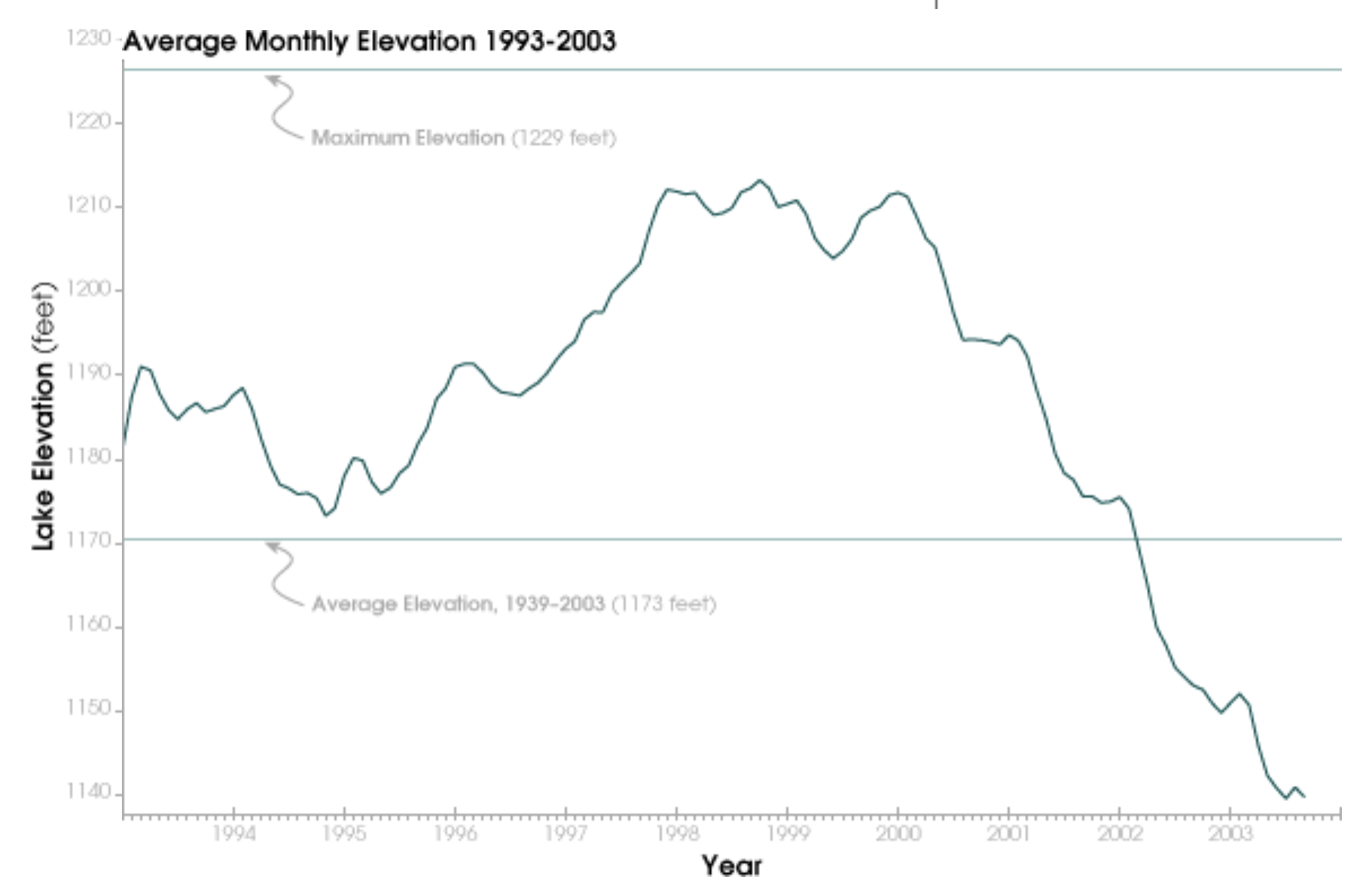
Already during the decade before 2003, the water-level of Lake Mead had declined precipitously, if not far more precipitously than the two earlier declines in its water-levels from the mid-1950’s and mid-1960’s. The decline continued as a plunge below average lake elevation of 1173 feet, by about 2003, in ways that should have sent alarms across the west, were we not consumed by a war against terror, and the attack on global warming by the Bush administration grew, questioning the science of global warming and the dangers of increasing aridity.
Four Excessive Heat Warnings issued from late May 2021 have introduced yet a new color to prominence in National Weather Service maps, the new deep purple was introduced in weather maps in 1997 as a venture of the NWS into health alerts; rarely used in other weather maps, which in recent years have shifted from urban areas to large stretches of the nation, shifting from a use of red to designate high temperatures to purple to designate risk of triple-digit temperatures, especially in man-made surfaces like asphalt (able to rise to 170°-180° Fahrenheit–territory of third-degree burns–or cars which can rise thirty degrees above air temperature.
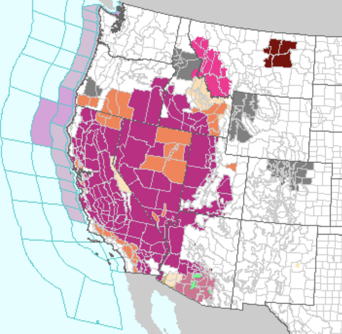

We have come so far from drainage basis in an area of excessive heat that the lack of soil moisture and low level of water that reaches rivers may consign the irrigation schemes tied to the interstate compacts of the Hoover Dam to the dustbin of history. Can the very fact of lack of proximity serve to mask the ignorance of the scope of the declining water-flow from the very upper drainage basin of the Colorado, from which the river draws an estimated 90% of its flow. Has the magic trick of reallocation inherited in the interstate compact promoted a geography of ignorance, by recasting water rights as a “right”–in a misguided belief this would make states stake holders, even while promoting a false story of inexhaustible bounty of water flow? While Powell rhapsodized the manner that the Colorado River, which he explored as it ran through the Grand Canyon and canyonlands, as running south to empty its contents “as turbid flows into the Gulf of California” in 1895, now no longer runs to the sea. The expansion of regional “excessive heat warnings” suggest local weather systems driven by fires pushing northwest as a region into new chromatic registers of triple-digit levels of heat.
How can we tell the story of the lack of water across the west, and the drying out of what was mapped a century ago as an arid zone? After sustained engineering of a geography of ignorance about climate change, supported by sustained denial as to whether this was an “open” question still waiting for certain confirmation by science, as a tactic of public stalling of the American government demanding “more research” to be confirmed, that has in fact overturned scientific consensus that “most of the warming observed over the past fifty years is attributable to human activities,” as well as the amplification of climate change with the absence of a reflecting of solar radiation by ice-cover at the poles and at high altitudes in the snowpack, an amplification of climate change accompanied by a rise in extreme weather, from hurricane intensity across warming oceans to flooding.
Yet the political polarization around climate change even as global accords confirmed the danger of burning fossil fuels and releasing greenhouse gasses, was received and recast in ideological terms as a debate–and widely retweeted fictions that theories of climate change originate in a fictional scheme of foreign countries against American productivity–even as climate changes were discerned. False polarities between “ecological terrorism” and “environmental radicals” and an open and unregulated market on land-use cast the “natural” metrics of economic health against outrageous demands that seemed to have their origins in rigidly inflexible ideologies, not science, planting danger signs clouding of “good” scientific practices with political agendas.
The geography of ignorance gained new textures by the transposition of the lived landscape and experience of rising temperatures into a suspect agenda of radicals, either charged for arson or for “spiking” trees to prevent logging companies’ commercial advance. Yet for all the demonization of radicals spiking trees, the logging companies themselves encouraged the dense growth of trees.

Before such a ravaging picture of fires from underbrush, should one not mention that the long history of prohibiting established indigenous land management techniques of fire containment? Suppressing indigenous prescribed burns in California forests–part of a global story of replacing traditional tools of containing and mitigating fires in wildlands worldwide by states–has prohibited prescribed fires for a century. US Forest Service outright prevented land management practices of removing dried brush for corps trained to “fighting” fires; USFS prohibited prescribed burning outright from 1921 in favor of “total fire suppression.” Such a mandate for prohibiting indigenous prescribed burns altered the landscape; although indigenous people had been removed from most forested lands in California and other western states from the late nineteenth century, lowering fuel loads and managing oak woodlands. Elders of the Tsilhqot’in nation in British Columbia still describe fire as a process of “lightening the load of the land,” according to Elders, or burning dead grass; “cultural burning” occurred in response to the ecosystem, but in BC was prohibited in 1874 and ten years later on a national level, as part of Canadian attempts to assimilate indigenous peoples, coercing tribal nations not to burn to protect lumber supplies was the norm in the northwest; only after a century of of fire suppression were Yurok and Karok fire management techniques adopted to tribal and federal lands to mitigate increasing wildfires, after the thick fuel loads of western forests inaugurated an age of megafires, igniting more rapidly, spreading more uncontrollably, and greater unpredictably in fires’ spread. While increased aridity creates heightened danger of fire from underbrush and large fuel loads, regular thinning of forests and undergrowth limits invasive species and allows aquifer recharge, by reducing forests’ overall water consumption.

