
15. Charges that demonized climate change dynamics as based on uncertain evidence were rooted in questioning of climate change think-tanks who in the 1990s aimed to question expertise and consensus in a bid to recast climate change as a “perversion” of science that continued concerted support of space-war strategies sponsored by the Department of Defense that scientists had questioned, and tried to steer public opinion. The shift from promotion governmental priorities in defense continued in the questioning of governmental organizations as the U.S. Global Climate Research Program whose objectivity in accurately measuring warming as climate change, by questioning its idealogical agenda basis; ending limits of emissions fit agendas of extractive industries and big business, hand and glove, encouraging the dislodging of warming from measurement, good science, or practices of observation.
Limits on emissions and fossil fuels were widely re-presented in purely economic terms; the EPA advisors of the Bush administration were increasingly representative of industries bent on avoiding government regulatory systems and environmental restrictions, feared to be placed on the table in a feared administration of Al Gore; environmental lawyers populating the EPA were not only saturated it with members of the petroleum industry, but from the timber company, agribusiness, chemical companies and wheat growers who defended practices of burning fields without emissions safeguards on run-off or particulate mate, industry-driven and primed to reshape regulations to market-driven solutions; for Dept. of Interior, Bush tapped Gale Norton, former AG of Colorado, to advance offshore oil and gas drilling in the western states that allowed to the Deepwater Horizon disaster–as the EPA combatted eco-disasters from the Chevron Spill to Exxon Valdez. Did fines assessed Exxon, Chevron, and others run a smoke-screen against environmental change, as the RNC was flooded with funds from energy interests in the oil and gas industries invested in Republican candidates? If they were interested in tamping down regulations and fears of global warming, “global warming” was only demonized as a symptom of a globalist agenda in the 2016 election, embodied by Hillary Clinton of American ideals, as NAFTA, global treaties, or failure to protect U.S. diplomat Christopher Shay in Benghazi, in a masterpiece of sloppy lumping typical of the increasingly illogical guilt-by association amplified on social media. Donald Trump became a spokesperson for the “hoax” of global warming that was spun as against American economic interests and America’s dominant position in a global economy.
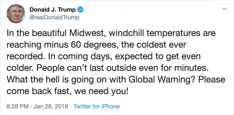
Charges that global warming was not the work of expertise but “hoaxsters” grew on social media ecosystems, from 2011 denouncements of the “manipulation of data on global warming” that was cast in increasingly ideological terms as a “canard” promoted by “the left” by 2012. The result recast global warming as a “false war” that consumed the American budget to create deficits, and hurting the nation and national interests–and, by 2012, distract attention from a War on Terror. Global Warming was a tag for “faulty science,” Donald Trump urged, a “hoax” perpetrated by elites that only hurt American economic manufacturing and made the nation anti-competitive–in a drum-beat of skepticism at a rigged system that prepared for his political ambitions as a new truth-teller. The accusation that the very term “climate change” was not scientific, but a cover for the lack of response to “global warming” as a failed brand worked as a sound-bite on social media and one that distorted one’s orientation to the environment.
The opposition between economic competitiveness and global warming created a polarity that undermined science, by removing the threat of climate change from national interests. Networks picked up how science communicators in think thanks questioned consensus on global warming to treat its discussion as meriting “equal time,” during George W. Bush’s presidency, as the think tanks worked to stall emissions reductions, casting restrictions on fossil fuel burning and fracking as economic constraints imposed by “big government” to demand American sacrifices for a global problem, while allowing other nations to burn fossil fuels. Revisionary views of ozone depletion, and questioning of climate science, buried in the agenda of protecting national interests above international binding targets, redrew the map of climate change in radical ways, based often on news reports and public statements rather than refereed journal articles or measurement. Based on rejiggering mathematical models to argue that fears for climate change were in fact over-exaggerations of pseudo-science, the skeptical dismantling of monitory signs of escalating temperatures and cyclic climate change became license for the return of a free market economy that lifted all government curbs of fossil fuels as “market-killing” propositions.
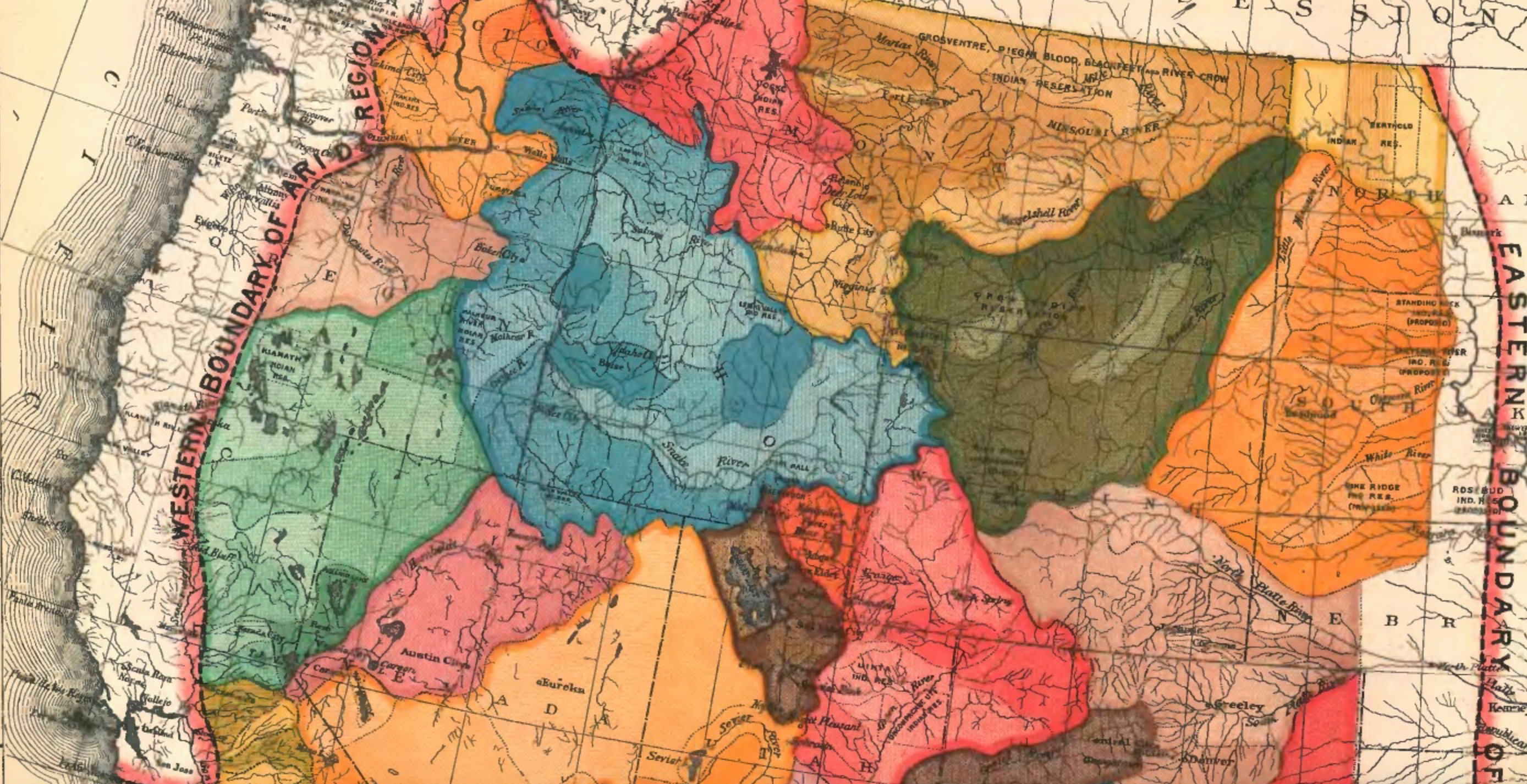
16. Yet perhaps the return to the tallying of mortality rates in scenarios of anthropogenic global warming seemed more immediate and pressing, perhaps, than the simple rise of temperatures, if one considers the cascading effects of intense heat, beyond the impact of “extreme heat” events on human well-being to the residents of those states-and indeed the disruption of man-made infrastructure that enabled the expansion of the west. What is a map, but a public tally of accurate measure? Only by imposing a geography of ignorance atop established consensus of a geography of the “arid region” and privileging a free market for water rights could one challenge the hope of prioritizing conservation across the western states. If Powell’s map suggest the inevitability of surface conflicts that would result from the difficulty of water diversion schemes, and a more conservative model of water diversion of the water-flow of existing rivers. If we might see Powell as imposing a new lines of jurisdiction of local water boards atop state lines, the current contours of a geography of ignorance place premium on local “rights” to water atop constraints, resisting regulation of water as depriving liberty of consumption, as if they have no relation to the global issues of decreased rainfall across the west and world. Only by casting global warming as not science, but a “hoax” perpetrated on the American people, erased the memory of an Arid Region Powell rooted in a map of water-rights and settlement possibilities in western basins. Powell’s map condensed huge effort of quantification to envision the western states as grounds to justify a robust ethic of sustainability after a decade spent mapping, classifying, and studying the Colorado Plateau that culminated in his 1878 report. Powell’s vision, at odds with the promoters of real estate who encouraged homesteaders eagerly proceeding west into what inviting territories, was rejected.
The hydrographic framework of diverting the Colorado centered at the Hoover Dam created a network of irrigated lands, and electricity that river water would generate, is threatened to have reached an end, it makes sense to ask how the multiplying stresses of global warming can be internalized, and recognized. Powell hoped the map might ask legislators to justify the existing division of territories–underlying the jigsaw puzzles of drainage district–as if question the feasibility of imposing administrative entities across basins; the division of underlying civil authorities of Idaho, Wyoming, Utah, Nevada, Arizona, and New Mexico–all noted in capital letters–are queried as the best means to administer discreet watersheds, often aligned, but at times incongruously unaligned with river basins along the serpentine Colorado that Powell argued offered the only viable or rational units for future settlement.

The map can be read as a dialogue about borders and bordering–and is increasingly easy to read it as such.

But the colors that fill in the blank areas with a level of detail fittingly recalls the colors of the 1874 geological survey of the Statistical Atlas; they suggest a fault line that has not only defined a new sense of the logic of the region’s settlement, but what has been long seen as a fault-line across the western states in what has been called the “psychogeography” of the nation–to use a term that situationalist Guy Debord coined in 1955 to invite exploration of the ways place shapes human behavior but has gained broad use by artists whose working practices employ GPS. The hundredth meridian has been described, echoing the material practice in which Powell’s map was produced, as having “etched into the nation’s collective psychogeography” by Seager, et al., as a line of potential agrarian cultivation, defined, for Powell and later geographers, by the unique air currents and atmospheric circulation, defined by its effective remove from the Atlantic or Pacific seaboard that defined its extreme aridity, evident in a transition of plants from luxuriant prairie grasses to cacti, the “sharp bayonets” of yucca, and “subhumid lands” as air moisture, released in snowfall over the Rocky Mountains, has been so drained of water that the territory demands different strategies of irrigation. The sense of an ecological limit, demanding, as Precott Webb argued in 1931, whose distinct hydrology demanded development of new methods of agriculture, was framed after the 1928 interstate compact as a technological problem of settlement akin to a foreign land.
The sharp dissonance between the often earthen colors of basins and the impositions of doted lines of states that followed meridians placed the ball in the court of the viewer of the map. The regions that Powell colored so richly in shades of blue, green, tan, ochre and brown area easily read to day to suggest a repressed integrity of richly earth-colored basins, whose coloration recalls nothing so much as distinct soils, their shading corresponding only partly to the density of the skeins of rivers in a watershed; unlike the absences of rainfall in blank spaces of the “Rain Chart” that left the region with few features in the 1870 Statistical Atlas that was its clearest precedent, as an basin beside wetter areas inhabited by indigenous peoples, in territories with far greater rainfall.
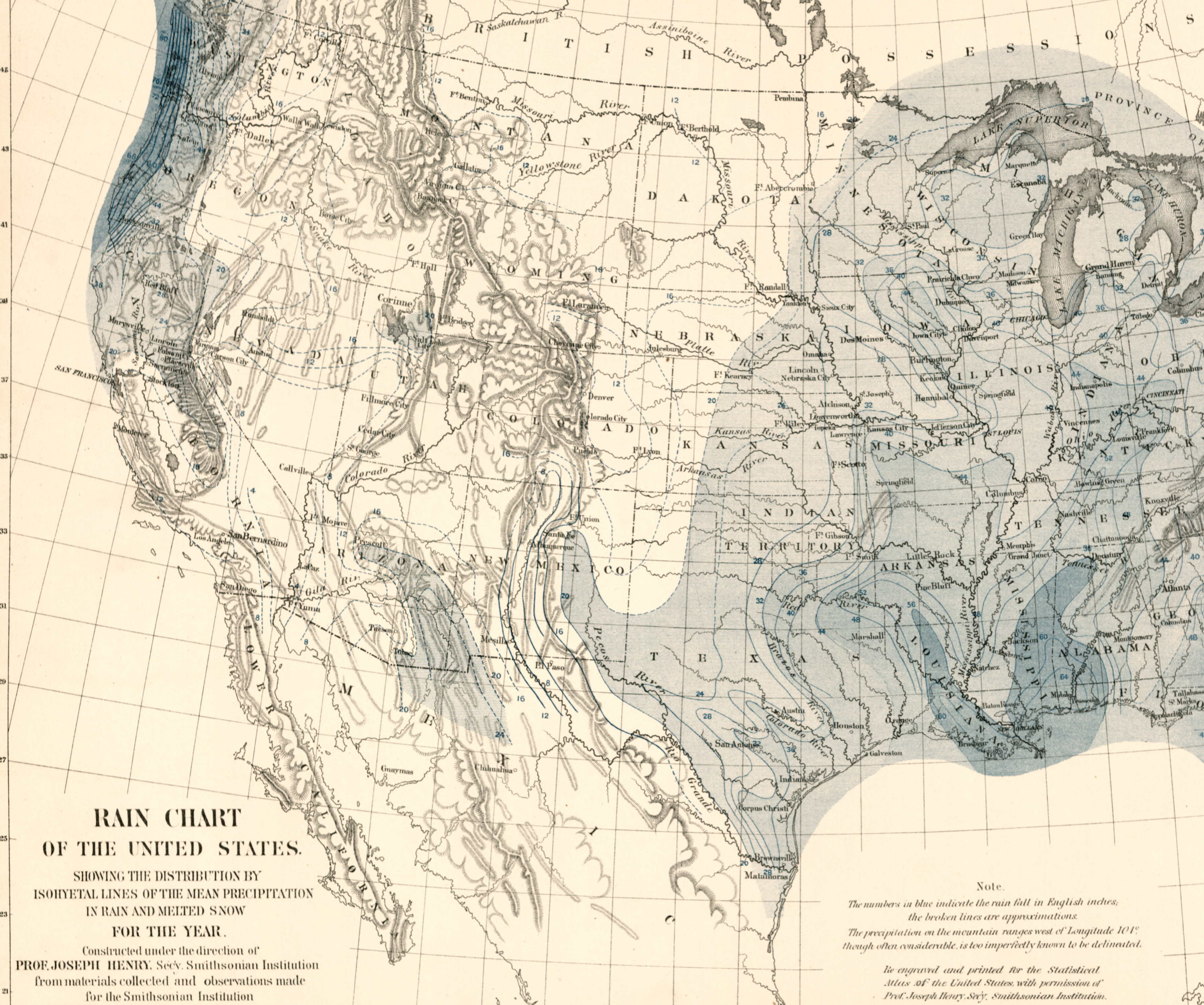
the detailed rainfall chart of the 1870s Statistical Atlas showed the region as blank, in the rainfall map of western states, the “great blank space” to which jurisdiction over the area was imagined. Was the blankness of the map an invitation itself? The surveyor Powell was said to be attracted in the Colorado Plateau was recast as one of settlement–what Preston James has portrayed as Powell’s “insatiable curiosity about the blank spaces on maps, and about the ways of living of the inhabitants of those areas,” and Wallace Stegner to fill in those “great blank spaces” on his maps. After Walker’s distinct coloring reserved for river systems, woodlands, and geological regions, Powell used distinctively diverse colors and shading to indicate the variable land use and distinct forms of land management that would incorporate technical knowledge of the land’s quality for development the great aridity of the region demanded, arguing its settlement would be achieved by respecting distinct drainage basins–the only rational basis for future settlement of a region climate whose alternative, Powell caustically warned in 1883, lest the landscape be immersed in inevitable legal conflicts endemic to “a heritage of conflict and litigation over water rights, for there is not sufficient water to supply the land.”

But Powell’s focus on the lands of the arid region, rather than their By redesigning the administration of water rights not to “states” but along the lines of watersheds, Powell saw an avenue for governing natural resources and precepts for water conservation that might prevent what he saw as inevitable disputes as to water rights, and would have registered a rebuttal to reliance on existing maps of territories–which the senators of Nevada resisted, and just before Idaho (1890), Wyoming (1890), and Utah (1896) were recognized, and long before New Mexico (1912) and just after Montana (1889) was. If several of these states entered into the inter-state compact that led to the irrigation projects of the Hoover Dam, the result was not cartographic revisionism, but a return to the earthen ochres, tans, orange, red, yellow and brown to suggest that the government was confronting not with a blank slate but one that took cognizance of criteria of land-use that included irrigation systems.
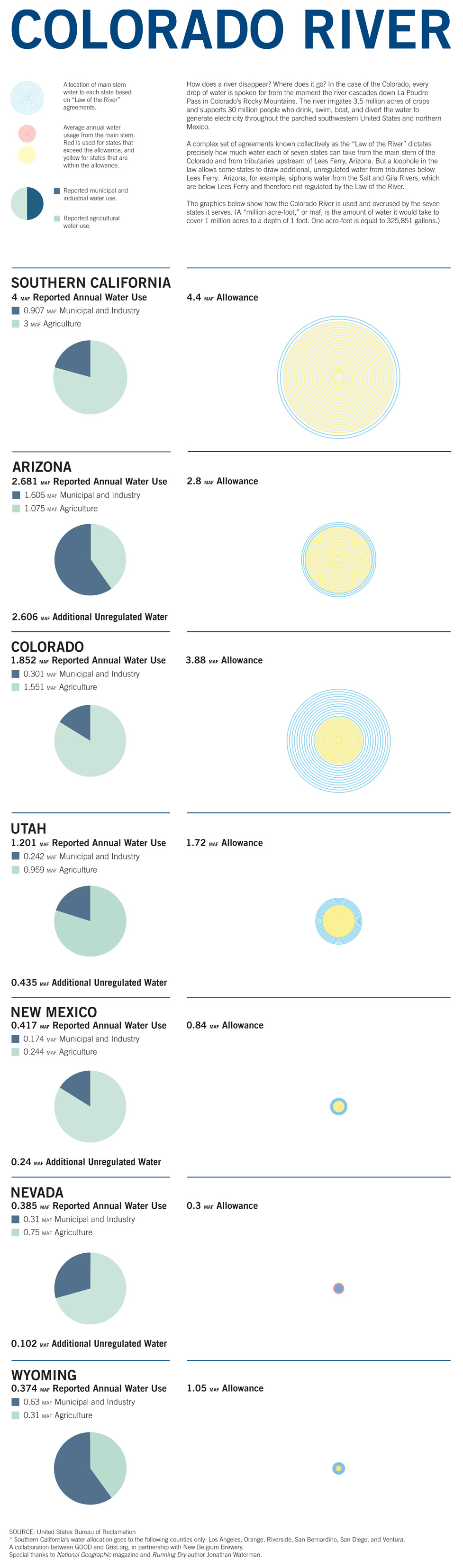
The historical amplification of subsequent projects of water diversion and syphoning for increased irrigation canals diverted the waters of the Colorado River subsequent to the Hoover Dam on steroids, a work-around over Powell’s intentionally rebarbative map, that makes us look back at the map as if its earthiness suggest an environmental vision of a road not taken, whose hydrological detail offered a lost world of. The careful chroma that distinguished watersheds as entities were hardly cartographic revisionism, but reset borders of the largely unsettled and un-administered land to bring them into a new form of governmental control or governmentality, creating the relation of the state to the land within the boundaries of the map. If it is tempting to oppose the map to the logic of the free market and Manifest Destiny, it suggested the basis for water diversion in western regions–and indeed presented the “problem” of the lack of rainfall and moisture–as the grounds to organize the region by a logic of its irrigation, setting the logic frame of reference for water diversion projects that came to feed 3.5 million acres of agriculture. The scheme of water diversion and canalization that under-wrote big agra and agrarian farming, more than local farmers, expanded the logic of government Powell used to configure the west as the “Law of the River,” or inter-state agreements of water-sharing used to justify diversion of three million acre-feet to Southern California, part of Powell’s “Arid Region,” over a million acre-feet in Arizona, three quarters of a million acre feet flowing to fields in Nevada and over a million and a half acre feet to Colorado in agriculture alone.
The absence of good government in providing water supplies make us look wistfully back to Powell’s map as the evidence of an early environmentalism in allocating water supplies, perhaps undercutting its own governmental claims. The mapping of the “arid region” created a territory that demanded intensive irrigation, systematization, and domesticated the exploratory travels Powell had described or mythologized in written newspaper articles on the Green and Colorado Rivers by the unprecedented technology of redirecting the rivers’ flow to other states, domesticating the waters of the river that he had explored in order to bring “open” lands into governmental administration–a way of seeing the once “open” spaces of the unsettled west like a state or state agency. Even if his recommendations for hewing to the basins as a template for water diversion were not followed, the very project of “domesticating” the region that he had outlined in the 1878 report on the “Arid Region” in terms of “the engineering problems involved in their redemption”–without having need to expropriate land or work from irrigation companies, “coding” lands most adaptable to irrigation in a bright green, lands to be used for lumber brown, regions with burnt timber red, and areas of mining a different color–classifying the western lands by land use, optimizing natural resources. As Powell had advocated indigenous tribes be removed from areas rich in timber, the land-use system was a way of defining the use superior civilizations could make of the region, in contrast to the indigenous tribes for whom all religion and understanding of the land was localized: the map provided a basis to expand the settlement of the land by the “civilized” settlers who would take their place to exploit its natural “resources” in full.
The market was not able to divide the land by a system of capitalist ownership, but by planning of their exploitation and understanding their true value. These states are withdrawing water from the river either at the limits of their “allowance” per “Law of the River,” that is no longer about one river, but augmented by water syphoned off in northern Arizona just below Lees Ferry, AZ–the start of Lake Mead’s reservoir, where it is still not covered by the interstate agreements–or are exceeding that allowance, in the case of Nevada–and exceeding the river water allocated by the agreement. No wonder the river now hardly reaches the Gulf of California, diverted as it is in ingenious ways to remain north of the border, in a conceit of “conservation” that relates to overgenerous concepts of “water-use.” As if underlying this geography of ignorance that allows water to be diverted, extracted, and syphoned from the river, Powell adapted the chroma of an intentionally jarringly colorful map of parched lands to instill ideals of land stewardship by conserving resources, parsing areas of sufficient water supplies to be apportioned to homesteaders to urge Washington senators to internalize the ethics of its administration.
The ambitious hydrographic survey of the western states created for the fledgling United States Geographic Services aimed to preserve the drainage regions as a national good that later schemes of water diversion undermined; platforms of “land reclamation” c. 1900 fractured the unity of basins by engineering canals of water transport, redefining a water usage and water rights as proprietary goods, diverting the river’s water across a compact of western states. While Powell’s was a map based on detailed familiarity with plants and vegetation that rainfall in the region allowed, the distribution of the river’s water suggested a new geography of national benefit, that replaced actual rainfall with a sense of water budgets, and redistributed by irrigation projects.
With the increased aridity of global warming lowering the levels of Lake Mead, the system of diversion may have reached its end. Pynchon suggested we take stock of how ignorance has its own map, whose contours, scope and textures and rules of operation we are most content to remain unaware, bracketed off from day-to-day consciousness, massive irrigation projects encouraged by what became the Bureau of Land Management reconfigured the terrain of the Arid Region that was once mapped with care by John Wesley Powell by the visual shorthand of seven to fourteen chroma in 1890 to expand a geography of ignorance an absence of care, removed from a familiarity with rivers, based on subsistence agriculture. Yet the drainage of the Colorado’s waters that have irrigated agribusinesses from the Imperial Valley to Arizona to New Mexico have created a booming economy of farming, erasing the constraints of the local landscapes that Powell described. The failure to adequately map the extent of water distribution of river flow damming enabled recast the compact that the language of “entitlement” against evidence reconcile with the longterm circumstances of drought, erasing the anthropogenic nature of water redistribution by foregrounding the riverine network, and eight major dams as parts of a national landscape, omitting their impact on the river running only to the US-Mexico border.
Although all dams are anthropogenic creations to store water and divert water-flow, engineers regularly bracket or selectively omit suggest the stoppage of the sediment in rivers. Yet dams on the Colorado cumulatively decrease the capacity of water storage of a reservoir, filling–in the case of Glen Canyon Reservoir–annually filling 100 million tons of sediment–to relieve aggradation of sediment arriving in Lake Mead, often storing toxic runoff chemicals, from arsenic, mercury, and yellow cake uranium from mining. The demand for water management–or reclamation–relies on a logic of diversion, whose blockage and reduction set a precedent for engineering river-flow in national terms, but expanded the ignorance of the impact of stoppage on the nation–and indeed the temporality of damming as a project, aiming to ensure the viability of the damming of the Colorado River’s waters at Lake Mead for at least four centuries–and later to a potential thousand years, lest the huge basin of the Lake be entirely filled with silt, sand, and other sediment born south in the river’s flow.
The comparison between the national mega project based on the interstate compact to the Border Wall suggested to me the value of drafting a map contrasting the extent of blocked sediment in the Colorado River with the extent of construction in 2019 of the Border Wall. If the waters of the Colorado River were long mapped by government agencies USGS and the Bureau of Land Reclamation as ling north of the border, the adjudication of its diversion between Lake Mead and the Imperial Dam near where the border wall runs though Yuma AZ stopped at the same border that effectively enclosed the allocation of water from the River, and starved the river so that it ends several miles before reaching the sea, so dramatically has demand for its water outstripped the supply of water from its upper watershed for decades.
Moving in parched auburn landscapes in northern California, where temperatures regularly rise into the high nineties or hundreds, prompt questions of their sustainability, the increased crispness of grass underfoot is an odd contrast to the water that local vineyards seem set to receive for now, but to cross their fingers they will be able to still receive, uncertain of the possibility of water distribution, as irrigation seems a dream of the different country of the past. Looking at the low levels of western rivers, accentuated by spreading fires, low soil moisture, heat domes, and fires whose heat directs weather systems, the rivers have become so alienated from the landscape that it is hard to see them not as being erased by anthropogenic change. While he championed a model of irrigation of soil, it is hard to not view Powell’s work both with melancholy and commands renewed attention as a model of sustainability, but also as a basis for trying to engage audiences with ideals of sustainability. The problems of decreased snowpack, increased evapotranspiration along the river, and lower rainfall and lower soil moisture in the Upper Basin watershed have created an endemic shortage of water in the river’s flow. Despite increased attention to local variation in streamflow in parts of the watershed, formally and stylistically echoing Powell’s attention to drainage basins by local sampling stations, the river’s flow is largely understood by thresholds of apportionment in both basin.

Would it be possible to disengage the Colorado River from a massive network of water diversion, and to present the effects of dam-building on the river that is now so strained and diverted it no longer reaches the sea?
Despite the sharpening dangers of the western drought whose scale was mapped since 2015, the national emergency of the falling water levels of BLM reservoirs and of soil moisture across the west was a topography that somewhat strategically expanded to a greater geography of ignorance as the southwestern border was described as the site of national emergency to justify construction of Border Wall to protect the nation.

