
6. The distinctly vivid nature of Smith’s chromatic spectra revealed variations of sediment that expand the authority of the map, and indeed the authority of the map as charting a foundation for future economic growth, in ways that offered a powerful graphic precedent for Powell’s own keen sense of the relation of sediment to national wealth based on his familiarity with a geological record, and the ways rainfall-levels take precedence to sedimentary geography, using his own map to correct what many state geologists affirmed about the possibility to remediate grounds that have continued to play such an outsized role in the western states’ mythic geography: the ways Smith asked readers of his map to attend to the variations in sediment that drove the national economy proposed to better understand the national economy and land-use from mining to farming, a key to promote national economic health: a friend of James Watt and other inventors, Smith offered lenses to reveal a hidden logic of economic betterment.

Smith’s geological map of strata began from small-scale surveys of the region of Bath from 1799, preparing a national geological map by 1815 that parsed a national economy or wealth by his own expertise of geological observation and surveying–the accuracy of the map indeed holds up with contemporary remote observation tools. The parsing of western lands by Powell followed his expertise in geology, a field that emerged from Smith’s surveys of strata, not only to map veins of coal, but determine agriculturally profitable regions and locations, distinguishing different soil types and their overlaps of thirty-four vivid colors, distinguishing geological layers of public value for landowners and surveyors, and its expensively hand-colored atlas condensed extensive surveys over fifteen years; as the only geological map of its sort set in twenty years the basis for the first national geological survey of Britain, but a model of geological mapping of a historical record, to attract the eye of his subscribers and pose in visual terms the problem of the relations of individual strata of different rock types. Printed at considerable cost after the Napoleonic wars, the map celebrates as well as a delineates strata through geological cross-sections of the nation.

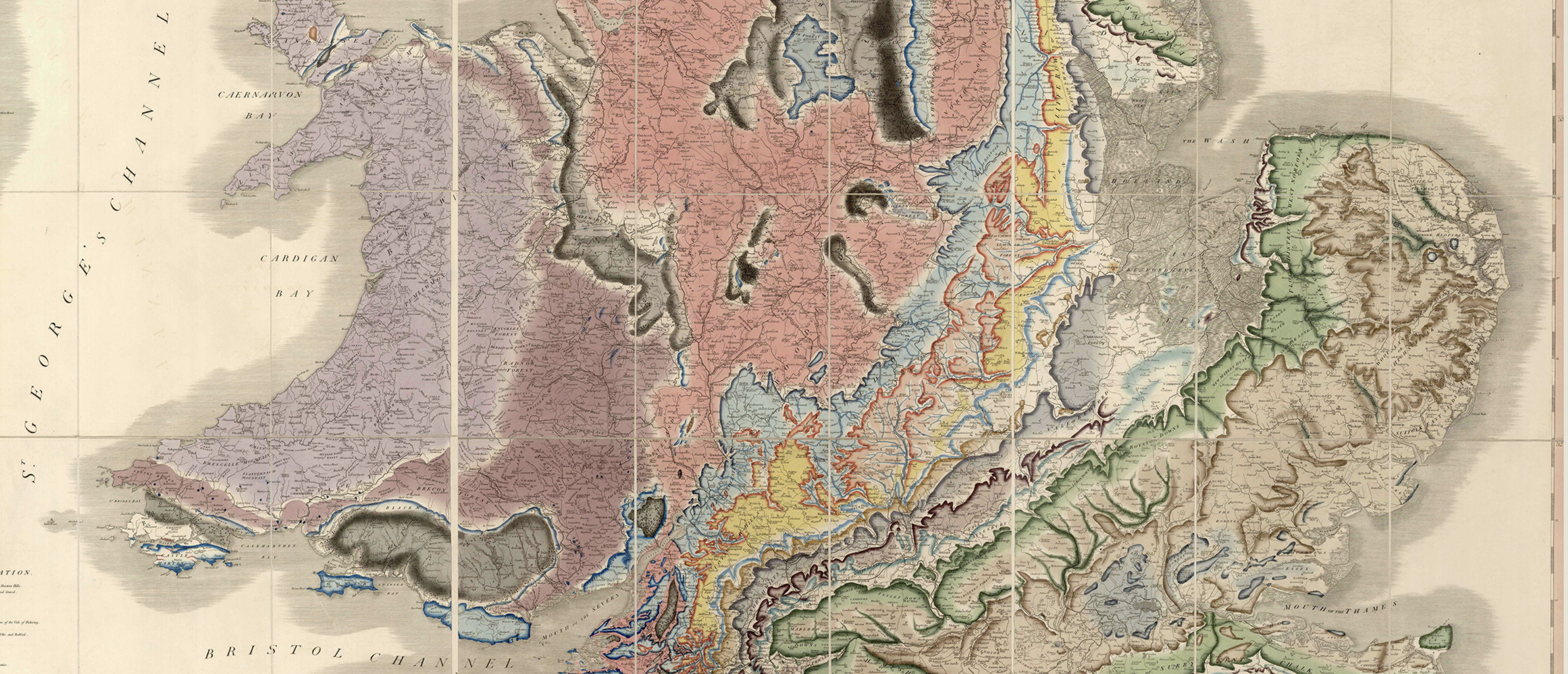
A geologist by training, Powell navigated in wooden boats down the Colorado attuned to the dangers sandstone and limestone presnt, attentive to entering older and deeper dangerous regions of hard granite and schist that seemed to tell the “story of creation,” descending into the rock formations in the New World, as the strata depicted by William “Strata” Smith in the thirty-four hand-colored tints in geological maps of England of 1819, a color scheme retained by the British Geological Survey, and a benchmark of geographic accuracy by shading strata of overlaying layers of sedimentary rock, as if inviting readers to reorient themselves to the national fabric in elegant ways.

If Smith’s maps included cross-sections and fossils, using colors to craft a record of geological time, Powell was astute to the geological formations that allowed him to navigate the river as a descent into time. Powell led his team by navigating the river according to its rock formations, following the safety of its limestone and danger of sandstone, as if able to delineate the equivalent strata of the New World. The vibrant coloration by which Powell oriented the world to a new taxonomy of western lands of low annual rainfall he argued circumscribed possibilities for its future settlement.
While we map precipitation by oranges and ochres of low annual rain level of a data vis, Powell’s sedimentary palette adopt the vibrant hues of the genre of geological maps. For all the passivity we feel before maps of climate change and aridity, it is helpful to examine the problem as it was set forth by Powell in terms of the economy of western drainage–also known as irrigation–that has animated attempts to move surface water and groundwater across the western states, in a market of water and inter-basin transfers that have nurtured a bucolic vision of the agricultural industry across the west, and allowed an illusion of untold water to mask the dryness of the region whose low rainfall Powell mapped a hundred and fifty years ago.
7. We are now engaged in mapping and re-mapping the same region, assessing the increased aridity of its surface and underground with new urgency. If Powell designated the region as demanding a new ethics of water management, standing at what he felt a crossroads in western expansion that had continued under the mandate of Manifest Destiny and expansion of an empire westward of a new empire without boundaries, echoing the Virgilian “imperium sine fine,” that Jupiter promised as he commanded the foundation from Aeneas, in an ancient epic of Empire that celebrated the empire by how the plough domesticated lands by human ingenuity, establishing the arts of cultivation in the boundaries or confines of individual farms. If the expansion of the United States westward was often cast as an imperial destiny, the Roman poet Virgil’s evocation of the agricultural arts by which empire was domesticated and developed through the arts of cultivation included the art of cultivating crops in arid lands–as the semi-arid lands of the Arid Region–by which the early Romans plant seeds in a field of sandy soil, leveling the soil and induced “water to flow down from a brook/Through channels toward his planting, and when the’s drought/And the field is parched and scorched, so that the little plants/Look like they may be dying, water arrives.” The evocation of planting times of the tilled soil that is returned to in Virgil’s Georgics is an allegory for governance, where the polarity of “drought” that lays waste to crops to a state of “abundance” that restores the earth’s fertility and harvesting of the food supply.
Rather than painting the west as the basis for a mythic geography the modern agrarian state, Powell suggested America stood at risk willfully overlooking ecological boundaries. Yet this map of American greatness, crafted after the Bureau of Land Management devised new irrigation projects, celebrated the engineering of irrigation projects as a way to overcome constraints of water supplies in this map promoting agricultural greatness, long before the crisis of climate change. Having dammed the Colorado River and its tributaries to engineer the massive project of redistributing its flow to cities, farms, and agribusiness, we were invited to “map” not a crisis in water management, but an image of economic wealth before the image of land adequate for the pasturage of beef, pigs, and sheep that meat producers promoted of the west as an area fit for the herding livestock–and herding sheep–conjures a mythic imaginary of western lands as the expansions of empire, and the results of good governance. The map promoted an agricultural abundance of resplendent greens, a pastoral of the meat industry extending even to tan terrain that irrigation allows within the territorial borders of the United States by redistributing water across Utah, New Mexico, and Colorado. As the populace fed by the Mississippi River was at eighteen hundred million tenfold of Trajan’s Empire, the New Canaan converted the arid region to grounds to feed a still greater nation; its abundance confirmed a logic of manifest destiny embraced by 1922, promoting agriculture as a measure of national greatness.
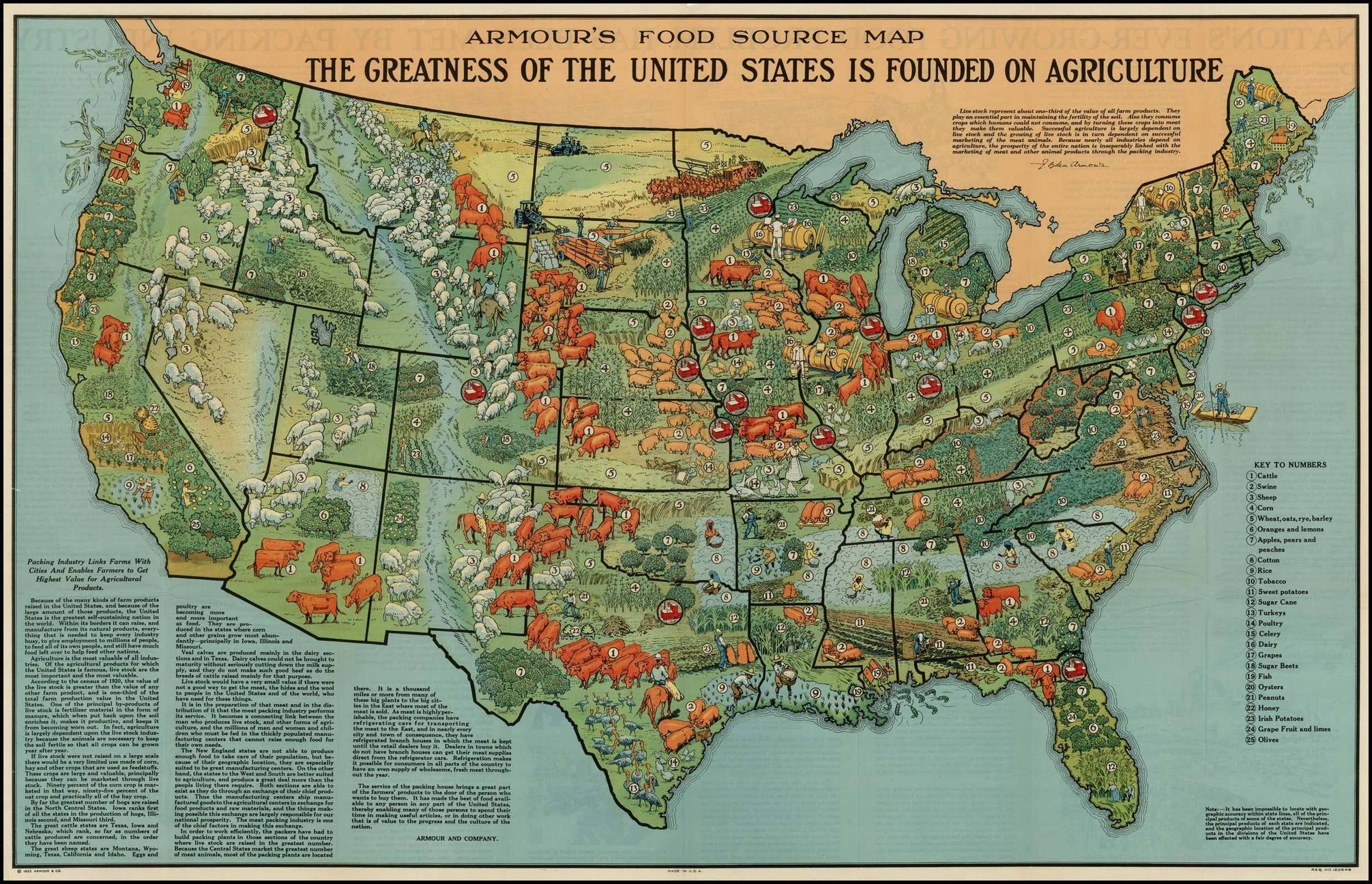
The bucolic postwar image of the fertilized land removed from war proclaimed American greatness, conspicuously omitting the multiple brush fires that spread across the midwest areas stripped for lumber and Powell feared might devastate forests in the Rocky Mountains, whose future sustainability he feared in 1870, after the destruction of forests by the timber industry increased interest in fire protection, before uncontrollable brush fires as the massive and terrifying Peshtigo fire of 1871: the greens of rows of irrigated fields omit how brush fires of 1910-8 in the northern Rockies destroyed three million acres of forested land–an estimated $1 billion of lumber; and barely register how “slash” fires spread from sparks across Wisconsin, Michigan, and Minnesota–Armour Foods mapped sources of plenty that barely register the devastatingly destructive conflagrations at abandoned piles of slash, highly flammable logging debris left by lumber companies. The green continental expanse affirms national “greatness” in its production of beef, pork, and mutton from the cows, pigs, and sheep that populate its lightest green plains, as much as its agriculture; the vision of such irrigated lands were confined to clear boundaries.
The map omits the devastating decline in future years of the flow of water by Bureau of Reclamation dams redefined the river in the course of the twentieth century. The story of draining the flow of sediment or water below the border, and the redirection of water by reservoirs and dams–a decade that marked a massive curtailment of river-flow of the Colorado, and ensured the low flow south of the border from the 1930s, as the diversion of the river’s waters irrigated crops for livestock feed. If the decisive fall occurred after the construction of the Hoover Dam filled in 1935-41, the decline to but a third of the abundant flow to the Mexican Border and Sea of Cortez in 1920: after a peak flow of the Colorado, the precipitous decline in future years reflects the massive re-engineering of river-flow of the Colorado to be allocated in a national infrastructure of irrigation, rather than flow to the sea.

Before Filling of Hoover and Grand Canyon Dams
The project of irrigation created a fiction of abundance based on the large number of reservoirs for irrigation that had created a fiction of farmlands open to settlement. The transformation of western states into lands of pasturage was implied a striking pictorial map of that year, all but erasing the hundredth meridian, depicting the diversity of crops and livestock as a national encomia–even if acknowledging “it has been impossible to locate with geographic accuracy within state lines”–that imaged national greatness for the largest American meatpacking company. Armour Food promoted “agriculture” but featured prominently cattle, sheep, and pigs fed by fertilized fields across irrigated basins hued green; the fields allowed slaughterhouses to be run free from government oversight or regulation, labor unions or food safety laws, promoting the benefits of irrigation underlying the bounty of meat in a fertile green land–a modern encomiastic vision of imperial grandeur emulating bucolic view of the newly united Italian peninsula as a land of ever-fertile farming, nourished and chosen by the Gods, as if rehabilitating a mythic geography from Vergil’s poetic Georgics, rather than examining its semi-arid lands.
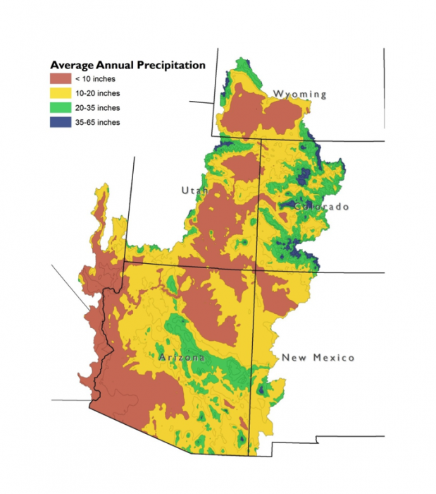
The tools for visualizing the distinct conditions of drainage basins were amplified in Powell’s map with different hues and shades not only to suggest the different soil-qualities of their topography, but to parse the distinct topographic variations in the lands of the “Arid Region” as it was understood as an area of future settlement, priming senators to consider the need to process irreconcilable differences in drainage basins with the drawing of state lines, for fear of their inadequacy of managing water allocation in their boundaries: the inter-state compact was a work around for the failure to map water allocation onto local demand. Soils have dried increasingly across the west due to even more decreased rainfall in the arid region, the problems of processing differences in water allocation that we will be increasingly faced over time pose questions of good government as temperatures rise across the world.
8. While we have focussed on emissions, and on climate in terms of CO2 in the atmosphere, global heating has caused soil-moisture to plummet across western states and world the stand to distort our relations to the land, suggesting the unstable nature of the ground on which we live. The perversion of allowing energy industries to so suspend democracy, and allow an unregulated markets to become the status quo that have accelerated the aridity to such an extent that we have alienated our relations to the land and to engineering the reallocation of Colorado’s river flow. Powell’s map may however challenge us to develop better flatscreen tools to visualize and comprehend the scale of the reduction of water in a region of increased aridity, long before farmers arrived there with the promise of growing sufficient crops for meat–a scale enabled only by engineering the diversion of water far beyond the drainage basins themselves.

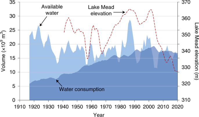
While aridity is an increased condition of the American West, and with it the reduction of the upper watershed of the Colorado River, demand for the consumption of water has led the level of Lake Mead to plummet for reasons many suspect related not only to urban growth,–but demand for beef: if greater heat decreased aquifer recharge and watershed evapotranspiration by a third, but steadily increasing of water consumption above river-flow has depleted the river whose and dried out the delta to mudflats, before water levels uniformly across man-made reservoirs across the west; remaining river-flow diverted west of the hundredth meridians irrigates “cattle-crops”–alfalfa; hay; sileage–consuming half water in the Colorado Basin (55%), depleting already depleted water reserves in an average of 75% across 369 sub-watersheds, and consuming a third of water across the western United States.
The declining elevation of Lake Mead, even in an age of extreme aridity and global warming, appears powered by the devotion of the market to meat, and the insatiable appetite for hamburgers and steaks, which hovers about eighty-two pounds/capita, and perhaps boosting outsized demand for steak in California, Nevada, and Washington. The image of false abundance that the meat industry first embraced and long promoted in the early twentieth century as engineered by the state lives in protests of the curtailment of water rights that have been expanded to grow artificial crops for meat in the semi-arid region, on a scale far greater than Powell had ever imagined, that rests on the engineering of massive water diversion schemes. In calling curtailments of water flow “unjust,” and defining allocations of “farmwater,” protests perpetuate an artificial construction of animal husbandry in response to demand for meat on a scale larger than Powell imagined, rejecting the focus on local water supplies Powell had advocated.
Spatial Climate Analysis Service, Oregon State University
When Powell argued that water could only reach the potential settlements for pasturage across the ‘Barren Region’ east of the Rockies by a massive system of canalization projects, he both invited the U.S. Congress to consider the administration of water rights on a greater scale than had been previously attempted, and to look at it not in an optic of state’s rights, but a logic of allocation by directing attention to local water scarcity. The protest against curtailing surface water supplies that the State Water Resources Control Board announced as a reduction of water by “Big Government” for that undercut famers’ rights introduced the term “farmwater”-to exploit the longstanding ties of farmers collectively had to harvest crops, as if this were a corporate right if not a state’s rights issue, rather than an issue of climate change. Althought California lies largely outside Powell’s Arid Region–expanded its image as a site destined for agricultural abundance, and the advocacy group that demand further investments in water supply from the state had as its slogan “where water flows, food grows,” a modern reworking of “rain follows the plough,” that denies the limits of surface water rainfall regionally provides. But the declining recharge of groundwater in California was an emergency of national dimensions, far greater than the alleged “national emergency” of the US-Mexico border, the desecration of federal property, or civil unrest in the nation’s northwest. Low recharge levels across the state and a steadily declining snowpack habituated farmers to low groundwater levels and left them reliant on water allocations, sending currents of confusion and geopolitical panic that booming urban economies did not register, as if the arid regions had migrated west, occasioning Inter-Basin Transfers to water to begin.

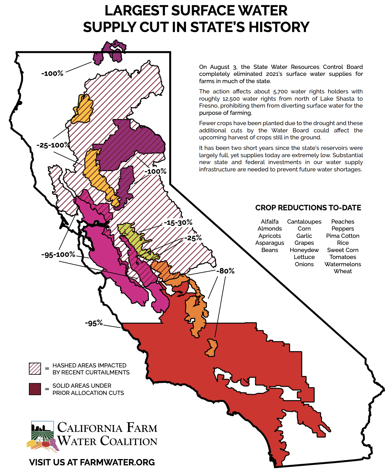
Although “famers” connote a lower class exponents of local interests, dedicated to help bringing food to table, and farming seems anodyne, and indeed beneficial to the land, the terms disguise large interests and large advantages to profit from allocations of water often devoted to feed for heads of cattle and steer in the region it is based. The exponents of such industries have demanded continued entitlements. to surface water, even in an era when surface dryness and aridity has led to the increasing dangers of fires and property loss. But the fierceness of launching such an attack on water “elimination” of “water rights holders” ranging from north of Lake Shasta to Fresno suggests not a hardscrabble collective of bargaining, but a group standing to except itself from the declining water reserves that lay in state reservoirs across the board–which far from not declining have significantly lower tables.
The states’ rights optics suggested the longstanding commitment, asking, given the fullness of California reservoirs but two years ago, whether mismanagement more than climate change contributed to an impending curtailment–counseling prudence, rationality, and “science-based” responses, rather than risking decreased alfalfa, almonds, corn, lettuce, peaches, cantaloupe, tomatoes, and wheat to grow, shocking viewers to respond with indignantly and passionately at the prospect of prohibiting the continued diversion of surface water for farming. The false division of a specter of class struggle conceal the degree to which so many watered crops are watered by flooding fields, and how many croplands are dedicated to feed. If some 80% of winter vegetables come from the basin, “farmwater” is an opportunistic coinage conveniently omitting how decreased rainfall and groundwater extraction reduced water for regions whose climate is already semi-arid and facing low levels of rain or groundwater–or that much water sent to the Imperial valley relies on out-of-state reservoirs such as Lake Mead. Low levels of recharge did not offer any perspective on the apparently unilateral manner that the Orwellian State Water Resources Control Board had “eliminated 2021’s surface water supplies for farms” as if this were an aggressive action of out of touch elites.
The region Powell defined by its limited opportunities for irrigation is of course facing a far more extreme drought and excessive heat. One might peel off the layers of Powell’s colored map, with the distance of time, to interrogate the effects of the partition of waters of the Colorado by legal compact–akin to the Mosaic breaking of the waters–to investigate the effects of such a deep rewriting of the distribution of moisture and aridity across the west. What might be called the”super-semiotic coloration of the “districts,” Powell’s maps partitioned the region by criteria of the limits of its settlement and water management by the units that the west could be mapped, superimposing districts above states that, in the aftermath of the U.S. Civil War, would have had increased agency of self-determination. Although western states bristled at the suggestion of such constraints, the separation of land from water, and the deposits of mineral deposits are revealed as the inflow of water to the river had declined.
Powell’s map is compelling to us today because it opens the inevitable morass of conflicts–now understood on legal terrain where they unfolded–between the administration of water “rights” in the responsibilities, obligations, and promises to states, rather than drainage basins, even as we no longer have the surface water or perhaps even the groundwater to meet obligations enshrined in 1922. But the tensions that Powell’s map is often praised for revealing, between the scientific limits of surface water and population, has been dangerously distorting as it rests on the conservation of existing water supplies, as if water supplies were able to be parsed in national terms, and might exist to fill an unsustainable demand correlating to a growing demand for beef, only recently declining, that increasingly grew demand for meat crops to allow beef consumption to grow staggeringly through the 1980s.
The hubris of Powell’s map may lie mostly in its mapping of. drainage districts of the Arid Region in terms of water allocations on national terms. Although the Colorado River Basin clearly straddles two countries, the focus that the map placed on drainage north of the border construed river management as an allocation of national resources, as if the Colorado River need not read the ocean–as it no longer does, and has not since 1960, save for planned events, parsed as its flow is between Arizona, California, Nevada, New Mexico, Utah and Wyoming, as well as Colorado–the only state that does not import water from its neighbors in the American west. The mapping of a region’s administration of water “rights” did not correspond only to state lines, but defined how landholders had rights to expect the allocation of unpolluted water from streams on which they lived and owned land for livestock, reconstructing the flow of water and its transference around livestock raising, that led to the foundation of federal “irrigation districts” as public entities, administering “rights” to water within the territorial United States, separate from other federal agencies, or any broader assessment of groundwater needs or the water table. Water was allocated in federal irrigation projects to turn public lands over to private hands, treating the presence of groundwater as a fungible good best understood in a language of governance, removed from landwater needs or the role of the transit and transportation of water outside of “jurisdictions” of manmade irrigation systems.
The damming of the river at “Lake” Powell cut off all water supply to the river’s delta between Sonora and Baja during the1930s, as the reservoir filled for six years, and all sediment flow to the delta was reduced, devastating the local ecosystem in ways we barely noted or studied, as all water was captured behind the dam, in anticipation of electricity generation, and the subsequent construction of the Glen Canyon Dam in the 1960s again reduced all river-flow to the delta, now a mudflat, brackish from agricultural runoff that had so compromised river water to demand desalination plants before it crossed the border, rich with fertilizer and stripped of nutrients. Low sediment discharge compromised a coastal ocean and rich freshwater ecosystem nourished by sediment and silt to sustain spawning, feeding and nesting for fish, mammals, and birds, converting a wetlands ecosystem to a cautionary premonition of a terrifying future, as increasingly brackish water had so altered the old river bed to make it inhospitable to wildlife.
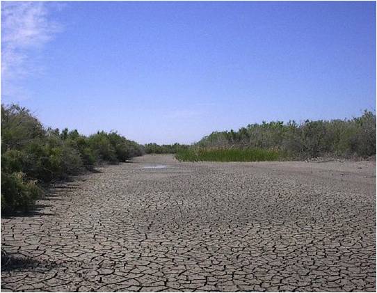
9. The starving of sediment has devastated populations that once lived on the estuary, and altered flight paths and migrations of marine creatures, insects, and birds, that have created an arid region to the south of the border that was conveniently left off of Powell’s map–and not only because he was addressing the U.S. Senate, but because the natural abundance in a delta offered three thousand miles in which Aldo Leopold in 1922 paused, uncertain which of its “hundred green offered the most pleasant path” to enter the Gulf of California–finding that at dawn on the Delta, surrounded by quail, egrets, cormorants, avocets, mallards, and teal springing skyward in alarm, that whereas “on the map the Delta was bisected by the river, . . . in fact, the river was nowhere and everywhere,” trying to navigate among “which of a hundred green lagoons offered the most pleasant and least speedy path to the Gulf [of California].” Where we see an absence of life in a dry river bed, Leopold, amazed by the different landscape from Wisconsin’s plains, recently bereft of pigeons, moved lazily, struck by the clouds of birds and egrets, a “wealth of fowl and fish [he soon realized] was not for our delectation alone,” as he saw a bobcat, families of raccoons, and coyotes eager to nab an unsuspecting duck, shore bird, or quail. Leopold never saw a jaguar, but lamented by 1949, when Sand County Almanac was printed, that “a glory has departed from the green lagoons.”
In place of Leopold’s dense description of a vibrant ecosystem lies a cracked parched riverbed of silt and barren mudflats, apparently bereft of life that crowds its banks. It may have been karma that led the conservationist to the delta in the very year the interstate compact of the river-water that ensured its disappearance was signed, but a keen awareness that the river whose flow was both “nowhere and everywhere” in these ecologically rich region constituted a unique “land of milk and honey,” inhabited by a density of egrets, avocets, cormorants, and willets, he had not seen; on its banks, he saw deer, jaguars, beavers, coyote. (The region that has since been substituted as a site for migratory birds by the saltwater runoff arriving from Arizona fields in the mudflats of La Cienega de Santa Clara as the estuary enriched by sediment flow will not return.). The north-shifting of an image of a bucolic region in North America has been one of the most tragic man-nade modifications of the terrain. Westward the course of empire indeed: the anthropogenic modification that has drained groundwater from the Colorado Basin has been hard hit not only by drought, but the retention of sediment whose traces one can se in the white bands on the artificial banks of the man-made reservoir. Over the last fifteen years, drainage from the Colorado River’s upper basin of the Colorado sunk to the lowest level in the history of the existence of the accumulation of water behind the Hoover Dam, below the spillway gates–and may trigger extensive water and power reductions across seven states, that the melting of cables for public transit in Portland and the buckling of Washington highways can but hint.


