
10. If global warming has placed us far beyond a logic of water allocation, the interest of mapping aridity and soil moisture–a key variable both to the measures of the increasing combustibility of western landscapes, and to the intense ratcheting up of the dryness across the upper basin of the Colorado River of the past ten to twenty-five years. In ways that resist a time-series chart or slider bar, the drying up of the region that was once fed by the riverflow of the Colorado River–once treated as a source of God-given bounty–the “American Nile”–suggests how Manifest Destiny has reached a new collision course with global warming that stands to undermine the hydrological infrastructure of the west.
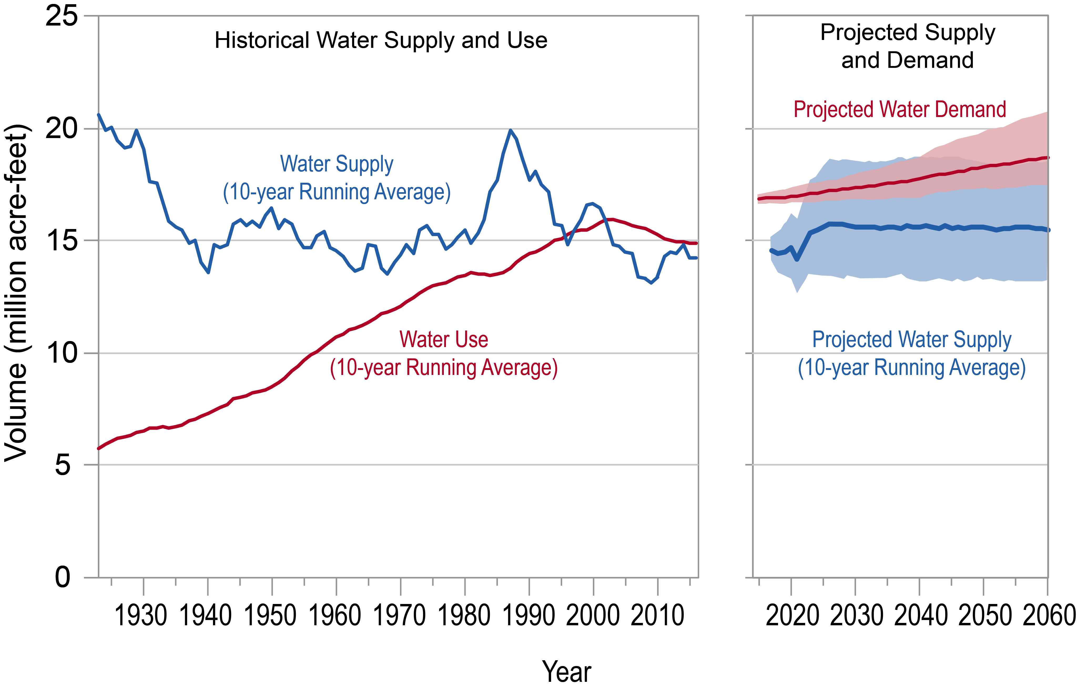
The plan to provide the west water nation from the river’s upper basin for centuries to come–or at least a thousand years, without considering the undertow of the increase in the demand for water across western states that have considerably grown in population and in agricultural production since the 1920s, when demand for a multi-purpose damming of the lower Colorado began a new “The Law of the River” governing allocations of water, exaggerated in their scale as they extrapolated what was a very wet period of river-flow with unwarranted optimism.
Increased construction of dams on the Colorado and its tributaries to meet states’ “rights” and “obligations” allowed expanded irrigation of dry lands that set the stage for an unsustainable increase in demand for river water, that were transferred to urban use. Water supplies seemed to grow as the late 1980s brought a temporary rise in water supply, yet growing demand from cities, independently from how river-flow, caused supplies of water to shrink. Water storage capacities created in reservoirs built from the 1920s to 1960 met demand for water, but “droughts” of the 1970s, when dam-building projects decreased and environmental criticisms of reservoirs grew, paralleled growing agrarian demands for water in Arizona, the salinity of the Colorado from agricultural run-off, and increasing municipal demands from cities on the periphery of the lower basin–Albuquerque, Denver, Los Angeles, and San Diego–for drinking water, separately from agrarian allocations, putting huge pressure on the supply of clean water to make Powell shake his head–and creating demand to tap groundwater reserves along the Colorado River.


We have begun to speak of a “psychology of global warming” of neoliberal entitlements and exceptionalism defined by absence of care, erasing awareness of an ecology beyond our own consumption and dependence on fossil fuels. The psychology of global warming, described by Sally Weintrobe, brackets out environmental effects of energy use, in a logic that echoes how maps bracket and isolate national needs and entitlements from a greater biosphere, or unregulated market. Maps facilitate a bracketing that cannot be identified with one part of the political spectrum–neo-liberal, pro-market, or even free-market–by foregrounding a logic of extraction and liberating resource exploitation from restraints, across an ideological spectrum. It perpetuates an exceptionalism epitomized by the fantasy of being able to reorganize reality and ecological relations on a scale earlier inconceivable. A narrative of American Exceptionalism was resuscitated by the promise to Make America Great Again, defying ecological realities by hubris of affirming the over-riding priority of American needs, as if to impose economic order on global water flows and local habitat. If the neoliberal demand for deregulation allowed the wall to be planned, revealing the bearings of neoliberalism not from from ideologies or technologies of extraction, then an ability to deny realities that threaten collective entitlements.
11. Maps facilitate a mindset or dynamic of “exceptionalism,” by focussing on national interests and needs they frame and prioritize. Maps act as descriptive tools whose authority naturalize desires to blot out what lies beyond borders, and to remove ourselves from a global context, or an ecology or ecosystem not present on the map, replacing them with an ability or need to confront the clearly-drawn edges of space. The priority of of entitlements became the basis for a border wall between the United States and Mexico–entitlements as better wages, ethnic nationalism, and crime prevention; the conceit of a border wall affirms entitlements for protection of threat other realities present on a gut level, rather than finding rational grounds of support. In confirming the existence of threats sensed on a gut level as feelings, border walls erase and displace all practical constraints, but promise to reorganize reality on such a massive scale by redrawing borders as dangerous edges: the promise of available water by redirecting a massive river’s flow for national interests replace realties in a similar way, by reading or refracting river-flow through the divide of the borders. Technologies of re-engineering water-flow redefined the scale of water-management, shortly before we began to register or appreciate global warming, in ways that created a crisis for trans-border flow of water to what we are only recently realizing demands cross-border management as a hydroregion in itself, as its own population grows, and management of water systems on federally-owned lands.

Shared Watersheds on US-Mexico Border/Woodard and Durall, 1996
The massive project of historical re-engineering the flow of the Colorado expanded the aridity of the basin to a new scale, allowing an unprecedented privileging a national exceptionalism of entitlement on unprecedented scale as a model of protecting national interests. Damming the Upper and Lower Basin of the Colorado recast groundwater extraction from the basin, both providing energy through hydropower and recasting the diversion of water to an inter-state compact as if it were asking to a tap, or pursuing the geographic myth of the existence of artesian water springs able to expand to provide for the demands of its inhabitants.
The pumping of basin groundwater has grown in volumes as if to compensate for drought to meet national needs: over-extraction of groundwater has depleted an astounding 41 million acre-feet of water — nearly 77 percent of the 53 million acre-feet of freshwater of the Basin’s groundwater “stock,” reveals remote sensing of satellites in NASA’s Gravity Recovery and Climate Experiment (GRACE) that calculate changes in the Earth’s mass, suggesting a second massive shift in the aridity of parched land of limited abilities for recharge. While we hoped that groundwater repletion would sustain the upper Colorado even during climate change, according the Bureau of Reclamation in 2016, the diversion of river-flow and extraction of groundwater from the lower basin has parched out the lower basin beyond recognition.
The resulting groundwater depletion is of such unprecedented scale to prevent reservoirs from replenishing–but produced not from higher temperatures and reduced rainfall, but unbounded appetites for groundwater extraction. The diversion of river water to fields almost entirely exhausts what river-flow is left to cross Mexico’s border; whereas transferring water to eastern states depletes the Colorado River north of Lake Mead, the river is fully drained by the time it reaches the border due to the watering of crops for cattle feed–hay, hayage, corn silage, sorghum sileage–that so drain river from the headwaters to plunge flow beyond natural levels. As much as limiting water-use by farms, with rain-levels low, we have relied on increased pumping from aquifers and inter-basin transfers that further stress soil quality in the basin; as massive dammed reservoirs empty or grow low with low rainfall, and rising heat, we have created drier conditions across the west, left to watch the declining water levels, and blame regional heating and global warming for extensive depletion of groundwater deficits.

