Monthly Archives: December 2013

Sacred Toponymy Matters: Framing Canaan, between Sacred Site and Jurisdiction

Symbolic maps of the Holy Land are unlike the local maps created for establishing territorial boundary lines or land-ownership that set.  But they have come to enshrine shared precedents and common recognized grounds of law, defining property lands of cultivated land.  Such maps acquired the status of legal precedents–indeed, they were ways of enshrining rights of possession in the law, even when limited legal grounds existed for territoriality or for dividing rights to areas where no evident natural boundary existed, and were to an extent imitated in these maps of the Holy Land.  The influential fourteenth-century jurist Bartolus of Sassoferato, among whose many briefs of Roman civil law  one had defended the legal governmental rights of city-states in the area of central Italy, famously appealed to the authority of maps to resolve disputes over river rights and alluvial deposits between towns by maps.   Although Bartolus’ influence, considerable before 1800, developed outside of a clear notion of government territoriality, he appealed to maps to resolve ownership boundaries outside of local statutes, in ways to create a common understanding and consensus about the occupation and ownership of a potentially disputed plot of land. The determining tools of cartography afforded the authority for manufacturing the map in ways that provided a precedent for drawing property lines, and bounding a landscape’s expanse which could be regularly provided and widely recognized.  This 1689 image of Bartolus’ treatise on the manners of measuring river rights uses a quadrant of Euclidean derivation to transpose a river’s winding serpentine course into geometric fixity, translating his discussion of to seventeenth-century surveying practices. illus244s Lines of jurisdiction are of course still particularly fraught, despite Bartolus’ appeal to the rule of the quadrant, and difficult to transmit, and not only around rights to rivers, some centuries later, but the value of maps in recording an authoritative transcription of rights emerged as a powerful judicial concept in similar quaestio, providing a precedent to which one could appeal as a form of priority. The authority of the map as a form of access to a precedent emerged in a context of reading that shifted from historical terms to juridical terms in an oddly circuitous way, in which the conjuring of territories came to be invested with quasi-legal qualities; indeed, to argue that the map conjures the territory or synthesizes it into existence collapses the complex process of mediation, causation and transmission, in which the map serves in very powerful ways. Sacred maps demarcate a sacred space that collapsed historical time in powerful ways. But once translated into historical terms, such maps materialized cartographical precedents, even if they when more rooted in a cartographical imaginary than in surveying practices or jurisdictional claims of a state. But historical maps of Palestine acquired a sense of authority as precedents in what might be seen as a sort of cartographical promise, as the map came to offer a tangible image to the historical imagination that also suggested a record of historical precedent.

For although they were less easily treated as precedents of similar binding force, historical maps increasingly came to stake claim to the inhabitation of the land. And in few cases can the relation between map and territory become more fraught with complications, and more delicate–especially when the same map is also being used to construct a nation, and is so strongly conjured from biblical writings as a way to imagine the existence of a new homeland. The historical maps of Palestine, framed in considerable detail long before the eighteenth century rise of jurisprudence, offered a compelling basis to organize and encourage readers’ familiarity with sacred toponymy and bounds that long anticipated European settlement of the land–and encouraged increasingly complex narratives to be attached to their own reading. The description of the historical borders of ancient land of Canaan encouraged an outpouring of early modern cartographical materials in the first age of widespread cartographical literacy, or familiarity with the authority of the map. The expansive fourteen-sheet wall map of Canaan executed by that industrious seventeenth-century mapper of England‘s territories, John Speed, is lost, but it expanded the 1611 “mappe of Canaan” he designed for the King James Bible–whose design was sufficiently tied to his cartographical competence that he secured a privilege for its reproduction. The map organized narratives about the Holy Land in ways that invested the region with a clearer sense of territorial identity it seems not to have earlier enjoyed. When Speed mapped the Holy Land in the seventeenth century, the map created a model for reading biblical space; William Stackhouse amply provided extensive maps in his 1744 New History of the Bible from the Beginning of the World to the Establishment of Christianity as historical documents of the boundaries dividing Canaan: the map of Canaan in his History afforded a material basis to understand how the Roman census divided inhabitants of the Holy Land, a territorialization of tribal divisions lended concreteness to the occupation of the region by Israelite tribes into discrete regions administered by Roman governors on clearly drawn lines. The national maps that Speed had earlier fabricated provided a precedent for mapping Canaan–not only as the “eye of history,” as the humanistically-educated Jean Bodin and Abraham Ortelius proffered in their maps–but as a form whose boundaries constituted something like a precedent to a modern nation-state. Speed had received a privilege for his “description of Canaan, and bordering countries” in 1610 that took advantage of recently increasing cartographical literacy to extend biblical readership by supplying maps of ‘the Ancient World’, ‘Palestine as Divided among the Tribes of Israel’, ‘Palestine in the Time of Christ’ and ‘The Eastern Mediterranean World in the First Century.’ Such images recast the functions by which maps invited religious meditation in the early printed bibles of Lutherans, by evoking territorial terms that prefigure if not invoke sovereignty. The curate Stackhouse, former grammar school headmaster expanded the authority of engraved maps in Bibles printed from 1733, and expanded in a two-volume edition of 1742-4, “rectifying Mif-Tranflations and reconciling feeming Contradictions, the whole illuftrated with proper Maps and Sculptures.” In it, Stackhouse’ “Map of Canaan, Divided among the 12 Tribes” was a surrogate for the map Revernd Stackhouse surmised with due consideration God provided “to shew Moses the compass of the land.”

Twelve Tribes Mapped in Stackhouse by Hinton

The Reverend Stackhouse explained to his readers that, given the difficulty of displaying the land of Canaan from Mount Nebo, “Jews indeed have a notion, that God laid before him a map of the whole country, and shewed him therein how every part was situate; where each valley lay, each mountain, each river ran, and for what remarkable product each part was renowned”–although he expressed doubts that this was the case, since it would dispense with any reason to ascend the mount “since in the lowest plains of Moab, he might have given him a demonstration of this kind every whit as well.” But what Moses saw from the mountain was itself quite comparable a map: although the “visive faculties” required to see Dan and Mt. Lebanon to the north, and the lake of Sodom and Zoar to the south, or the Mediterranean to the west and land of Gilead to the northeast, were “a compass above the stretch of human sight,” scriptures had it that the 120 year old Moses’ eyes “were not dim;” no doubt, Stackhouse surmised, “God strengthened them with a greater vigour than ordinary” that “‘gave his eyes such power of contemplating it, from the beginning to the end, that he saw hills and dales, what was open and what was enclosed, remote or high, at one single view or intuition'” (vol. III, chapter IV, 34-5) The visual presence of the map that Stackhouse imagined bequeathed a sense of concrete entity and identity to the territory that no doubt reflected the authority that printed maps of England had recently assumed, and indeed that the map had assumed as register of national identity. The notion of demarcating a legal territory in biblical times echoed the five maps Speed designed for the King James Bible, and gained a privilege for designing, although based on the earlier efforts of “the learned divine” John More. These maps were commissioned to encourage vernacular biblical readership, but respond to a sense of cartographical literacy unlike earlier maps of Palestine or Canaan. Speed’s maps coincidentally paralleled his project of uniting the parcels of English territory in the 1610-11 Theater of the Empire of Great Britain, creating a composite legible image of national sovereignty across England, Wales, Ireland and Scotland, in ways that abstracted an entity from the land that was earlier difficult to be cartographically imagined. The widespread republication of Speed’s atlases and Theater in the 1670s and 1680s that included maps of “His Majesty’s Dominions Abroad” on its title–and maps of New England, Virginia, Barbadoes, and the Carolinas, broadening the canvass of the nation. Reverend Stackhouse built on this precedent of recording imperial unity by offering a territorial explication of biblical narrative in his New History of the Holy Bible: his “proper maps” were proper since they set a standard for the symbolic mapping of the region that might have been read by Abraham, and offered a basis to understand the distances from Nazareth to Bethlehem as bound by legally binding frontiers, linking the name of each tribe to a region that reflected the Roman imperial administrative divisions drawn across the Holy Land, as much as its cities. In addressing a larger readership of printed bibles, such maps concretized a detailed and palpable relation to the territory.

The translation of the findings of surveys to such widely diffused maps–and the translation of surveyors’ findings from these maps to later maps that won a large readership in sacred texts–deserves to be examined as a subject of cultural history.  To argue that the map conjures the territory or synthesizes it into existence collapses a complex process of mediation, causation and transmission, in which the map delineated an imagined “geobody.”  And the emergence of “historical” maps of the Holy Land raises questions of how the map only becomes the territory over time. Where the palpability of such images derived from, and how they were deployed for a wide readership across a broad geographically dispersed readership, raises questions of the sort of cartographical literacy that came to be communicated about the Holy Land. The layers of translation from territory to map and back again open something like a chasm of misreading how a map maps to a land.  The attempt to restore the bounds of a broader “Greater Israel” beyond the national bounds of the nation–and returned its bounds to the “Promised Land” described in Ezekiel or Genesis 15:18-21–bizarrely transpose a sacred text to the project of  the mapping of the nation, current among some  more right-wing parties of the current Israeli state.  The multiplication of alternative maps expresses a dueling between contesting visions, still needing to be fully mapped, and exchange between an imagined unity and the state’s actual boundaries.  As the reality of the state of Israel has grown, the map that informed it, however, takes on new urgency–if only because of the expansion of a mythical-historical perspective on the identity of the same land.

Palestine1100tribes

The inclusion of a series of geographically situated Battlefields of the Twelve Tribes in this 1864 map of the same territory lent considerable tangibility to the map of the Holy Land as a detailed historical topography, based on the current surveying of the same landscape.    The positioning of the sites of ancient battles against this field of clear elevations, hillocks, rivers, the Dead Sea and other topographic realities created a sense of concreteness that bestowed a sense of strategic encounters in an actual lived terrain–something of a proxy for the hopes for territorial repossession of an actually remote sacred land:

battles2

Did such glorious four-color relief maps, published before the Hungarian journalist Theodore Herzl called for the creation and foundation of a Jewish homeland in his 1896 Der Judenstaat, help to conjure the territory? For by 1897, Herzl described the goals of Zionism “to establish a homeland in Palestine [that was] secured under public law,” the idea gained resonance because the map had already concretized a claim to the territory and the “legally assured home in Palestine”–long before the the 1917 Balfour Declaration affirmed “the establishment in Palestine of a national homeland for the Jewish people”–transposed the sacred map into a legal precedent, mapping a mythical historical toponymy onto an actual territory in ways with which we continue to struggle, and to which numerous counter-maps have been articulated at the same time as maps are used to try to narrate the geographic displacements and renaming that occurred–so often in the name of remapping the map to the territory, and re-asserting the complex narrative that was itself generated from the increasingly fraught relation between territory and map. The concrete detail of the maps realized the imaginary existence of the region with a concreteness that provided a recognized and recognizable image of lands settled by the Twelve Tribes by 1900 as if it were their property.

israel-holy-land-divided-amongst-12-tribes-section-from-east-to-west-1900-map-73345-p

And, to jump wildly–and fairly irresponsibly, it must be admitted–across time, after 1948, the negotiation of these sites of settlement and creation of places of habitation was considerably more complex to negotiate, as this recent map of Israel’s relation to the occupied territories reveals, a process of negotiation building from and negotiating the attempt to integrate Gaza or the West Bank in an earlier notion of a “Greater Israel.” More pressingly and compellingly, than this cartographical fantasy is the manner that the image of land defined the bounds of the land’s inhabitants by 2007.

West_Bank_&_Gaza_Map_2007_(Settlements)

The “other” side of the historical story is presented in this 2012 map of the scope of the declining expanse that was bounded in the Palestinian state from virtually the same date–1897–up until the present, a map that seeks to conjure, if it obscures the human cost of displacement of some 5 million Palestinian refugees from the 1948 and 1967 wars and their descendants, now living in Jordan, Libya, and Syria, as well as the West Bank, at a moment commemorated on May 15 as the Nakba Day [يوم الن], or the Day of Catastrophe.

Map6_RefugeesRoutes

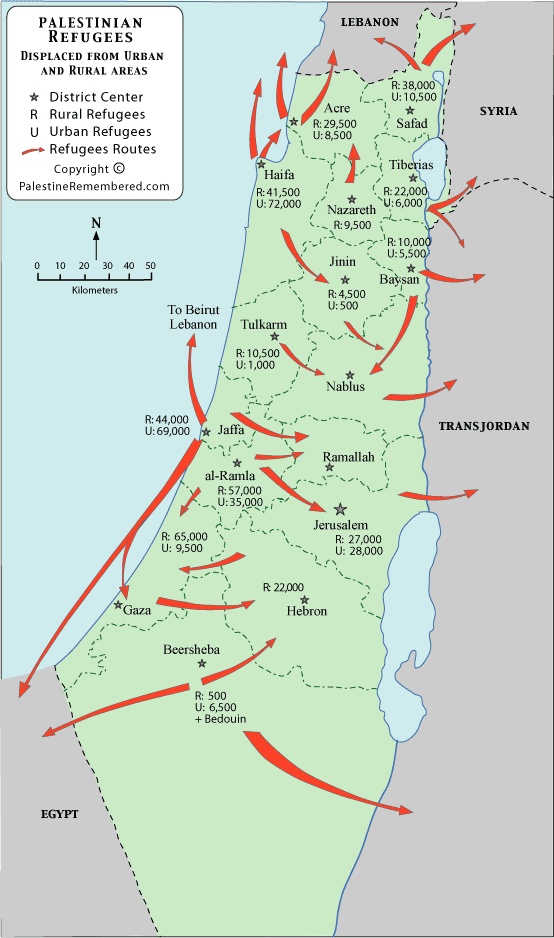
The map is striking for how it reveals a counter-example to the above fantasy of occupation–paralleled a renaming of the land, and a government committee dedicated to the erasure of some thousands of Arab place names, from cities to hills, valleys and springs, was delegated with the task of creating Hebrew names as when David Ben-Gurion affirmed “We are obliged to remove the Arabic names for reasons of state,” dedicating the nation to the project of determining place-names in the Negev, or southern half of Israel. For a more expansive version of this post, please click here.

Leave a comment

Filed under Bartolus of Sassoferato, Holy Land, Israeli toponyms, Israelite Tribes, Mapping the Holy Land, Michael Chabon, Nakba, Traditional Palestine, Twelve Tribes, William Stackhouse

Sacred Toponymy Matters: the Territory in the Map

In very few cases are the associations of place-names so powerfully resonant as in those that derive from a biblical frame of reference:  they speak across time, in a powerfully incantatory way, unveiling a sense of space in maps, and claims to that spatial jurisdiction.  Palestinians ruefully note that Jews–or Israelis—live in ruins, the myth of their past inhabitation inhabits the present through place-names on a map, and on a scribal map, as it were, that underlies the most sophisticated GPS claims to boundaries: if geopolitical boundaries are determined by hexadecimal coordinates of GPS in current treaties, textbook maps in the Israeli courses of Civics frame the territories won in the 1967 Six-Day War as a historical geography of liberation of lands in the West Bank that fulfill “a return to Judea and Samaria, areas where our patriarchs and matriarchs lived” and “where the Kingdom of David and Solomon was established.” The regions are identified as physical loci of collective memory, and indeed invested with elevated status as places to almost sublime transcendence of contemporary politics as constituting “the heart of the Jewish people,” more than contested lands. Such textbooks that instruct readers that “already in the Bible period, Jews lived in this area, and the Bible . . . this is where the patriarchs and matriarchs were buried,” evoking the lands and boundaries Jews gained as a people set forth in the Book of Numbers not as modern, but confirmation of expansion of the nation’s borders concluding a sacred narrative of the establishment of Biblical era, rather even if it is inhabited by Palestinians.

Such maps fulfill especially pernicious ends in failing to orient Israeli students to the world in which they live. One can find “Judea” and “Samaria” in books of Genesis and Joshua point to the Jewish presence in the region–although I first heard them referred to as places in the current world was when I moved into a condominium in Los Angeles’ Fairfax district, and was told by my neighbor Clara Markowicz that her husband was born in Judea, coming home with cans of goods she requested as I heard, in the stairway, of a region I had to ask as Israeli friend to clarify after I had brought her several bags of groceries in a gesture of neighborliness. The region had a concreteness in her mind as a birthplace, of almost mythic stature; the foundation of settlements that were often military outposts that became residential rapidly expanded as they were established after a pioneering rabbi founded a local yeshiva that seeded the settlement in the collective imaginary on a scriptural foundation that would later gain sovereign status within the rapidly changing arial map of “Israel” as a nation.

Local toponymy is rarely so transparently or so powerfully painted on a cartographical canvas to evoke of narratives of collective memory as in maps of the Holy Land, designed to orient readers to a sacred space, as much as within a territory–and to confirm the elision between past and present by the magical condensation of space that cartographic conventions allow. Although many of the best-known maps of the regions are reconstructions, the location of holy sites as Jerusalem, Bethlehem, Jericho, Caeserea or Mt. Sinai create points of entrance, more powerfully than siting points, for plotting multiple master-narratives across a historical gulf and spanning different epochs; the map is alternately the container and the field, the historical synthesis, but also the screen: Israeli annexation of 40% of the West Bank anticipates how a Trump plan would “turn temporary occupation into permanent occupation” over the land God told Moses would “fall to [the people of Israel] for an inheritance . . . in its full extent” in Numbers 34:2-3, as bounded by the “edge of the Salt Sea on the East.”  

The “conceptual map” for “Peace to Prosperity” a vision that Trump issued is proclaimed the “ultimate deal” ensuring sovereign unity of Israel, but proposed a very, very old idea of sovereign boundary lines. It was perhaps encouraged by his own love of borders, the plan pacified evangelical Christians who arrived to be volunteers in settlements and envisioned these new boundaries. Numbers 34:1-10 idealize the very boundaries of Canaan the Lord descibed “as an inheritance” extending to the Dead Sea –“up to the Salt Sea on the East“–as Israel’s territory only expanded to its full extent to the north in the time of King David, rabbis realized Pro-Israel evangelicals, skilled in the territorial visualization and eschatology, deferred questions of residents, wondering at living beside folk not sharing faith and lifestyle in the Holy Land–as strategic allies over the long term. If President Trump would be able to mimic the God-granted boundaries in his “vision” of the State of Israel that annexes land far beyond the current security barrier, and demilitarizes the West Bank by annexing some 40% outright, the sovereign expansion to include all settlements whose legality in international law has been intensely debated for over fifty years, but often reassessed “in light of new realities on the ground.”

The redrawing of the settlements on occupied land would be included in the “greater map” of Israel proposed, which demands interpretation against the deeper symbolic map sketched in Biblical pronouncements, rather than being defined by the new authority of GPS coordinates in international law:

Vision for Peace: Conceptual Map, January 28 2020

The power of such potent toponymy mark place by offering access to a sacred space, in ways that illustrate the dual deictic functions all maps have of showing or making present and of conjuring narratives.  So evocative is the verbal map of the region in scriptures that the map they help to weave and any later maps that respond to this image create a place where time collapses–where the present is poised to dissolve into the past. Current plan s for Israeli annexation of the West Bank in July 2020, given the green light by the Trump administration and the dauphin Jared Kushner, absorbing areas control by the Palestinian Authority and annexing areas all the way to the River Jordan, absorb regions now militarily ruled by Israel with a semblance or presence of local autonomy–“belligerent occupation” denotes more of a stalemate than peaceful accord–uniting areas populated by Israeli settlers into a single territorial unity and sovereign identity.

In one sense, the new announcement of annexation was a map of annexation issued by the Israeli government. But if the Netanyahu government announced it, the winking go-ahead was already announced in the “conceptual map” unveiled in Washington, D.C. by Trump January 28, 2020, by a U.S. President still in denial about reports he had received about the threat of a global pandemic emerging at brisk rates in China, already detected by the week previous by public health agencies in the United States, related to travel from China.

Can the characterization of this geopolitical map of expanded boundaries as a “vision” conceal the pandering to evangelical audiences of promoting a newly expanded Israeli territory? The deception of the map as a “vision of peace” echoed visionary maps of the Holy Land, long dear to evangelicals, as if to curry wishes of American Evangelical communities, and the hurried announcement seemed to solidify the map’s borders in the public imaginary, before the pandemic spread. The map that unifies the state of Israel with the Gaza Strip and West Bank, integrating the new infrastructure of an underground tunnel running between the West Bank and the Gaza Strip, seemed to suggest ready access from Beersheba to the Dead Sea, without having to pass through checkpoints,–and incorporate what were long deemed illegal redouts of “Israeli enclave communities” to a united and harmonious geopolitical unit, relegating the entire idea of a divided Jerusalem to the remote past, beneath the feet of Walter Benjamin’s Angel of History, and enshrining a non-contiguous Palestine: the prominence of these “new towns” on the map, in exchange for a freeze in future settlements–reversing a longstanding American opposition to West Bank settlements by a single map of new toponyms in the Samarian mountains, as Har Barakha, consolidated from Palestinian villages.

Vision for Peace Conceptual Map (detail)

The powerful biblical narrative of inheritance is so imbricated with the political map, so self-consciously entangled are map and text, or sacred toponym and physical space. Perhaps only a map can create such an entangled union that is presented as objective, or trick the viewer to read entanglement as objectivity. If the Old Testament discussed military maps, administrative maps, and historical maps, these were written, instead of drawn.  Reading the Pentateuch or New Testament extends an invitation to organize an image of regional coherence absent in the Hebrew or Christian Bible, however, and in a society where maps were increasingly familiar medium of information, they offered a powerful poetic and increasingly a polemic means to create a palpable present for readers of scriptures even when they were–or perhaps especially because they were–both physically and geographically removed from the region and the very space that they described, but preserved in a different space of the book, and through it into the very different register of collective consciousness.

Maps drawn of Palestine and of biblical history combine the ostensive functions of displaying place (showing) with the connotative functions of map signs to make present a landscape that was perhaps never seen as such:  in so doing, they show readers where they might be, and offer a map that corresponds to their reading of sacred narrative, and indeed of giving enargaic power to that narrative in the present.  But they are most powerful examples of a form of “distanced reading,” around which one can weave multiple narratives about the territory, or narratives of pilgrimage and sacred visitation, without necessarily going there and visiting the very sites that the maps situate before the viewer.  For the particular power of maps of the Holy Land lies in how they offer the possibility for a reader to enter the narratives as much as they provide a description of space.  When the most familiar verbal map of Canaan–“from Dan to Ber-sheba” (2 Sam. 24:2)–created a very loosely defined region, it allowed viewers to enter the specific sites it described.  Drawn maps served to frame the pilgrimage across and intellectual inhabitation of a region and emplot specific events for viewers who become, even when physically removed from the region, vicarious witnesses to an always-present Holy Land.

Continue reading

Leave a comment

Filed under biblical maps, historical maps, Holy Land, Israel, sacred territory

Mapping the Cancer Corridor along Louisiana’s Gulf Coast

“Cancer Alley” does not itself appear on maps.  But this eighty-five mile stretch of the Mississippi River between Baton Rouge and New Orleans, into which are packed some one hundred and fifty factories of petroleum refining or chemical production, merits the name since its notorious wastes have grown so large to define the local landscape to merit the name–the amount of toxic and hazardous wastes that they regularly release has overwhelmed the landscape, all but crowding out all local place-names.

The simple austere presence of names of chemical compounds, no doubt sized in an elegant Times New Roman in a font-size that corresponds to their relative production, suggests an imposition of meaning inscribed on the map, stripped of any actual toponymy, save the ghostly half-tones naming the corporations who have remade the landscape as a site of corporate refineries and chemical production, where the refinement of carcinogenic materials extracted from underground threatens to overwhelm the landscape:  a black thread of a river may be traced where the Mississippi meets the Gulf of Mexico, whose serpentine course of solid black carries broad public health implications for the nation we endanger ourselves to neglect.

05_OIL_CancerAlley

Kate Orff, “Ecological Atlas to ‘Petrochemical America'”

The banks of this Louisiana Bayou landscape on which so many sites of the manufacture of petrochemical products are nested, transformed a former a site of sugar and cotton plantations into one of the most polluted areas in the United States of America.  The petroleum refineries, chemical industries, and hazardous waste containment sites along the winding river are a stark contrast to the sinuous bends of the lower Mississippi, but suggest the deep transfiguration of place that has occurred, complicit with the erosion of so much of the wetlands region near the Louisiana coast into the open waters further downstream.  The smokestacks of factories of chemical synthesis produce clouds of emissions that have led it to be named “cancer alley” to reflect the high rates at which residents of the area.  Most of its current residents–largely poor, poorly represented, and largely African-American and with strikingly low levels of educational attainment–have been victimized by the discrepancies of environmental protection in the nation’s geography as a whole.

The question of mapping pollutants in the region is truly not only a map limited to one area, but suggests an atlas–a term Kate Orff adopts in her map–of the underside of the national consumption of petroleum products and their synthesis for American markets,  compressed to one small region of the lower Mississippi.  Even as American Presidents have taken it upon themselves to declare for over fifty years–we can date the metaphorical call for the moonshot that Joe Biden oversaw as Vice President to cure cancer all the way back in 1971, when Richard M. Nixon called for a national effort to conquer “this dread disease” from which Americans suffered through “the same kind of concentrated effort … that took man to the moon,” as if an anticancer blastoff was waiting in the wings, the “war on cancer” that Nixon sought to begin as the Vietnam War was winding, there was a sense that the “war” didn’t pay much attention to the grim landscape of postindustrial waste and pollutants and hazardous waste that refineries were emitting into the beautiful bayous where the Mississippi opens into the Gulf of Mexico whose dangers were claimed to be avoided and superseded by “research and therapies [that] are on the cusp of significant breakthroughs,”as Joe Biden Biden put it as he corralled the nation to join him in a national mission to develop both therapeutic treatments for cancer and liberate “science, data, and research results [that is currently] trapped in silos, preventing faster progress and greater reach to patients. It’s not just about developing game-changing treatments” promised to be on the horizon of being delivered.   While privileging immunotherapy, genomics, stem-cell research and combination therapies, the expansion of petrochemical industries between New Orleans and Baton Rouge grew, creating carcinogenic landscape along the banks of the Mississippi continued, its landscape covered by a smokescreen despite the promise of increased access to information for the community of oncologists who treat cancer patients.

If much fanfare accompanied a “new national effort” designed to “cure cancer” by the federal government in 2016, federal oversight over petroleum pollution has seemed to retreat.   Despite the “inspirational” nature of such calls for cures, backed by a billion dollars of investment in cancer immunotherapies, vaccine development, genomic analysis and data sharing, the lack of attention the increasingly global context of increasing cancers in “developing” countries where most extractive industries are based–currently projected to grow from 55%  to over 70% of global cases of cancer, where Paul Farmer found an overwhelming 80% of disability-adjusted life-years already lost to cancer globally:  the lack of attention to unequal translation of such compelling calls for a “cure for cancer in American research universities conceals a global “disequilibrium” mirrored in the lack of access to costly coronavirus vaccines. Is the lack of attention to therapeutic best practices for mitigating cancer’s spread, mirrored in the absence of attention or objection to the expansion of industry on the largely abandoned riverbanks?  Or is it that the land long habituated to extraction has provided a new industrial landscape for the benefit of petroleum refining, with limited federal oversight?

The absence of expanding cancer prevention programs in America that might translate globally is mirrored in the lack of attention to petrochemical pollutants along the rivers course, that have transformed the region into an unmapped or identified Superfund site–beside urban populations and endangered wildlife.  The over 26,000 pounds of vaporized ethyl acrylate that have leaked from the stacks of the Dow Chemical plant–without a fine–or the forty-six thousand tones of toxic water in unlined containment sites of hazardous waste emitted daily.  If the concentration of creaky and leaky factories on the winding end of the Mississippi is peculiar in its proximity both to urban populations and stupendous bayous inhabited by endangered species, the map reveals a sort of legibility in the landscape that at times seems threatened to be lost.  Indeed, the map can only hope to capture the injustices created by the dense proliferation of industrial petrochemical refineries along the river, site of plantations in years past, settled with poorer populations living between New Orleans and Baton Rouge:  the industries have not gone under the radar of government environmental agencies, but the industries are itself part of the region’s landscape, not removed from its surrounding dense cypress groves and former mangroves in what was once dense with plantations and wildlife.

BayouCoveBearUSGS

Viewers of Kate Orff’s map are forced to confront the density of sites of chemical production and register how the collective industries that crowd the end of the Mississippi have created a post-industrial landscape of toxic waste that both permeates and engulfs the region as a whole.  The historical expansion of chemical industries along the winding river has grown with their increasing use of petroleum or conversion of chemical products that are derived from oil, coal, and natural gas.  Orff’s mapping of the spectacular concentration of industries that synthesize propylenes for acetone or plexiglass or antifreeze or polyethylenes used to make plastic bags into one poor residential region serve not only as a map of part of the bayous, but a map the petrochemical dependence of the nation, to allow us to see for ourselves the new landscape we have made.  In this sense, while focussed on one riverine landscape, Orff’s “ecological atlas” charts a devastating indictment of the transformation of our habits of land use, revealing and unpacking the depth of an industrial settlements along the shores of the slow-moving river.

For the eighty-five mile of bayous, no longer populated  by alligator, herons, raccoons, or ibis, are the site of the massive release of pollutants  whose density of waste-products to an extent almost unfathomable in their density or extent.  Orff’s remapping of one area of delta estuary on the Louisiana Gulf reveals the industrialization of a region which has also been a seat of National Wildlife Refuges–parts of the sleepy bayous highlighted in light tan–against, almost perversely, a light green map of the Louisiana landscape that remains that takes our eyes off of its pollutants, and by which one is tempted to note multiple protected areas in a region that once fell under environmental oversight.

SELouisianaMap

Orff’s atlas was designed to complement the stunning photographs of the devestation of local bayous’ landscape between the two cities by Richard Misrach, one of which is reproduced below.  But  Orff’s river map opens the area as an area of industrial settlement, as much as population, also reveals the national landscape with which we may be left.  The atlas marks the potential release of carcinogens in an area whose ecosystem of the Southeast Louisiana National Wildlife Refuge is designated as an endangered ecosystem and seat of endangered species–although many of the local species, including the American alligator and bald eagle, were “delisted” as endangered during the 1980s or 2000s.  Yet rather than map the selective refuges of the Bayous, seats of hunting and wildlife fishing, Orff offers a chart the consequences of the region’s historical transformation from an agrarian to petrochemical industry that provides something of a narrative of the region’s transformation to a site of chemical synthesis.  This provides something of a counter-story–and counter-map–to the Delta National Wildlife Refuge, including the largest urban national wildlife refuge, the Bayou Sauvage Refuge, of 24,000 acres of freshwater lagoons and brackish habitats, including herons, pelicans, and cormorants–an area of restricted waterfowl hunting and fishing.

In the waters Orff maps a region just upstream of the Refuge, many products with which we have daily familiarity appear in different guises, and in a concentration that reflects the huge forces of demand for petroleum products–for inks, insecticides, plastics–in a cocktail of methanol, synthetic nitrogen, hydrochloric acid, styrenes, ethyl acetates, chloroform, kerosene or formaldehyde–a veritable catalogue of toxicity crowded into one place.  The map offers a veritable chart of our addiction to petrochemical products, by forcing readers to map and recognize the continued long-term presence of these industries of extraction onto a landscape in ways we rarely see, and indeed places them into a landscape that was the site of slave plantations and of longstanding economic exploitation.

What are, we have to ask, its costs?  Can they even be calculated or tallied?  For the environmental damages wreaked on the wetlands go beyond (if they are based upon) social justice:  even though we use maps of diseases to bring into being communication of infection or incidences of illness tied to the environment, as Tom Koch has shown, it is notoriously difficult to link cancer clusters to any particular or specific exposures to warrant liabilities, and the density of chemical products in the area–which almost appears zoned for the synthesis of petroleum products–dilutes any question of individual liability for the production of toxic wastes.  Cancer was, indeed, tried to be tied to environmental causes soon after it became an identifiable demographic reality in industrializing England by Dr. Alfred Haviland, based on the apparent concentrations of cancer mortality rates, in an attempt to map incidence in correlation to altitude, or, by analogy to infectious disease, either bodies of water or other biological models or determinants like parasites:  but no clear geographic distribution emerged, despite the attempted identification of “cancer houses” or “cancer streets” that might allow its occurrence to be understood, as John Snow’s famous 1854 map of the outbreak and spread of cholera in London.

Although the causal connection to environment was pursued, despite apparently clear clustering the difficulty of individuating cancer-causing influences remains, despite the continued attempt to map cancer–both on different types of cancer and distinct from other potential causes–for the vectors of cancer’s causation are poorly understood.  This diminishes the ability to map clear ties or relations:  no clear causational relation can be drawn between illness and environment, although environmental influences are evident.  The difficulty of mapping a clear and direct relation makes any cancer map impossible to draw, despite a preponderance of evidence, notwithstanding Orff’s map of the concentration of carcinogenic compounds, some of which are dispersed into the environment by the regular release of plumes of carcinogenic compounds from benzene to hydrogen cyanide and ethyl acetate.

On the heels of intense attention to the recent 2010 Deepwater Horizon oil well blowout–a toxic release that occurred not far offshore the already devastated landscape whose intense settlement by industries of petroleum-extraction and synthesis she maps–but only distinguished by the scale at which it released oil into the aquatic environment.  If the site of that massive and ongoing leakage was a source of ongoing petroleum pollution even after being plugged, the map reveals the intensely embedded nature of the petroleum industry in the land that rivals the Horizon blowout in its continued release of toxins to the waters and air of the region, as an ongoing threat even in an age of multiplying projects of coastal restoration.  Yet if these projects are conspicuously absent from the area covered in Orff’s atlas, the hidden nature of potentially toxic bayous of petrochemical dependence that have, with saltwater, devastated cypress swamps and mangrove orients readers a new topography of the poisoning of the wetlands.

CypressSwamp1-1.resized-e1364970905919Misrach, “Cypress Swamp, Alligator Bayou, Prairieville, Louisiana” (High Museum of Art)

The formerly agrarian landscape of the Louisiana Gulf now industrially harvests wide array of products we consider part of our household.  Its industrial production includes the synthesis of many of the food additives that enter our refrigerators or arrive on our dinner tables, the synthetic nitrogens used to make fertilizers, pesticides and herbicides that often enter, through the back door, as it were, into the food we consume.  It is a source of much food consumed, with just under 20% of the sugar consumed in our country being refined just outside of New Orleans, some of the least expensive that is most likely to be added to manufactured foods.  This has long been the landscape where the brutality of extraction was staged, both from plantation-based sugarcane harvesting–whose traces are still present–and cotton plantations, whose practices once crowded the very same river banks.  This habitat of dense planting and day-laboring, so nourished by the bends of a winding river that it was complexly divided by plantations in a patchwork which charted land-ownership on the Lower Mississippi and now abandoned river banks with cadastral precision by Benjamin Moore Norman in 1858.

jp2Library of Congress

The landscape of the winding river has been replaced by a register of petrochemical products, as if they have erased and replaced the image and notion of the landscape once so valued on the river’s rich banks.  Reading the names of petrochemical products in this new landscape one is struck by compounds  more familiar from the aisles of a supermarket or hardware store, but now, in place of the tracts of land that so densely divided these fields, are transposed to the landscape of the Mississippi. Orff reveals a dense concentration of such industries whose products are not only made for a growing market, but whose synthesis and storage significant risks to the population and well as its other inhabitants.  Crowded in the liminal landscape of coastal wetlands composed of former marshlands and pastures, many of them formerly rich ecologies filled with dense trees from bald cypress, black cypress, and mangrove trees–all marred by earlier deforestation and cross-clearing, we can imagine them crippled and palsied not only by the entry of saltwater but by industrial pollutants to the extent that may never be restored.

Bend in River

An earlier map of the bucolic landscape of low-lying lands on the Mississippi-Louisiana border haunts Orff’s petrochemical atlas, one crowded with plantation works whose coloring in vibrant yellows and greens indicate the regional density of sugar and cotton plantations in this region to which rich mineral sediment was carried by the Mississippi, in Norman’s historic map made when that land was scarce and extraction in high demand.  At the same time as almost two thousand square miles of marshlands have disintegrated into open, salty waters, and channels and canals made to stave off the loss of wetlands allowed the entrance of salty waters that kill off freshwater plants, the interstate river corridor has been settled by industrial factories based on oil extraction in ways that render the earlier plantation system almost entirely unrecognizable.

Mississippi-Louisiana map

Orff’s “atlas” unpacks if also conceals a dense and tangled narrative of historical environmental exploitation and change, and more than several decades of poor stewardship.  For those with time to read its detail with sufficient care, it describes the conversion of the formerly agrarian area to a site of industrial production, and the rewriting of its landscape as a site for the refinement of petroleum products that feed an ever-growing American market.  To the extent that the original landscape that was there–or the ecosystems that existed beside its sugarcane fields–these were effaced by the network of commercial industries from which the landscape appears impossible to disentangle, and which have mushroomed along its cheap land as the sugar industries have moved out.  The network of this one corridor suggests a compression of layers of contamination and chemical production into something like a forgotten land, or a liminal riverine space where the destruction is wrought that we don’t see as part of our urban life, and lies at a convenient remove a known landscape.  The factories regularly burn off excess gasses daily in production, or contaminants leech into the environment, giving the zone the name of Cancer Alley, as Orff has described in an interview on the project of environmental mapping.

The mapping of manmade carcinogens introduced into the landscape formerly inhabited by a rich ecosystem of flourishing alligators, herons and mangroves is haunted by the corporate landscape of America, revealed in the industries that now inhabit the lower Mississippi’s relatively inexpensive former farmlands, whose names appear in half-tones legible for the observer who approaches at closer detail to track the sources of these contaminants from copolymers to kerosene to insecticides and other chelates:  who knew that all these elegant compounds and liquids were spawned from the same region of industrial production?  The extent of environmental damages wreaked on the larger environment are based on but range far beyond the specific questions of environmental justice that they should force us to confront.

carcinogen map

This might well be a map of the poisons that have been released into this watershed, mapping as they do a scene of a terrible crime.  Although they own the land in which they work, from Exxon Mobil to Dow Chemical, Union Carbide, Shell, Honeywell, Syngenta, Dupont and TDI–present a veritable register of corporate irresponsibility.  The availability of oil from regional pipelines has created an economy of convenience that pollutes one of the richest watersheds in the land, and has lastingly polluted it by the leaching of underground storage sites of hydrocarbon wastes, themselves physically present and legible in the land, as well as released into the water and air of the ecosystem itself–and whose presence can at times be detected in traces downstream in the running tap water of New Orleans.

close up

The abstract map conceals some devastating effects of this leakage, yet also provides a window on the transformation of a land once worked by slave labor for sugar-harvesting:   still filled with sugar cane, the new geography of extraction and refinement reflect and refract the degradation of the agrarian landscape.  The immensity of the transformation of the landscape is difficult to comprehend in words, and words are even challenged to describe the historical layering of devastation of a formerly flourishing ecosystem:  it provides the footnotes for a story of the threats posed to the watershed by ongoing entrance of toxic chemicals into the region that demands to be explored, as do the toxic waste of Superfund sites already threatened with flooding in Hurricane Katrina–sites that threatened to release carcinogenic contaminants from heavy metals to polycyclic aromatic hydrocarbon.  The clustering of Toxic Release Inventories and Superfund sites in the same stretch of river from Baton Rouge, according to the  National Institute of Health’s “TOXMAP”–which marks Superfund sites by brown rectangles in the map below–suggests a tragic landscape of hazardous wastes.

TRI:Superfund New Orleans

superfund sites near Baton Rouge

The landscape of petrochemical America compromises its inhabitants most unfairly, daily exposing  large numbers of local residents to reported amounts of toxic releases between the single decade from 1998 to 2008, according to the EPA’s Toxic Release Inventory.

Populated Bayoux

The Louisiana Gulf is by no means the only privileged site of such industrial pollutants–given the proliferating cycles of petrochemical contamination in an age of globalism, all bringing heightened risks of cancer and the large number of cancer alleys worldwide that now exist from the Nigerian delta, site of some of the most continuous oil flares to the rice fields and fishing grounds at Myanmar, not to mention the Persian Gulf (the global dataset on petroleum contamination here employed was originally provided by the Blacksmith Institute).  And in each area, as Orff maps below, the “cancer alleys” are underwritten by corporate interests, even if they remain in the shadows of the landscape.  But the gulf of the Mississippi is a veritable self-made Superfund site–notable even in a global context, and by far the densest concentration, due to the perfect storm of cheap land, nearby oil, and old factories in the Delta–not to mention limited federal oversight.

Cancer Alleys Worldwide

It is in many ways a return of the repressed, and the wound inflicted by the patterns of consumption to which we are so habituated.  But it is perhaps also, importantly, one of the most unjustly afflicting its residents, in ways that have only begun to be assessed, and whose complicated narrative of intertwined interests and toxic production remains untold.  Only by the detailed local mapping these landscapes that Orff has so magnificently achieved, and speaking out against their silences, can we reclaim knowledge of the land, as it were, and a topography where ethyl oxylates, glycols, esters or methanol displace and become more prominent features of the landscape than its inhabitants–for now, the molecular structures of petroleum derivatives haunt the land as much as the multinationals whose industries produce the “cancer corridor” that we can thank Orff for having begun to map, and whose collective responsibility for making we can perhaps all work to alter.

Alcohol Exoxylates

The photographs of Richard Misrach have been exhibited together with Orff’s maps at the Fraenkel Gallery at the David Brower Center in Berkeley, CA.  The traveling exhibit will continue be on view at Pomona and Carleton Colleges until December, 2014.  It is also available as a book.

8 Comments

Filed under Environmental Pollution, National Wildlife Refuges, New Orleans, Petrochemical America, superfund sites