
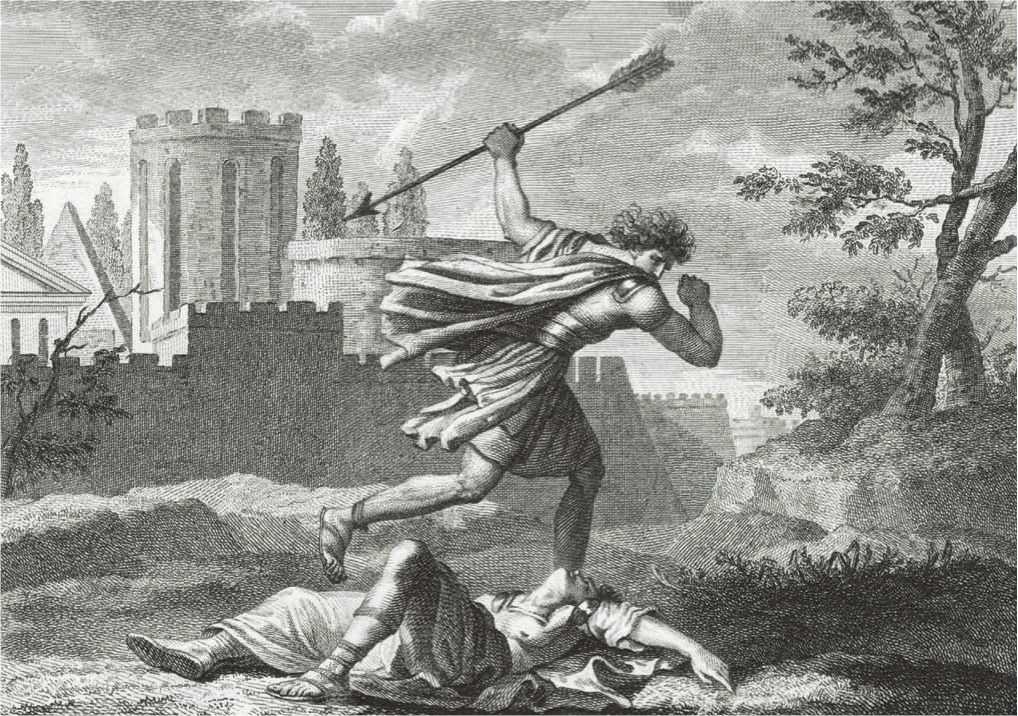
44. Although the project does not seem to be built any time soon, given both the utter absence of transparency of the process and lack of plans to move beyond prototyping–it needs to be continually recreated in performative gestures. Indeed, only such gestures can affirm, and manufacture a need, given a continued lack of consensus as to its effectiveness to secure the border. Should we accept the absence of any allocated fiscal means to move beyond prototyping as a evidence the wall is more of a figural conceit than an actual project? The completion of the prototypes promised to be manufactured with the existing discretionary funds of $20 million; yet none of the estimated $20+ billion needed for its completion was approved, or is expected to be.
The result is that the Border Wall far more easily mapped than built, and far more easily imagined than financed or operated–but exists as a powerful map of national boundaries. The lack of any response to FOIA requests for information about proposed versions of the wall are explained by a need to protect individual projects, but few seem viable to their creators, and many have leached so much money to refuse much of a profit for builders. And although some partly-built prototypes may provide a powerful photo op for a President who needs one rather badly, the images seem an illustration of grandeur likely only to exist as individual fragments–evidence of the stakes of proposals rather than projects that will be seen through.

Dark Pulse Technologies/via AP
The vast amounts available for building the prototypes insufficient to cover the finalists’ costs or help to advance completion of a project that was primarily introduced into political discourse, as a place-holder in political debate to map a vision of the nation. The absurd perpetuation of almost nonsensical discussion of the building of a wall–recently argued to be equipped with solar panels to cover its cost, without any examination of the costs of cleaning and maintaining such panels, or described as needing to be “transparent” the sense that wants border wall “transparency” lest drug traffickers hit passers-by with “large sacks of drugs” that might create bodily injury may only reflect his newfound appreciation for the term “transparent” as a descriptor, but suggests some considerable flexibility and newfound uncertainty to the impermeable nature of the frontier he long championed in the light of an apparent recent discovery “You have mountains. You have some rivers that are violent and vicious. You have some areas that are so far away that you don’t really have people crossing” which led him to revise the project from a truly fetishized image of sealing off the 2,000 mile border to only a stretch of “700-900 miles.”
45. Yet if the Wall is to remain necessarily incomplete and unfinished in actuality, it has successfully created a cleavage through the nation, and one that has been able to perpetuate an increased insecurity among all immigrants, if not also providing a justification for many “rogue” border agents to take it upon themselves to discourage or deny entry to those immigrants seeking asylum to escape political persecution or violence, and as such violate international law–as the construction of a barrier that is planned to be in Mexican territory, the imperative to build the wall seems a desire for an authoritative mapping of the border between the United States and Mexico able to demonize migrants who cross it, and indeed to erase their stories or individual histories of “unauthorized” migrants by reducing their migration to the violation of a law, measured by traversing a line, rather than their search for a new home and way of life.

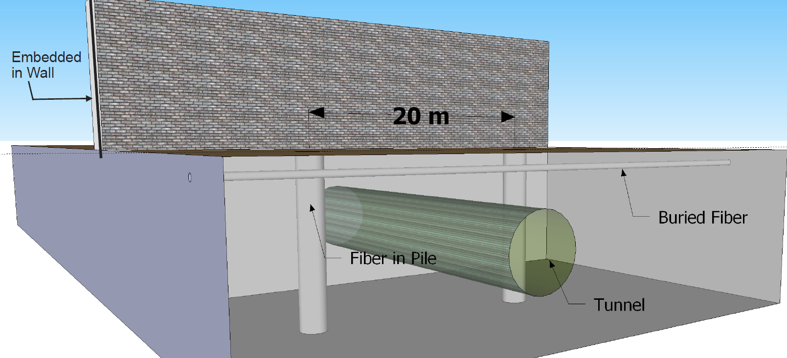
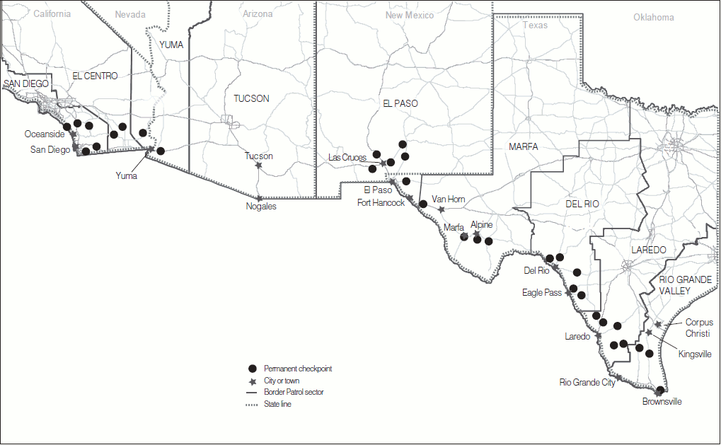
The need for such a wall was perhaps never more clearly suggested than in the “gaps” of fencing and indeed of the thirty-two permanent border checkpoints that have legal authority to patrol areas near to the border define a logic and landscape of apprehension on the southwestern border, but appear to be full of holes and possibilities for evasion.
U.S. General Accounting Office (August, 2009)
Indeed such maps, while not incorrect, have been disseminated to suggest the need for creating the border as its own authority, and as its own heightened zone of policing, as if it had an authority separate from the state, to seal off the nation from immigrants and ward off the specter of illegal border crossing.

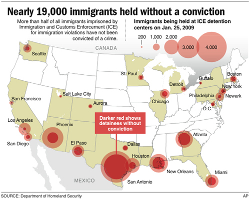
The landscape of incarceration that is located around or near the border presents an image of inherent criminality, and indeed seems a surrogate for the criminalization of cross-border traffic and immigration–of “crimmigration,” designed to reject Obama’s previous policy of “Felons, not Families,” as the targets for deportation, by the broad criminalization of undocumented immigrants, for whom the attempt at immigration is cast as the crime. They seek to cement the alliance between immigration authorities and local police, moreover, and of criminal law enforcement, rather than the legal protections that applications for asylum or immigrants need to be accorded: the criminalization of immigration is at its root a denial of rights, and a stripping of the rights of immigrants in the name of the state, but even more of a political theology and religion of the state that views all undocumented immigrants as suspect.
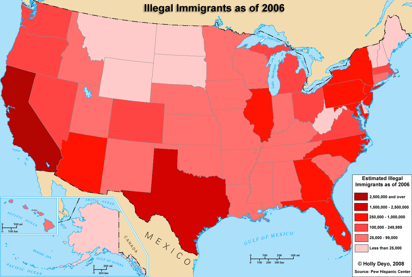
–and indeed streams of immigrants, colored red to connote danger signs, arriving to take up residence in the United States in various states of alarm, danger, and a need to respond–as well as a sense of an unstoppable “stream,” shown here if a ridiculous primitive visualization, showing no sense of the actual volume of traffic by leaving that to the viewer’s imagination to fill in–in a data analysis that oddly displays its poverty of information, given the intent of the “Division of Migrant Education” to restrict immigration.

Yet what is a wall or a fence? Whille fence was the operative word and powerful construction of the spatial imaginary, the The Boundary Wall Trump proposed conjured an antiquated notion of the fence–not at all as in “good fences make good neighbors”–but it went deeper than a fence, and didn’t carry any sense of neighborliness. It recalled, rather, an archaic sense of the noun as a means of national protection, and as an exclusionary boundary, as a verb as providing a defense.
The origins of such a wall that trumped the law, and was defined around the religion of the nation, might be, paradoxically, be seen within the excavation of the development of codes of law performed by Enlightenment jurist Giambattista Vico, who saw in the wall a powerful precursor to the law: in his magesterial eighteenth-century Scienza Nuova, Vice surveyed a monumental history of civil institutions that attentively traced the evolution of languages in different periods of civil government, the Enlightenment legist Vico placed importance on the plough as a basic tool of civilization that delimited the foundation of cities, by carving of a line in the fields. The line drawn by the plow was a definitively marking emergence from nomadic life, for Vico, constituted by the very act of inscribing it in the earth, and a fundamental act of literacy and human invention that led to the foundation of laws, and indeed of human society from an era when man had wandered in the forests.
Building a wall is a pre-legal bounding of limits of property and provides a necessary foundational moment, a “bloody” precursor to the civil state in the early Roman world. If Vico mapped philological origins of such boundary-drawing as a site of primitive fortification as predating legal institutions, in odd contrast with the championing of the legal status given to the Border Wall as a threshold of the legality by the founders of cities who circumscribed the urbs in ways traced by the plough: these walls were the most primitive form of writing and division of lands traced by founders of cities, before the civil law, that “bloody ceremonies had consecrated” [550]. The Death of Remus, the co-founder of the Roman Empire, on the walls of the Palatine where was refigured as a foundational act of the ancient republic in Vico’s works, a moment of the foundation of the republic that preceded and was as important as its laws–a moment that was commemorated in images designed at the time of the French Revolution by a student of Charles LeBrun as a decisive moment of civilization, in explicitly dramatic ways, a bounding of civilization on one hill of Rome–the Palatine–marked by the sacrifice at the walls around Romulus’ city of his fellow-twin who had once suckled at the same she-wolf. Based on their different interpretation of auguries, the story of Romulus killing Remus has led many traditionalists, nationalists, and members of the alt right to be drawn to the violence of this founding myth, and indeed made it central to discussions of national identity and tradition, even as it evoked a purity of nation in ways that has rehabilitated and affirmed, if also being oddly silent on, its fundamental violence. If Roman historian Livy wrote both “Romulus and Remus were seized with the desire to found a city in the region where they had been exposed and brought up,” leading to an escalation of violence in which Remus was killed, the “commoner story” of how taunting led Romulus to slay his brother with the fateful words, “So perish whoever else shall leap over my walls!” has led the moment of violent sacrifice to link fratricide and founding, as a moment of cleansing and a symbolic, as much as mythic, foundation of the national community in blood that affirmed the sanctity of the walls around Rome and conferred identity on Romulus as its sole founder, tied to the protection of property rights and preceding the adoption of a legal code.
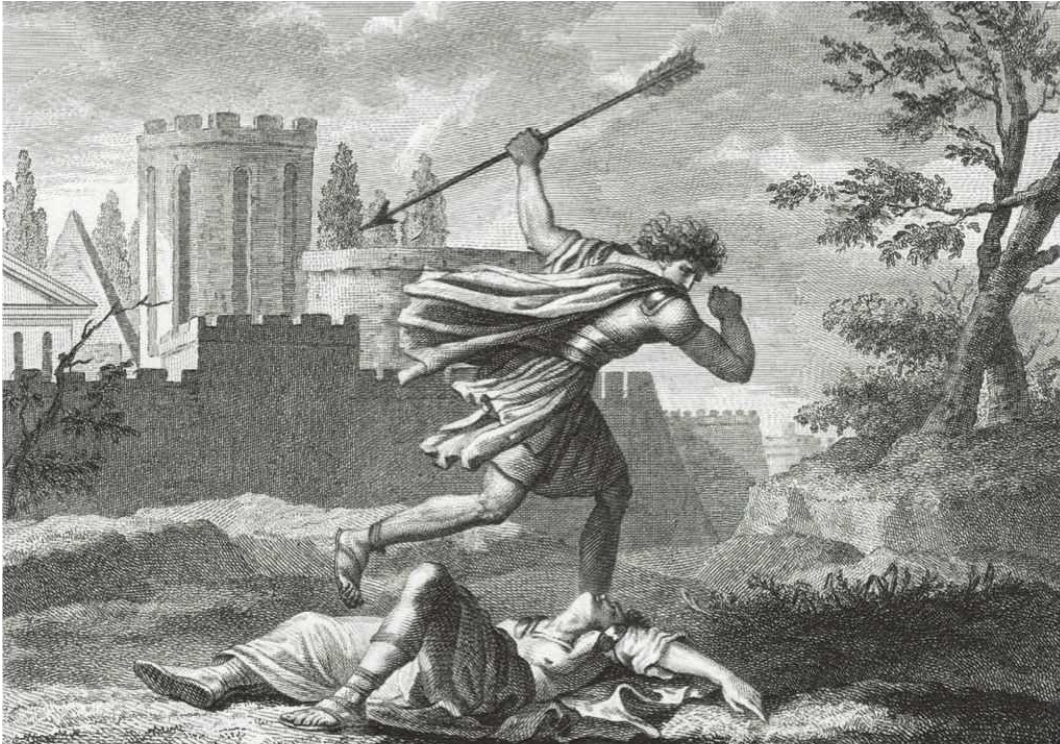
Donald Trump’s border wall consciously recalls a difference of blood–an almost radicalized difference of nation, kin, and family–that separates the state, and combines it with the invented nature of the boundary line that was constitutive of, as much as an artifact or product of, civil society. The declaration of the wall recalls in its imposition of authority the ceremonial staging of Remus’ murder at the wall, as a historical moment of fratricide which is both conducted outside the law and outside of natural law, as it violates international law and human rights law, but is staged as something that occurs for the need of the nation–natio–and affirming the birthright of the nation above the right of Remus to live. The very extra-legal nature of the construction of the wall that Vico defined–a construction that is not based on written tradition, but precedes it, is rooted in the act of sacrifice. If Vico saw this as a foundational legal moment, the myth of the “citizen” and Roman citizen as being “born from the land,” as Romulus, suggested a model for the custodial relation to the wall built around the Palatine, as the truly privileged foundational site of the nation–protecting a sense of property rights and indeed a “citizenship” law.
It is bound together with Trump’s cultivation of the uneducated–“I love them! I love the uneducated!”–as a defining of the true nation, excluding those beyond the inscribed boundary wall that defined the nation, even if undermining of the law and disrespect for legal institutions. Both the President and his own Attorney General place the constitutive role of borders above the law in defining the nation, in a primal sense, beyond the written document of the constitution, as if echoing the defense of that the border of Mexico long assumed in the Tejano imagination and the Republic of Texas, against the figure of the “illegal” migrant, who is figuratively if not literally slaughtered and sacrificed on the border wall. The moment of the foundation of Roman power, a focus of admiration on the alt right and white supremacists, is tied to the “remaking” of America, or refoundation of its order.
36. For the success of its violence against immigrants affirms its semblance of sanctity to the nation. Its violence on the prospective undocumented immigrant serves to deny the tradition-bound basis of such a wall in the law, or a legal tradition that is removed from human making. Indeed, rather than exist in a tradition of the nation, the notion of a southwestern boundary was made in maps, not existing in the ethnic composition of the actual areas of western states as a fixed line–as if to separate those who are now understood as of different blood, rather than similar groups. The expansion of the “border zone” far from the actual border has invited guardsmen without training to perform law enforcement functions described in section 287 of the Immigration and Naturalization Act (8 U.S.C. 1357).
Less than a reflection of actual difficulties, it seems a rewriting of the boundary in blood, whose expansion reflects the adoption in so-called Immigration Reform groups in border states adopted the term of “criminal alien” as an expression of criminality for undocumented immigrants, whose prominence among states-rights activists and nationalists blurred the and encouraged baseless allegations of criminality to be invited in a big tent of disenfranchisement and denied civil rights, cutting sharply against the grain of civil society.

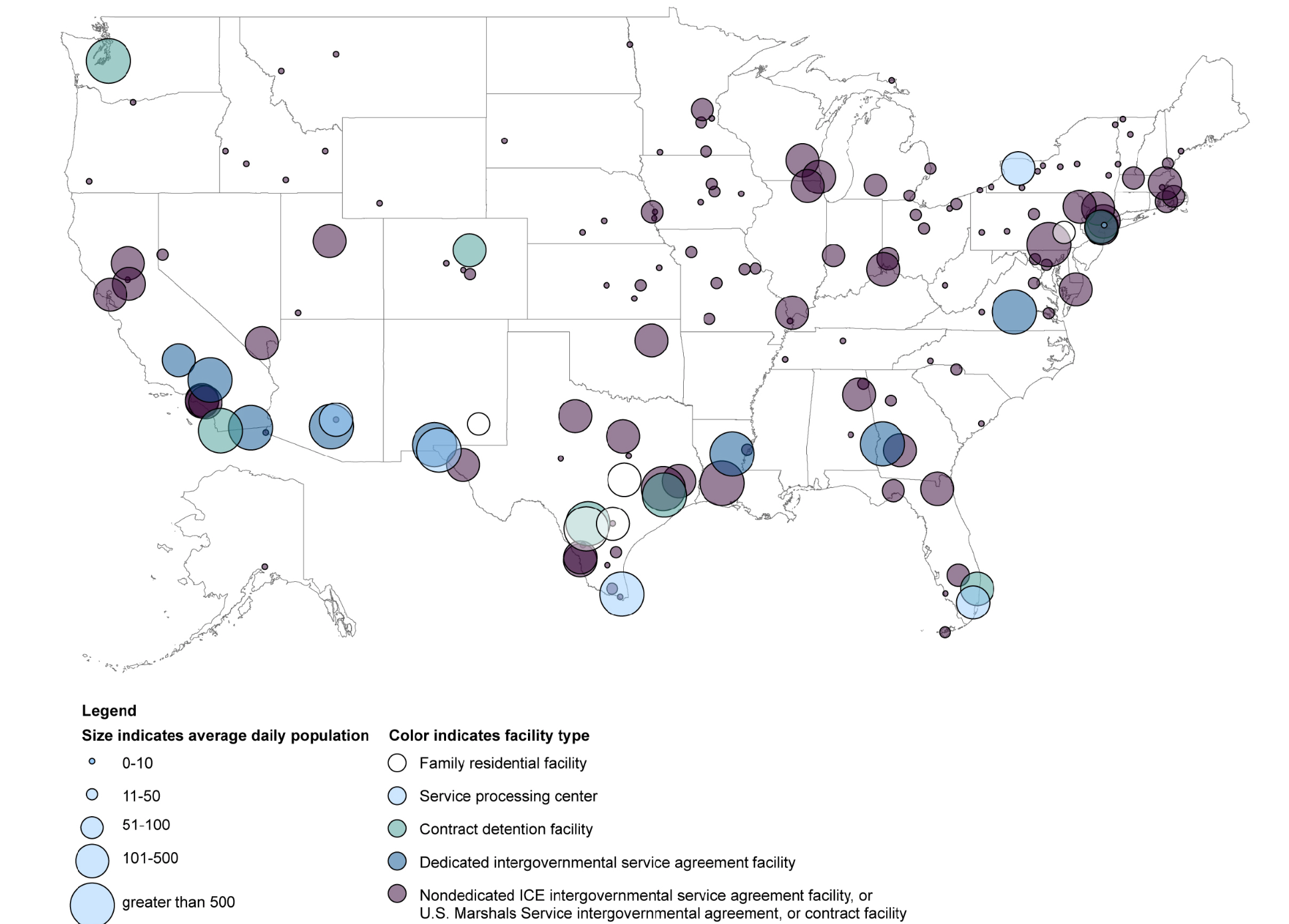
ICE Information on Detention Centers in 2015, analyzed by GAO-16-231)/GAO Blog


ICE Detention Centers, 2017 (by operators of detention centers)
The invented nature of the wall is historicized as a defensive act rooted in blood–and that marks the differences in blood that the US-Mexican border wall creates. Vico’s observation of the origins of walls, moenia, with the earliest form of fortification–the Latin word for ‘walls’ is moenia, a variant of munia; and the verb munire kept the meaning ‘to fortify’–of pre-legal status. The sharp contrast to defining the border wall as a legal threshold with the criminalization of immigration reminds us of the extra-legal origins of boundary-drawing, despite its increasing power as a threshold of the southwestern boundary.
Much as Vico has described the early creation of a wall around Rome as fundamental to its unity, but a crude metaphor for unity that predated the commonwealth or republic–or popular liberty–as walls traced by the first founders of cities by the plough, and consecrated by the blood of those who transgressed them–as the founder of Rome Romulus, who had consecrated its city walls by the blood of Remus on the walls of the Palatine, where the former had founded Rome. The decisive fratricide was a primal sacrifice to the nation, dedicating the blood of the brother who failed to recognize their authority and attempted to jump across them. fi the story of Romulus’ attempt to cross the wall of the city that Romulus had built was mythic, the death of the brother became a foundational moment of violence that was identical to the foundation of laws in Rome. Remus’ blood was shed to confirm their “so-called sanctity” [550]–an unmasking revealing the made or constructed nature of the wall as a barrier on the urban periphery. If the very “building of Rome” is dependent on the slaying of Remus on the wall, in the “Year One” of Rome, it is both a sign of the birth of the city and the rebirth of the civilization, along the wall, where blood is a sign of regeneration, and not of death.
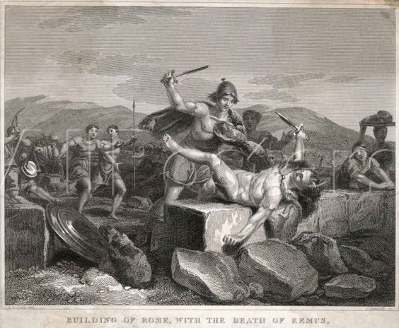
Romulus Kills Remus on the Palatine Hill: Building of Rome, with the Death of Remus/Sylvestre Myris (Paris,1810)
Romulus Kills his Bother Remus: Mort du Remus et Fondation du Rome. An de Rome 1er/Heinrich Guttenberg, after Augustyn Myris (c. 1799)
Romulus’ delimitation of the bounds of Rome was they mythic basis for the foundation of Rome–a myth that Vico would argue contained a real historical truth, not evident to the reasoning of those who failed to understand the manmade nature of history. While the Border Wall is hardly natural, it is inscribed in the landscape with a violence that is not only ecological–demanding construction in delicate ecosystems–and inhumane, but does not need a legal rationale. It seeks to be a foundational, mythic modification of the environment and by extension of political discourse. If this foundational moment is based on a fratricide, it is a mythic fratricide and a proclamation of property of the city where all are subjected to the laws.
Donald Trump would never promote the border wall openly as consecrated by blood. But it is promising a new consecration of the nation by blood, and affirming a dangerously pre-legal idea of the nation in doing so. Denying the hope to refugees or those seeking asylum, the elevation of the border wall as a needed barrier ties it to the sanctity of the nation. If there is little the tradition-bound basis of such a wall in the law, or a legal tradition that is removed from human making, the creation of a wall that replaces scattered discontinuous fence is presented first and foremost as an act of patriotism that existing border laws lack, and as able to replace the written laws of the U.S. Constitution.
Indeed, rather than exist in a tradition of the nation, the notion of a southwestern boundary was made in maps, not existing in the ethnic composition of the actual areas of western states as a fixed line–as if to separate those who are now understood as of different blood, rather than similar groups. The border wall coexists, it must be emphasized, by the expansion of the “border zone” far from the actual border. The changes in border enforcement has invited guardsmen without training to perform law enforcement functions described in section 287 of the Immigration and Naturalization Act (8 U.S.C. 1357), and U.S. Border Patrol officers to expand their abilities to stop and search within a hundred miles of the border: the border does not, in this sense, exist as a site of enforcement. The expansion of the parameters of legal enforcement of transborder travel seems to reflect the elevation of the border wall as a “real” definition of boundaries, that supplants legal conventions, in the same manner that the maps we currently use allow cross-border movement–rather than respect the legal integrity of the nation as a unit.
The border wall is less than a reflection of actual difficulties in defining a border. Rather, it seems a rewriting of the boundary in blood, as a spectacle and a show of strength whose expansion reflects the adoption in so-called Immigration Reform groups in border states adopted the term of “criminal alien” as an expression of criminality for undocumented immigrants, whose prominence among states-rights activists and nationalists blurred the and encouraged baseless allegations of criminality to be invited in a big tent of disenfranchisement and denied civil rights, cutting sharply against the grain of civil society. The proposal to involve National guardsmen to defend a nativist ideal was never adopted, but the strong interest in sending national guards to the wall as the migrant Caravan arrived suggests its militarization. The growth of border wall suggests the nativist appeal to the map as a way to distinguish lines of blood. In order to uncover the invented nature of human constructions, and eager to distinguish the made from natural or sacred authority. Vico privileged a philological genealogy to orient the universal history of civil laws in Europe in invented traditions. In his story of the made nature of institutions, neither the role of maps and indeed the tradition of boundary-marking in maps or indeed in the spatial imaginary were guideposts to his archeology of knowledge–although Vico legitimately placed significant emphasis on the transmission of geographical notions.
The border wall suggests a new stage in the transmission of notions about the border, in ways that reflect how borders, less clearly defined in maps that offer universal coverage and span distances in ways that allow borders to be fluid, provoked a new geography of state. One can only look back, at those many images of terror in which Romulus, to found Rome, kills his brother, in a famous fratricide, to find something of a mythic echo of the demand to sacrifice and expel the other taking precedent to civil law, investing a need for sacrifice at the heart of the foundation of the Republic. Or is the demand for the founding of the nation the basis for the violation of the law, before its limits are actually set? The mythic image of the armed confrontation, in which the law of Romulus is delivered by the sword, akin to the sword of justice, is not only the founding of the true national community on a different hill in Rome, but a movable myth, able to migrate across time and space. Even if the mythic encounter of the twins Romulus and Remus, armed for battle, predates the Empire as well as the foundation of the Roman Republic, its precedence allows the Table of Laws to be created in Rome, and allow order to be founded out of Chaos. And the foundation of order out of chaos is the central message of the new order on trans-national migration that Trump claims he alone–and only the new sacrificial alter of a Border Wall–can institute.

Matthias Merian, from Johann Ludwig Gottfried, Historische Chronick, Frankfurt 1619

