Tag Archives: urban ecology

Mapping Each and Every Tree

The “Central Park Effect” describes the interrupted avian migration that annually funnels a range of species of migrating birds into the trees of Manhattan’s Central Park. As they move along the great flyways of the eastern seaboard in search of a roost, the patch of trees amidst urban canyons of inhospitable anthropogenic landscape seems an area with something like habitat, whose edges offer a target to rest on a flyway that, by the time it passes the northeast Atlantic, is nothing if not overbuilt. If the park long held the space for repose on promenades and staged wilderness, birds have made it a home, amidst the anthropogenic landscape of the eastern seaboard offering far fewer and fewer roosting places during migration, recognize the park’s arboreal density as the last place to stop on a long trip north.

For the urban resident, the interruption is idyllic: the refugee from rural New England, Frank O’Hara, drank up the urban landscape he arrived in 1951, through his death, in ways that didn’t need more greenery than the Park offered him on lunch breaks. “One need never leave the confines of New York to get all the greenery one wishes,” he wrote, in dialogue with Walt Whitman’s poem that takes its spin from Brooklyn’s Greenwood Cemetery, while allowing that the city had made him so urban “I can’t even enjoy a blade of grass unless I know there’s a subway handy.” As O’Hara exultantly catalogued the hidden space of New York’s landscape, inspired by the movie houses, Manhattan Storage & Warehouse Co., and cavernous subway, the Park’s trees were enough, but also suggested about as much of the rural that he could stomach in his urban aphrodisiac that was the city that was the “center of all beauty.”

If the early trees planted tin the carefully landscaped arboreal island was hardly bound by built space, and wasn’t really an island, but modeled after European beaux-arts parks, filled the settlements of squatters in upper Manhattan–Irish pig farmers; the African American Seneca Village; gardens German immigrants presided over–with a monumental space of curated trees, whcih a hundred years after its founding had fallen into some state of delapidation, as huge towers surrounded its walled perimeter.

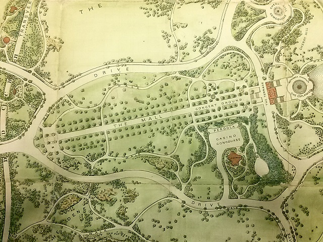
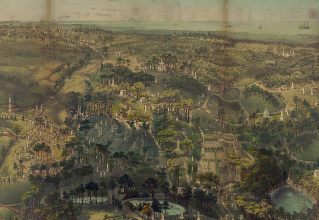
Few thought to catalogue the trees that now populate New York’s Central Park, the tide has turned. Back in the mid-nineteenth century, the expansive 1859 fold-out Visitor’s Pocket Guide to the park’s principle ponds, opened a prospective on the newly wooded regions of the park, taking time to caution visitors from disturbing the picking of any berries or flowers, as if it were a site of nature, lest they disturb any “construction, tree, bush, rock or stone.”  Its trees appear carefully situated in rows, and planted beside promenades, in stark contrast to the arboreal density today. The expansive seven-sheet fold-out map was probably based on the original pen and ink design drafted by Olmsted and Vaux as a proposal for an open, recreational space in the city, the Greensward Plan, with many paths not yet constructed and others eliminated by the time it opened in 1857, as a truly bucolic space for strolling, rather than the wooded enclave that the park has since become. The product of human work of construction of some 5,000 laborers–a miniature army responsible for paving, bench-making, constructing tunnels and bridges, lighted electric lampposts, and wiring, as much as planting trees, the luxury of the park displaced the squatters’ shacks that filled the region between Fifth and Eight Avenues, bound by 59th and 106th Street per the City Council’s mandate. But trees were hardly the planners’ main intent in imagining what they called a democratic greenspace, a curated wilderness that might substitute for the dilapidated sites for squatting of the unhoused on the then-margins of urban life: the promise of a “life in the woods” was built just three years after Henry David Thoreau had waxed as a tranquil remove from urban life in Walden (1854) would have been realized in curated fashion as a sense of “wildness,” if not of lake-like reservoirs, that urban residents fortunate enough to live near to could retreat.

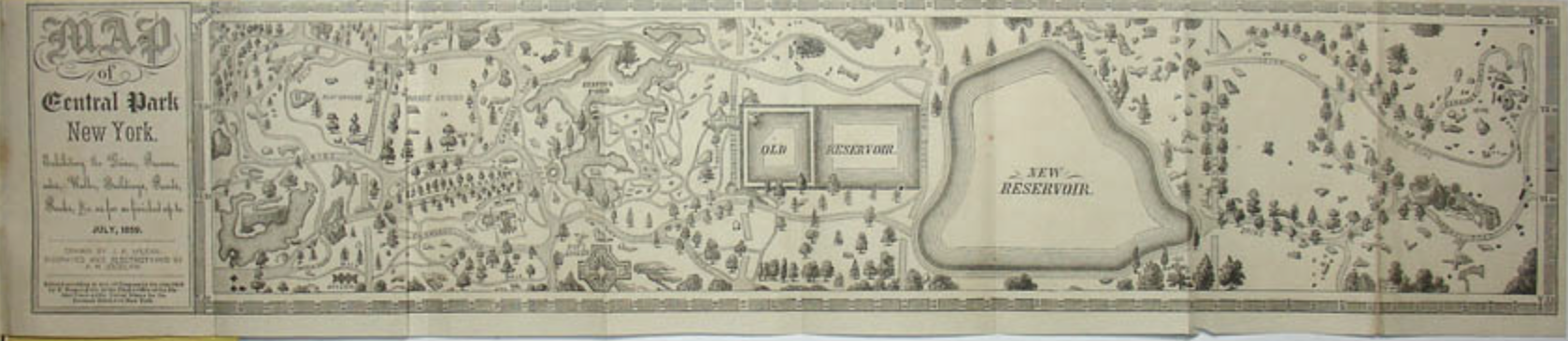
Map of Central Park New York. Exhibiting the Drives, Promenades, Walks, Buildings, Ponds, Rocks &c. as far as finished up to July, 1859 Courtesy George Glazer Gallery

The process of the planning and planting of trees proceeded by the time of the detailed lithography that Lewis Prang seems to have copied it in a form–“thin paper to fold, heavy paper to frame”–he hoped to distribute among realtors of surrounding lots, revealing a park whose “every tree and bush, as well as every arch, roadway, and walk has been placed where it is for a purpose,” as Olmstead boasted, a space urban residents might wander removed from its grid, as if to find pastoral respite from the density of urban lives. The German-American engraver Lewis Prang who desired the work, who began a chromolithography practice after emigrating, later finding notable success in chromolithographs of maps of Civil War battlegrounds, including maps able to be interactively annotated by blue and red pencil to trace the progress of armies, completed this “picturesque guide through the whole Park” in June, 1865, as what must have been a celebration of peace-time, printing it in full color only some weeks after Civil War hostilities had ceased.

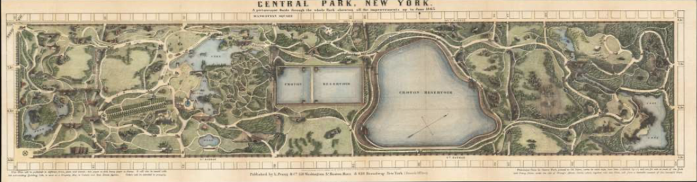
Central Park, New York. A Picturesque Guide through the Whole Park, showing all the improvements up to June, 1865

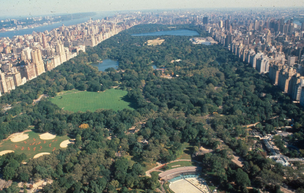
How to call attention to the variety of trees that have come to populate that unpredictable planned green space of Central Park, to catalogue its rebuilt pastoral? If the park was long seen as a site of danger in my youth, long a nocturnal site of cruising and unplanned encounters, the park planned around the Central Park is lauded for modeling the abundance of urban nature as if in negative to the built space of surrounding skyscrapers that roost around its edges.  

The way we map the park on the subway, indeed, suggests it is somehow magnified as a needed refuge for those to remember as they are coursing in cars that rumble on tunnels underground, far from any sense of open green: if the park is magnified in the famous transit map to afford a greater legibility of the tangled web of midtown lines that twist like branches or snake like roots of the circulating urban collective, it is important to remember that its lakes exist, even if its trails need hardly be mapped for audiences orienting themselves to public transit routes. We map the park, whose green provides a pause and respite from the grey concrete facades of buildings, as well as a site for strolling, by a flat lime-green interruption of the urban grid in our public maps, as if the park was an abrupt interruption of the tan city blocks, cool blue ponds creating a shared space of reflection in a landscape dominated by private property and expensive residences. And there is a sense of lack, perhaps, or wanting, that the cartographic silences of that pea-green space open, like a yawning opening traversed by busses along curved horizontal line, set apart from the urban grid.

IMG_0436

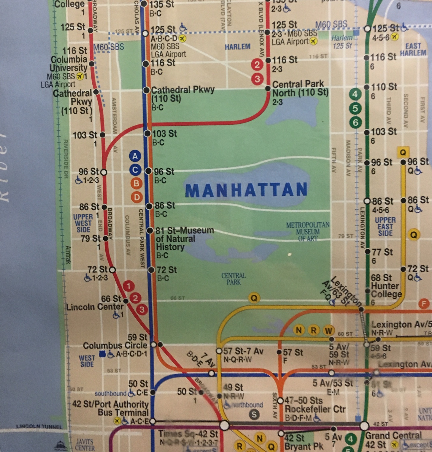
The subway map affirms, in a weird remove from the rider who is traveling underground, a removed oasis of sorts, ringed by a tan frame of muted buildings–as if a place to experience wilderness, or a curated sort of wildness.

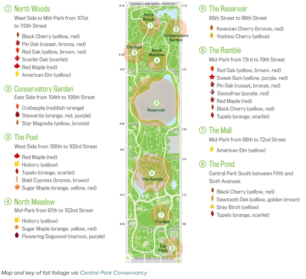
Created in the parks movement that redesigned urban space removed from unsavory elements and moral lassitude, and restored as a reprieve from the pace of urban life, the rebirth of the parks as open green-space has recently occasioned the first complete census of individual trees, those often uncounted inhabitants of Manhattan island. And each tree has been mapped, in recent years, to allow one to voyage through the space of planned trees, migrants, and recent arrivals of conifers and other volunteers, joining the staid oaks, elm, and London Plane tree.

The trees have been counted in Central Park, unpacking this light green space in an enumeration or ‘green census’ cartographers Ken Chaya and Edward Sibley Barnard created.  The result is a deeply ethical way of directing our attention to urban space, in a comprehensive map of the tree space often rendered as a stretch of undifferentiated lime green.  Indeed, the counting of large-trunked oaks, maples, individual pines, and sturdy sycamores in all their varieties offers a detailed abundance that is rarely evident in the parks maps that adopt a single cool shade of idyllic green, and offer a sort of palimpsest that will reward map-readers to pause over, examine, and explore–and indeed pore over, with the botanical level of detail and connoisseurship that the earliest planners of the park might well have appreciated and enjoyed–if not expected of city-dwellers.

Who wouldn’t have expected as much from urban sophisticates?

image

Map of Central Park: printed for the Department of Public Parks, 1873 (detail)

Yet today, the often-internalized map of the park of light green, far more familiar to all city-dwellers, may risk perpetuating an alienation from its dynamic urban forest, and obscuring the careful level of its botanical detail, or the accumulated palimpsest of urban habitats of its biodiversity. The vivid light green of most maps of Central Park may be muted, but seem rendered almost life-like in the rain–even if green is a generic “greenspace” it is one to be valued, and walked around on its circuitous paths, a space that is a distinct interruption of the equirectangular grid of the built city, and a respite from its straight lines and sheer heights.  One can see not urban canyons, but the sky.

Green aPark

In part, the duality of Central Park as rural and urban captures the hybrid identity as an urban park.  Even though the park seems to lie somewhat incongruously at the very center of Manhattan, as if the apparent preserve of trees and urban wildlife is defined by its porous relation to the urbanized setting of the park.  If Central Park was designed in the movement of urban greening and public space, as a site of health and interruption of urban life, the park is increasingly more of a heterotypic combination of urban activity, designed built spaces, and manicured wooded areas, a refuge where Manhattan is in a sense perpetually present, not only bur urban sounds, traffic, and lifestyles, in a dyadic relationship that seems captured by the fact that it offers not only the sole open space to inscribe the toponym of the island in subway maps.

In such maps of urban transit, it may be that Central Park acts less as a park, than it serves as a totem of urban space; the park holds the bold-faced word “MANHATTAN” that identifies the city, its flat green spaces and clear light blue lakes crossed by ribbons of white roads, indicating its nicely settled position as secure in an urban grid, as if fastened by crosstown routes, yet readily available to urbanites at multiple entrances as a site of repose.  The image of the interruption of urban space we encounter on subway cars with regularity reminds us of the existence of open green space which we can access, even while we ride in eardrum shattering rumbles of subway cars coursing on old tracks while winding one’s way downtown to one’s destination.  Is it an important reassuring reminder of the existence of open spaces that are in fact accessible, even while we may not feel it, nearby?

IMG_0436

The combination of nature and skyscrapers was a unitary construction, several ecopoets have observed, a conundrum or urban nature explored by ecopoets who take up the gauntlet that the urban spaces throw down.   When the poet Gary Snyder described his arrival in New York City, he evoked an ecosystem blending nature and culture that began form its trees and moved settle throughout the island’s sidewalks, streets and skyscrapers, even as it clung to the edges of its shores.  

John Bachmann, “Greenwood Cemetery, near New York” (1854), and detail

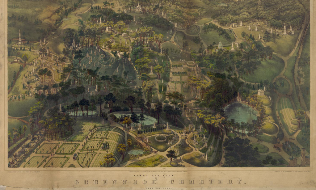
If the winding paths of the park were built as a space of democracy, modeled after the popular Garden Cemetery Movement of such exemplary success in the creation of Greenwood Cemetery as a preeminent public space of trees, winding roads, lakes, and monumental graves in Brooklyn–the trees and wooded regions central to its appeal.

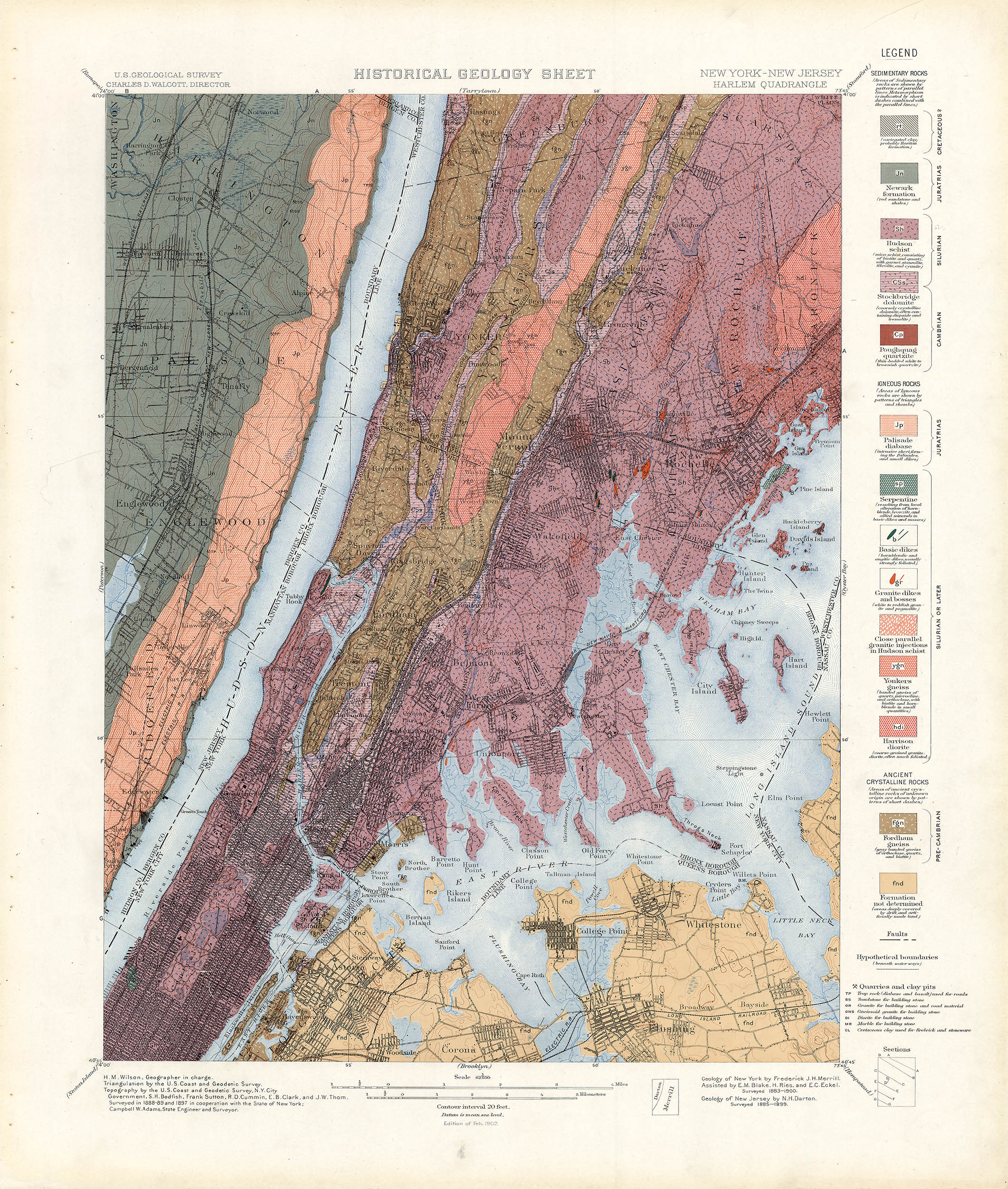
The sense of the showcasing the green space of the park had declined considerably, of course, by the 1980s, when Gary Snyder admired by the crowded built environment of New York as an ecosystem–or rather as a “deep ecology”–in “Walking the New York Bedrock,” careful attending to the juxtaposition of its trees in the steel skyscrapers of its overbuilt financial hub. The ecosystem was vibrant, but removed from wildness, if oddly emulating it in its crowded urban density upon its paved grid and steel and glass towers; helicopters like insects “trading pollen,” above skyscrapers competing for photosynthetic abilities, sirens coursing through its valleys and paths of subways like lichen rooted underfund. Snyder sung the collective recreation of a lived connection to living landscapes, the Central Park Conservancy was in its early years. The dolomite and schist that provide the basis for the actual “bedrock”–the basis for the rich growth of foliage across the island, and support offered its ecosystem–resting atop a thick bedrock of metamorphic Hudson Schist, marble, and dolomite.

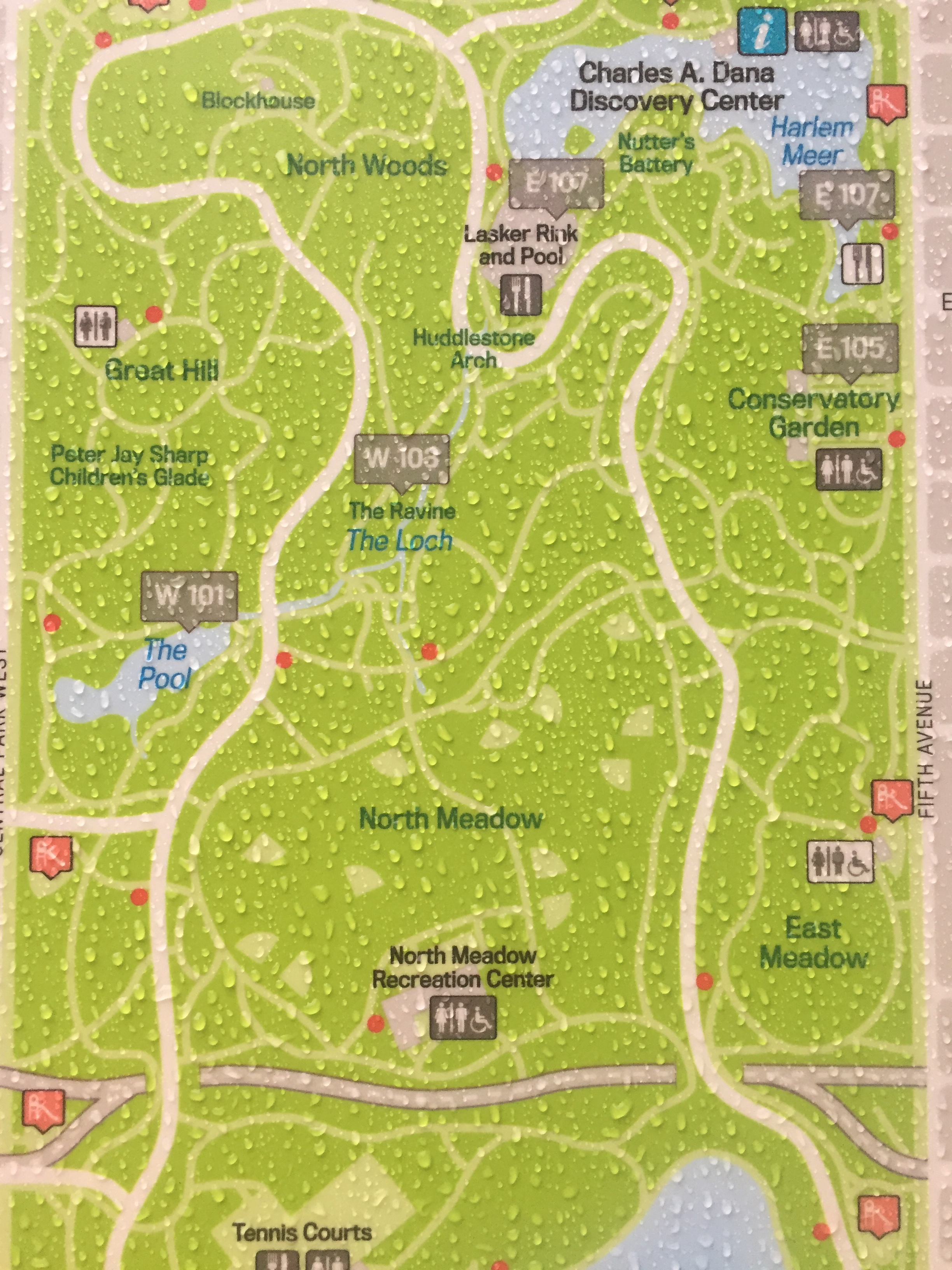
Snyder has meditated on the human relation to the built as a retraction from the wild in The Practice of the Wild (1990), which flippantly denies the vital sense of the wild in human life. Snyder wrote about the built the connection to the lived landscape that Snyder located in its wildness that remains in many natural environments was increasingly restored and retained in New York, where, as Snyder noted “there is nothing unnatural about New York City, or toxic wastes, or atomic energy…,” the trees which introduced and whose presence punctuate the poem were foregrounded in Central Park in the very years that Snyder wrote and following decades. The Conservancy has done much to call attention to the range of foliage of 20,000 trees whose foliage–Red Maple; Hickory; Sugar Maple; Scarlet Oak; Red Oak; Dogwood; Star Magnolia;–it keyed with classificatory precision–

Map and key of fall foliage via Central Park Conservancy

–to bring the space into crisper detail for us, and to attract us into its surrogate of the greater wild.

An abbreviated catalogue of a parade of urban trees–“”Maple, oak, polar, gingko/New Leaves, “new green” on a rock ledge“–are the starting points for Snyder’s urban walk on the. bedrock in Walking the New York City Bedrock (1987) that capture their dissonance with the “gridlock of structures,/ Vibrating with helicopters,” in an ecosystem populated by businessmen or by “Cadres of educated youth in chic costume,” coursing in the subways and paved surfaces under which run subways, the lichen or spiderwebs of the urban ecosystem. But the restoration of the wild within the built environment of the city are celebrated in the recent atlas of the parks trees. For they have been allowed to congregate as an interruption of the built environment, but also as an ecosystem in it.

The “park” was long promoted as the primary shared green space in the city–and a space where city-dwellers retreat, at times, to smoke some green stuff in a meadow or on a hill, the definition of the park as a set of individual trees has rarely been mapped in detail, examining the arboreal space that inheres within this interruption of the built environment–if only to excavate and explore its complex past.  For Central Park was built as a site of public promenades, a planned space akin to the popularity of the mid-nineteenth century Garden Cemetery movement that had led to the landscaping of urban areas as tranquil grounds of rest, designed within the city as sites of visitation and at a contrast from its commerce.

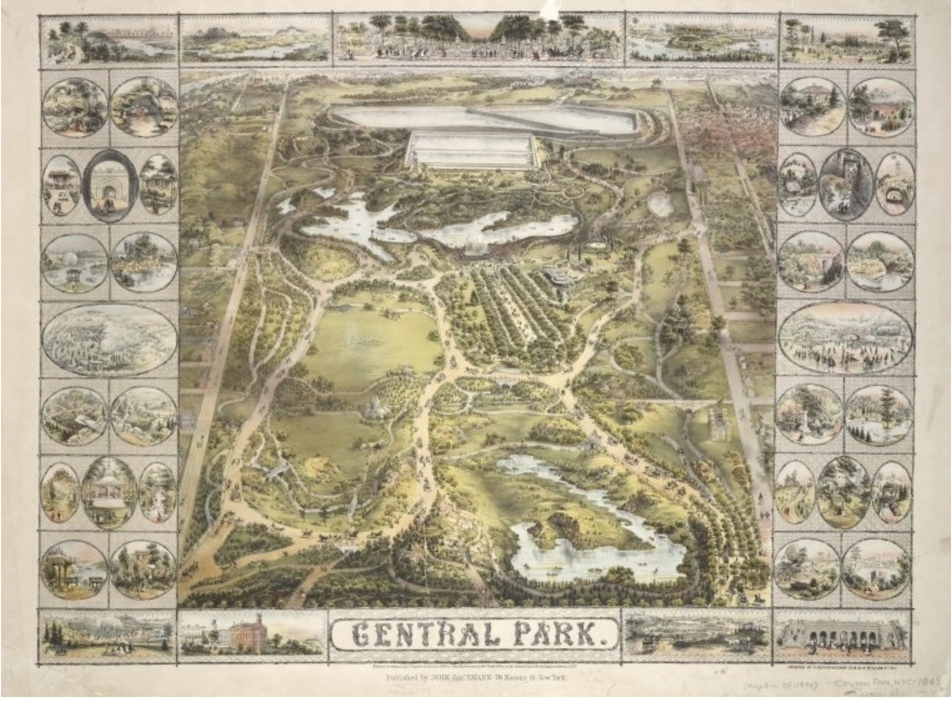
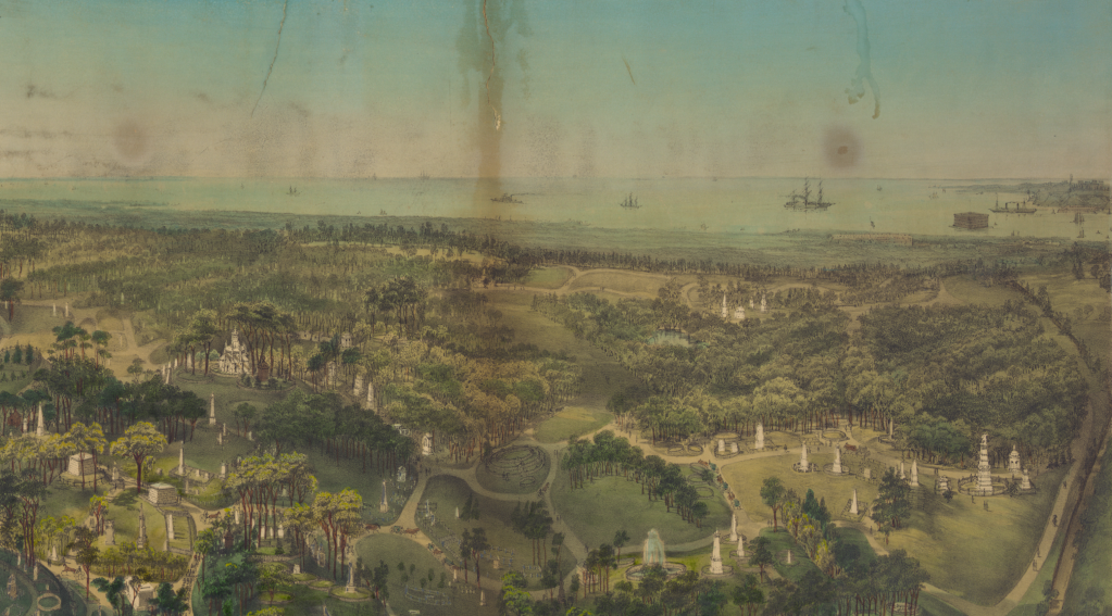
Walt Whitman, when a newspaperman, often entertained readers by the pleasures of knolls, rivers, and trees in faux rural Greenwood Cemetery that provided the illustration of Garden Cemetery in New York City by 1854, whose paths provided a sense of prospect over the harbor and winding paths, lakes, and hills among its monuments, that he inimitably exhorted all to visit, a combination of cultivated plants and open space John Bachmann crafted a perspective view in a tinted lithograph, inviting viewers to survey its planted trees and cultivated plants, as well as plains of grass and planted fields–

–that encouraged the viewer to detect the cultivated scenery of trees and plants as if to recall the praise of Virgil’s ancient Georgics to agricultural cultivation of a bucolic preserve where “in the woods the almond/Lavishly blooms so that her boughs bend low,/Fragrant with blossom,” beside where “the crops will be/Lavishly rich as well, with the great heat/Of the great exultant threshing following on.” Amidst trees burgeoning with leaves, “and therefore over-copiously shady,” the park as the cemetery would offer a place of rest, as much as work, where “Among the cultivated plants/Darnel and tares and sterile oat-grass thrive,” the overgrowth cut back with pruning knife to nurture and reveal a well-tended oak tree, juniper, cypress, spruce, willow, Linden, beech, almond, following proper precepts of cultivation to reap the benefits of sewn seeds in the properly tended imperial landscape.

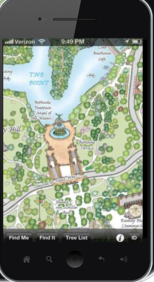
If Virgil’s paeon to the benefits of agricultural labors of planting, binding, threshing, plowing, and tending are recapitulated in the precepts of harvesting and care for the land to present a rich visual landscape in which the reader is immersed to enjoy its benefits, the range of trees, both planted and arriving by chance, have since created a landscape to be decoded by the map of each tree that the park currently contained. Drawn by hand in laborious attention to each detail, but now available as an app for easy assistance in navigating the park, the green monochrome of many maps springs to life in lists and individual detail, so that one is able to pan and zoom close-up on trees while one is navigating it.

The range of trees that now fill Central Park have been mapped by Ken Chaya and Edward Sibley Barnard in Central Park Entire, a detailed poetic catalogue that itself presses thresholds of cartographic creativity, individuating tangled ecosystems of planted trees, forested areas, native plants, evergreens and new arrivals that are mixed within its landscape, moving easily to a “tree list” that provides an easy way of orienting oneself to the multiple species inhabiting Central Park, allowing users to scroll, pinch, and zoom into individual regions and, when geolocation is enabled, to be oriented to wherever you are. Users can find the names of each of the 20,000 trees in the Park, based on Ken Chaya’s two years of surveying each tree in the park’s hundred and seventy arboreal species.

Even if the landscape was built on granite and was defined by concrete and brick, the trees defined its space, however paradoxically, in ways that capture the serendipitous presence of the arboreal variety in the city  “Maple, oak, poplar, gingko,” ecopoet Gary Snyder mapped New York’s trees in syllabic feet, “New leaves, “new green” on a rock ledge,” taking the arboreal collage on Manhattan’s bedrock as a metaphorical ecosystem, an artificial reef of the human scheme of the “Sea of Information” filled with streams of “keen-eyed people,” “cadres of educated youth,” howling sirens, and squirrels, that peregrines sail above, whose gridlock opens like a sea anemone of which wind sends a shudder that “shakes the limbs on the/planted trees” beside “Glass, aluminum, aggregate gravel,/Iron. Stainless steel.

The poetics of these long lists of urban inhabitants survey an ecosystem in a new form of rhapsodic evocation of their heterogeneous admixture of natural and artificial between paved concrete urban spaces. If Virgil praised farmers, Snyder celebrates the varieties of urban trees and pavement encountered in “Walking the New York Bedrock in the Sea of Information” (1987)–an island whose gods are capitalists, where the lavish overgrowth of plate glass windows shine beside the gleams of white birch leaves, a built and natural congeries where culture and nature overlap.

A modern Whitman, Snyder embraced walled urban canyon walked by curb and traffic light, counting trees among built space seamlessly, from ginkgo trees of Gondwanaland or built bodies to the pictographs and petroglyphs of subways, beside cable and pipe, erasing any distinction of natural and artificial, as “beautiful buildings we float in, we feed in,/Foam, steel, and gray/Alive, in the Sea of Information.” Snyder’s metaphorical recasting of the urban ecology is an ecstatic wilderness, underpinned by a tabulation of trees that echoes, in contrast of the natural and the built city how Herman Melville described the city in mid-century exultantly as “belted round by wharves as Indian isles by coral reefs,” but naturalized the built walled canyons where sirens echo streets as a built landscape where urban trees and wildlife abound. 

Continue reading

1 Comment

Filed under American poetry, Central Park, New York City, open space, urban parks

Mapping Open Waters: Bay or River?

The relation between land, sea, marsh, and landfill provided something of a dilemma of cartographical rendering in the Bay Area, mirroring the fluid relationship that has long existed between land and sea.  But if fluidity of the shoreline of the San Francisco Bay was less understood in terms of erosion, global warming, coastal flooding, and king tides back in the 1950s, the human fiction–and graphical statement–of the map of expanded bay fill provided a potent image to engage the shifting contours of land and sea.

The grassroots community activists reacted to it to protest plans for a radical narrowing of the Bay, whose success created the first inter-city compact for shoreline preservation with broad consequence for habitat conservation in the Bay Area–preserving tidal flats, coastal marshes, and wetlands that stand as a living model for conservationists, in close proximity to the city and coastal highway–as well as a legacy of the protection of open waters.

The subsequent designation of a large strip of coastal lands as a margin including Regional Protected Areas would later cover 1,833 acres of coastal lands and tidelands from the Bay Bridge to Richmond, along eight and a half miles of coast; the removal of all hazardous chemicals and garbage from 1998 restored the seasonal wetlands that were developing atop landfill in the seventy-two acre meadow, which was restored for $6 million over five years in a model to protect habitat and open space, as well as restoring a protective barrier of coastal wetlands that has long helped to protect the shoreline and bay. But the buy-in of 4,000 stakeholders in the multi-year project of habitat restoration and native habitat types however began from a protest map.

The complex bayshore that bridges four to five individual cities in the East Bay presents a complex picture of landscape and shoreline preservation and conservation, one whose sense of wonder and interest was in fact fought out in maps: if the mosaic of shoreline restoration, habitat preserves, parks, and greenspace that dot the coastline of San Francisco Bay between Oakland and Richmond offers a unique way of respecting open space on the margins of developed land, offering a landmark constraint for building out into the bay, the battle of visions for bay conservation were very much waged out through how mapping redefined the individual’s relation to local space and the world.

The story of coastal preservation that has often been cited as a model of a broad range of stakeholders began from a map. When the Save the Bay organization was formed by an improbably interested Berkeley patricians and Sierra Club members to prevent the waters from development and city housing that proposed building out into the bay in the post-war period. The military engineer John Reber drafted a plan that would reduce the bay dramatically, eliminating wetlands by adding landfill West Berkeley into the San Francisco Bay, in a monument of post-war engineering. The project of landscape modification bore all the hallmarks of modernity, and would have dramatically shrunk the bay’s open water, as much as open space, narrowing them by a massive fill to dramatically shrunken size, as well as the expansion of shipping lanes in Marin and Sausalito, that would have altered the Bay Area.

Proposed Barriers in San Francisco Bay (Reber Plan)

The triumphalism of the Army Engineers seemed almost to unite the U.S. Army bases in Alameda as a guideline to shape a modernistically sleek shoreline, punctuated by shipping corridors the open waters would accommodate. The expanded plan identified with Reber and the Department of Public works was announced quickly in the postwar era, as a massive project of infilling tidelands for a deepwater port, airports, and military bases by 1949, that would imagine an expansion of greater pierspace and nautical traffic in a Bay Area that seemed poise for financial growth as a hub of trade, as well as military outpost, expanding an “industrial site” in the smaller cities of Berkeley and Richmond, now equipping them with a airport terminals and a permanent Naval Base, and a Torpedo base in Hunter’s Point, expanding the military presence in northern California far beyond the military base in Alameda.

Reber Plane for a deepwater port, airports, and military bases (1949)[1580 x 1224]

Although the proposal for a contraction of the open waters was set as a landscape view, as if to naturalize it within the scenery, the 1949 proposal attracted heightened possibilities of greater infill that led to the reduction of the San Pablo Bay after its development of a massive landscape intervention for ten years that is rightly included among possible destructions of San Francisco by overdevelopment, even if it would have impacted the entire Bay. But the proposal for subdividing and radically reinventing the San Francisco Bay and bayshore as a basis for further development came to a rather sudden halt after over ten years of expansion, stopping in its tracks the promotion of a a modernistic streamlining of bayshore and bay waters as sites of economic development, as the plans were adopted to proposae an alternative model of conservation.

The questions about conservation that were posed at the local level on the East Bay mounted a staunch opposition, applying pressure as it coalesced through the compelling rendering of an alternative map, questioning the public commitment to a new level of landscape change and leading to a sense of reckoning about bay waters. The logic of remapping the plans of development, and the effectiveness with which a map that posited the problems and dangers development posed, however won buy-in from multiple stake-holders–now exceeding 4,000–of huge consequence.

1. What allowed the revisioning of the Bay’s open waters to be preserved? The Reber Plan would famously attract condemnation as an artificial reduction of the open waters to a shipping land, the power of the map in mobilizing resistance suggests an episode of cartographic creativity as much as public mobilization.

But the very possibility of local resistance to such rebuilding preservation of greenspace in Tilden Park had no doubt provided a stunning achievement for the Works Progress administration, allowing land procured from East Bay Municipal Water District to be converted into the East Bay Regional Parks, in one of the great New Deal projects of land conservation, leading to a decade of landscape transformation across 4,300 acres, the potential of converting lands by the precedent that invited residents to explore the local greenspace must have provided an encouragement to the preserving the bay. And the cartographic celebration of the conservation of lands and expansion of East Bay parks was able to provide a powerful, and indeed liberating way to contemplate and engage the material landscape.

The luxurious relief maps created by the Civil Conservation Corps who had administered the East Bay parks through 1942, since restored, invitingly celebrated pathways to explore and navigate the greenspace in plastic form–made during the 1930s–that preserved an image of a sense of rural versus urban space, back in the days when the hills were far more green.

While the relation between the shore and bay is hardly the focus of the relief map made in the early 1930s for the East Bay Regional Parks–perhaps as a working model to demonstrate the easy linkage of city to open space that the acquisition of lands from the Water District allowed–the careful shading of the bay waters in a gradation from deep blue to the shore provided a quite detailed sense of the sensitive of land and sea that the detailing of several creeks underscores. The aesthetic contemplation of landscape was a consideration of land and bay–or demanded one, offering a rendering of the complex of open space, lakes, creeks, and estuaries as a unified whole, and aesthetic unity, that the transformation of the bay to a shipping channel–or “river,” as polemic maps of the Save the Bay project would affirm. The old piers of Berkeley’s marina was not clearly landscaped, but the shore was defined by the tracks of the railroad, in the restored East Bay Parks relief map in a model of conservation and what land conservation might achieve, and indeed the possibility of securing land against over-development, a plan accentuated by the addition of rustic architecture and monuments in Tilden, Lake Temescal, Sibley, and Redwood Parks. The monument to conservation that had become part of the sense of place contrasted in their ethos with the stark shipping lands that would have altered not only the shoreline, but the bay waters as well.

The counter-map of the Bay waters was inspired by the subsequent brutality of adding infill in the Reber Plan.

Reber Plan: Proposed Barriers in San Francisco Bay (1959)

Designed with the apparent abandon of a crayon coloring book, in order to maximize the piers for arriving container ships in the postwar boom, the Reber Plan suggested a startlingly bold intervention in natural space to accommodate economic growth, crudely imposing economic infrastructure as if saddling it on the bay. For the Army Engineering Corps, the shallow East Bay coast, and large tidal lands, beckoned re-engineering provided a plan to envision the region in terms of “areas susceptible of reclamation” by the year 2020, back in 1957; years before the Bay Bridge, the bay’s low waters seemed ideal for a long-term plan of engineering a shipping corridor from Richmond to Oakland, domesticating the bayshore to maximize its economic utility and shipping locks would contracted San Francisco Bay, in a vision of development imagined in Washington, DC, with the endorsement of the US Chamber of Commerce.

For the project of land reclamation that the Army Corps of Engineers envisioned in the postwar era were a program to transform the settlement of the Bay Area in ways that extended pathways of marine communication by shipping industries as well as the U.S. navy in areas that were long predominantly marshland, imposing a dualistic opposition between “land” and “sea” in an area where the barriers between land and sea were blurred and fluid, and indeed on which local ecosytems were dependent: the eclipse of the regions of the Sacramento River’s expansive estuary were defined by marshland, tidal flats, wetlands, and in the East Bay shoreline, especially in Berkeley, seep or wet soil that the Plan did not register or accommodate, in its premium on economic expansion and strategic development. The coastal mapping projects that the United States Coastal Service had long engaged were put aside, and the stark land/sea duality proposed a limited way of seeing or imagining ‘development’ that seemed a logic of urban expansion that ran against the ways that the conservation ofEast Bay parks ha provided an important precedent to to manage, indeed taking it in different directions than the mapping of open space had set a powerful precedent by the 1940s–and a future that they would want to resist. If a full third of the bay had been diked off, infilled and built out that radically shrunk its open waters, Save The Bay was founded in 1961 to stop the acceleration of projected infill that would severely compromise the Bay, and has survived as an ecological monitor on infrastructure expansion and one-sided plans for development that would adversely affect the integrity of the Bay. The proposed reduction of wetlands and wetsoil along the Berkeley shore became a precedent for the ecological vulnerability of wetlands and bayshore to expansion, at a time when only a small fraction–but a tenth–of the Bay Area’s wetlands remained, and almost none of its shores were publicly accessible to residents, in the manner that the preservation of parks in the hillls provided such an important precedent that led directly to the 1965 foundation of The Bay Conservation and Development Commission (BCDC) to restrict or limit future projects of adding infill to reduce its open waters.

The relative murkiness of the areas the Army Corps of Engineers projected as ripe for infill envisioned a narrowed body of water without coastal access, in sharp contrast to conservation of greenspace around the expanding city:

The vision of the massive constriction of wetlands, tidal marsh, intertidal plains, and shallow sea or seep soil marked 325 square miles a “potentially fillable bay” as if it was an area for potential economic expansion, as much as urban growth, developing the port city as a set of functional shipping channels, seeking to crystallize a notion of functionality that offered no space for conservation. While the infill would have doubled Berkeley in size, the dramatic disappearance of San Pablo Bay by a hundred miles, even if it wouldn’t have obviated need for the Richmond-San Rafael bridge, already opened in 1956, would have been a development project of San Francisco’s coast that expanded the considerable growth of San Francisco by landfill to the entire Bay Area.

The logic of development that the vision of the Army Corps of Engineers promoted publicly in 1961 Save the Bay crystallized around a cartographic revision of Reber’s map was, in a sense, a critical turning point, or crossroads–suggested by the etymology of the word “crisis”–in how the bay could be actively remapped in the face of development, more recently culminating in how San Francisco Estuary Institute has mapped past against present landscape to orient us to historical ecology of the man-made nature of the shoreline we have inherited.

Viewed a bit differently, in materials that were provided by Save the Bay, to situate the organic place of the bay within the western landscape, the rivers whose confluence runs into the Bay join waters from the Sacramento to San Joaquin rivers run to the San Francisco Bay as a delivery of sediment from the landscape, uniting the Sierra Nevada and Coastal Range in its waters.

Save the Bay

If the bottom topography of the Bay had been dramatically altered by the flushing of sediment downstream rivers as the Sacramento, sending sludge into the Pacific Ocean, the arrival of sediment may have set a precedent for the proposed addition of infill that would deliver unprecedented sediment to the San Francisco Bay’s seabed.

But the “green shoreline” of the East Bay suggested a unique biophilic resistance to the addition of landfill, preserving the sense of open waters with which this post began.

So radical was the scale of the transformation of the Bay that Reber drafted to provoke a catalyst for the collective buy-in for opposition at the start of the environmental movement. The counter-map became a rallying cry of the defense of the bay’s open water against development by the shipping industry that affirmed the defense of a privileged relation to place for Berkeley residents, shocked by the alienating nature of the expansion of the lines of old wooden docks that dotted much of Richmond and Oakland, the two largest harbors in the East Bay. The plan would have both promised economic development, and expanded housing, into the Bay, eliminating open waters by amalgamating harbors to a straight manmade shoreline that would have connected the San Rafael Bridge and Alameda Naval Station, imposing expanded shipping lanes over the bay waters, that, as its effects were mapped, were realized to radically threaten habitat. The remapping of the preservation of bayshore helped radically change the perception of the water from the land, that helped to create a place where, when one walks today, the city and San Francisco indeed recede across the tidal flats.

2. The plans for developing the coastline by the addition of bayfill that would create either a vibrant port for pacific shipping industry were stayed as a rallying cry to mobilize opinion around the planned bayfill that would contract the East Bay, erasing wetlands that would be landfilled, dike or leveed for development, as growth of the Bay Area in the postwar period had already brought the filling in of entrance of the Sacramento River and five other rivers to the unique wetlands complex of the Bay Area–a lost environment that has been contracted by urban expansion and the reshaping of the shoreline ecosystem of so much of the bay, from the south Bay to the north bay to the estuary complex that framers of the contracted image of the San Francisco Bay to shipping channels that Reber envisioned took for granted as an inevitable process of development–but which we are now far more liable to map in terms of loss.

The protest to “Save the Bay” was animated by a counter-map that animated resistance that asked residents what sort of bay they wanted to live beyond. The abstract map of a landfill project of 1961 came to concretize the costs of development, and served–perhaps for the very reason that it was not detailed–to generate a broad coalition of protest against the imagined expansion of housing and shipping development in the East Bay. The printed map delineated how much was at stake in proposed coastal transformation so persuasively it became a powerful logo and rallying cry for the Save the Bay project from a new alliance of environmental groups and other stakeholders: if the military engineer’s map documented the modernistic redesign of the natural shoreline, in ways that extended the compromised habitat loss in other areas of the Delta and estuary, the convincing contrast between two visions of the bay–“Bay or River?” the map’s legend directly framed the future of the San Francisco Bay–put breaks on the continued development of much of East and South Bay. The map helped pose a simple question that asking readers to consider themselves stakeholders in a bulwark against massive environmental change in suggesting the near-apocalyptic scale of added landfill in dark black. While the story has been often told, the vital role an engineering map played in pushing back against vested propertied and industrial interests is arresting.

It was begun by a realization prompted from seeing a map announcing the future re-engineering of the San Francisco Bay, reprinted in the Oakland Tribune, and contemplating the possible extent of changes that would reconfigure the shore of an area that drains up to 40% of the land of the entire state, that prompted the preservation of its open waters. The prospect of such a radical remapping of the region’s open water–more than its shores alone–invested the planning map drawn up by the Army Corps of Engineers triggered the attention among three women over tea, contemplating the reduction o the Bay–and the beauty of vistas from their windows–against the areas up for potential expansion, that encapsulated and condensed the areas the Army Corps identified as susceptible for landfill.

The simple two-tone graphic generated a broad awareness of the region at a significant time in urban development, and helped to brakes on the inertia behind the radical reengineering of the bay as a shipping lane. The Save San Francisco Bay project that was the contribution of three women tied to educational groups and educators at the local university by marriage mobilized public opinion around the preservation as the wife of the past University President, Kay Kerr, herself “very disturbed about the filing of the bay” assembled a group disturbed by how “ongoing filling of the edges of the bay for airports, harbors, subdivisions, freeways, industrial sites and garbage dumps,” threatened to transform its open waters to a biological desert. Aptly, she calling an assembled group of conservationists and neighbors to order a meeting in a home overlooking the bay by a map of a produced by the Army Corps of Engineers calling for adding landfill that would leave “little more than a ship channel down the middle,” as she put it.

Proposed 1959 “Reber Plan” for Barriers Expanding East Bay Piers as Shipping Corridor

The City of Berkeley eager to expand to provide more housing, sought to double in size by filling in 2,000 acres of the bay shallows. Indeed, as late as 1980, the City of Berkeley hoped to expand the bay waterfront into a shopping center, resulting in the public trust over tidelands of the East Bay that preserved them from bay fill almost two decades later, in a suit that one of the first legal advisors of the Save the Bay Association directed as amicus curiae, in City of Berkeley v. Superior Court (1980) 26 Cal.3d 515, continuing to defend the bay wetlands’ integry against a defined shoreline.

The ability to stop the projected bayfill set a precedent that altered the relation of citizen groups and ecologists to the preservation of coastal habitat and parkland. The power of the rhetorical contrast between two maps of the future framed a vision of the local environment and access to a coast in an effective manner that one can forget looking out over the living landscape of the Bayshore Trail, but that provides a powerful reminders of how maps mobilize consensus and embodied the wetlands and tidelands as a features we have only more recently detected in the Bay as a wetlands ecosystem, truly far from built space.

Continue reading

1 Comment

March 4, 2013 · 11:02 am