In an age it is disturbingly familiar for news maps to place us on tenterhooks by grabbing our attention, the existential urgency of the blanket of the continent with icy arctic air was no exception. But if the images of sudden entrance of frigid air shocked most states in the union and lower forty eight, the farther one collapsed the week of freezing cold, the more one could see a clarion call for the re-entrance into the Paris Accords. It was as if NOAA visualizers of meteorological disturbances, newly liberated, were free to show the dangerous consequences of the tippy polar vortex and uncertain weather in an era of extreme climate change. Bright color ramps foregrounded falling temps in rich magenta or icy blue were almost off the charts, from the uppermost end of the spectrum in their duration–below–or in the low temperatures that were advanced–in maps that push the boundaries of expectations with urgency.
As maps of the hours the nation was plunged into subzero trace a purple cold front advanced all the way into the deep south as it spread across the continent from up north, the continent shivered under the icy blues over the mid-February cold spell. As we re-enter global climate accords, and consider what global accords can come to terms with climate change, it seems opportune to consider the alerts that remotely sensed mappings of our changing global climate chart. The chromatic intensity jarred with the familiar spectrum of meteorological maps to shock the viewer: the map challenged any reader to try to place the arrival of cold air and hours below freezing in a frame of reference, to dismiss the incursion of icy air up to the US-Mexico border as an irregular occurrence, more than a harbinger of premonition of the cascading effects of extreme weather, let alone a warning of the limits of our national infrastructure to adjust to it.
If the focus of the NOAA maps of the National Weather Service fulfilled their mandate by focussing on the territoriality of the United States, these images and the news maps made of them communicated a sense of national violation, if not of the injustice of the incursion of such unexpected freezing temperatures and Arctic air, as if it were an unplanned invasion of the lifestyle, expectations, energy policy, and even of the electric grid of the United States, oddly affirming the American exceptionalism of the United States’ territory and climate, as if the meteorological maps that confounded predictions were not a global climactic change.
And in the maps of the fall in national temperatures, as in the header to this post, the news that the nation witnessed a frozen core spread south to the southwest, almost reaching the border, seemed to shift our eyes from a border that was mapped and remapped as permeable to migration, to a map of unpreparedness for climate change, almost echoing the systemic denial of climate change that has been a virtual pillar of the Trump Presidency on the eve when Donald Trump had permanently relocated to Mar a Lago, one of the last areas of the nation that was not hit by the subzero temperature anomalies that spread across north Texas, Oklahoma, Kansas, Missouri, New Mexico and Iowa, plunging the many states we though of as “red” during the past election an icy deep blue interior in mid-February down to the Gulf Coast–as if the colors were a national crisis not of our own making for a nation that had obsequiously voted Republican, withdrawn from the Paris Accords, and allowed the warmer temperatures to be located only in the state where Donald Trump was now residing in Mar a Lago.
–that , as the week of arctic air’s arrival wore on, the newspaper of record glossed by a color ramp of low temperatures few residents southern states expected to be plunged into subzero surroundings. The color ramp they chose to chart how gelid air poured set off a cascade of events and disasters nicely demonstrated cascading effects of climate change on the nation, as the shock of low temperatures sucked the national attention away from the border, and begged one to come to terms with the challenge of climate emergencies in global terms. The frozen core of the nation was a wake-up call, re-re-rendering the familiar Red, White and Blue in faded out terms of the distorted levels of cold the nation currently confronts–the increased escalation of which we are projected to face.
The entrance of gelid air from a polar vortex poured across much of the midwest in unrelenting fashion. Plunging subzero temps hit the Texas coast that overloaded electric grids and shocked weather maps that seemed out of whack even for mid-February, as even the sunbelt of the southwest turned gelid cold as subzero temperatures arrived over a week, plunging the arctic neckline down into Texas, and almost across the southwestern border.
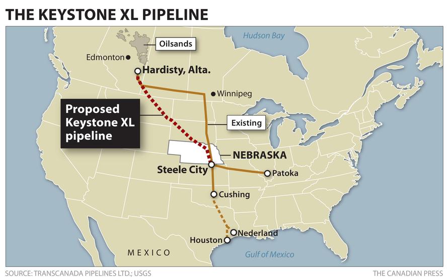
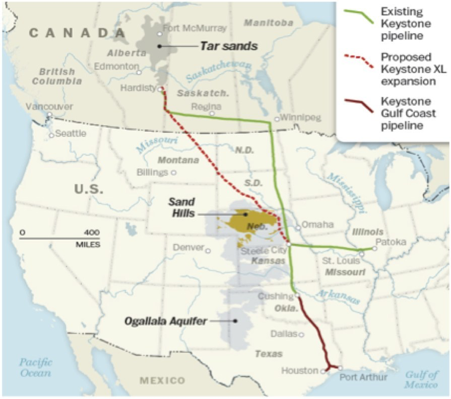
Last year the Senate failed to pass the bill to authorize the construction of the Keystone XL pipeline. But the fight was intensely waged before a map, and it seems time to scrutinize what that map charts, and place it beside what sort of future map of an energy landscape we seek to create. And as debate continues, and we look at maps to understand the potential transformation of the landscape the would result from the pipeline promising to carry 800,000 barrels of bitumen/day across farmlands in the central United States, running across many so-called “red states” of a Heartland, from North Dakota, South Dakota, Iowa, Nebraska, to Texas and Louisiana. The planned assembly of sections of this massive megaproject of overland pipe could at any point contaminate farmlands, native lands, and waterways to create massive public health risks. But we have trouble mapping such risks against a thirst for energy, and a demand for energy independence, to allow us to have access to gasoline for driving cars–even though this bitumen is refined–to petroleum products and to preserving the perpetual light blue incandescent glow of television screens.
Keystone Pipeline segments waiting for assembly in Summer Texas/Tony Guttierez/AP
Or are not prepared to do so. As we allow battles to be waged primarily I courts since a district court famously placed a permanent injunction on hopes for the pipeline’s construction in November 2018, leading the President we have to re-issue a new cross-border permit that sought to replace the previous permit issued by the State Department, under his sole authority as executive framer of the nation’s energy policy, even in the face of no plans for pipeline construction in 2019, we need to map both the benefits that the Keystone XL pipeline against the real risks it would pose. Indeed, the almost hubristic attempt to build pipeline from Hardisty all the way to Houston, in ways seems a straight line, suggests a huge amount of new pipeline that would challenge the technology we have of transporting bitumen, to provide crude for existing refineries in Houston and Galveston that falsely promises to restore their industries, even by raising risks we cannot start to fully imagine in an age of rising temperatures, increasing climate pollution, and the possibility of actual national emergencies. Even before Transcanada’s own maps, we should pause at the claimed promise of jobs and easy energy–
–especially in the face of clear alternatives, already under construction, by which the oil would be shipped for refining to Asia, at a rate that is far beyond the 800,000 barrels per day Keystone XL is designed to carry.
Alternative Planned Courses for Bitumen Transport from Tar Sands
The transport of the messy, oily, Tar Sands bitumen and slick through the proposed expansion in the pipeline would, of course, cross not only farmlands and run relatively alongside of rivers that trained to the Gulf of Mexico, but transport petroleum through a region of the largest aquifers of the central United States, as well as raise threats of the possibility of leaks into above-ground streams and rivers, which would be difficult to clean up, not to mention 2500 groundwater wells lying near the proposed pipeline, whose monitoring for possible contamination would subtract even from any possible revenues that the pipeline would create.
Harvard Bioinformatics and Genomics
But the specter of losing promised jobs, and indeed of a declining American petroindustry above-ground, long active in local and national politics, has made the fear of alternatives–and alternative energy exports from Canada–frightening to many United States Senators, even if the refineries in American waters or mainland would not be receiving the bulk of bitumen shipped from American ports, and hardly would keep them active alone.
And the recent decision to adopt measure designed to designate the built pipeline sections “critical infrastructure would criminalize any damage gas facilities currently under construction as third-degree felonies that can carry as many as ten years in prison, preventing “impair or interrupt” protests or even entrance into property with the intent to damage or disrupt to become recognized as felonies by the state of Texas–if not the second degree felonies that was proposed in an earlier bill proposed by Representative from Marshall, TX. Such bills are intended to disrupt any environmental protests against the 650-mile Jupiter oil pipeline and Kinder Morgan’s 430-mile natural gas Permian Highway pipeline, both designed to transport fuels above ground from one of the nation’s largest oil patches in West Texas to the Gulf Coast, with the intent to prevent protests of civil disobedience or environmental justice as has occurred in Standing Rock. Despite the danger of such pipelines to San Antonio’s drinking water, the rush of a boom in oil and gas production in the Permian Basin of West Texas, en rushing to build pipelines across the state despite tremendous opposition from landowners whose lands would be seized by Texas law that allows private, for-profit companies to claim rights of eminent domain: such anti-pipeline-protest legislation has been adopted in Oklahoma and Louisiana to stymie protests seen as unnecessarily disruptive, and have been overwhelmingly supported by the oil and gas industry who seek to secure their rights to construct pipelines, and cast any attempt to disrupt their construction as disruptive interfering with corporate operations, and probably disruptive the possibilities of protest of native nations as it would impose severe fines and penalties of up to $10,000.
And the recent decision to adopt measure designed to designate the built pipeline sections “critical infrastructure would criminalize any damage gas facilities currently under construction as third-degree felonies that can carry as many as ten years in prison, preventing “impair or interrupt” protests or even entrance into property with the intent to damage or disrupt to become recognized as felonies by the state of Texas–if not the second degree felonies that was proposed in an earlier bill proposed by Representative from Marshall, TX. Such bills are intended to disrupt any environmental protests against the 650-mile Jupiter oil pipeline and Kinder Morgan’s 430-mile natural gas Permian Highway pipeline, both designed to transport fuels above ground from one of the nation’s largest oil patches in West Texas to the Gulf Coast, with the intent to prevent protests of civil disobedience or environmental justice as has occurred in Standing Rock. Despite the danger of such pipelines to San Antonio’s drinking water, the rush of a boom in oil and gas production in the Permian Basin of West Texas, en rushing to build pipelines across the state despite tremendous opposition from landowners whose lands would be seized by Texas law that allows private, for-profit companies to claim rights of eminent domain: such anti-pipeline-protest legislation has been adopted in Oklahoma and Louisiana to stymie protests seen as unnecessarily disruptive, and have been widely
The debate about the pipeline was first rehearsed before a predominantly Democratic Congress, before 2014 elections led Republicans to promise to place the Keystone at the top of their Congressional agenda–in the attempt to place it on an actual map. The first effort to pass the bill was championed by a Democratic Senator from Louisiana, who vaunted the benefits it would bring to New Orleans and the Gulf of Mexico, and hoped to convince the C-SPAN public to the nation as a whole. At a time when the long-time senator felt increasingly politically isolated, Sen. Mary Landrieu (D-Louisiana) staged a photo-opportunity standing before a map of the nation: the map placed the proposed project for laying line across the US among a web of existing national pipelines, as if it would symbolize her own relation to the nation, as well as the place the pipeline within the much-vaunted promise of energy independence. The deceptiveness of the map by which she sought to symbolize such independence had of course been crafted by pro-corporate supporters of the pipeline, and its deceptiveness–and erasure of costs–needs to be examined, lest it be lodged in one’s mind.
For longtime Sen. Ladrieu, the map displayed the Keystone pipeline as a key to restore or burnish the image of America as an energy superpower. Yet it disguised the devastation of the extraction of oil or the fact that little of the oil transported was destined for or needed in an American market. At the same time as oil consumption is declining nationwide and prices are rapidly declining worldwide, Landrieu used the map as something of a backdrop to sell the pipeline by placing it at the centerpiece of a compelling, if largely illusory, vision of energy independence. But the declining significance of oil to US energy problems (or energy policy) was obscured by Landrieu’s appeal, as it will be, in the Republican priorities for the new Congress, as they make it a top energy priority and link it to the hope of “energy independence” again. Although such approval would have little effect on changing gasoline prices, and obscure that we face an oil glut, there is almost a fetishization of the pipeline as opening hope for an expansion both of offshore drilling for gas on public lands, and an acceleration of the permitting process for exploring for natural gas that have already been granted. Hortatory banner ads trumpet with urgency the enticing promise of “Leading America to Energy Independence”–and claim that that will all be done safely, with our best interests in mind.
Yet although the Keystone pipeline has become something of an entrée to the expansion of a new US gas and oil boom, and is billed by TransCanada as the “safest and most advanced” pipeline in the continent, which would offer a new “essential infrastructure” to American oil producers, despite a glut of cheap oil, by presenting the $8 billion project in a rhetoric of progress in energy policy–even though the 800,000 barrels of bitumen (or diluted bitumen) that it would promises to transport each day all the way from the Alberta tar pits to the Gulf Coast refineries would be destined for export, and would mean only 35 permanent jobs.
With no clear benefit to American consumers made clear, however, the “progress” of the bill is being pinned to the notion of creating an expanded and renovated energy infrastructure, even at the cost of expanding other serious infrastructural problems in the country. By integrating the network of existing gas and oil pipelines as a single network, the map used situated the delayed Keystone project as part of a national network of pipelines, suggesting that it would take its place within a coherent national energy policy.
Joshua Roberts/Reuters
Yet whether such an energy policy exists remains open to debate.
We read more maps than ever before, and rely on maps to process and embody information that seems increasingly intangible by nature. But we define coherence in maps all too readily, without the skepticism that might be offered by an ethics of reading maps that we all to readily consult and devour. Paradoxically, the map, which long established a centering means to understand geographical information, has become regarded uncritically. As we rely on maps to organize our changing relation to space, do we need to be more conscious of how they preset information? While it is meant to be entertaining, this blog examines the construction of map as an argument, and proposition, to explore what the ethics of mapping might be. It's a labor of love; any support readers can offer is appreciated!