In the year 2025, a seven year old girl looks up at stars against the “deep, black” night-time sky, remembering that her stepmother as a child could once not see their “cool, pale, glinting light.“ Octavia Butler sets the scene for her cautionary tale, Parable of the Sower (1993), a novel which glosses the spiritual journey of the believer by cautioning against the indiscriminate sewing of seeds in infertile ground. The abundance of light in this possible world is an increasing reality. The girls’s stepmother used two words–“‘city lights‘”–to come to terms with the radical changes of nocturnal luminescence wrought: stars grew so feint in the night sky they lost visibility in her own memory. “‘Lights, progress, growth, all those things we’re too hot and too poor to bother with anymore,’” is all she was able to explain, in a post-apocalyptic tenor increasingly haunting today’s world, as the absence of darkness seems to have rendered starlight invisible in most of an over-illuminated earth.
The memory, and public remembering of an era of over-illumination haunted many works of the era with good reason, as the world of darkness has receded into the past. Novelist Russell Hoban imagined the absence of all government in a post-cataclysmic world drowned in darkness in Riddley Walker (1980), set in 2437 O.C. (Our Count, dating from an atomic blast) but haunted by fragments of the scientific language that are shard-like memories of a world lost to “counting cleverness,” which by “straining all the time with counting” eliminated of night–“‘What good is nite its only dark time it aint no good for nothing only them as want to sly and sneak and take our party a way'”–who “los out of membement who nite wer” as “they jus want day time all the time.” Echoing current environmental concern for the ozone hole, Riddley bemoans the “harms what done in poisoning the lan or when they made a goal in what they callout the O Zoan . . . you can’t see it but its there its holding in the air we brave.” The difficulty of remembering or registering the scale of global loss, and the possibility of an absence of terms to ever know the geography of stellar visibility or dark. If the reparation of “memberment” tries to keep together a world where all government is reduced to the performance of Punch & Judy puppet shows, the elimination of night is cast as a precursor to atomic apocalypse.
Are we in the midst of a current era of the lack of remembering an era that not so over-illuminated by artificial gas or electric light? The apocalyptic nature of a loss of the darkness of the night is increasingly upon us, and long before the year 4347 when Riddley Walker appears set. For the many reliant on round-the-clock work, any border between day and night is increasingly obscured. All-night work across the world have fashioned glowing landscapes of increasingly illuminated night skies, over inhabited spaces in over-illuminated lands may redefine an uncanny materiality of maps for the new millennium, evident in composite satellite images of an electrically illuminated world.
Nasa Earth Observatory/Composite Image of the Night from the Godard Space Flight Center
The notion of a “star-gazing station” that pops up along the highway may seem an improbability today. But driving an hour and a half north from Toronto, just north of Napanee, one passes a Dark Sky Viewing Area, that offers the chance for volunteer-led star-gazing, where knowledge about viewing night skies are eagerly passed down, as if out of Fahrenheit 451, offering opportunities for amateur astronomical observation of geminoid meteor showers at the “most southerly dark sky site in Ontario,” where increased stellar visibility confirms that one has moved sufficiently away from the hyper-luminescent United States to “natural brightness” to view the Milky Way in all its glory. The designation of “natural brightness”–or darkness–suggests a growing need to reckon with the geographical limits of night-time illumination. North Frontenac, the Royal Astronomical Society of Canada assures, offers surroundings suitably dark in fifteen km in all directions to be designated a “Dark Sky Preserve Status” for viewing night-time skies as they once looked. The Star Gazing Pad invites all with telescopes in what seems a throwback to the popular astronomical observations of Victorian England. But it reflects growing anxieties and fears of the unprecedented skyglow and the augmented illumination of night time skies, where viewing stations are removed from major population centers. Astronomical observation in “dark sky viewing areas” exist outside of cities, near national parks, offering the possibility of respite from over illuminated skies.
Driving north from the border today, one arrives on the 401 in “dark sky country,” as if a definitive passing of the border, north of Kingston and Lake Ontario, removed from the nocturnal glow of city lights, which promises to provide the “night sky experience very similar to what was available more than 100 years ago,” promising visitors the chance to “witness–perhaps for the first time [in their lives]–how the night sky is meant to be seen.”
Again, the question of the geographical boundaries of “natural brightness” and “natural light” are called into question by sites of such “Dark Sky Viewing Stations,” which have grown rapidly in Canada as preserves to “save the stars from light pollution.” The United States was the foremost model for Butler’s cautionary tale of a post-apocalyptic future, when stellar visibility had only just returned, but only did after the decline of a world in which increasing artificial luminosity had long removed the stars from increasing portions of mankind.
The vignette helped situate readers in a time just after a global collapse, where villages and cities are walled from roving gangs of drug-crazed marauders, and any semblance of security or infrastructure is gone from memory, and has faded into a past that few save the old can recall. Lauren protests to her stepmother “there are city lights now” which don’t “hide the stars,” but the older woman is only able to shake her head in response, trying to summon earlier skyscape, and describe the changes that set the scene for the dystopia they now inhabit: “There aren’t anywhere near as many as there were. Kids have no idea what a blaze of lights cities used to be–and not long ago.” Lauren tries to recuperate an even earlier sill of reading the stars by an astronomy book that once belonged to her grandmother that allows her to decipher constellations she is now able to trace, and are newly visible in the night-time sky, using its maps as the sole means to be able to glimpse the stellar order seen in the night-time skies of bygone eras. Gas lighting was a memory of the past.
Henry David Thoreau pegged the confusion of night and day to the railroad’s expansion in mid-nineteenth century America, and to the expansion of the railroad outside of Concord. Amidst the spread of electricity, even in the unfrequented woods on the confines of town, traveling in th “electrifying atmosphere” “at some brilliant station-house in town or city,” Thoreau described the passage of trains as a new environment in their train of clouds and piercing whistle and defiant snort, acting as a giant plow amidst the countryside, registering the surprise with which even “in the darkest night dart these bright saloons without the knowledge of their inhabitants” as new environments. If this pollutes our language as “to do things ‘railroad fashion’ is now the byword,” the energetic coursing of the trains pollute his own senses not only by introducing light to the dark night where he is at peace: only after the train departs does he hear again the calls of whip-poor wills, hooting or screeching of owls, crying geese, or croaks of aldermanic bullfrogs of Walden, as if reacquainting himself with a natural sensorium of a living evening habitat that the train obscured. They return only after the retreat of any automated “path to the civilized world.” Far from the gas lighting that Thoreau had created a residence with “no path to the civilized world” in Walden Pond, even if it was with such a “deficiency of domestic sounds” that “an old-fashioned man would have lost his sensors or died of ennui” at the relative silence save squirrels on his roof, blue jays screeching, or a rabid or woodchuck beneath the house, finding privacy in a solitary life on a few square miles of forest, reclaimed from Nature, with “my own sun and moon and stars,” finding that even rare guests from the village “soon retreated, usually with light baskets [flashlights], and left ‘the world to darkness and to me,'” in an ideal of no light pollution that seems to have rapidly receded ever far away in time.
The night-time illumination of regions was tied to the introduction of the train. An animal of artificial invention, the train was a mechanical horse, snorting and creating a new environment of nature. Running across the countryside as a “fire-steed that flies all over the country,” a “cloud-compeller” that remakes its own habitat, stopping at “some brilliant station-house in town or city,” concealing the sun and leaving his own bucolic home cast into shade in its progress and he was awakened by its “defiant snort” in the middle of the night, erasing the division of day and night as it “penetrates my woods summer and winter. The progress of the train was, Thoreau suggested, to be weighted and considered a danger for the distancing of the world from nature, more than afford a support for civilization in the ability it offered to carry goods from all over the world to new locations, and provide odors carried with goods from “foreign parts, of coral reefs, and Indian oceans, and tropical climes, and the extent of the globe,” an effective precursor to the smooth surface of the transit of goods and open markets we tie to globalization. Concerned that there was “something electrifying in the atmosphere” of the train depot, where men “talk and think faster,” Thoreau invited readers to balance the improvements in punctuality the train provides even to farmers and the new compass lines it create perhaps obscure the path of fate in the air “full of invisible bolts,” as the individual is tethered to the relations of time and distance the train instilled.
Time Indicator, to Calculate Time Before the Standardization of Time by Charles Ferdinand Dowd in 1869
The rise of Railway Time by Greenwich Mean Time helped illuminate the landscape have accelerated to the premium on unelectrified unlit spaces of the present. In ways that give a new sense to “dark data,” techniques for mapping of the absence of light from an increasing share of the world suggest a new understanding of “place” that commands attention in multiple ways. The Bay Area where I live can already be seen from the sky from the International Space Station, as photographed by astronaut Randy Bresnick photographed it in one of his final trips about the planet, that bear shocking witness to the expanse of populated lands that illuminate the growth of streetlights in the Bay Area, where intense luminosity stretches from San Jose to the Carquinez Bridge:
The experience of the extreme intensity of urban blazing is echoed in the quite timely appearance of an atlas of night-time space. The use of satellite maps to chart the extent to which artificial light has come to compromise the night-time sky over the past fifteen years. For it reveals the global scale at which the growing impact of light pollution on the diminished darkness of the night-time sky not only around once sacred areas, like Stonehenge, but stands to change our sensitivity to the perception of starlight, and experience of a non-illuminated world. At one time, the definition of astrological constellations provided a basis to organize time, space, and prognostication, they offered natural guideposts for maritime navigation–as the girl in Parable of the Sower seems to suspect, even as she struggles with the absence of many clear keys for their interpretation. If Butler suggested the dark future of no stars in an alternate world of the future sometime shortly before 2024, by which time the dark sky has returned, we see little point of turning back in the maps of the over-illuminated world presented in the first-ever global atlas of light pollution atlas.
The atlas suggests we won’t so easily return to an unlit world–or at least won’t return save after a similar apocalyptic massive destruction of the over-industrialized world. The recession of stellar visibility is only beginning to be fully mapped in full, but the ever-narrowing window of night-time perception of stellar visibility seems quite timely. The global spread of man-made light pollution is the direct consequence of living in what historian Mathew Beaumont first described as “post-circadian capitalism” back in 2005– a condition where work-time is no longer governed by a clock, or biological rhythms of sleep, but both flexible employment and 24-7 economies have effectively expanded the working day to a continuous job, often enabled by continuous illumination. If Beaumont, following Jonathan Crary, has seen the sleep-deprived working worlds of the globalized world that denies the value of rest–or allows one to deny it–the attempt to process the global absence of darkness demands to be grasped as evocatively as Butler began. And one is pusehd to do so by a recent collection of the diminished global levels of starlight and stellar visibility, which invites us to try to survey what a sky without stars would be.
What’s the significance of names on a map? Do they register roads that belong to the territory or only reflect continued use? What sort of authority does a mapped road, byway, or highway retain in common law–and for how long must it be recognized as a road? The existence of place-names and routes on a map have become an increasingly contested way to preserve a sense of place, and the survival of the “sleeping roads” of Vermont, the “Class 4” roads that are not maintained by towns, even if some receive some limited maintenance, suggest a historical network of the past, still partly visible and indeed rarely used, but providing a vanishing network of the past inhabitation of rural space and its organization before the introduction of the interstate system.
“If you walk down that road,” a Vermont farmer gestured at the end of Lavender Road in Central Vermont, “it’ll be like you’re walking into the past.” Meaning that the flat stone walls bordering the path, now overgrown with ferns, fallen logs, exposed granite, and an abundance of mushrooms and twigs, not to mention suspicious looking poison ivy, was an earlier system of land management and division, as well as an earlier route of access among the private property that divided Central Vermont hills, Long before I-89 ploughed through the countryside of central Vermont as a central artery of automotive traffic, cut through dark bedrock of metamorphic Cambrian and Ordovician eras, seizing thousands of acres across the state and displacing houses and farms, the roads we now see as arteries that cut through old forests and Silurian and Devonian metasedimentary rocks displaced the roads that once defined travel, reducing once luscious habitats of oak forests to the veils of Potemkin forests. Those illusory strips of six to ten trees deep to create the illusion of forest for tourists and motorists on the highways that cut across New England, vestiges of an earlier arboreal ecosystems living only in the minds of motorists on paved roads from which they rarely deviate or depart.
Two Thousand Acres Seized to Make Way for I-91/Vermong State Archives and Records
Newly Paved Interstate Curves through the Waterbury/Middlesex region, circa 1960/Vermont Historical Society
The very same roads that are no allowed to afford prospects of the fall foliage for which the same landscape is so well known were, of course, creations of an earlier area of land-movements and massive landscape shifts. What roads lie beneath them? How can they be seen or even mapped?
Interstate 89
The survival of so many earlier “sleeping roads” are increasingly threatened in an age of the road. The increased division of the long predominantly rural state on property lines, driven by a market of construction threatens to obscure local knowledge and a long-valued sense of place that the cutting of highways had long altered. If the preservation of dirt roads without much gravel in Vermont towns was an early development, which contributed recently to the real fears of erosion with flash floods and inundations, the drainage problems of the considerable number of municipal roads in the state have remained largely unpaved–about 75% in 2018, of municipal roads that comprise some 70% of total road miles–the problem of best drainage practices are an inheritance of the longstanding protection of the states rural character in its towns. But the landscape of the interstates brought a deep local resistance to the remapping of interstates and federal roadways that Vermont towns were quick to protect their local character in keeping with a longstanding agrarian economy, rooted in pasture and the production of cows’ milk.
Yet the increased presence of paved miles, even despite the increased danger that the state faces from stormwater damage and erosion in cases of increased stormwater and river inundations, has threatened the value of local roadways. The rapidity with which many roads were re-graveled, and provided with new culverts, ditches, and drainage systems after they washed out in the massive rains of the summer of 2023 led to a sense global warming as the latest threat conspiring to wash out the old lattice of historic roads in the state, and a quick and rapid defense of the local roads that were so much of the tourist industry depends. The deep sense of injustice in the prospect of loosing the legal status of “ancient” and long-pathways preserved in records of in local townships face possible obliteration in the legal memory as such unpaved roads–often more tacitly known than still used for commerce–are going to be reclassified. Indeed, as the state’s legislature has decided to reclassify common law roads to homogenize property records across the state, the outburst of local mapping seems not an act of antiquarian obscurantism, but a defense of local knowledge in an age of globalism and satellite mapping, where few of the older roads might appear from the sort of satellite-based mapping systems on which we increasingly depend. While many of the “class 4” roads might be sought out by mountain bikers, eager for off-road experiences, or back roads where they can snake around mountain farms, but only maintained if deemed necessary for the public good. Yet the rediscovery of these “ancient roads” that are still able to be found on some edges of historic farmlands open up prospects of the topography of the past, evident in the gaps between tree tops and the old stone walls of the edges of the pathways, rather than their navigability or use.
The plan for a massive reclassification of “ancient” highways on the books but actually dormant in much of the state of Vermont may be a pro-development land grab, but suggests that the struggle for designating once common lands as private property (and resistance to it) are waged on maps. The recent promise to reclassify registered but unnamed byways in the state–a mass of roads which were at one time used or previously surveyed as common-law byways, but have since fallen out of use to different degrees–has unintentionally generated a set of local storms about public memory. In a state where many current town roads remain unpaved, and many more have faded into the largely forested landscape, their traces still in evidence in the midst of a somewhat bucolic space of passage, tree growth impeded by the stones and often muddy road between old flat stone walls that had once been built to separate famers’ bow long overgrown fields.
The drive to reclassify the diversity of unpaved roads and common law byways once preserved in local jurisdictions reveals the rise of property development for whom the retention of old systems of spatial classification obfuscates the exchange of private lands. And if the preservation of old farmlands in Vermont provided a rare historical perspective of longue durée for early twentieth century historians as George Perkins Marsh, who rote long before the rise of environmental history or of the Annales school focussed on land management practices as a lens to observe long-term changes in social history. And in a fascinating illustration of how local collective mapping practices provide a unique point of resistance to mapping software systems that are primarily oriented to paved space, rather than the commons, or, as it is now known, the closely connected right to wander.
The Vermonter developed a broad history of the dialectic relations of what we call the Anthropocene between “man” and “nature” avant la lettre. He dis so out of a deeply American vantage point on world history, as he contemplated the “destruction wrought” on his native state’s local landscape in 1864, about twenty years after Henry David Thoreau lamented the presence of the intrusion of railway lines in the idyllic space of Walden Pond. He offered a global perspective that took its spin from his deep impression by the effects of the retreating and shifting landscape of Vermont, where he had been born in a farmhouse, the vantage point from which Marsh defined his perspectives on human destruction of the global landscape. After travels in Italy and study of the deforestation Mediterranean basin, he bemoaned that the case of Vermont’s loss of native trees as a similar global historical shift of consequence; in the introduction of his massively learned work, Marsh affirmed that “The earth is fast becoming an unfit home for its noblest inhabitant, and another era of equal human crime and human improvidence . . . would reduce it to such a condition of impoverished productiveness, of shattered surface, of climatic excess, as to threaten the depravation, barbarism, and perhaps even extinction of the species.” In his metahistorical masterwork, Man and Nature, Marsh contemplated the “wide a circle of disturbance we produce in the harmonies of nature when we throw the smallest pebble into the ocean of organic life” and watch it send ripples across the surface of a body of water, offering one of the more prescient images of the cascading effects of anthropogenic change in the Anthropocene.
Vermont’s deforestation was so accelerated and traumatic in scope that–long before the expansion of its interstate that destroyed farms, homes, and an agrarian economy–the state offered an important perspective for articulating an early environmental vision of the planet’s dire state that in 1874 Marsh found it to carry “the force of revelation.” As immersion in the resettlement of dustbowl refugees prompted historical reflection of self-made environmentalist Clarence Glacken, about man’s relation to the habitable environment; his experience of resettling refugees forced from farms by a lack of rain prompted sustained reflection on the relation of “man to environment” that resulted in the synthetic surveys he taught in the 1950s, which culminated in Far From the Rhodian Shore, a compendium of classical to enlightenment thought that was in the course of being complemented by a second volume when it appeared in cloth in 1976. If Glacken viewed the interaction of humanity and the environment as a baseline for humanism, the devastating experience of deforestation provided for Marsh a baseline for the dangerous rewriting of relations to the natural world; the scale of the deforestation witnessed in Vermont as a circumscription of access to natural worlds provoked a terrifying resonance with the deforestation of the Mediterranean he witnessed, leading him to view environmental change as a altering one’s relation to the world, when the logging industry clearcut oak, birch, below 2,000 feet in a massive harvesting of wood, producing 375 million board feet of wood by 1889, and leading the treeless slopes of Mt. Tom near a town known as “Woodstock” to experience massive soil erosion with hard rains that it altered its shape in Marsh’s own line of sight. His own reflection on “man [as] a disturbing agent” able to turn natural harmony to discords wherever he arrives generalized the land-altering consequences of clearcutting without constraint as a force of history: and whereas metahistorical interpretations of Hayden White and others may smell of the libraries where men like Michelet, Burckhardt, Marx and Vico worked, we might well map the alteration of lived environments provided the optic by which Glacken and Marsh structured pessimistic historical dialectics of their own.
Log Drive on the White River Near Sharon, VT/Vermont Historical Society
The massive rewriting of Vermont’s once rich arboreal landscape by the 1890s was so extensive to alter the economy of the land and man’s relation to it. The scope of devastation was not without resistance as the old map of a relation to landscape was preserved, in no small part by th donation of a Middlebury legislator who incarnated local ideals of environmental stewardship by decrying devastation of “timber butchers”: as soil erosion was devastating local tourism, legislators founded a Forestry Commission, similar to the Board of Agriculture, leading Middlebury legislator Joseph Battell to act preemptively to purchase and donate a thousand acres of forested land comprising Camel’s Hump, Bread Loaf Mountain, and other peaks of the Green Mountains to the state so that they preserved their form–and later donated lands from Hancock to Fayston, to his alma mater, Middlebury College, a land grant that provided the nucleus of the broadleaf trees in the Green Mountains National Forest.
If the extraction of wood from the state’s lands reshaped the soil as the cutting of trees on many hills was accompanied by rise in quarrying to mine slate, granite, marble, and copper; often, smelting left wastelands behind in place of forested lands–leaving old growth trees to act as wayfinding signposts for a drivable road network created on cleared land, paved or graded to allow increased automotive traffic unsuited to dirt roads from 1908.
Did not the rebuilding of paved roads as Interstate 89 not encourage the growth of a fossil fuel economy in the 1960s as it cut across once forested terrain, forcing the vision of Marsh’s coherent landscape further into the receding past, as automotive space shifted the function, use, and scope of a local infrastructure of roads?
New Gasoline Station Signs placed along Interstate 89 (1964)/Vermont History Museum
The local resistance to such a reclassification of roads in the rural state, which has attracted its share of fierce defenders of the local rights of communities long granted precedents to federal or state law, make the proposed elimination of “Ancient Highways” from local law a matter of contention. The proposed reclassification of a multiplicity of roads poses a problem of having ceased to reflect the sort of use of landscape that developers want to encourage and private home-owners want to ensure. Given the shifting nature of land use in Vermont, where older houses are increasingly on the market, as smaller agricultural farms close and die out, a premium has developed for the clear definition of ownership without any liens or qualifications. Hence the increasing tensions between local municipalities in the state and any move by state government to abolish roads they long oversaw. In a sense, the increased interest in helping demand for fungible residential properties that can be sold without qualification have run up against the multiplicity of roads that have continued to remain on the books.
As the real estate market in Vermont seems poised to heat up in much of the state, and smaller towns face a demand for brisk sales and a large pool of properties arrive on the market, the state seeks to remove any obstacles to development or become notorious for arcane property laws, remapping the “ancient” roads of Vermont opts to treat them as ancient, and, far more than unpaved, not part of its future landscape. Yet the quilt of county regulations of roads that existed for most of the eighteenth century and was retained in most local maps before World War II reflected a local landscape of counties and townships rarely challenged before the arrival of interstate federal highways across the state during the 1970s, erasing the varied paths, trails, and common-law roads, long overseen by local city Selectboards and regarded as parts of the local landscape.
As we attempt to navigate the ever-expanding seas of data in the information economy, we can overlook the extent to which data streams run underneath the world’s seas to create a quite concrete sense of the interlinked. For such cables underlie the increasing notion of geographical proximity we experience daily, from the world of big finance to mundane online transactions. Ocean floor mapping had barely begun when the first cable was laid underneath the Atlantic, connecting England to the United States by being painstakingly laid by throwing thousands of kilometers of telegraph cable overboard ships from wooden beams loaded with cable, moving from the middle of the Atlantic in two opposite directions. The efforts that lasted four years, begun in 1854, created a subaquatic bridge of metal wire, by 1858, eight years after the first cable beneath the English Channel, brought nearly riotous celebrations in New York City,–where the latin of the first functional transatlantic cable led to citywide celebrations.
Crowing that “at last the great problem is solved,” Walt Whitman heralded the achievement of the laying of the Atlantic Telegraph as a precedent that “set all doubts are forever at rest as to the practicability of spanning the world with telegraph wire–of joining Europe, Asia, Africa, America and Australia together by electric current,” at the same time as revelers invaded City Hall. The celebration of the shrinking of the world was an early mark of globalization, and the erasing of continental frontiers. The image of electricity as a fluid able to be channeled, controlled, and conveyed, all the while insulated from harm, provided a basis for joining America to the Old World, founding father Benjamin Franklin had argued a century earlier, tying Philadelphia to the capitals of European learning, beyond state governance–long before a national electric grid. While the seashore was being celebrated as a discovery of the wild in an increasingly overpaid world, the laying of cable was an achievement worthy of celebration beyond previous limits of human travel, erasing all natural obstacle and edgess, if the cable’s breaking quickly emerged as the weak links of a triumphal vision of globalization: the increased vulnerability of internet cables in recent years, whether in the North Sea or Baltic or off the coast of Africa, suggested the material fragility of transnational networks of finance, communications, and audiovisual streaming we are overeager to naturalize, forgetting that they rest on infrastructure. If we want to see ourselves as modern, and globalized, overly eager to forget or deny the fragility of global linkages.
Even if the cable broke in four years, the insulating jute fibers wrapped around the wires eaten through by a hungry worm, the steel casing of cables’ housing was reengineered against breakage in punishing conditions of the ocean floor, the protection of deepsea cables has extended as an independent offhosre infrastructure we all depend, at depths of over 20,000 feet below. The electric lines were almost in fact a country apart. Several generations earlier, the founding father of America, Benjamin Franklin, animatedly announced “Electricity is a vast country, of which we know only some bordering provinces; it is yet unreasonable to give a map of it, and pretend to assign the laws by which it is governed.” The metaphor is pretty stock, but the map he imagined might have as its basis a way of attaching pre-revolutionary Philadelphia to the wider world, as, even by the Schuylkill, “we are in a fair way of soon becoming as well acquainted with that terrible element, as with . . . the invention of the air-pump,” by advancing the new nation into new realms by drawing electricity from the thundering sky, using silk as an insulator to protect the experimenter flying the kite from the shock of electromagnetic charge drawn from the heavens on the string on which he had suspended a key.
Benjamin Franklin was quite eager to imagine the European innovation of Teutonic scientists with sparks and charges to be recreated in the colonial entrepôt, imagining that the fearsome world of a fluid “electrical fire” might be “collected” and “drawn off” as a resource of generative power, if he imagined the kite would be flown from a window indoors, harvesting electricity from the heavens as a fluid resource that might be understood by market dynamics as flowing in directions and along straight lines. Franklin seemed to imagine electricity as a new resource of fluid wealth, drawn from the heavens and generated out of the air, whose currency might be gathered to be redircted across borders of nations or state jurisdictions, as if from as yet unmapped lands.
The attempts to map the current iteration of underseas cables that carry internet signals rather than only electric charge as a new vital network of a global economy, in inevitable need of repair but also of maintenance, demanding to be mapped as it runs outside of the limits of state governance. But the map of electric cables and WiFi lines across the oceans increasingly in need of mapping as the infrastructure of underwater current seems a country apart, a region offshore and hidden in the deeps. The generative power of electricity by which Franklin was so excited seemed able to be channeled through bodies, human and animal, as a dynamic “currency,” whose oscillating flows mirrored market transactions, as if it were able to suture the global division of continents by new “bonds” that carried and put in circulation the bipolar interface as a harmonized market, anticipating underseas cables, but depended on the material ties.
The hopes of governance of a network of cables suggest almost a living structure of its own. The cables are the material substrate of our sociability and economic ties, but a have become increasingly difficult to map in necessary detail or expanse to scale. The mid-nineteenth century optimism of joining continents by underseas cable were imagined as a network that spun out from London, contracting the surface of a world that appeared the ghost of a British Empire, the delicate web of tangled underseas cables of fiber optic cable, that now are estimated to extend across the global seabed to connect most of the world’s data plans and streams at over 1.4 million km, along the ocean’s floor, buffeted by currents, mudslides, and even the lines of fishing trawlers, even as the global spinning out of submarine cables has grown astoundingly over the past thirty-five years, since the first fiber-optic cable extended on the Atlantic Ocean’s seabed floor in 1988, by ATT, France Télécom, and British Telecom, with an optimism mirroring the first underseas cable of the mid-nineteenth century.
The mapping of such cables–carrying not only telegraph signals, as in the 1800’s, and, much later, wifi along fiber-optic lines wrapped in steel, lie among the hundreds of cables that would collective run over a million miles back to back beneath the earth’s oceans. The criss-crossing of underwater canyons and deepwater divides, linking the financial transfers, ensure the continued global transit of messaging signals, and internet providers’ continued service, in a complement to the satellites which ring the planet in outer space. Although the satellites are only be able to carry a fraction of the information that the cables send between continents that hug the seabed: satellites can indeed only carry a half of a percent of the traffic that courses across underseas cables, making them a vital infrastructure on which we increasingly depend in more ways that we imagine. The hidden infrastructure of the hidden deep suggests a network that is terrifyingly fragile, and is able to be mapped in quite concrete terms as a material substrate on which globalization can be mapped if its fragility can be maintained, and the dangers of underseas breakage and disruption prevented against.
1. The global impact of the underseas cable was, to be sure, seamlessly felt to be a contraction of the global surface analogous to shipping routes of trade, as they were mapped in an 1893 global map trumpeting shipping routes and cables that contracted the world’s surface as the dawn of a new era of an earlier globalization.
The World on Mercator’s Projection, Showing Sailing Routes and Underseas Cables/1893
The smoothly curved hatched routes of lain cable that crossed from England to the Boston and Newfoundland underseas promised the realization of the globalization that Whitman had celebrated, if Thoreau turned a cold shoulder, predictably, to the “grandeur of this creates achievement of the Nineteenth Century.” Thoreau was not impressed at the cables of telegraphy, who found its benefits rested on illusion as much as advances, in his predictable skepticism, as “pretty toys which distract our attention from serious things,” presciently fearing the contents of the first messages born by underseas cables were more frivolous messages than ones of import, worrying that the haste of the construction of telegraph cables proceeded more quickly than there was information needing to communicate. But the amount of economic transactions, speculations, and data flows that are flowing under the world’s oceans outstrip the powers of reflection, or indeed comprehension.
For the American Poet, it confirmed the “practicality of communicating across the Atlantic,” on the eve of America’s Civil War, was a triumphant enterprise whose “immensity” threw cold water on doublers was cast in disturbingly radicalized terms, to be sure, as a bond that liberalized a bond by which “Saxon extends the hand of amity to Saxon,” of an “all-conquering race that is always progressing and extending its power and influence, whether in the icy Arctic and Antarctic or in the tropical heats of India” by “lighting flashes from shore to shore: Whitman sung the “chord of communication” that would “vibrate forever with the peaceful messages of commernse, the lightning-winged words of the press, and the thousand anxious queries of individual affection to the health and happiness of the absent and the loved” in the Brooklyn Daily Times, as an ethnic triumphalism that “conquered time and space . . by man’s inventive power” as a sublime achievement. And the raptures into which the transatlantic cable set the poet who so desired worldly unity in 1858 saw the miracle of allowing the world to “reason together,” “without the aid of palpable agencies” suggests a fascinating promotion of a discourse network uniting Old and New Worlds whose map was aptly chosen by Telegeography as a harbinger of a new horizon of information exchange in the twenty-first century.
And even as the landlubbers Leopold Bloom and Stephen Dedalus paused with the hoi polloi of actual sailors in a wooden cabman’s structure in Dublin, overhearing Italian and imagining the opening of new routes to London–not to say that they had ever traveled extensively–“fell to woolgathering on the enormous dimensions of the water about the globe, and ineluctably found the conversation of others turn to “talking about accidents at sea, ships lost in a fog, collisions with icebergs, all that sort of thing,” in 1904, the contraction of global transit cannot but be seen as a precedent of the smoothening of information transit today, pace James Joyce.
2. The spans of privately funded fiber optic undersea cables that have been lain across oceans floors, some stretching over 28,000 kilometers, are a literalization of global circumnavigation. They provide an image of global networking as well as offering the most massive engineering feat on earth that is hidden to human sight–and are more an emblem of globlization, in many ways, than the contraction of global space. And the rapidity with which further cable is being lain to link the world’s data flows along faster and more secure lines of communication mirrors global interconnectedness–senses of connectivity and warping past concepts of proximity, unifying the differently owned cables. Conjuring of a surprising antiquated format of charting coyly suggests the increasing interconnectivity of the Information Age, and it also channels the extreme novelty of being interlinked. The retro iconography of a chat channels the very claims of modernity that TeleGeography, a global telecom, pioneered to channel information–and done so by familiarizing viewers with a distinctly concept of space by how we are increasingly interlinked on information highways often concealed far beneath the sea. Rather than naturalize an image of high-speed connections, the clever choice to rehabilitate a slightly romanticized earlier mapping of oceanic expanse suggests the new space of online data. And it takes the notion of the electronic frontier seriously, by seeking to orient viewers to the new mental space that such sunken data lines create. If the map of the bridging of oceanic by sunken internet cables domesticizes the transcendence of distance through the increasing interconnectedness of information flows.
There is clear pleasure in the retrograde mode of mapping also reveals the actual distances that the physical substrate of the World Wide Web inhabits in so doing, and suggests that we would do well to remember the physical substrate by which the global financial economy is interlinked. To be sure, the format of the map echoes laying the first undersea cables across the Pacific, in the mid-nineteenth century in 1850, when the thrill of mapping the expanse of undersea cable was mapped for the first time enabled possibilities of direct communication networks in the Anglophone world that the poet Walt Whitman himself–he who asked readers ponder the image of a thousand acres, and the linkages among all Americans, and in older age would celebrate the inauguration of the first transcontinental railroad.
Whitman provided a vertiginous reaction that registered the excitement that the cable trigged in the United States in a rather short newspaper article of 1858 focussed on the “moral effect of the Atlantic cable” on the nation, which barely touched on its technological triumph: it is striking that Whitman, long practice in the material practices of setting type to mediate the human voice, celebrated the technology of the cables laid under the ocean by wooden boats as linking communication between England and the United States, as Anglophone nation, by a cutting edge technology of deeply spiritual significance by which he was fascinated. The piece is a sort of meditation on human geography, or the aesthetics of space that the cable changed in a profoundly deep historical–as well as submarine–manner, bridging distances of communication in new ways.
Whitman was long fascinated by the compilation of voices in type, and networks of communication that spanned nations as the railroad. In 1858, already an established poet, he celebrated the cable as as a material network for transporting semaphore, if not human voice, transcending space and binding England and America in truly inseparable ways as a sign of the fostering of global peace–attracting much popular celebration, even if he judged it would not “bring one iota of personal benefit” to the majority of American inhabitants, the electrification of “unbounded excitement” makes it seem as if the internet was introduced to all, in democratic fashion, generating a level of excitement, evoked in the map below of the Submarine Telegraph, worthy of “glorifying a grand scientific achievement” that outstripped any “merely material considerations” by its ability to “thrill every breast with admiration and triumph” in ecstatic terms: Whitman waxed poetic as he praised how “the sentiment of union that makes the popular heart beat and quiver,” more than its technological advantage, imagining that the network set a deep tie spanning the Anglophone world betwden two countries “no longer [able] to keep each other at arms-length.”
The role of technology in furthering the natural relations within or coherence of a nation–a point of fascination common to the institutional infrastructure of America Whitman also celebrated of his own poems–was almost cartographically conceived as a way of unveiling unities within the world able to bridge space, and even, at times, time, able to transport and convey messages that depended on oceanic travel.
Was the technology of the Submarine Cable an extension of the national unity Whitman already celebrated of the United States? The bond that the cable created was cast as a profound historical event, leading England and the United States to set aside any rivalries, having forged this deeper bond of both “heart and feeling”–the network was a deep-lying embodiment of shared purpose, even if it was not seen! Perhaps its very invisibility added to its power. Whitman had celebrated in the 1855 Leaves of Grass the very conceit of achieving such a “merge” through his poetic voice, a merge between peoples, races, and classes; he was open to the idea that the Cable achieved a merge between nations, allowing voices or at least semaphore to span space. Accordingly, he invested the transatlantic coupling of two nations with almost spiritual dimensions. The cable’s laying open new chapter of global history opened by triumphs of ingenuity, skill and technology was less of interest than the “exultation with which it has been greeted and the unbounded enthusiasm with which it has everywhere been received” to foster a sentiment “that makes the States throb with tumultuous emotions and thrills every breast with admiration and triumph.” The cable indeed became a form of sexual congress and intimacy between continents, for Whitman, as much as a communications network, the cable from Newfoundland a fundamentally triumph over international dissensus.
Can one imagine a better promoter of the sort of information highway that realizing poetic goals “material bond for the transmission of news of the rise and fall of stocks,” as Whitman seems to merge his role as newspaperman and poet to celebrate the mystical resonance of cable that would make the designers of the internet applaud. Whitman was amazed that the “mighty outburst of enthusiasm all over the land” that the laying of the cable provoked in the United States, greater than any in his recollection, beyond other celebrations of the nation: the apparent contradiction that “Probably to an immense majority, the Telegraph Cable will not bring one iota of personal benefit” would be outweighed by the “union of the Anglo-Saxon race, henceforth forever to be a unit.”
Whitman was almost anticipating how TeleGeography didn’t only borrow the antiquated iconography of marine charts to celebrate globalization, but found a precedent to celebrate relying high fiber optic cable across the ocean floor: a communications network has perhaps rarely been cast so openly in spiritually elevating terms by someone not its promoter. There was of course considerable physical effort, and much planning, now unseen, as well as the loss of thousands of cable underwater for several years, until warships, loaded with cable, divided the oceanic span by setting off from a point in the midst of the Atlantic in opposite directions, to create a subaquatic bridge, after having lost kilometers of metal wire, by 1858.
The first message took over sixteen hours to arrive in full from England’s Queen Victoria to U.S. President Buchanan, by undersea cable–
The shrinking of distances was a powerful breakthrough of the ability to map space in different metrics, however, than every seemed possible for transatlantic travel. And it’s hence quite apt that the antiquated techniques of mapping global relations were reprised by the folks at TeleGeography to remap the current global growth of internet cables by the syntax and aesthetics from an Age of Discovery.
The appealing charting of the hidden network of submarine cables designed by TeleGeography didn’t only borrow the antiquated iconography of marine charts from an Age of Discovery in order to promote the expanding spread of submarine fiber-optic cables in amusing ways. For the image served to suggest the shifts in spatial connectedness that such increasingly rapid data flows have allowed, and to suggest a map that, in focussing on the seas–and the overlooked areas of marine space–returned to an interesting if somewhat overlooked spatial metaphor to consider and visualize the extent to which global financial networks and information systems move in particularly flexible ways across the permeable boundaries of nations, if not the degree to which national units have ceased to be the confines that matter, as cross-border flows are increasingly the primary sorts of traffic that matter to be mapped.
4. A more familiar global remapping of phone calls,constructed on a study by students of business, Pankaj Ghemawat and Steven A. Altman, partly funded by the logistics firm DHL, an approximate quantification of globalization was made by the metrics of cross-border telephone calls in 2012 worldwide, in which the thickness corresponds to the minutes spent on the phone–and presumably the closeness of connections, if filtered through the relative costs of calls and the ability to pay them.
In a sense, the chart featured by TeleGeography openly incorporates less data, while noting the varied speeds of connections, in an image of interconnectedness, and positions itself less as a cutting edge snapshot of globalization or globalized than at the dawn of the possibilities of future interconnectedness that the laying of fiber-optic cables of greater speed can promote. If the map of telephone calls raises questions of information flows, some 41 percent originating in what the authors identified as “advanced economies” to “emerging economies,” and only a small fraction (9%) originating in an “emerging economy,” the technology may also illustrate the precise demographic that continue to adopt telephony: the authors observe that the dominant “calling patterns” reflect “interactions due to immigrants,” with most international calls being placed from the United States to Mexico and India, countries of first-generation immigrants–rather than reflecting actual information flows.
TeleGeography seems decidedly optimistic about the possibilities for global circumnavigation fibre-optic cables can promote. In place of offering a map of actual flows of data, or a revealing look at where cables lie, the adoption of an aestheticized image and iconography of the nautical chart to map the ever-expanding web of cables that connect the world advances an argument about the sorts of ties cables facilitate, in order to illustrate and promote the ever-increasing multiplicity of ways information can travel across the globe without regard for the bounds of the nation-state. Even as we bemoan NAFTA, or raise concerns about the Trans-Pacific Partnership, the networks of cables that currently span the terrestrial sphere divide into 285 separate privately owned segments show a coherent network has rapidly grown–its extent more than doubling in length over the past three years–and seems poised to only grow in coming years, to render national protectionism a thing of the past: the map leaves viewers only to imagine its benefits. While not seeking to quantify actual data flows, the scope of the map seems to be to naturalize the broad range of traffic lying such cables allows, if it is also jumps backwards over the many traditions of oceanogapahical mapping to show a seafloor that is not marked by drifting continental plates and scars of underwater earthquake activity–
NOAA
–but a smooth surface of cables that seem to be lain without ever encountering natural obstructions or topographical variations in the ocean floor.
The expansion of transcontinental submarine travel was on the cutting edge of the 1850s, and the laying of miles of lost submarine cables the Atlantic floor may have led Thome de Gamonde to realize hopes for a tunnel between England and France that parallel the previous laying of cable–
–and project the first underwater tunnel linking England and France in 1855 for rail, a project stopped for “strategic reasons” though the idea of such a chunnel–imagined by Napoleon’s mining engineer of mines as conveying horse-drawn carriages–
–was only completed until Francois Mitterand was driven by Rolls Royce (a concession?) to board the inaugural train.
The linkage between the nations was a feet of boring a hole, but bridged the very question of territoriality that the first plans of the 1855 version, presented to both Napoleon III and Queen Victoria to be forged through undersea rock, as if piercing the earth’s mantle–
–posed to territorial bounds, and the definition of sovereignty.
5. The submarine network of cable now totals upwards of 550,000 miles. Although it is never seen above ground, and lies concealed beneath the seas, it now seems to animate most international commerce. There is a pleasant irony in adopting the decorative aspects of marine charts to map a contemporary image of global circumnavigation, since they gesture to deep shifts in the seas of information, but also evoke the marvel of rendering visible what is all but unseen. The exact locations of such cables are not displayed, of course, but the stylized presence suggests a decidedly early modern form of boastfulness–“according to the best Authorities [and] with all the latest Discoveries to the PRESENT PERIOD,” the extent to which the infrastructure of the Information Age spans the seas. What once was a site of marvels revealed by the officer turned conservationist Jacques Cousteau is a field for information carriers, even if monsters inhabit its depths.
The “New Map” updates the recent rapid exponential expansion of the network fiber optic cables in recent years as a sort of corporate promotion, rehabilitating the marine chart to naturalize the submarine network that now carries a large share of global financial and administrative information worldwide. Retrospectively mapping the expansion of this exoskeleton of the anthropocene ignores the technologies on which such mapping suggest, recalling the abilities to technologically harness steam, wind, and power to recreate the romance and adventure of global circumnavigation in an updating of the 1873 romance and fast-paced adventure Jules Verne told of a race against the mechanized clock by a constellation of transit networks.
For much as Verne offered a quickly paced adventure mildly disguised celebration of technological unification of the globe, the retrograde if glorious map masking as an engraved superimposing high-fibre cables on image of the ocean as understood in days gone conceals the clear corporate interests or material technology that underpin the Information Age. And the recent expansion of a trans-continental high-tension submarine fiber network able to carry 26.2 terrabits/second of data across the undersea floor–which once took seventeen hours and forty minutes–is an awesome acceleration of time that unbinds us from all accustomed temporal constraints in a dizzying fashion. Even as Russian and other spy ships are operating in dangerously close proximity to the cables that carry an infrastructure of global communications that maintain the illusion of the open exchange of information across territorial bounds. (The safety of the antiqued map dispels any such fears of disruption of information exchange in its friendly presentation of a mysterious unknown underwater world.). And now that 99% of global internet traffic occurs thousands of feet undersea–from Netflix to now literally offshore financial transactions to email, the more black-boxing a map can perform, the better!
The appeal of the map not only is of an oceanic unknown–but an act of traversing the very national boundaries that seemed so solidly perpetuated in paper maps. The map of the oceanic unknown celebrates the laying of a material web of the world wide web as if it were another oceanographical detail, but masks the unseen nature of the cables that were lain in hidden fashion underneath the seas: indeed, rather than the slightly earlier Verne-ian classic of 1870 with which it is often paired, the map doesn’t heaven to futuristic science, but sublimated a similar story of submarine itineraries. Indeed, the map offers a picturesque recuperation of an aesthetics of global unity that serves to reframe the newly prominent submarine network that ships recently strung across the ocean floor. It conceals the labor and mechanical drudgery of doing so–both the engineering or the fragility of the fibre-optic network, and the material basis of an electromagnetic carrier lurking deep under the seas. In the Cable MapGreg Mahlknecht coded, the spans of current cables already connect hubs of communication across oceans at varied but increasing speeds, now approaching 26.2 terabits/sec across an astounding 6,6000 km from Virginia Beach to Bilbao, Spain. And while the depths of such cables is not apparent in most maps, the lodging of the cables on the ocean bedrock, 8,000 meters beneath sea-level, is argued to promise the “stability” of such an infrastructure that seem removed from the effects of human interventions from such old-fashioned add-ons to the seafloor as anchors or submarines.
And the planned additions to the network, in part enabled by warming waters, are poised to greatly expand:
The work that the map modeled after an engraving of global seas does is serious, for it integrates the growing network of fiber-optic cable at the ocean’s floor into the seascape that nautical charts showed as a light blue watery expanse. For as the price for fiber-optic cables precipitously dropped since 2000, this material infrastructure of global financial markets has not only grown, but kept up with the rapid improvement in network communication along a growing network of 250,000 km of submarine cable most folks have limited knowledge, and whose public image is in need of better PR, the more eye candy the better. The complex web of what Russ Fordyhce of Infinera has slyly called “the workhorse of the Internet” using fiber optic–a seemingly antiquated technology in an age of streaming and cellular towers, in a high-speed fiber network able to carry internet traffic that roots a virtual world. Such high-pressure sub-sea links expanded subsea capacity by an Intelligent Transport Network, expanding the network of undersea cables to meet broadband needs across the word by 100G flows.
6. The increased speed of such expanded capacity for submarine transport is akin to a living network of “intelligence transport.” But it also suggests a massive updating of our notions of transportation, by a restricted number of undersea fiber cables that seem staged to supersede cable networks in providing bandwidth. The pictorial addition of such fairly florid decorative detail from nautical charts to invest the routes of hidden submarine cables’ with an aesthetic that both caused it to be named one of the best maps of 2015 and exemplifies how to lie with maps, if the current expansion of fiber network capacities suggest that the network of just four years ago are indeed antiquated by the Infinera and other organizations promising to transport data at significantly greater and greater speeds.
The 2015 map, published online, but emulating the paper map, seems to conceal the extent of work that went into not only laying the cable, but ensuring that it was not disrupted, but blended seamlessly into the surrounding submarine landscape. FLAG–the Fiberoptic Link Around the Globe–after all offered a sort of modern updating of the boast of Jules Verne’s Phineas Fogg. For Fogg wagered £20,000 that the speed of the combination of trains and steamboats would allow him to travel around the globe so that he could return to the very same seat he occupied in the Reform Club in London in only eighty days–a boast based on his trust in the speed of modern conveyances of steam travel. For Fogg’s image of interconnectedness was realized in the copper cables that conducted telegraphy traffic.
These telegraphy cables lain under the Atlantic by the 1880s by the Eastern Telegraph Company across the Atlantic and Pacific, which by 1901 linked England to North America, India and Malay in a network of communications that offers a vision of corporate interconnection spanning the expanse of the British Empire and providing it with an efficient communications system that was its administrative and commercial underpinning.
Eastern Telegraph Company (1901), planned cables shown by dotted lines–Wikimedia
But rather than perform the feat of circumnavigation, the matrix of underwater internet cables is based on the creation of a submarine matrix to carry any message anywhere all the time–when it can be linked to an on-land cable–save, that is, in Antarctica, where the frigid waters, for now, would freeze the cable and disable it. Fogg staked his wager after noticing a map showing the construction of British rail exchanges that allowed long-distance transit across India, believing in his ability to achieve global circumnavigation on a network of carriers, based on his trust as a passenger and subject of the British Empire–and the infrastructure the enabled news, commerce, and administrative connections to travel with velocity, leading twenty-four of the thirty ships capable of laying cable-laying to be owned by British firms by 1896. The framed cartouche in the upper right of the 2015 Submarine Cable Map echoes the triumphalism of the “present day” in boasting of the achievements by which, since “the first intercontinental telephony submarine cable system TAT-1 connected North America to Europe in 1958 with an initial capacity of 640 Kbps, . . . . transatlantic cable capacity has compounded 38% per year to 27 Tbps in 2013,” as US-Latin American capacity has nearly quadrupled.
The map, revealing the material network to what most of us perceive as coursing through the air, less effectively places the course of cables in evidence than depicts their now naturalized course. The seascape of the Information Age seems, indeed, to demand the naturalizing of the courses of submarine cables, shown as so many shipping lines, running across the Atlantic and to the Caribbean, around the coast of Africa, from India to Singapore and to Hong Kong and Japan, before coursing across the Pacific. Is its quaint cartographical pastoralization of the courses of communication under the oceans, we see a reverse rendering of a materialized image of globalization, disguised by a faux nostalgia for the mapping of the as yet unknown world that will be revealed by the impending nature of an even greater increase of data flows. Indeed, the breakneck speeds of data transport are noted prominently in some of the cartouches framed at the base of the map, which suggest the two-fold subject of the map itself: both the routes of cables that were laid on the ocean floor, and the speed of data transport their different latency allowed. The cartouche is a nice rendering of the corporate promise of delivering data that TeleGeography presumably makes to its customers, despite the different ownership of many of the stretches of cable that exist, and the lack of harmony, proportionality or geometric design in how the cables are in fact lain.
That the network of submarine cable retains a curious focus on relays in England that is a telling relic of the nineteenth century.
The internet’s network still seems to start in England in Porthcurno, moving to Spain and through the Strait of Gibraltar, across the Mediterranean to Alexandria and then turn down the Gulf of Suez through the Red Sea, and around the Arabian Peninsula to Dubai, before moving across the Indian Ocean to Bombay and on to Malaysia and through the South China Sea to Hong Kong and up the coast of China, it creates an even more expansive set of exchanges and relays than Fogg faced. For while Fogg was dependent on rail to traverse the United States as well as much of Europe, where he could pass through the Suez Canal to reach a steamer engine, and then cross India by train, before getting a ship at Calcutta to Hong Kong and Yokohama, the multiplicity of connections and switches that the submarine cables create disrupt any sense of linearity and carry information at unheard of speed–fiber-optic cables carry information at a velocity that satellite transmission cannot approach or rival.
Voyage of Phineas Fogg by rail, steamship, and boat–Wikimedia
The relays of paired cables now enable the instantaneous transmission of information between continents realize a nineteenth century fantasy of an interlinked world in ways that expanded beyond contemplation, the possibility of visiting the countries that FLAG traces are actually verges on impossibility–if only since the network offers multiple pathways of simultaneous transit.
The ambitions of those earlier Telegraph cables in connecting the world far transcends Fogg’s plan to create a path by which he could move between transit hubs. His plans are dwarfed by the ambitions of modernity of the range of active and future underwater cable revealed in Greg’s Cable Map in ways that suggest the ambitions of creating an ever-more intensely interlinked world, where increasing number cables have been laid to fashion the actual physical infrastructure of the internet.
We often render the “hidden world” of privately owned transatlantic and other cables as a separate underseas world of cables lying on the seabed, able to be disrupted at its nodes, but removed from alike the shoreline and terrestrial world.
In strong distinction from such an image, the recuperation of something like nautical engraving by TeleGeography makes the clever point of naturalizing the greatest infrastructure of the Information Age–one that sometimes seems to have outweighed investment in the visible infrastructures of our cities and roads–within the currents of our seas, and as colored by the very hues by which the land is mapped as if to show the seamlessness of the communicative bridges that they create.
Given the extreme overload of data that these maps reveal–and the eeriness of a world created by the extent of cable laid–It’s in fact quite apt that the telecom firm TeleGeography showcased the interconnected nature of global communications this year by adopting the style of nineteenth-century cartographical tools. It’s probably not at all a coincidence that in this age of big data, there’s a deep romance in the symbolic reclaiming of the crisply engraved lines of nineteenth-century cartography that folks like Nathan C. Yau of FlowingData pioneered in the online publication of a Statistical Atlas of the United Sates with New Data, refiguring information of the 2010 Census and 2013 American Community Survey. Although designed in bits, the maps emulate the engraved delineations created for Francis Amasa Walker’s first Atlas: Yau announced he had done out of some disgust that budget cuts prevented the Bureau of the Census from creating the atlas displaying its data in a Census Atlas–despite its success in accumulating so much data.
A quite clever and versatile graphic designer, Yau has often publicly posted sequences of detailed non-dynamic maps that evoke the lithographic detail and crisp objectivity with which Walker created multiple legible embodiments as the Director of the US Census from 1870, when his interest in data processing led a set of new maps of the nation to be printed in Harpers Magazine, and the Census to grow to 22 volumes. So well are we trained in grasping information via elegant visual forms that Yau bemoaned the absence of a similarly set of stately maps by evoking the project Walker envisioned as a form of mapping serving the public good: and his online images embody data lying in the repository of Census data, from geological records to the distribution of human populations–and digest data to recognizable form, whose individual snapshots seem a nostalgic embodiment of data available from the American Community Survey.
FlowingData, “Map Showing the Area of Land Cover for Forests within the Territory of the Coterminous United States” (2015) from data compiled by American Community Survey (2013)
Flowing Data, “Map Showing Five Degrees of Density, the Distribution of Population” (2015) from American Community Survey (2013)
It is somewhat less expected that the format of an engraved or traditional map be showcased to reveal the system of submarine cables lying on the ocean’s floor: few would consider the invisible network with nostalgia for the medium of the paper map.
To be sure, the very subject of internet cables are more appropriately rendered in an appropriately futuristic mode that habituates us to its ambitions by expanding the colors of a public transit map to reveal an image of an interlinked world–
The decision to “go retro” breaks conspicuously with such a choice for the futuristic design, and accommodates the multiplying extent of fiber optic cables that have been laid across the world’s waters so as to network the globe. Only in 2014, TeleGeography issued a staggering map of the improvements in linkages of relays in submarine cable systems, suggesting the extent of the interlinked world to which we have become familiar not only thanks to Edward Snowden, but to our reliance on global data flows that increasingly enable financial markets worldwide, surpassing material constraints.
Such a map is overly schematic, indeed, since many of the cables’ paths are not openly disclosed. From the land, we cannot see the landing sites where such fiber-optic cables go underwater, as Trevor Paglen has recently reminded us, in a series of diptychs that contrast the cables barely concealed in NOAA maps and the otherwise placid landscapes of the beaches beneath which they run; few realize the extent to which the information that travels on them is likely to be monitored as a form of mass surveillance, which we are far more likely to associate with satellites or surveillance, but are in fact far more efficient.
But the complexity of the how information is carried along such cables is as boggling to the mind as the awesomeness of its ambitions. Perhaps recognizing the sense of overwhelming its readers with data overloads in its maps, the 2015 map of submarine cables from Telegeography updated the format of an engraved map, and put in online in a fully zoomable form, to allow one to examine its lovingly rendered detail in a map that harkens back to charts of nautical discoveries but celebrates the rapidity of delivering information in an updated version of the corporate triumphalism of the Eastern Telegraph Company. That map, which boasts in evocative language to be revised “according to the best Authorities with all the latest Discoveries,” foregrounds the multiple linkages of fiber optic cables that carry the vast majority of communications–of which “oversea” satellites link but a fraction–so efficiently they at first carried upwards of a thousandfold as much data compared to the older copper cables that lay below the sea recently–280 Mbps of data per pair–and moved 100 Gbps across the Atlantic by 2012–and the prediction 39 Tbsp is even feared to barely satisfy demand. For transatlantic cable have come to carry some 95% of international voice and data traffic, and are viewed as a fundamental–if unseen–part of our global infrastructure, potentially vulnerable to disastrous interruption or disruption.
The familiarity of the “New Map of the Submarine Cables connecting the World” is not only charming; it is a somewhat subtle naturalization of the new materiality of information flows so that they are regarded as a part of our new lived environment. To be sure, the paths of cables are highly stylized, as if they fit within the oceans’ currents, although they sacrifice accuracy even though they suggest their private ownership and considerable density.
The open-ness of this mapping of submarine cables has been rare until recently–as recently as 2009, the location of the cable that arrives in the UK at Cornwall Beach was kept secret even on military maps, although commercial fishing trawlers and other boats are provided with access to them, somewhat paradoxically but unsurprisingly, lest they run across and damage the undersea cables that relay so many vital data flows across the globe under the seas, and whose severing could potentially come at a cost of as much as $1.5 million per hour.
The actual density of such cables laid at the bottom of the sea is not displayed on the above map, of course, which conceals their precise locations or the complexity of their routes, which are tantamount to secrets of state and off most maps.
The map designed by TeleGeography is indeed a romanticized vision of the pathways that information courses around the world, undersea, in an information age; the recuperation of the iconography more familiar from a printed map of the seas than the layers of a web map or data visualization naturalize the presence of such submarine cables in an odd exercise of familiarization. We might be more suspect of the cartographical tricks of rendering, naturalizing the courses that submarine cables take when we examine the definitive maps of actual submarine cables or study the extent of such offshore cables in an interactive map and more carefully scrutinize their actual expanse. (Such maps are not actual renderings of their situation on the seabed, if the stark layers that chart these cables are decidedly less harmoniously balanced with the light shades of the mock-engraving, Submarine Cables Connecting the World.)
Decidedly fanciful if naturalistic sea monsters could denote the limits of the known world or the boundaries of secure navigation in many early modern charts, the inclusion of this most pictorial of cartographical iconographies familiar from early engraved maps are aptly appropriated to suggest the absence or gaps in the interlinked nature of space and of what passes as our sense of continuity in 2015–as well, on a not so subliminal level, to evoke the dangers of their disruption.
So naturalized is its cartographical iconography that the map suggests the new environment of internet cables in which we live. This naturalization might be nowhere more evident than in the exotic appearances of marine creatures included in its seas. A longstanding historical association exists between sea monsters with the North Sea, after monsters were first rendered as crowding its overflowing oceans in glorious detail by the bishop-geographer Olaus Magnus in his 1539 map of the land and waters around Scandinavia, who seems to have borrowed from bestiaries to illustrate the dangers that sailors would face in its waters, and to delight his readers and attest to the variety of the created world.
James Ford Bell Library, University of Minnesota
A strikingly similar sort of horned seal and spouting fish quite appropriately make an appearance in the 2015 Submarine Cable Map of TeleGeography within the North Sea and Arctic Ocean, as if to suggest the frigid waters that restrict the services such cables deliver–the spouting animals and seal lifted from Olaus Magnus’ Marine Chart frolic just beyond the regions that are currently covered by the cables’ crowded course.
Is this a hidden representation of what actual spatial limits constrain where countries are able to lie further submarine cable? Or is our dependence on underseas cable not a new affordance that we are unlikely to want to leave, demanding we fall back on the paper maps of the ocean floors as we attempt to repair, reconnect, and preserve the networks of cable on which we increasingly have come to depend? Telecommunications giants like Orange, the French communications company, have come to employ a miniature dedicated marine fleet of repair ships, on call 24-7, to address the dangers of cables broken due to mudslides, tsunami, ships setting anchor, trawling nets, or deepwater avalanches arriving with detailed nautical charts and grapnels to locate, capture, and rejoin the ends of cables in order to lift them up from the ocean floor to splice, repair, and then allow them to sink again to the ocean floor, keeping the fiber-optic network alive, for the time being, as if it were a living being, in need of rewiring and surgical repair. Several secret fleets are dedicated to repair what might well be the world’s most important infrastructure–and perhaps the infrastructure that has most enabled the phenomena of globalization–
The hundreds of thousands of miles of slender cables that lie on seabed paths along the world’s oceans floor is an apt image of globalization, aptly colored in deep sea blue by the Verge, remind us how fragile so much the oceanic expanse we neglect in our increasingly landlocked era is in the globalized world, linking Europe to Asia and erasing the divisions of continents, demanding constant attention for subsea repairs, ensuring the global network that carries bank transfers, internet communications, and an international economy can survive across borders, shepherding signals across the ocean deep we neglect at our own risk.
The counter-intuitive answer is not only “yes,”–but by over twice as much, as the early navigators of New York Harbor would have had no time negotiating, especially if you considered its large submerged underwater land mass that dwarves other boroughs. Rising sea-levels may mean that sea levels many parts of the reduced or shrunken shoreline of a future Staten Island will lie underwater by 2050, ending the integrity of Staten Island as an island, would reduce “Staten Island” to a tortured archipelago, covering its beautiful beaches by tidal waters able to submerge shoreline of coastal neighborhoods–whose remaining islets and sand bars would be about as large as Manhattan. But the heightened insularity of Staten Island that global warming may well bring offer a picture of inhabited land that is far different than the borough’s continuity presents residents. If the forested greenbelt of Staten Island makes it one of the largest urban parks in the city, the Island has too often been mapped in reduced form, as if it were not part of urban space.
Anticipated Reduction of Staten Island after Projected Seas Level Rise
To be sure, anticipated sea-level rise would reduce Staten Island’s geographic expanse. But it already occupies a less prominent place in the current cartographic rendering of the five boroughs. Due to an act of somewhat irresponsible cartographic persuasion that has infiltrated the spatial imaginaries of most New Yorkers riding public transit, and rarely visiting the island’s shores.
The cartographic contraction of New York harbor in the current subway maps compartmentalize Staten Island as an inset that reduces its apparent size in the metropole for many New Yorkers who may not visit the borough, or visitors to the city. Even at a rise of two meters, the Staten Island would be not much reduced–
–if an incredibly rise of thirteen meters shrinks the sizable borough, if one uses the slider bar on a recent glorious rasters of an interactive map–
To focus on one “island” contrasts with the future borough’s prominent place in a coastal cartography of islands, mapped after the Revolutionary War–Staten Island featured prominently in a rich coastal cartography–Rhode Island; Block Island; Martin’s Vineyard Island, and Long Island–at the Peace of 1783–since obscured.
Familiar coastal continuities have been increasingly displaced and erased by a geography of transit, and the overpopulation of the other four boroughs of New York. The greater weight given to the density of different boroughs in current maps suggest how far removed in time and space from a time when “Manhattan” could be called “York Island,” in this 1740 harbor map–one of the first to naming the Hudson River that traced the shores of the marshes that once covered part of the island and its shallows with considerable care, centrality in the harbor north of the Raritan River and south of what was boasted as New Jersey’s richest oyster bed.
John Carwitham, “Plan of the Harbour of New York” (1740)
For although few early mappers would have neglected the size of Staten Island, that perhaps neglected borough of an otherwise racially diverse metropolis, its actual landmass–58.69 square miles to Manhattan’s mere 22– Staten Island indeed almost approaches the size of the sprawling borough of Brooklyn, but remains the least inhabited by far, with fewer than 500,000 residents, and seems at times epistemically as well as politically removed from other boroughs.
Is the low density of its habitation part of the reason that it has for so long held a lesser role in the spatial imaginary of most New Yorkers, and indeed the spatial imaginary that is projected to the nation and to much of the world? Even if it has been amplified by landfill, and lost its marsh, the larger size has been radically reduced, in the spatial imaginary of Manhattan residents.
Wikimedia
The growth of Staten Island’s current far more suburban character makes it the least populated–and the whitest–of all of New York City’s boroughs, as well as the last of the boroughs to be incorporated in the city–as the island was not only joined with Richmond County, but known as Richmond long after the city’s incorporation in 1898, and only changed its name in 1975. The cultural distance that existed between the boroughs was such that when Leontyne Price sang the first notes of Anthony and Cleopatra in the new Metropolitan Opera stage in Lincoln Center in 1966, “determined to do her country proud,” she confessed to being overcome from the very first note she sung by the “thought I was singing to Staten Island,” the amplifying acoustics of the concert hall seeming to amplify her voice across a cultural divide: Staten Island evoked the huge distance the new opera hall might have even allowed her voice to travel.
Was the overpowering nature of bridging a divide mere cultural elitism? Not at all–removed in politics from much of New York because of its distinct demography, the perceived image of Staten Island was reduced in the mental geography of most New Yorkers–as it is in the geography of mass transit that is perpetuated by New York City’s MTA, that common proxy arbiter of transit distance, despite its obvious distortions. For the universal authority of this symbolic map of the New York subway system, one of the most-read maps in the city, even if it has been often redesigned, distorted the relative size of the boroughs to increase the legibility of the network of trains. If Vignelli’s 198=70 subway map privileged forty-five degree angles and sleek likes of public transit that suggested the speed of local travel in a modernist image of space on eight pastels and grey, the vision that beat out local engineers and Brooklyn natives was due for a geographic update in 1979, and has long exercised a distorting power over our spatial imaginaries–even if the current pocket map is far more accurate a reflection of lived space than the earlier system diagram that left Staten Island entirely off the map.
Even the reduction of Staten Island to an inset map of radically different scale is the result of the far reduced presence of the MTA on the island, of course–and, perhaps, a reflection of the fewer sense of “cultural sites of note” on the island, whose history is rather opaque and whose lack of diversity is pronounced. An outcast of the five boroughs, in some sense, the Island is removed from the city, about as much as Long Island, in fact, an outer province of habitation that is quite worth visiting, and with a far more walkable if not richer colonial past than Manhattan–but is without the major museums and “cultural sites” to which attract tourists and to which holiday crowds regularly flock.
The recent Tableau datavis from Open Street Map data is only the most recent image of New York City that suggest the distortion bequeathed by Massimo Vignelli’s iconic five-tone subway map of the 1970s, a modernist vision of a public transit system and city then on shaky legs, bequeathing a luster and needed boost to the creaky noisy cars of the city subway now iconic: navy blue dots on the shore of Staten Island suggest the slim trail of permanent public art Bianca Ng mapped in a recent 2024 MTA challenge on transversals however render the island at far better scale–suggesting, in doing so, a starting point and an initial answer to the question this blog answers by tracing distorting power of the idea of Staten Island as a cartographic and geographic imaginary.
Is Staten Island less worth making the voyage by ferry as a pilgrimage? It is if you tire of urban canyons and noisy crowds. For this former refuge of French Huguenots, if joined to the city’s 1898 incorporation, was long mapped–shown here a decade prior to the incorporation of the boroughs, in 1889, as something belonging also vaguely to the offshore, but contains both far less congestion and more rural views. Not only are ts streets far less urban, or defined by a fixed north-south street grid as other boroughs, still dotted with small settlements on its shores, it offers some of the best pizza that can be found in New York–an interesting distinction. If early map titled “Staten Island,” the few place-names on the map’s face, that are running largely along the interior of its southernmost shore. When the great Concord naturalist, Henry David Thoreau, was a Staten Island resident back in 1843, tutoring Emerson’s son for the summer, he wrote the Sage of Concord of the beach with with great affection, even if professing to miss both Concord and the Walden Woods.
The island offered a sort of point of transcendence over New York harbor, akin to what John Gillis has called an “island of the mind,” long before Thoreau set up house outside of Concord on the shore of Walden Pond on Emerson’s old wood lot. Thoreau reassured the Sage of Concord in a letter from Staten Island that he would always “carry Concord ground in my boots and in my hat,” even if he rather convincingly claimed to his mother that “the sea-beach [of Staten Island] is the best thing I have ever seen,” a solitary shore where “you only remember New York occasionally,” however chafing it might be to have your “dwelling place . . . only considered a neighborhood to a great city,” tied together by a boat that left Staten Island five to six times a day as he visited local publishers to print his work. The sense of apartness from the city in Staten Island was something of a happy medium for the budding writer, set apart from the bustle of urban life. Was it a premonition of the retreat to Walden as an imagined island from which to observe the world?
While Thoreau was deeply dismayed by the problems locusts caused to the island’s forests and fruit trees, worrying about the locust eggs that would lie in the trees until they made their reappearance in 1860, he was dismayed at a din that could be heard from offshore sailors off its coasts, and it seemed a world apart from urban sounds of other boroughs. He was content to remain there for stretches of three weeks at time, without leaving the island’s shores, observing the local dogs, cats, and fowl that seemed to live on the locusts fallen from trees. If he loved the crabs and horse-shoes “dancing like sea-fowl on the surf,” the common onion that filled the island’s fields so fully regularly “spoils the cream and butter for the market, as the cows like it very much,” he told his sister Sophia, hinting that of the two schools on the island, one for girls, might provide a place Helen might work, and promised to “keep my ears open for her in such directions,” as if he might readily move there.
Thoreau was “living seven and a half miles from New York” in Castleton, the site of the Military Hospital and public health quarantine grounds, an edge of the United States, indeed, and convincingly boasted that living on the south shore convinced him to commit to “I must live along the beach,” before he moved to Walden, awed at the ability to “see what that great parade of [ocean] water means, that dashes and roars” in ways he had never seen as a New England mainlander, years before he lived at Walden, as the river pilot had never seen the ocean, which made him fell that the busy wooden sidewalks of Wall Street were much farther than seven miles. Was there any chance that Walden might have been Staten Island?
The later real estate development of the region where he used to climb the highest hill and feel as if a lookout on the edge of America, watching the Narrows “through which vessels bound to and from all parts of the world chiefly pass,–Sandy Hook and the Highlands of Neversink (part of the coast of New Jersey)–and, by going still farther up the hill, the Kill van Kill, and Newark Bay” as he watched sloops go up the Hudson, “which seemed going over the edge of the earth . . . “
Years before the Metropolitan Transit Agency relegated Staten Island to the status of a cartographic inset of reduced scale, Daniel Wellingford’s 1930 pictorial map, A New Yorker’s Idea of the United States of America, sought to capture the distorted geographic imaginary reflecting the over-inflation urban Manhattanites gave their metropole. The disproportionate size of Manhattan seemed to fit the hubris of designating it as the site of the 1939 World’s Fair to be reprinted that year, when the Trylon and Perisphere seemed cast as a monument to American progress as great as state’s capitol–or indeed most other cities in the New Yorker’s own urban imagination.
Daniel Wallingford designed the striking pictorial map prior to the city’s purchase of the elevated tacks of the IRT that created the interborough transit system joining Manhattan with the Bronx and Queens in a single system, apart fromStaten Island; the map relegated a reduced Staten Island to the Deep South, intentionally casting it as the smallest borough, dwarfed by the island of Manhattan, Queens, Brooklyn, or the Bronx–figuring it as about four times the size of Prospect Park, as if it were an afterthought below the Statue of Liberty, as a region few visitors of “the City” would think to explore, lying in the lower harbor, removed from the cosmopolitan vision of the other boroughs.
The novelty map contemporary to the World’s Fair allows one’s eye to rest on Central Park and the all caps font of NEW YORK that dominates the eastern seaboard, as the Trylon and Perisphere command attention in a Long Island that seems a counterweight to all of western New York. The map may mock the global identity of New York City assumed, magnifying all boroughs save Staten Island as large coastal islands along the seaboard from Albany to North Carolina, but relegated the fifth borough, Staten Island, without attractions and apart of inter-borough transit, off the coast of North Carolina–as if the Lower New York Harbor lay at the lay near Savannah, Georgia. It called New York City a “nation within a NATION” of some 7.000.000 inhabitants, “known as New Yorkers,” collecting a “composite of NEW YORKERS’ ideas concerning the UNITED STATES” deriving from the “patient research” long before Saul Steinberg’s View from Ninth Avenue exaggerated its cosmopolitan provincialism on the cover of a eponymous magazine, eliminating Staten Island or other boroughs.
If the Steinbergian cartography of 1976 was indeed a Manhattanites view of the world, or perhaps that of the reader of the eponymous magazine, the question of Staten Island’s relative size is not only a quiz show. The current borough’s actual geographical size is such a surprise due to the longstanding cartographic distortion of its boroughs, and not only on the transit map. The borough remains less populated, to be sure, and mapped by the proportion of the city’s residents, using data from the 2010 US Census, as revealed in one of Ben Hennig’s cartogrammic warpings of space, here shrinking each borough in proportion to its population–which both illustrates and shows by re-rendering the borough’s size to correspond with its number of permanent residents.
But the counter-intuitive nature of question may also be based, to cite Streetsblog, that the quite pastoral area to which one often arrives by ferry on one of the few remaining free pleasure-rides, offering an easy opportunity for photo ops in the New York Harbor beside the statue of Liberty, is also among the “least walkable” of areas in the city, and despite its interestingly old architecture and churches, often finds passengers boarding the next ferry to return, rather than explore the less densely populated site of residence that they reach by taking the sole remaining remnant of the ferry system that once connected residents of boroughs in an era before such bridges as the Verrazano or Triborough were erected.
More surprisingly, hence, Staten Island’s population produces considerably more garbage and waste in comparison to other boroughs–at least to judge by the mapping of some 274,000 tons of trash that New Yorkers generated in five boroughs in September of 2011. The tally of collective trash, made before the dispersal of urban refuse to such far-flung sites in Ohio, Pennsylvania, Virginia and South Carolina, found that some 99.4 lbs. of trash and recycling combined were generated by its residents per person–over twice what Harlem’s 11th district generates, illustrating a stark citywide difference in patterns of consumption. As well as being considerably larger, the scope of garbage generated in the city’s borough reveals a disproportionate increase in the amount of trash–recyclable and not–coming out of the less populated expanse of Staten Island.
And if the island is not the largest of the boroughs, by any means, if one includes the large if submerged sand bars that form part of its landmass–if they are rarely registered on most land maps—the extent of “sandy Staten Island,” whose sandy Raritan Bay was a site for oyster cultivation, rich with shellfish, is both of greater expanse than many other boroughs, but a considerably greater geomorphological presence in the region–as early nineteenth-century nautical maps of the arrival in New York Harbor reveal–at a time when the Island was far more sparsely settled on its shores.
Despite the size of the island, the cognitive dissonance of Staten Island’s considerable actual expanse seems echoed in its relatively diminished size in current metro transit maps, across multiple iterations since the 1970s, that have offered one of the most famous urban symbolic visualizations of spatial relations in the city, and the most widely encountered.
Such maps perpetuate a deeply distorted view of Staten Island as limited to the Upper Bay, and excluding the regions nearest to New Jersey or the Jersey shore, may have been all too easily falsified by the spatially disproportionate coverage of the five boroughs in the MTA subway map, which marginalizes the sizable island–which lacks major lines of subway service–out of scale, by showing it at a reduced size in the lower corner of a map where a hypertrophied Manhattan occupies and expands across its center. For the talismanic transit map is a document of the spatial imaginaries transit-goers citywide, after all, in the most widely consulted guide to spatial orientation in the five boroughs.
To be sure, the PATH map suggests a similar slighting of the borough’s expanse, in entirely omitting its very existence:
And the ferry map is not gracious to Staten Island outside of and apart from St. George:
But the disproportionate coverage of the inset view of the borough in the MTA transit map on the tiled wall of each and every subway stop in New York City which distorts Staten Island’s size most profoundly to confuse the spatial imaginaries of all subway riders, as it brackets Staten Island as a world apart, in an inset hardly noting its own shift to a different scale.
However, this was not always the case: in fact, the lure of Staten Island was indeed rendered more pronounced in one of the early maps of the Statin Island Rapid Transit Railroad Co., of 1893, which adopted quite the reverse strategy in depicting the topography of the sizable island as a destination of pleasure and unparalleled scenery–at least, as the promotional pamphlet announced, “the Most Beautiful Scenery within a hundred miles of the Metropolis,” and the “Finest Bicycle Roads of any suburb of new York,” making it well worth the excursion to future borough that was suggestively promoted as “the Wage-Earner’s Paradise,” “The Family Man’s Refuge,” and “The Married Man’s Friend.”
Boasting the “Finest Marine View in the country [sic],” the map that these legends beckoned one to unfold portrayed an island of compellingly detailed topography, inviting readers to take the cruise to the “People’s Playground” and “Greatest of all Summer Resorts” offering “Exquisite Views,” if not the “Beautiful Cloud Effects” that could be witnessed from “Excellent Roads” suitable for “Easy Riding” of up to some twenty miles round-trip distance:
Whereas the boroughs of Manhattan, Jersey City, and Brooklyn are two-dimensional street plans, Staten Island unfolds for the viewer in full glorious shaded relief, using shading to suggest impressively dramatic changes in elevation of hilly terrain in oblique fashion: the mountainous topogrpahy of Staten Island is rendered in detail by shading their slopes by hachures to give presence to sloping hills of the borough showing them in a tactile elegant relief, complimented by the streams that run to its beaches, as if to conjure a clearer landscape for the map-reader’s eye. The detailed landscape appears almost rural, as if to compel city-dwellers to voyage to the island that is shown with such greater topographic concreteness than other boroughs.
While the one-time Staten Island Rapid Transit Company pushed a different sort of pleasure tour as an itinerary than most contemporary MTA maps, which boast continuous coverage of four boroughs, the separate transit system of the other island borough in the late nineteenth century suggested the unique terrain that it sought to offer for all New Yorkers, in a truly democratic medium of leisure. Since then, the marginalization of transit-systems to a rubric of spatial inter-connection has led Staten Island to be reduced to the position of an inset view in the MTA transit map–reducing the sense that it is both actually so close to Coney Island, and creating a false spatial imaginary for many New Yorkers until they take the Ferry ride. But the distinct demographic, lifestyle, and voting preferences of the borough force it to stand apart, perhaps distanced from the city as a whole, and maybe bearing less attentive observation within the city’s melting pot.
Indeed, this 538 mapping of Facebook likes of the Presidential primary of 2016–here, Clinton in Green and Trump in Tan–suggests the Democratic/Republican fault lines that seem to plague the calculation of a Staten Island v. Manhattan divide, and somehow spatially distort the relation yet once again–and, perhaps, another reason for distancing the proximity of such highly contrasting political preferences within the electorate. Indeed, in terms of its voting patterns, Staten Island–as many of the outer areas of the boroughs–stands apart and at a decisive remove from the more densely populated boroughs of New York City, and is perhaps all the more mentally distant from city politics.
The great equalizer is, of course, death, and the binding together of the city in the face of COVID-19 has, perhaps, been a striking equalizer, proving that even a non-living virus knows no boundaries between space or time, although not even the decreased population density of Staten Island has saved the rate at which the novel coronavirus has infected inhabitants, even if the island long seemed so spatially removed.
The “Central Park Effect” describes the interrupted avian migration that annually funnels a range of species of migrating birds into the trees of Manhattan’s Central Park. As they move along the great flyways of the eastern seaboard in search of a roost, the patch of trees amidst urban canyons of inhospitable anthropogenic landscape seems an area with something like habitat, whose edges offer a target to rest on a flyway that, by the time it passes the northeast Atlantic, is nothing if not overbuilt. If the park long held the space for repose on promenades and staged wilderness, birds have made it a home, amidst the anthropogenic landscape of the eastern seaboard offering far fewer and fewer roosting places during migration, recognize the park’s arboreal density as the last place to stop on a long trip north.
For the urban resident, the interruption is idyllic: the refugee from rural New England, Frank O’Hara, drank up the urban landscape he arrived in 1951, through his death, in ways that didn’t need more greenery than the Park offered him on lunch breaks. “One need never leave the confines of New York to get all the greenery one wishes,” he wrote, in dialogue with Walt Whitman’s poem that takes its spin from Brooklyn’s Greenwood Cemetery, while allowing that the city had made him so urban “I can’t even enjoy a blade of grass unless I know there’s a subway handy.” As O’Hara exultantly catalogued the hidden space of New York’s landscape, inspired by the movie houses, Manhattan Storage & Warehouse Co., and cavernous subway, the Park’s trees were enough, but also suggested about as much of the rural that he could stomach in his urban aphrodisiac that was the city that was the “center of all beauty.”
If the early trees planted tin the carefully landscaped arboreal island was hardly bound by built space, and wasn’t really an island, but modeled after European beaux-arts parks, filled the settlements of squatters in upper Manhattan–Irish pig farmers; the African American Seneca Village; gardens German immigrants presided over–with a monumental space of curated trees, whcih a hundred years after its founding had fallen into some state of delapidation, as huge towers surrounded its walled perimeter.
Few thought to catalogue the trees that now populate New York’s Central Park, the tide has turned. Back in the mid-nineteenth century, the expansive 1859 fold-out Visitor’s Pocket Guide to the park’s principle ponds, opened a prospective on the newly wooded regions of the park, taking time to caution visitors from disturbing the picking of any berries or flowers, as if it were a site of nature, lest they disturb any “construction, tree, bush, rock or stone.” Its trees appear carefully situated in rows, and planted beside promenades, in stark contrast to the arboreal density today. The expansive seven-sheet fold-out map was probably based on the original pen and ink design drafted by Olmsted and Vaux as a proposal for an open, recreational space in the city, the Greensward Plan, with many paths not yet constructed and others eliminated by the time it opened in 1857, as a truly bucolic space for strolling, rather than the wooded enclave that the park has since become. The product of human work of construction of some 5,000 laborers–a miniature army responsible for paving, bench-making, constructing tunnels and bridges, lighted electric lampposts, and wiring, as much as planting trees, the luxury of the park displaced the squatters’ shacks that filled the region between Fifth and Eight Avenues, bound by 59th and 106th Street per the City Council’s mandate. But trees were hardly the planners’ main intent in imagining what they called a democratic greenspace, a curated wilderness that might substitute for the dilapidated sites for squatting of the unhoused on the then-margins of urban life: the promise of a “life in the woods” was built just three years after Henry David Thoreau had waxed as a tranquil remove from urban life in Walden (1854) would have been realized in curated fashion as a sense of “wildness,” if not of lake-like reservoirs, that urban residents fortunate enough to live near to could retreat.
Map of Central Park New York. Exhibiting the Drives, Promenades, Walks, Buildings, Ponds, Rocks &c. as far as finished up to July, 1859 Courtesy George Glazer Gallery
The process of the planning and planting of trees proceeded by the time of the detailed lithography that Lewis Prang seems to have copied it in a form–“thin paper to fold, heavy paper to frame”–he hoped to distribute among realtors of surrounding lots, revealing a park whose “every tree and bush, as well as every arch, roadway, and walk has been placed where it is for a purpose,” as Olmstead boasted, a space urban residents might wander removed from its grid, as if to find pastoral respite from the density of urban lives. The German-American engraver Lewis Prang who desired the work, who began a chromolithography practice after emigrating, later finding notable success in chromolithographs of maps of Civil War battlegrounds, including maps able to be interactively annotated by blue and red pencil to trace the progress of armies, completed this “picturesque guide through the whole Park” in June, 1865, as what must have been a celebration of peace-time, printing it in full color only some weeks after Civil War hostilities had ceased.
Central Park, New York. A Picturesque Guide through the Whole Park, showing all the improvements up to June, 1865
How to call attention to the variety of trees that have come to populate that unpredictable planned green space of Central Park, to catalogue its rebuilt pastoral? If the park was long seen as a site of danger in my youth, long a nocturnal site of cruising and unplanned encounters, the park planned around the Central Park is lauded for modeling the abundance of urban nature as if in negative to the built space of surrounding skyscrapers that roost around its edges.
The way we map the park on the subway, indeed, suggests it is somehow magnified as a needed refuge for those to remember as they are coursing in cars that rumble on tunnels underground, far from any sense of open green: if the park is magnified in the famous transit map to afford a greater legibility of the tangled web of midtown lines that twist like branches or snake like roots of the circulating urban collective, it is important to remember that its lakes exist, even if its trails need hardly be mapped for audiences orienting themselves to public transit routes. We map the park, whose green provides a pause and respite from the grey concrete facades of buildings, as well as a site for strolling, by a flat lime-green interruption of the urban grid in our public maps, as if the park was an abrupt interruption of the tan city blocks, cool blue ponds creating a shared space of reflection in a landscape dominated by private property and expensive residences. And there is a sense of lack, perhaps, or wanting, that the cartographic silences of that pea-green space open, like a yawning opening traversed by busses along curved horizontal line, set apart from the urban grid.
The subway map affirms, in a weird remove from the rider who is traveling underground, a removed oasis of sorts, ringed by a tan frame of muted buildings–as if a place to experience wilderness, or a curated sort of wildness.
Created in the parks movement that redesigned urban space removed from unsavory elements and moral lassitude, and restored as a reprieve from the pace of urban life, the rebirth of the parks as open green-space has recently occasioned the first complete census of individual trees, those often uncounted inhabitants of Manhattan island. And each tree has been mapped, in recent years, to allow one to voyage through the space of planned trees, migrants, and recent arrivals of conifers and other volunteers, joining the staid oaks, elm, and London Plane tree.
The trees have been counted in Central Park, unpacking this light green space in an enumeration or ‘green census’ cartographers Ken Chaya and Edward Sibley Barnard created. The result is a deeply ethical way of directing our attention to urban space, in a comprehensive map of the tree space often rendered as a stretch of undifferentiated lime green. Indeed, the counting of large-trunked oaks, maples, individual pines, and sturdy sycamores in all their varieties offers a detailed abundance that is rarely evident in the parks maps that adopt a single cool shade of idyllic green, and offer a sort of palimpsest that will reward map-readers to pause over, examine, and explore–and indeed pore over, with the botanical level of detail and connoisseurship that the earliest planners of the park might well have appreciated and enjoyed–if not expected of city-dwellers.
Who wouldn’t have expected as much from urban sophisticates?
Map of Central Park: printed for the Department of Public Parks, 1873 (detail)
Yet today, the often-internalized map of the park of light green, far more familiar to all city-dwellers, may risk perpetuating an alienation from its dynamic urban forest, and obscuring the careful level of its botanical detail, or the accumulated palimpsest of urban habitats of its biodiversity. The vivid light green of most maps of Central Park may be muted, but seem rendered almost life-like in the rain–even if green is a generic “greenspace” it is one to be valued, and walked around on its circuitous paths, a space that is a distinct interruption of the equirectangular grid of the built city, and a respite from its straight lines and sheer heights. One can see not urban canyons, but the sky.
In part, the duality of Central Park as rural and urban captures the hybrid identity as an urban park. Even though the park seems to lie somewhat incongruously at the very center of Manhattan, as if the apparent preserve of trees and urban wildlife is defined by its porous relation to the urbanized setting of the park. If Central Park was designed in the movement of urban greening and public space, as a site of health and interruption of urban life, the park is increasingly more of a heterotypic combination of urban activity, designed built spaces, and manicured wooded areas, a refuge where Manhattan is in a sense perpetually present, not only bur urban sounds, traffic, and lifestyles, in a dyadic relationship that seems captured by the fact that it offers not only the sole open space to inscribe the toponym of the island in subway maps.
In such maps of urban transit, it may be that Central Park acts less as a park, than it serves as a totem of urban space; the park holds the bold-faced word “MANHATTAN” that identifies the city, its flat green spaces and clear light blue lakes crossed by ribbons of white roads, indicating its nicely settled position as secure in an urban grid, as if fastened by crosstown routes, yet readily available to urbanites at multiple entrances as a site of repose. The image of the interruption of urban space we encounter on subway cars with regularity reminds us of the existence of open green space which we can access, even while we ride in eardrum shattering rumbles of subway cars coursing on old tracks while winding one’s way downtown to one’s destination. Is it an important reassuring reminder of the existence of open spaces that are in fact accessible, even while we may not feel it, nearby?
The combination of nature and skyscrapers was a unitary construction, several ecopoets have observed, a conundrum or urban nature explored by ecopoets who take up the gauntlet that the urban spaces throw down. When the poet Gary Snyder described his arrival in New York City, he evoked an ecosystem blending nature and culture that began form its trees and moved settle throughout the island’s sidewalks, streets and skyscrapers, even as it clung to the edges of its shores.
John Bachmann, “Greenwood Cemetery, near New York” (1854), and detail
If the winding paths of the park were built as a space of democracy, modeled after the popular Garden Cemetery Movement of such exemplary success in the creation of Greenwood Cemetery as a preeminent public space of trees, winding roads, lakes, and monumental graves in Brooklyn–the trees and wooded regions central to its appeal.
The sense of the showcasing the green space of the park had declined considerably, of course, by the 1980s, when Gary Snyder admired by the crowded built environment of New York as an ecosystem–or rather as a “deep ecology”–in “Walking the New York Bedrock,” careful attending to the juxtaposition of its trees in the steel skyscrapers of its overbuilt financial hub. The ecosystem was vibrant, but removed from wildness, if oddly emulating it in its crowded urban density upon its paved grid and steel and glass towers; helicopters like insects “trading pollen,” above skyscrapers competing for photosynthetic abilities, sirens coursing through its valleys and paths of subways like lichen rooted underfund. Snyder sung the collective recreation of a lived connection to living landscapes, the Central Park Conservancy was in its early years. The dolomite and schist that provide the basis for the actual “bedrock”–the basis for the rich growth of foliage across the island, and support offered its ecosystem–resting atop a thick bedrock of metamorphic Hudson Schist, marble, and dolomite.
Snyder has meditated on the human relation to the built as a retraction from the wild in The Practice of the Wild (1990), which flippantly denies the vital sense of the wild in human life. Snyder wrote about the built the connection to the lived landscape that Snyder located in its wildness that remains in many natural environments was increasingly restored and retained in New York, where, as Snyder noted “there is nothing unnatural about New York City, or toxic wastes, or atomic energy…,” the trees which introduced and whose presence punctuate the poem were foregrounded in Central Park in the very years that Snyder wrote and following decades. The Conservancy has done much to call attention to the range of foliage of 20,000 trees whose foliage–Red Maple; Hickory; Sugar Maple; Scarlet Oak; Red Oak; Dogwood; Star Magnolia;–it keyed with classificatory precision–
–to bring the space into crisper detail for us, and to attract us into its surrogate of the greater wild.
An abbreviated catalogue of a parade of urban trees–“”Maple, oak, polar, gingko/New Leaves, “new green” on a rock ledge“–are the starting points for Snyder’s urban walk on the. bedrock in Walking the New York City Bedrock (1987) that capture their dissonance with the “gridlock of structures,/ Vibrating with helicopters,” in an ecosystem populated by businessmen or by “Cadres of educated youth in chic costume,” coursing in the subways and paved surfaces under which run subways, the lichen or spiderwebs of the urban ecosystem. But the restoration of the wild within the built environment of the city are celebrated in the recent atlas of the parks trees. For they have been allowed to congregate as an interruption of the built environment, but also as an ecosystem in it.
The “park” was long promoted as the primary shared green space in the city–and a space where city-dwellers retreat, at times, to smoke some green stuff in a meadow or on a hill, the definition of the park as a set of individual trees has rarely been mapped in detail, examining the arboreal space that inheres within this interruption of the built environment–if only to excavate and explore its complex past. For Central Park was built as a site of public promenades, a planned space akin to the popularity of the mid-nineteenth century Garden Cemetery movement that had led to the landscaping of urban areas as tranquil grounds of rest, designed within the city as sites of visitation and at a contrast from its commerce.
Walt Whitman, when a newspaperman, often entertained readers by the pleasures of knolls, rivers, and trees in faux rural Greenwood Cemetery that provided the illustration of Garden Cemetery in New York City by 1854, whose paths provided a sense of prospect over the harbor and winding paths, lakes, and hills among its monuments, that he inimitably exhorted all to visit, a combination of cultivated plants and open space John Bachmann crafted a perspective view in a tinted lithograph, inviting viewers to survey its planted trees and cultivated plants, as well as plains of grass and planted fields–
–that encouraged the viewer to detect the cultivated scenery of trees and plants as if to recall the praise of Virgil’s ancient Georgics to agricultural cultivation of a bucolic preserve where “in the woods the almond/Lavishly blooms so that her boughs bend low,/Fragrant with blossom,” beside where “the crops will be/Lavishly rich as well, with the great heat/Of the great exultant threshing following on.” Amidst trees burgeoning with leaves, “and therefore over-copiously shady,” the park as the cemetery would offer a place of rest, as much as work, where “Among the cultivated plants/Darnel and tares and sterile oat-grass thrive,” the overgrowth cut back with pruning knife to nurture and reveal a well-tended oak tree, juniper, cypress, spruce, willow, Linden, beech, almond, following proper precepts of cultivation to reap the benefits of sewn seeds in the properly tended imperial landscape.
If Virgil’s paeon to the benefits of agricultural labors of planting, binding, threshing, plowing, and tending are recapitulated in the precepts of harvesting and care for the land to present a rich visual landscape in which the reader is immersed to enjoy its benefits, the range of trees, both planted and arriving by chance, have since created a landscape to be decoded by the map of each tree that the park currently contained. Drawn by hand in laborious attention to each detail, but now available as an app for easy assistance in navigating the park, the green monochrome of many maps springs to life in lists and individual detail, so that one is able to pan and zoom close-up on trees while one is navigating it.
The range of trees that now fill Central Park have been mapped by Ken Chaya and Edward Sibley Barnard in Central Park Entire, a detailed poetic catalogue that itself presses thresholds of cartographic creativity, individuating tangled ecosystems of planted trees, forested areas, native plants, evergreens and new arrivals that are mixed within its landscape, moving easily to a “tree list” that provides an easy way of orienting oneself to the multiple species inhabiting Central Park, allowing users to scroll, pinch, and zoom into individual regions and, when geolocation is enabled, to be oriented to wherever you are. Users can find the names of each of the 20,000 trees in the Park, based on Ken Chaya’s two years of surveying each tree in the park’s hundred and seventy arboreal species.
Even if the landscape was built on granite and was defined by concrete and brick, the trees defined its space, however paradoxically, in ways that capture the serendipitous presence of the arboreal variety in the city “Maple, oak, poplar, gingko,” ecopoet Gary Snyder mapped New York’s trees in syllabic feet, “New leaves, “new green” on a rock ledge,” taking the arboreal collage on Manhattan’s bedrock as a metaphorical ecosystem, an artificial reef of the human scheme of the “Sea of Information” filled with streams of “keen-eyed people,” “cadres of educated youth,” howling sirens, and squirrels, that peregrines sail above, whose gridlock opens like a sea anemone of which wind sends a shudder that “shakes the limbs on the/planted trees” beside “Glass, aluminum, aggregate gravel,/Iron. Stainless steel.”
The poetics of these long lists of urban inhabitants survey an ecosystem in a new form of rhapsodic evocation of their heterogeneous admixture of natural and artificial between paved concrete urban spaces. If Virgil praised farmers, Snyder celebrates the varieties of urban trees and pavement encountered in “Walking the New York Bedrock in the Sea of Information” (1987)–an island whose gods are capitalists, where the lavish overgrowth of plate glass windows shine beside the gleams of white birch leaves, a built and natural congeries where culture and nature overlap.
A modern Whitman, Snyder embraced walled urban canyon walked by curb and traffic light, counting trees among built space seamlessly, from ginkgo trees of Gondwanaland or built bodies to the pictographs and petroglyphs of subways, beside cable and pipe, erasing any distinction of natural and artificial, as “beautiful buildings we float in, we feed in,/Foam, steel, and gray/Alive, in the Sea of Information.” Snyder’s metaphorical recasting of the urban ecology is an ecstatic wilderness, underpinned by a tabulation of trees that echoes, in contrast of the natural and the built city how Herman Melville described the city in mid-century exultantly as “belted round by wharves as Indian isles by coral reefs,” but naturalized the built walled canyons where sirens echo streets as a built landscape where urban trees and wildlife abound.
We read more maps than ever before, and rely on maps to process and embody information that seems increasingly intangible by nature. But we define coherence in maps all too readily, without the skepticism that might be offered by an ethics of reading maps that we all to readily consult and devour. Paradoxically, the map, which long established a centering means to understand geographical information, has become regarded uncritically. As we rely on maps to organize our changing relation to space, do we need to be more conscious of how they preset information? While it is meant to be entertaining, this blog examines the construction of map as an argument, and proposition, to explore what the ethics of mapping might be. It's a labor of love; any support readers can offer is appreciated!

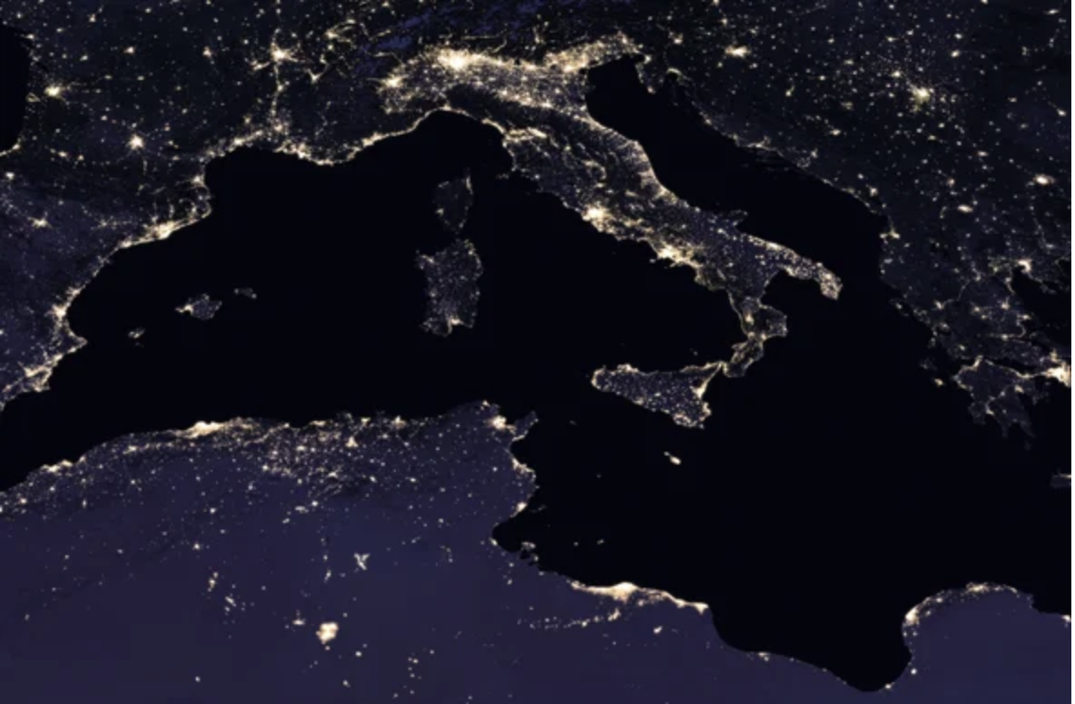
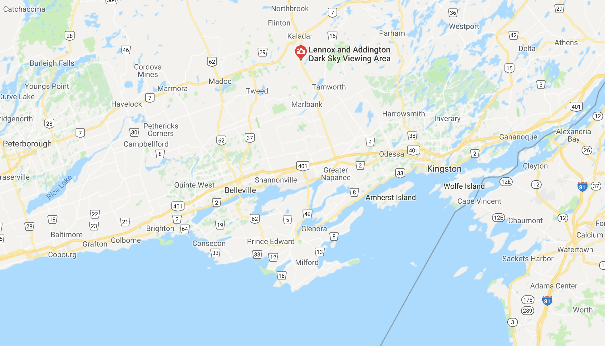
 Lennox & Addington County Dark Sky Viewing Area
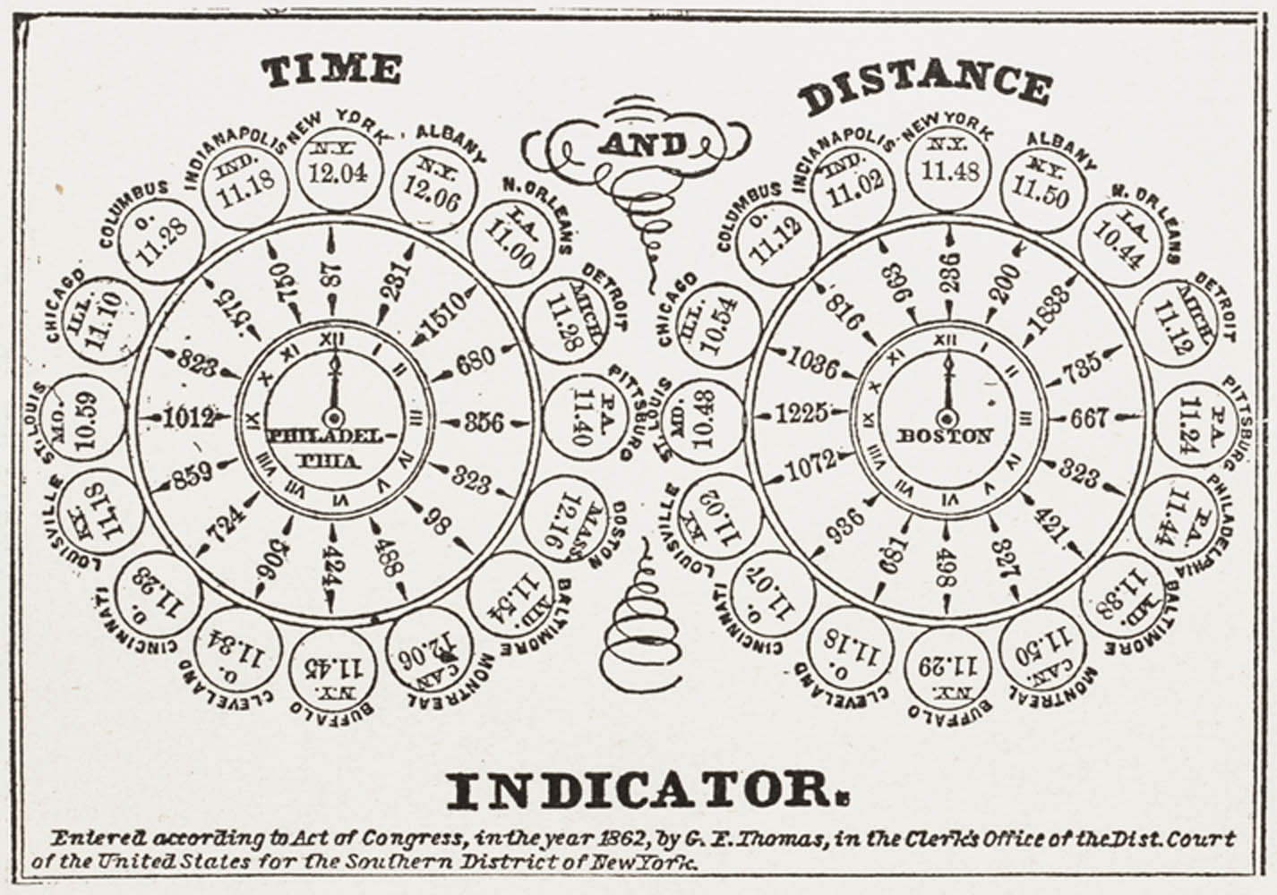
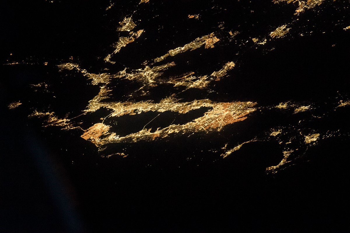 Randy Bresnick/@AstroKomrade
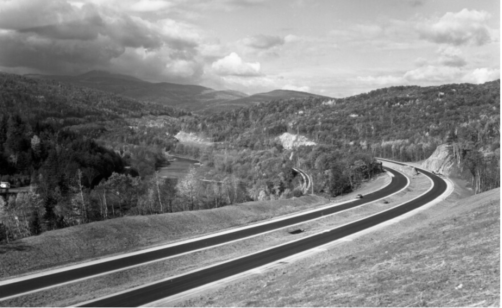

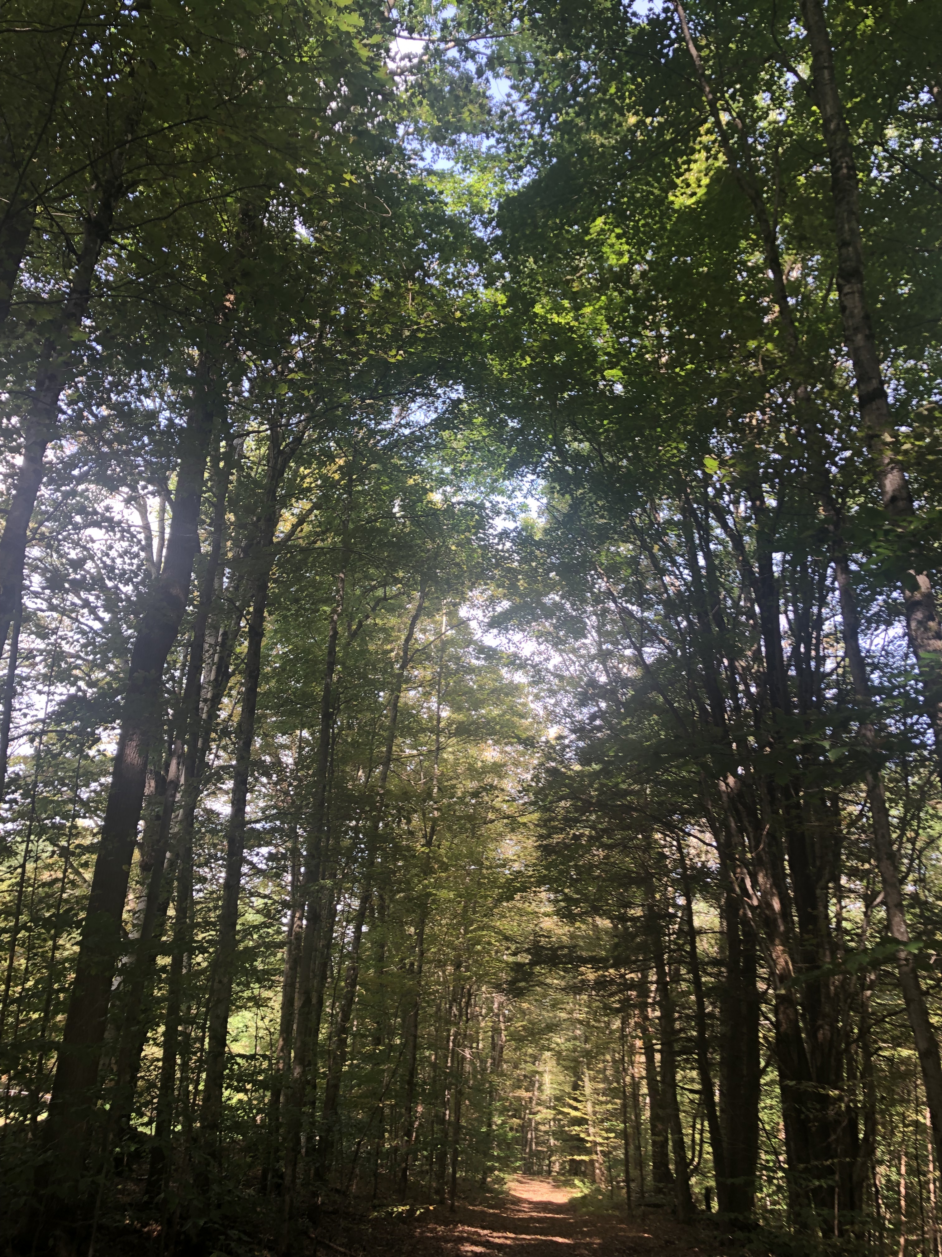


![The back of this 1964 photograph reads, "Unvailing [sic] of new gas signs on I-89." An exhibit at the Vermont History Museum features historic photos from before, during and after the construction of the state's interstate highway.](https://www.vpr.org/sites/vpr/files/styles/medium/public/201311/interstate-signs-2.jpg)
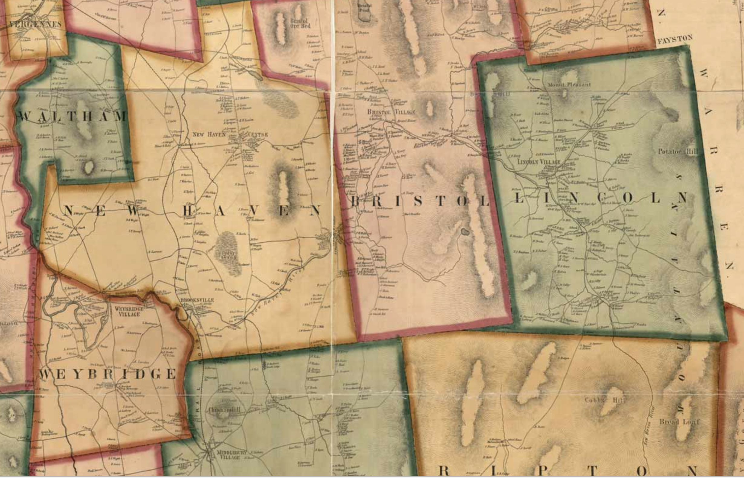
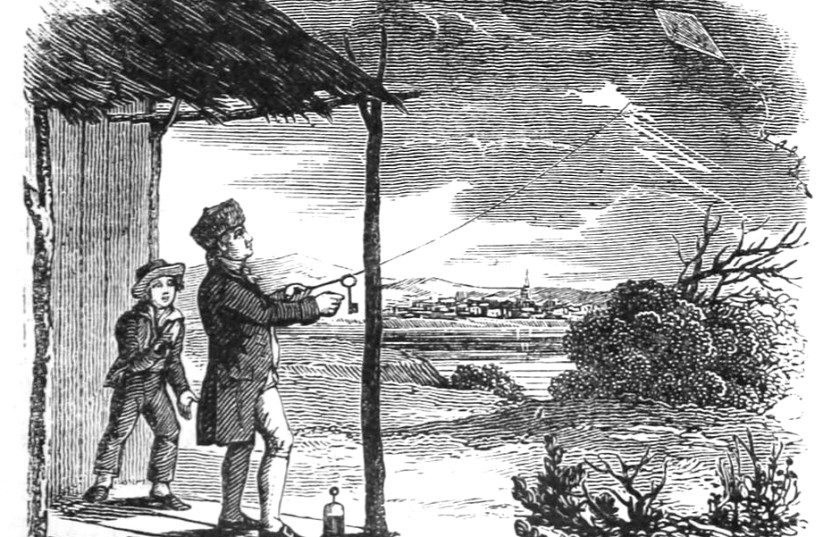

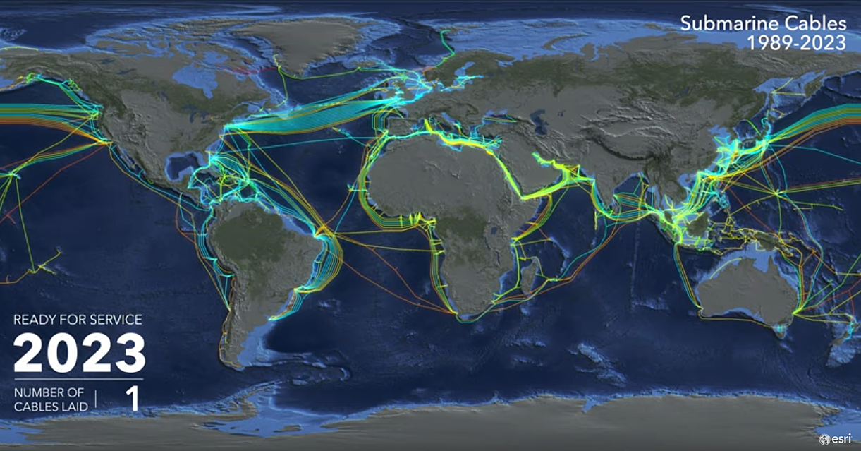


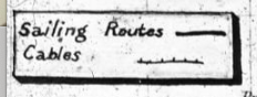
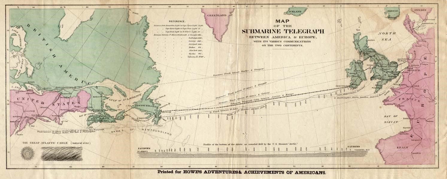
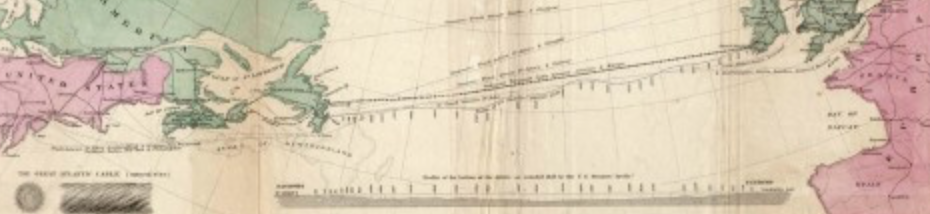
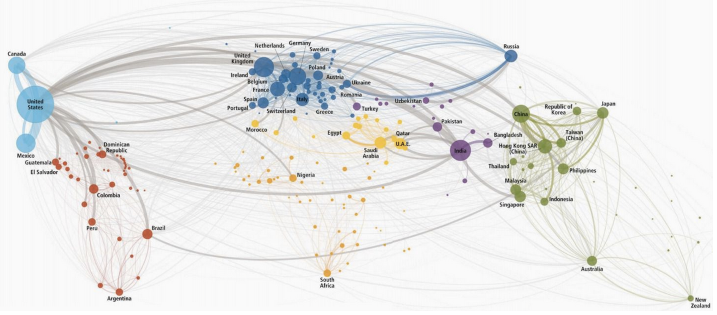
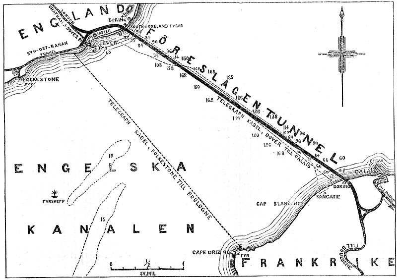
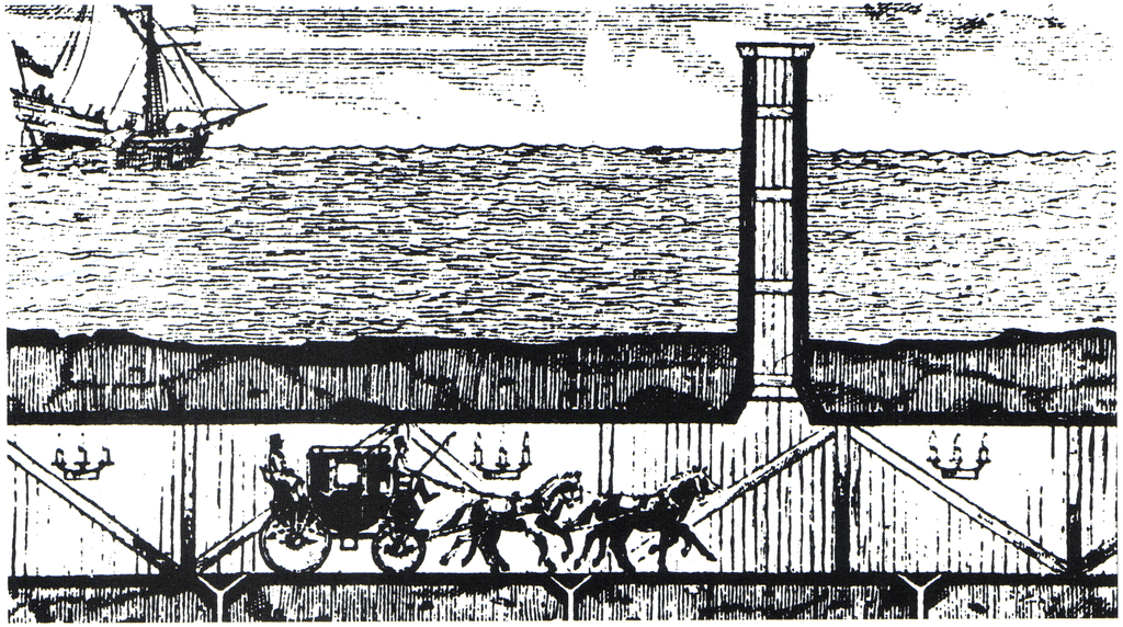
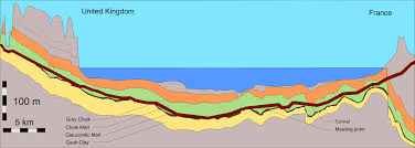
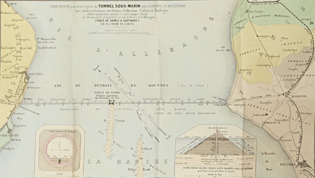
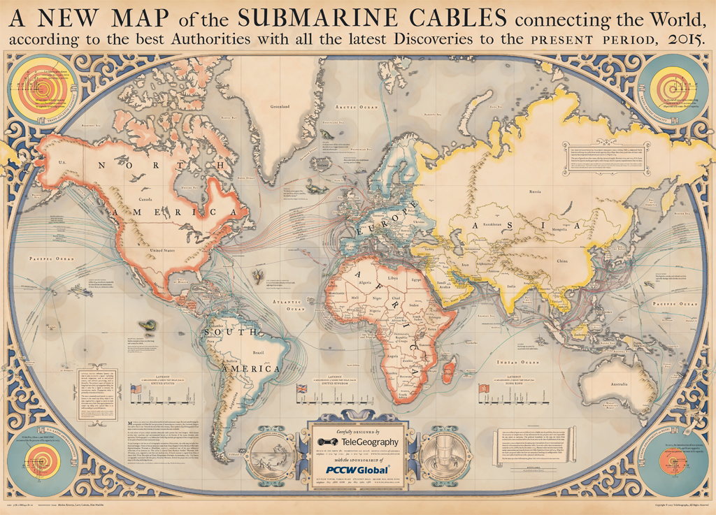
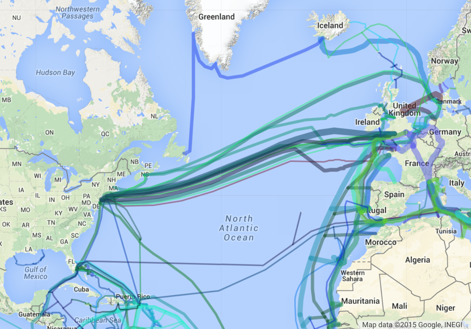

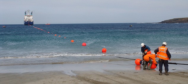
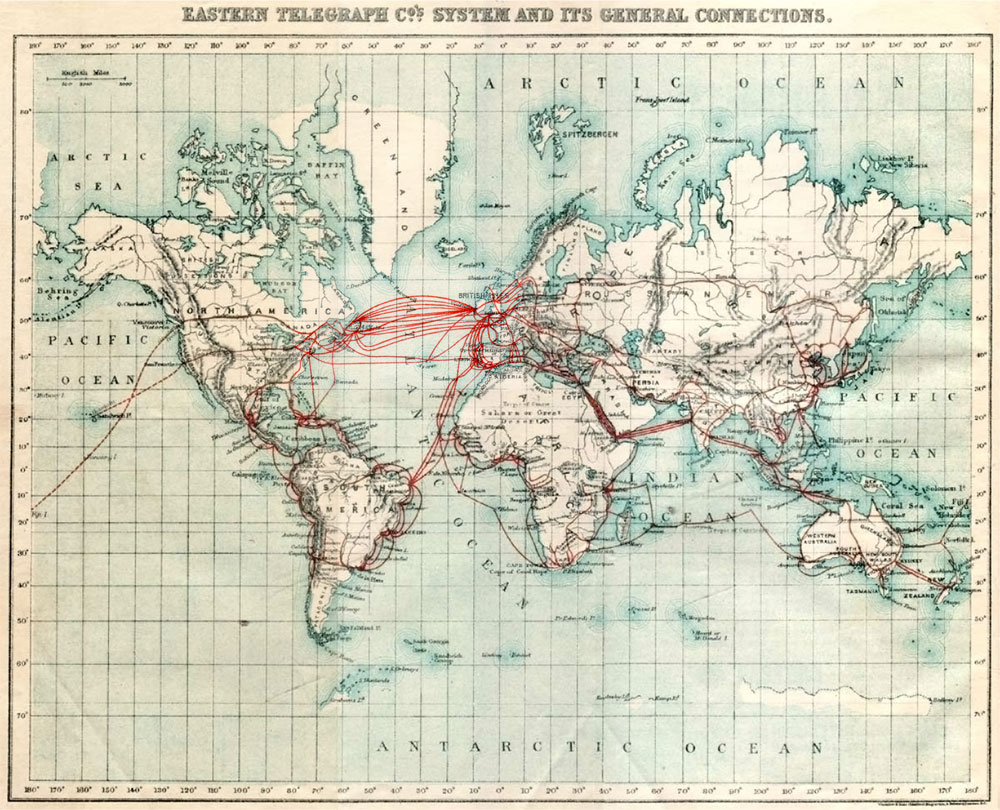
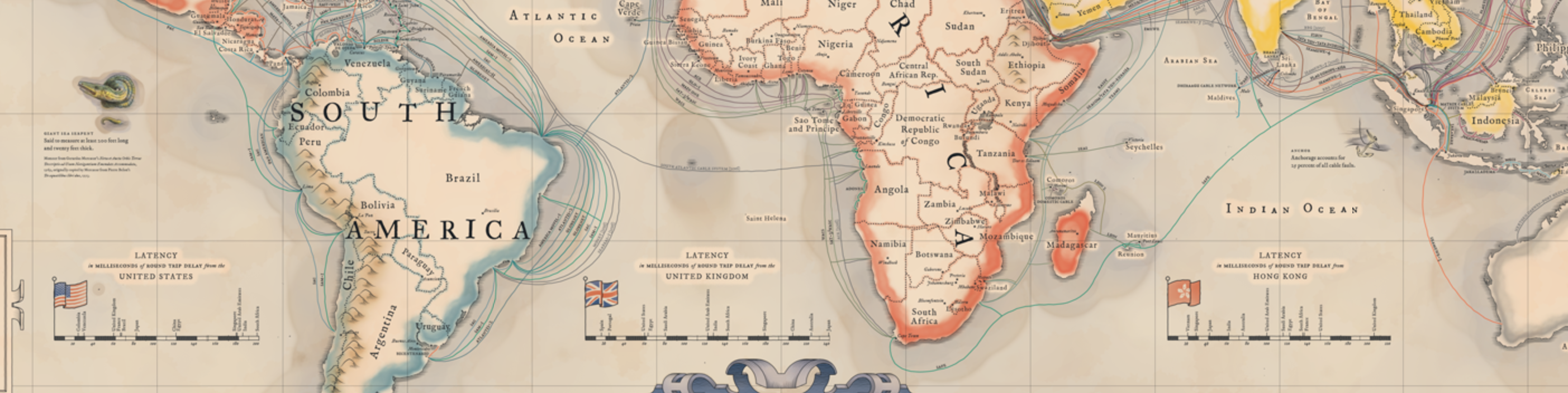
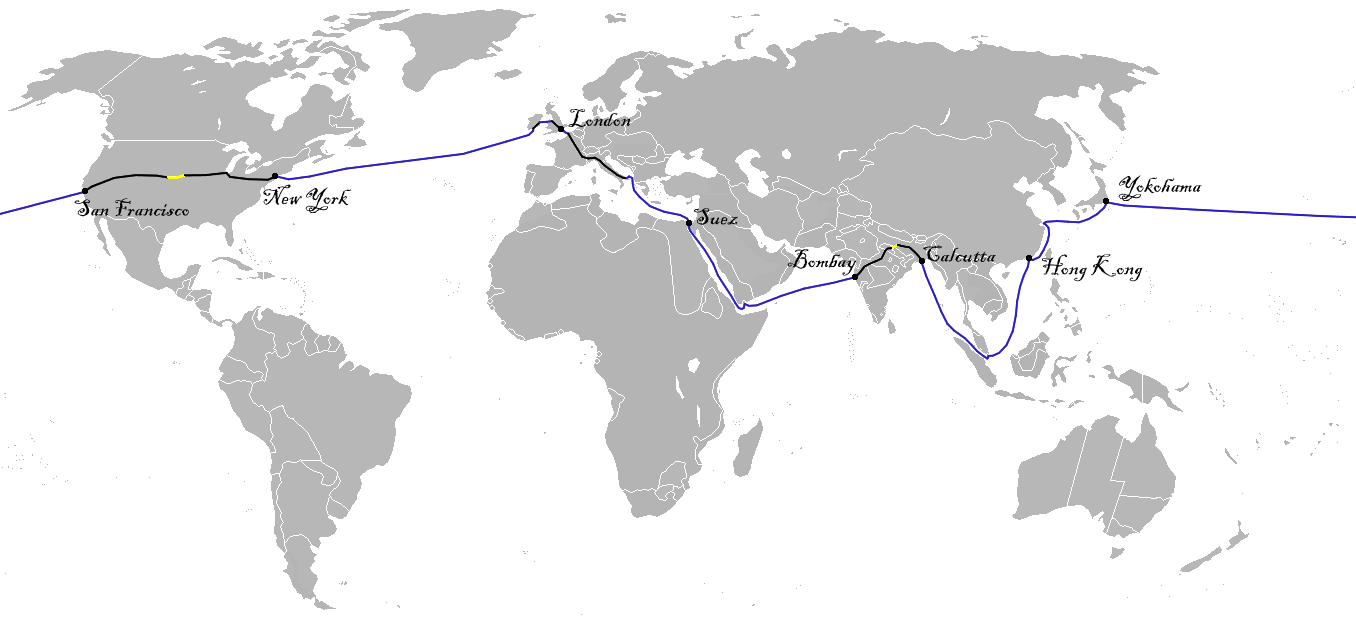
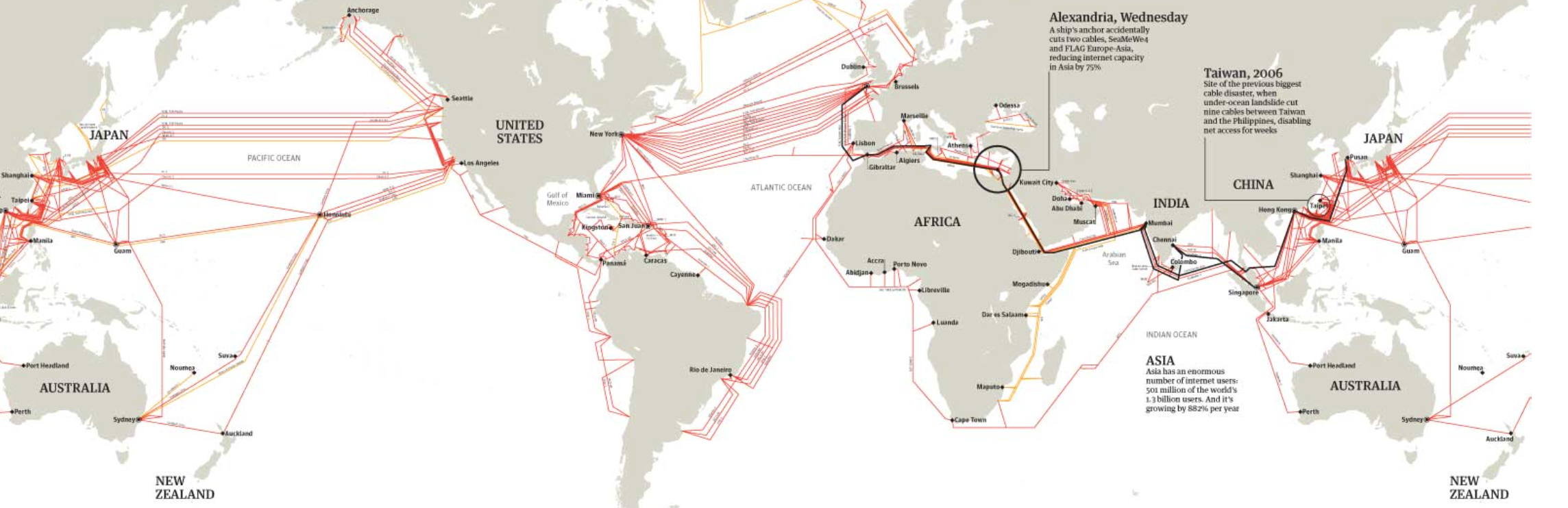
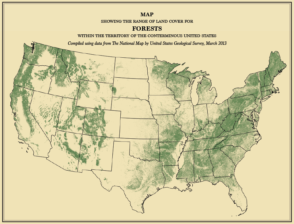


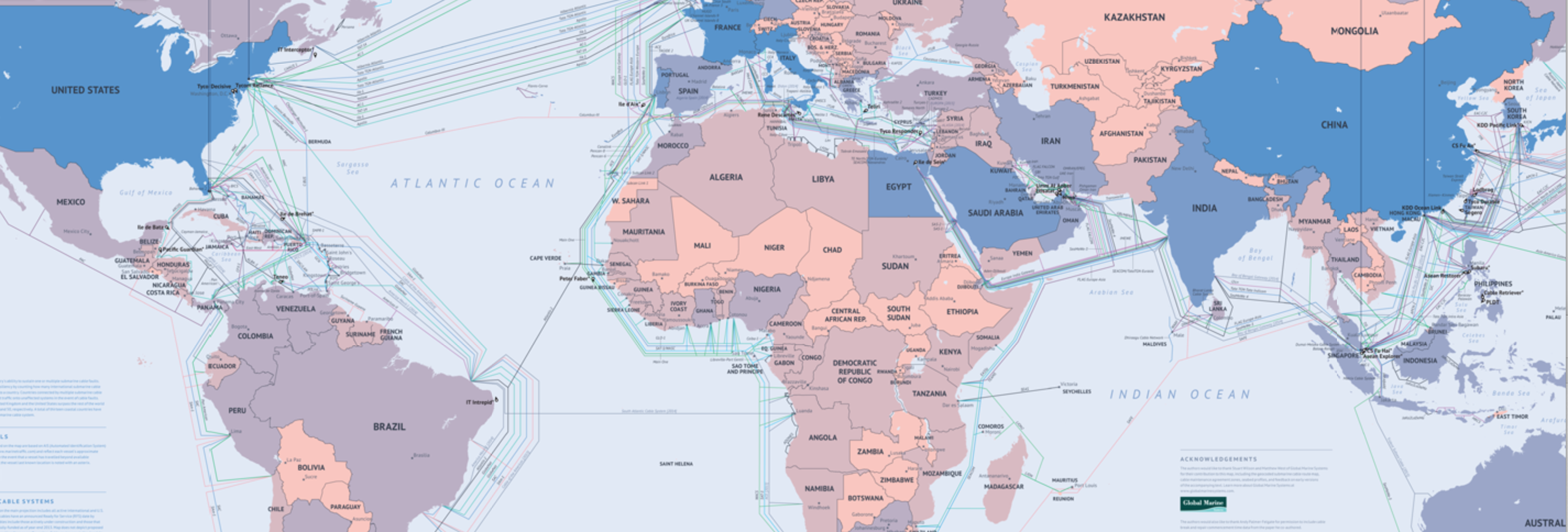
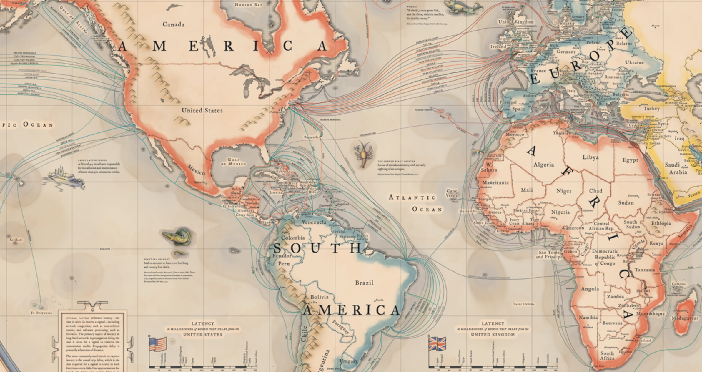
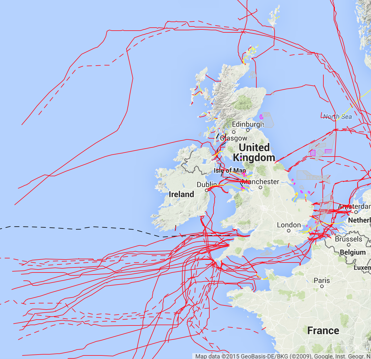
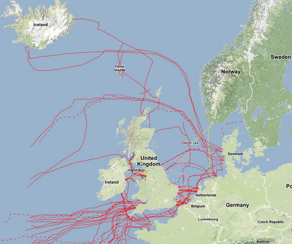

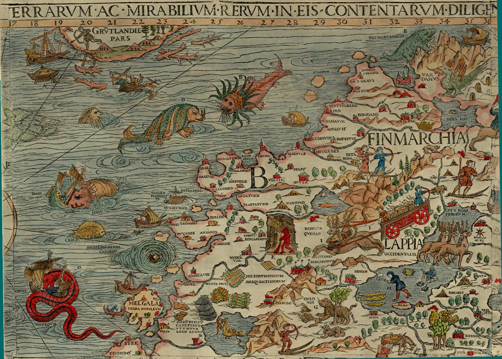


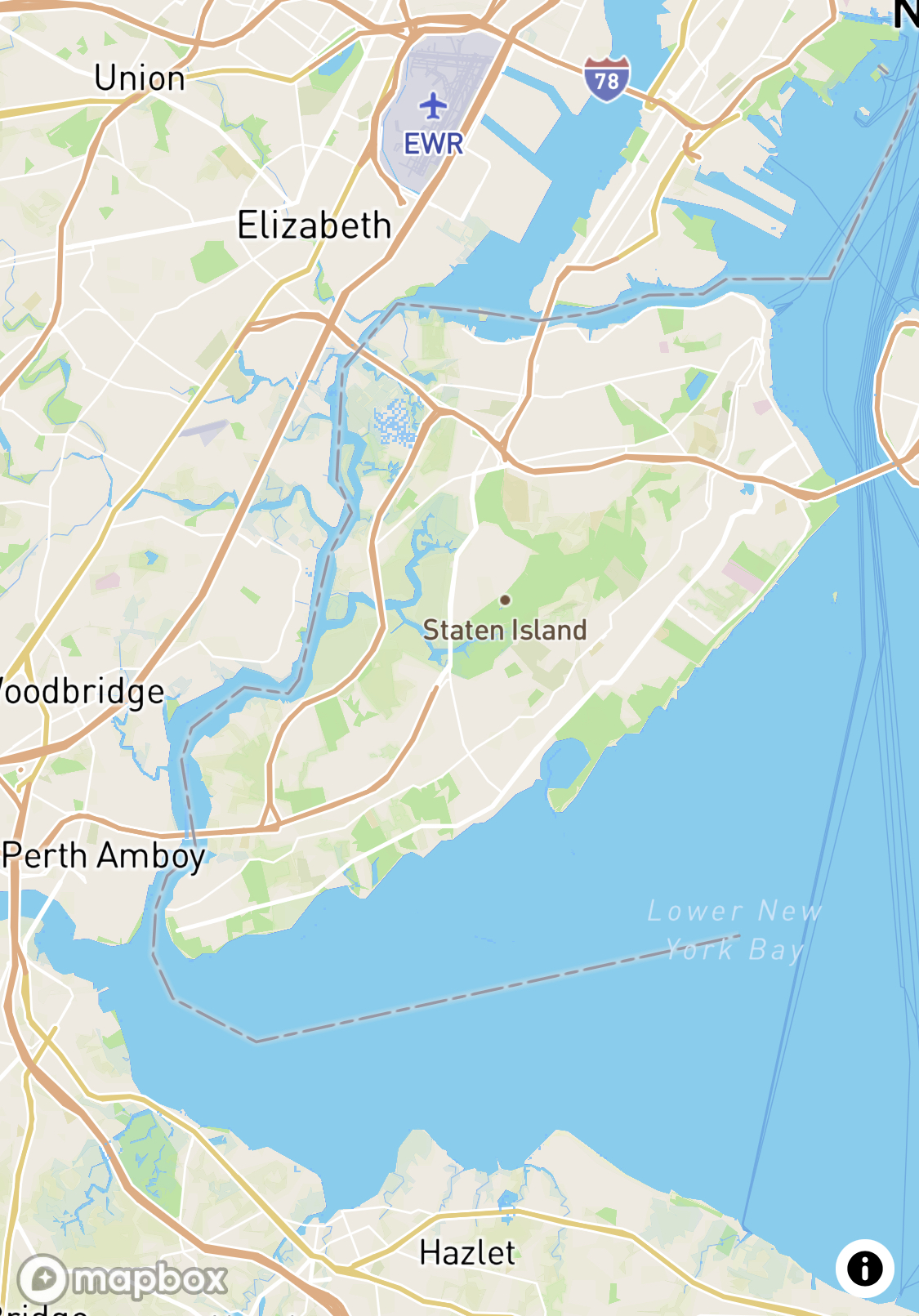
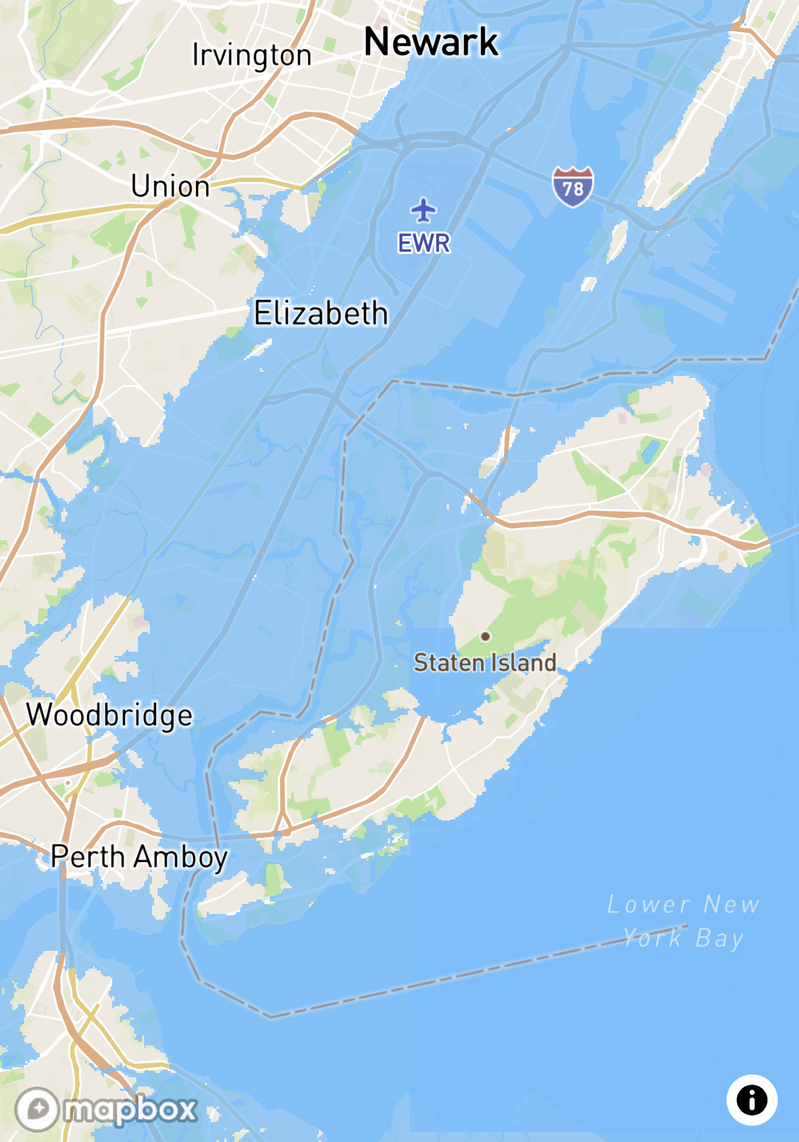
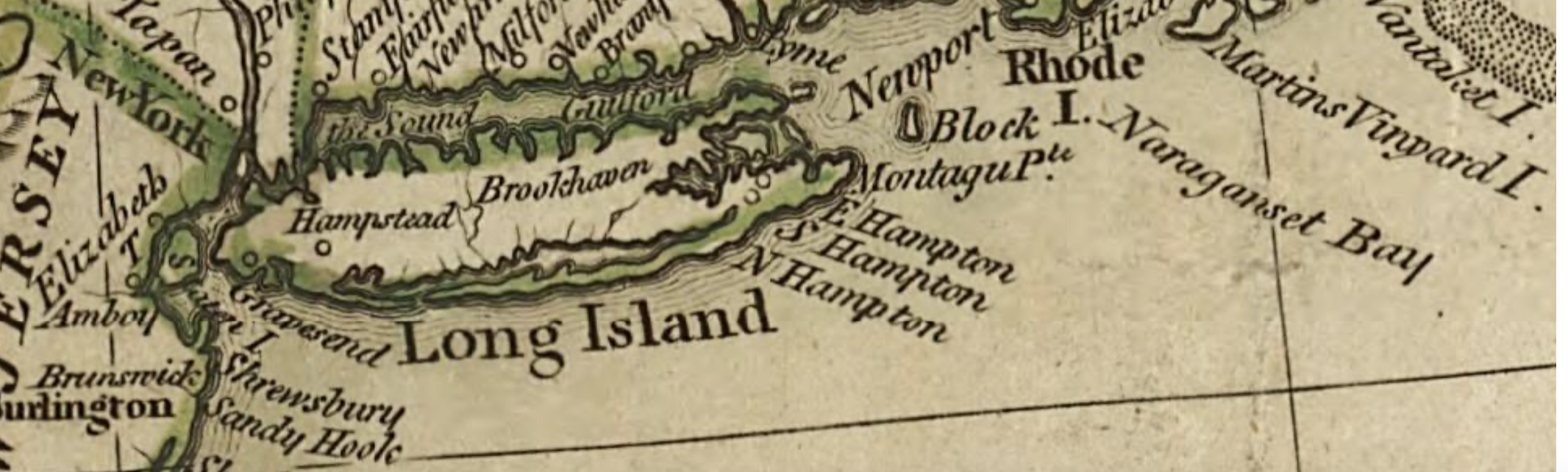
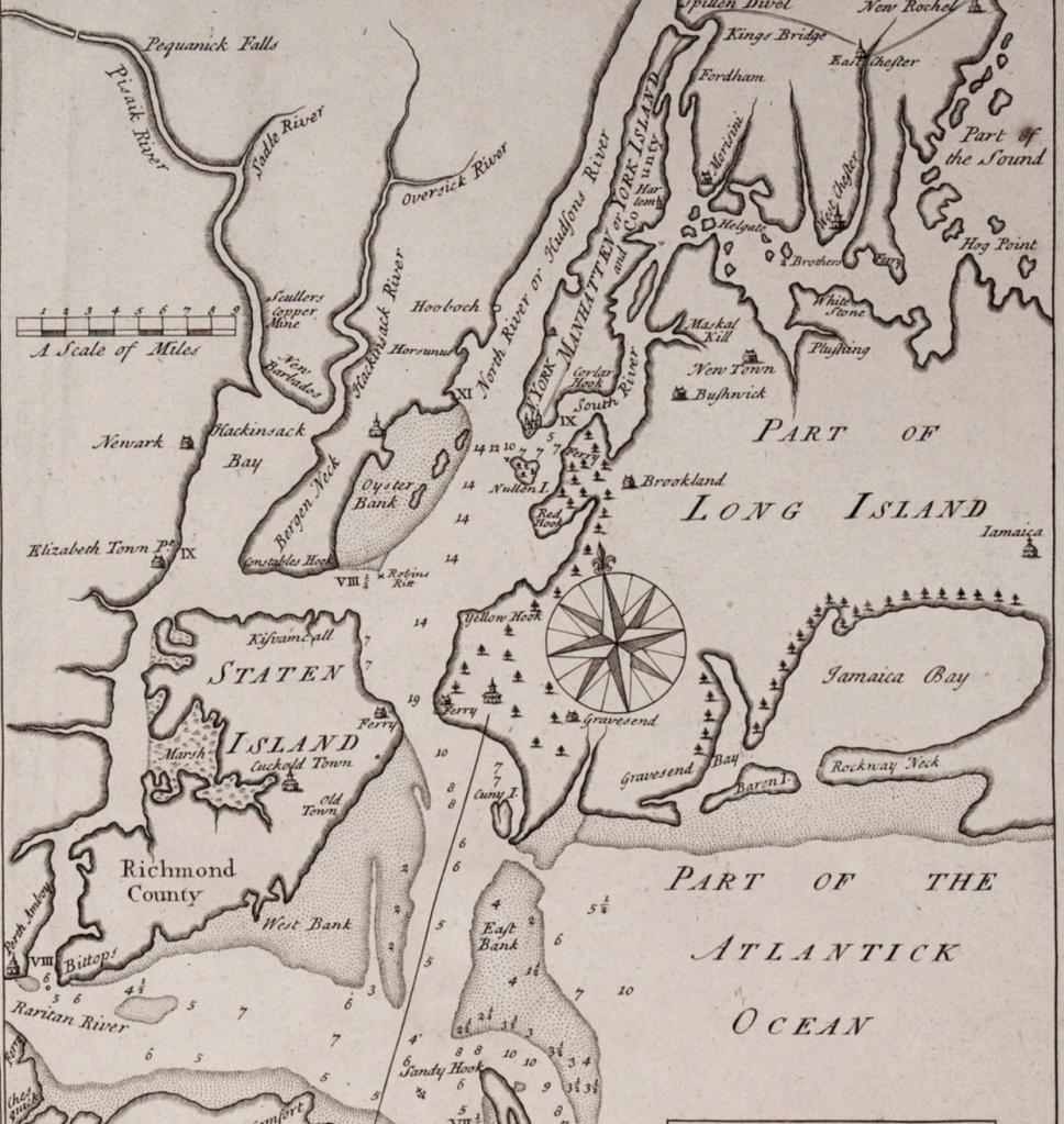
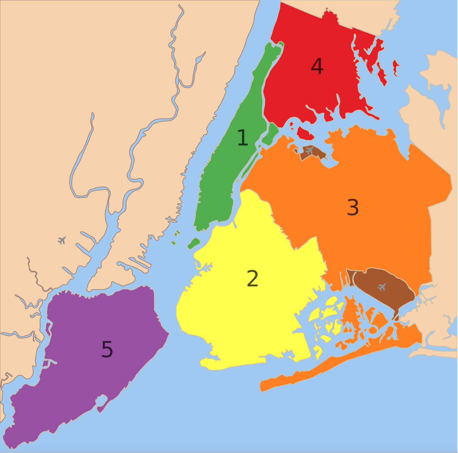
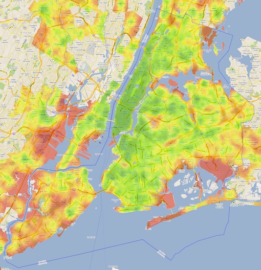
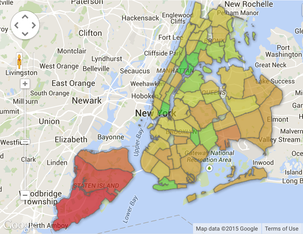
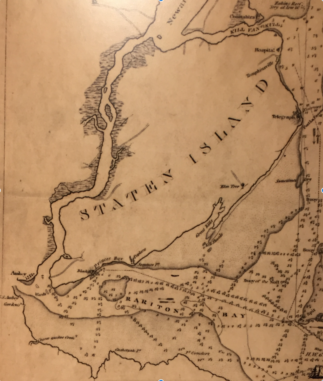
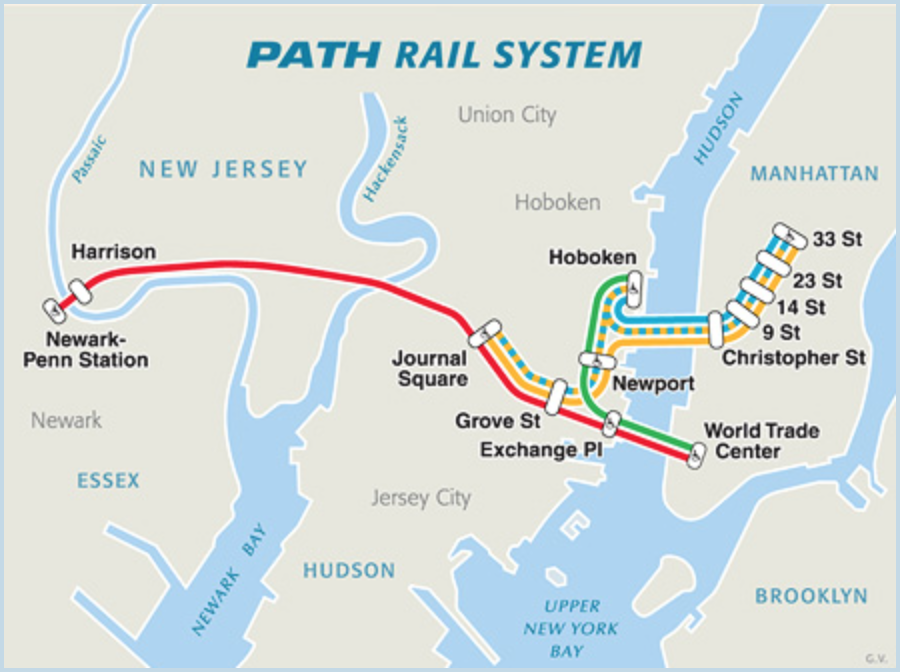
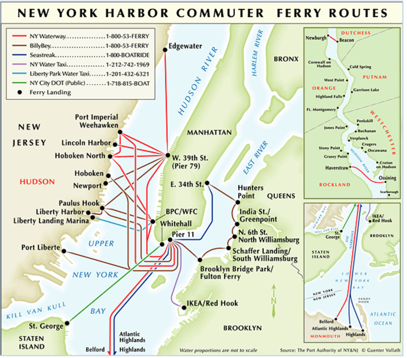
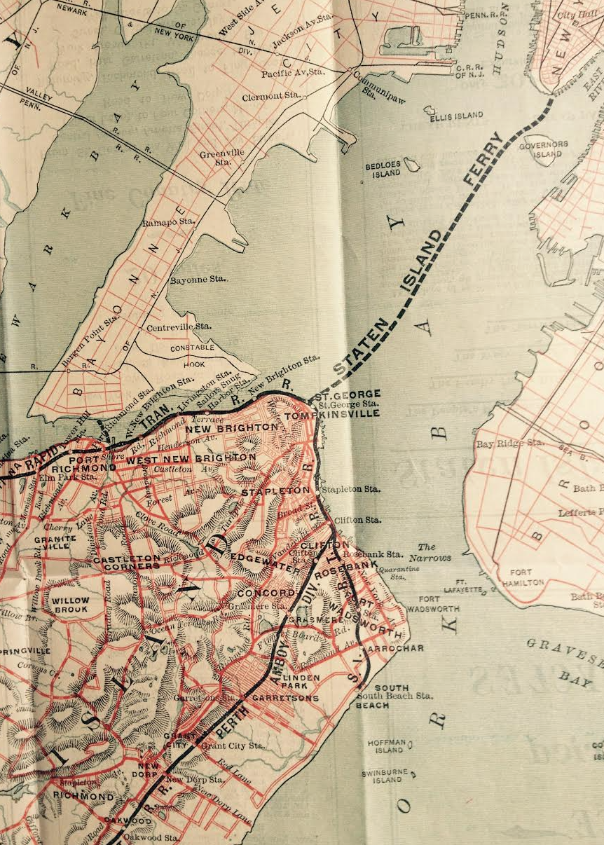
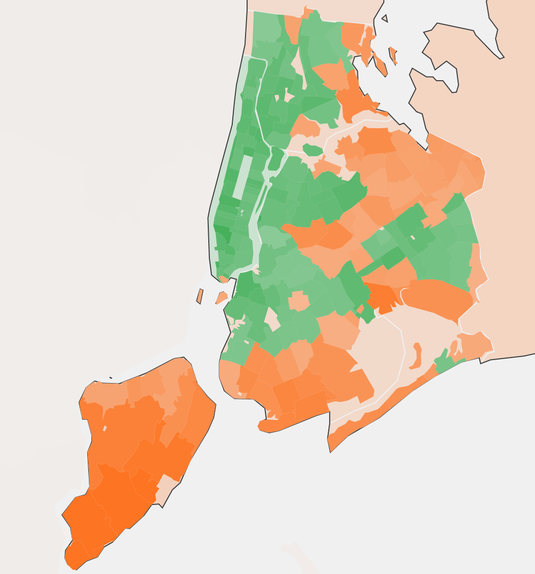
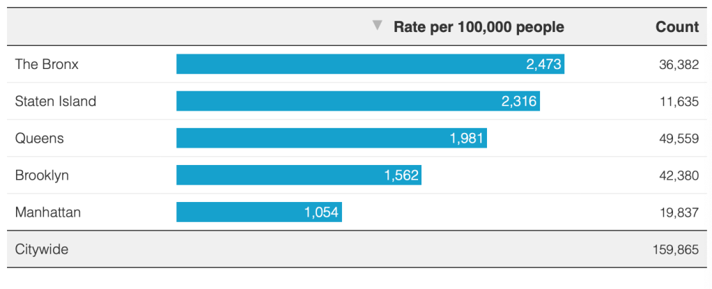
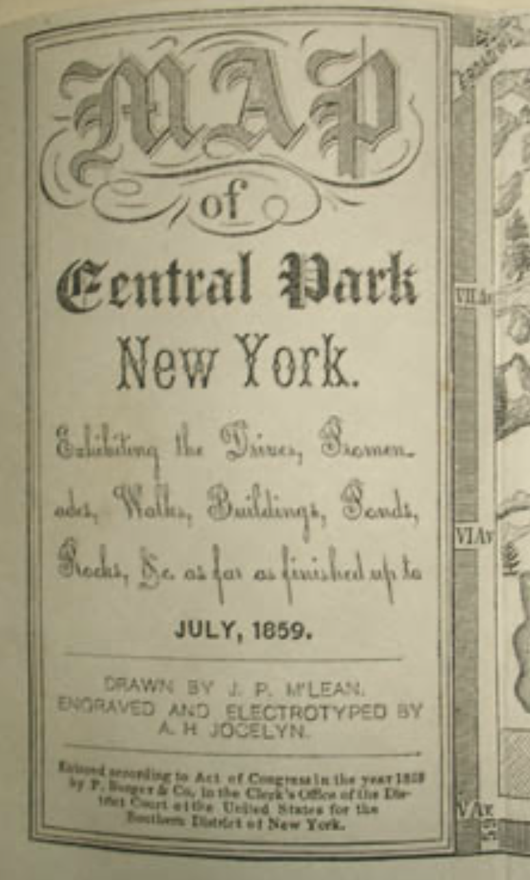
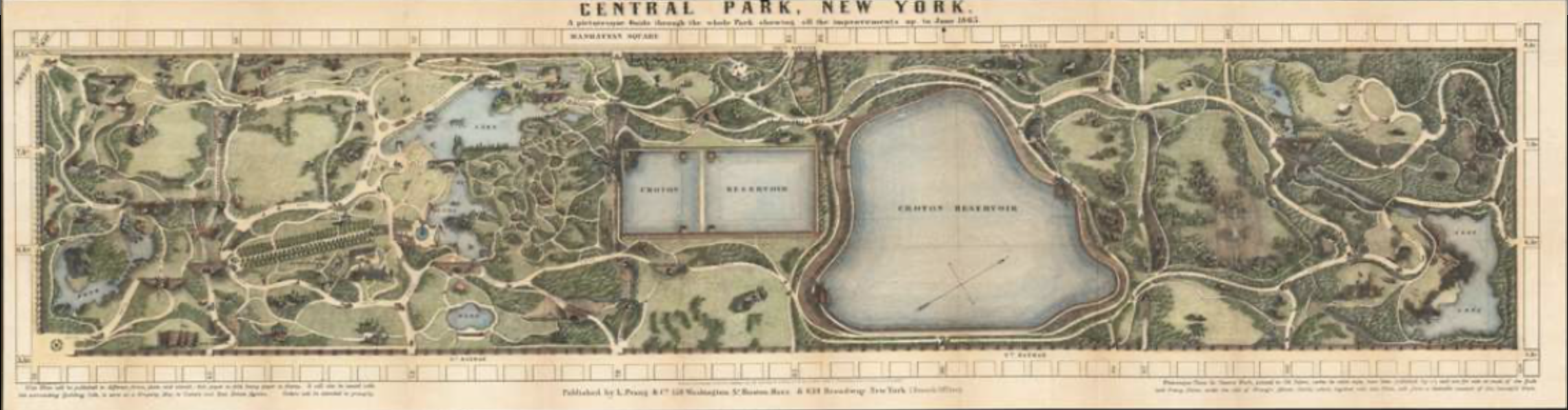
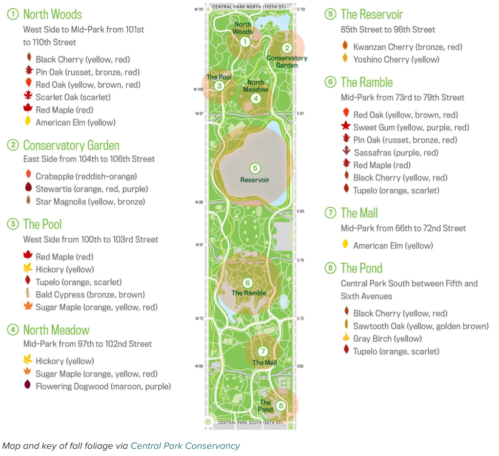
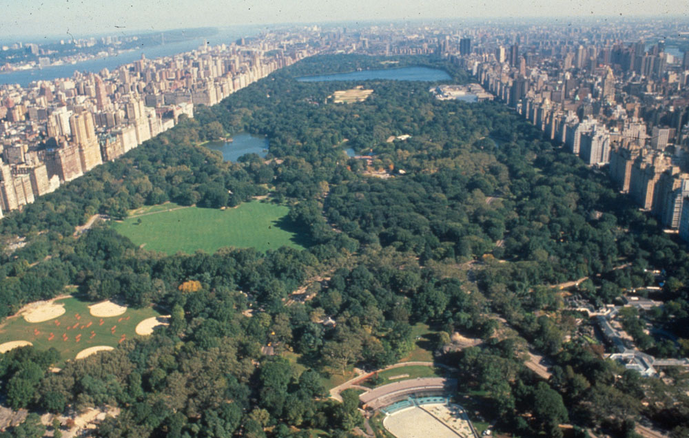

