Hostile Homelands: A. B. Yehoshua Excavates Jerusalem’s Boundary Lines

The Palestinian mutely contemplates the sheer concrete expanse of the Separation Boundary as an exile from his homelands, as if pressed by the newly constructed boundary barrier that he rather stoically observes.  What passes through his head, we can’t say, but this blurred figure, captured as he rather eerily recalls Rodin’s Thinker, seems to contemplate the new future of a redrawn boundary to which he has an existential relation. The erection of poured concrete walls have created an apparently permanent border boundary across what he regarded as a homeland, and would contest. But the existential present of this moment conceals the depth with which such boundary lines were long historically contested and redrawn on maps, in a contest of wills that transcends the individual or present tense.   For the man outside the Separation Boundary contemplates a complicated map of shifting territories, difficult to bound, whose boundaries have been painfully renegotiated in the past as they are again rewritten in the present. And as we debate “border security” in the United States, contemplating an artifact that was imported in large part from Israel, we would be well to consider its prehistory, and the criminalization of the crossing of borders in the past. Does A.B. Yehoshua’s imagined archeology help us to do so?

Difficultis of discerning this face of the figure contemplating this Separation Boundary doesn’t conceal that his removal from the city of which he is resident, and the traumatic division among two halves of the city that he once knew as his home.  If the dream of Zionism parallels the time of the commission and production of monumental bronze castings of The Thinker, commissioned in 1880 from the sculptor who began to produce multiple versions from 1904, around the foundation of the political movement of Zionism launched in 1904, to establish the protection and international recognition of an Israeli stage, the fiction of deep affective commitment to the place and boundaries of Israel in the historically defined Holy Land is the subject of seductive palimpsestic unpeeling of the past of one family in A.B. Yehoshua’s Mr. Mani, a historical novel retrospectively stretched across five generations who seek their orientation to a Holy Land and to Jerusalem in ways that they cannot fully ever grasp–but which the reader begins to as he reads the novel’s five parts, as the boundaries of the state of Israel are peeled apart over time in what seems a modern pentateuch of the state, and a new genealogy of the Holy Land.

The boundary line that has been drawn over an area once easily and regularly crossed by foot suggests the deep stakes at claiming a tortured relation to the homeland by the Israeli state, and the threat that the rebuilding of this boundary creates not only in his psyche, but that haunts the psyche of the Israeli state.  The deep memories of a tie to place that the boundary barrier seems to defend cut off residents from their home, even as they intend to create claims. The contrast between the existential remove of watching the concrete separation barrier recently constructed in the city and the historical attachment to the land of Jerusalem prompts questions of archeology of boundaries, barriers, and attachments to place.  The tension between the most recent barrier and the deep historical ties to place seem to condense the repeated historical redrawing of boundaries in the city and the nation, and  psychological problems of drawing or respecting boundaries between peoples and individuals, and the fragile nature of place across shifting boundaries. If rooted in questions of migrations from Europe, across the Mediterranean, and in Israel, which gains concreteness only in the difficulty to map the psychic relation of the person within this place.

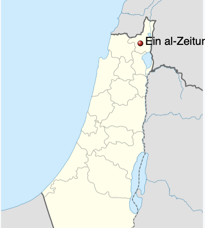
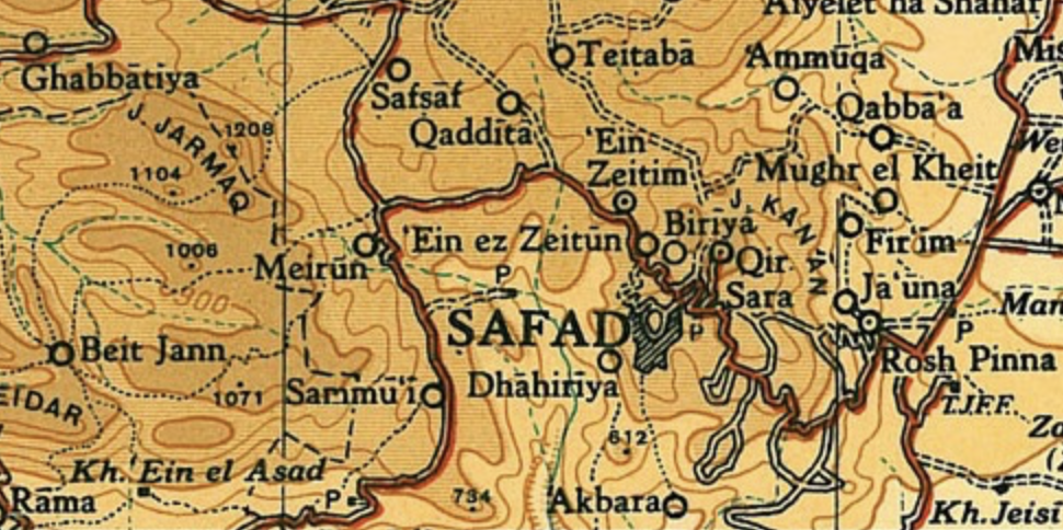
Elias Khoury begins Gates of the Sun by describing the specific romance of the map in similarly inter-generational terms, and in truly global terms as ruminating over over the spinning of a globe in a camp outside Beirut, Abu Salem remembers a past toponymy in mesmerizing manner, shifting from Biblical to Palestinian register that shifts to from rhapsody to melancholy and from a real to an imagined map–“”That’s Acre. Here’s Tyre. The plain runs to heart, and these are the villages of the Acre district. her’s Ain al-Zaitoun, and Deir al-Adsad, and al-Birwa, and there’s al-Ghabsiyyeh, and al-Kabri, and her’s Tarshiha, and there’s Bab al-Shams. . . . . Ain al-Zaitoun is the most beautiful village, but they destroyed in in ’48,'” describing an Arabic Palestinian village that existed from the sixteenth century which was depopulated and left the map, as it entered the new boundaries of the modern Israeli state–within whose boundaries it disappeared, receding from maps into personal memory.

The historical challenges of occupying Jerusalem, and indeed preserving a deeply personal and spiritual tie to land, seems tied to border crossings–and indeed creating boundaries–across the city’s ancient geography that the man stoically overlooks.

Coex https:::framasphere.org:tags:employee

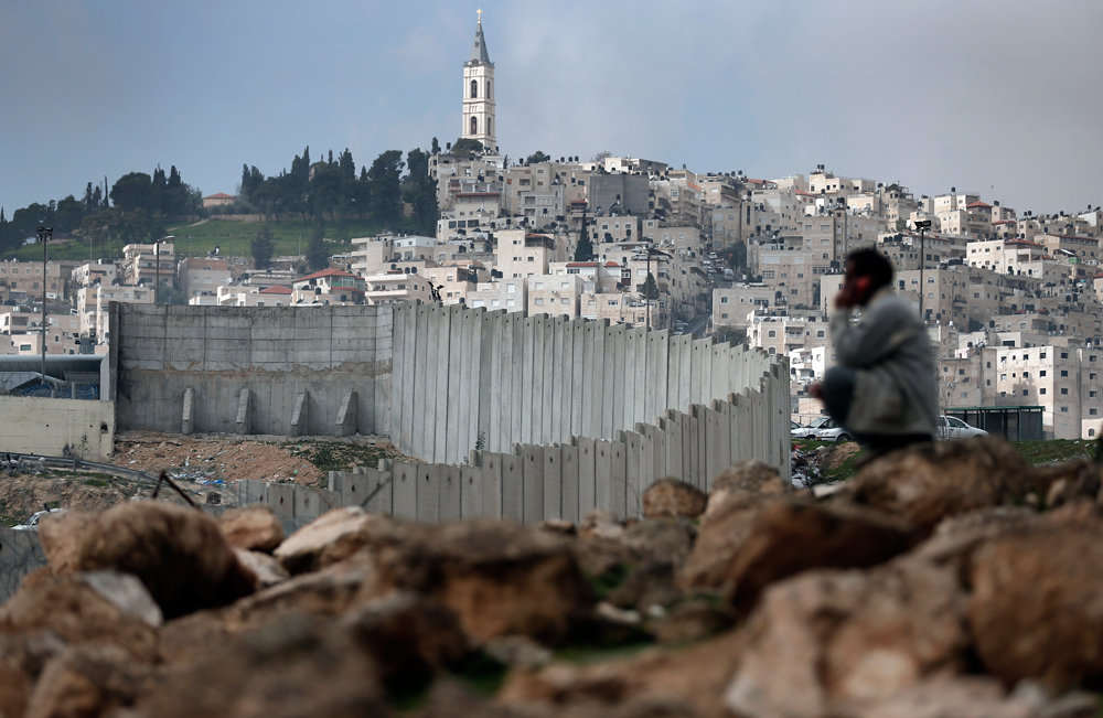
We are perhaps all too ready to project his traumatic relation to the the contested boundary lines of contemporary Jerusalem, where concrete walls cuts Palestinians from the very regions of a city they long inhabited as it seeks to redraw its map, as if to further traumatize its residents.  While the figure of the Palestinian echoes the notion of a Rodin’s Thinker, contemplating his place in the world, he has a far more clearly located place than the famously mobile piece of sculpture, whose reproduction in casts and in marble transited around the world, moved on a pediment to any space, evoking an idealized act of thought in whatever context it stood, begging the question of its own subjectivity in relation to space:

Legion of Honor, San Francisco, CA

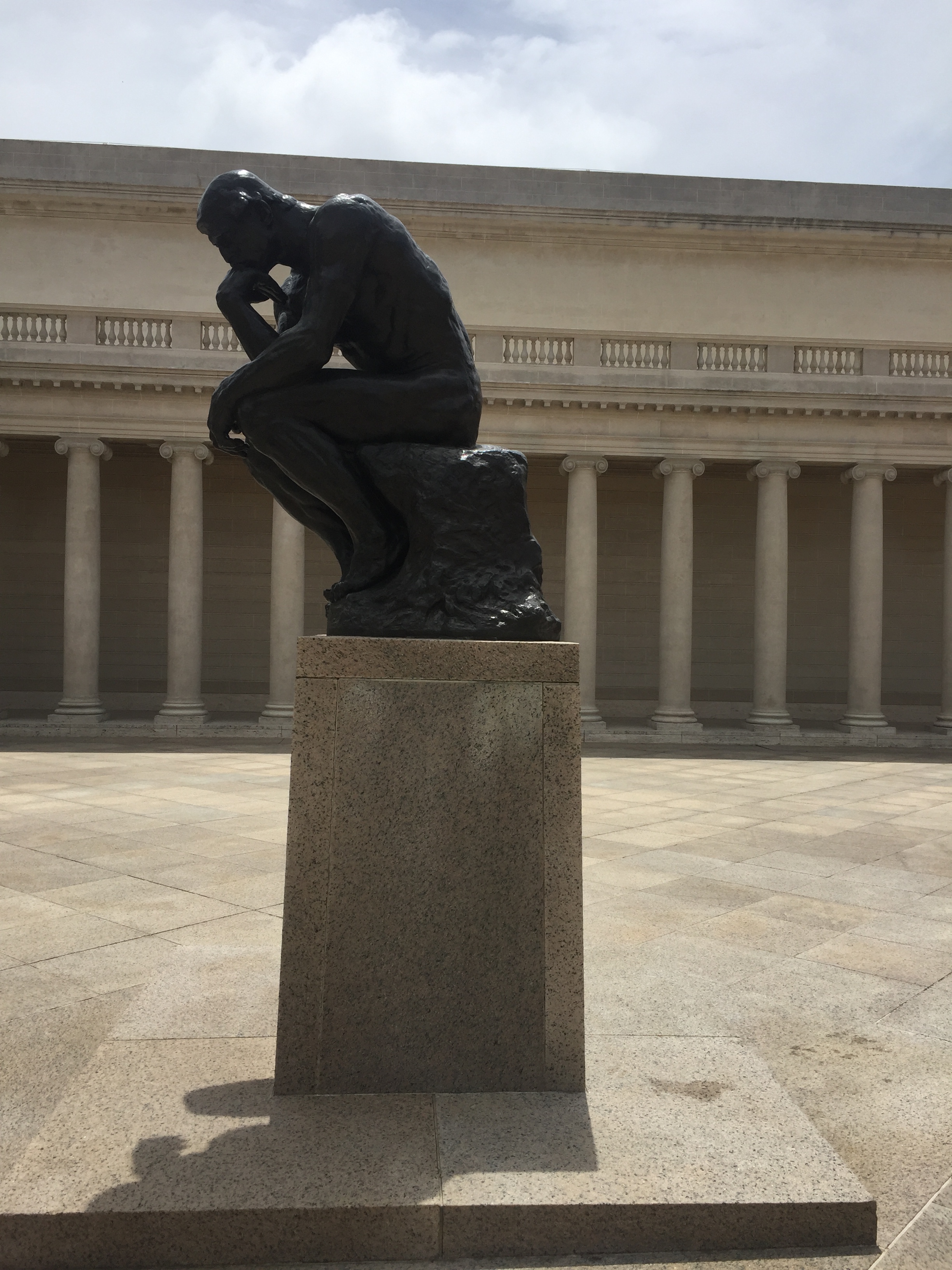
As a student who had studied in Paris–and, one imagines, understood the possibility of Hebrew as a literary language that would embrace multiple identities and subjectivities, as French did in the monde francophone–the image of a Rodin statue is, while a bit jarring to place as an explanatory motif to enter the Holy City and boundary-drawing of the Israeli state, an apt choice to place Yehoshua’s very public if not political literature in relation to the boundaries that he witnessed drawn up around the Israeli state, and treated his own work as a testimony to. It is striking that, of course, unlike the subjectivity of an Arab or Israeli, multiple casts of Rodin’s statue were famously mobile, able to circulate globally, independent of site, as icons of man’s intellectual superiority over the world and his surroundings. But the man sit with a site-specific sense o reflection, and effectively caught in the act of being displaced from his surroundings: a city which has long been praised because of its integrity in the religious imagination, and translated to a nation a term that was long reserved for applying to a people, has been beset by divisions that the boundary wall has mapped in Jerusalem is both palpable and insurmountable reminder. The statue reveals a pragmatics of division that is oddly and paradoxically described as intended to preserve the integrity of the city, by defining its place and security in the public imagination as if to recuperate and preserve a sense of the imagined topography of unity of the Mandate in 1946–before the foundation of kibbutzim, before the Irgun’s armed resistance to British military authorities, and before the foundation of the state Israel, if with clear boundaries of sovereignty.  

Did the story of the settlement of Jerusalem as a succession of subjectivity offer a truly transcendent relation to place, before which maps receded as purely provisional conventions to orient one to space or place? The novel provides a place, perhaps, if a bit by happenstance, as expressive of the cosmopolitan remove and liberal principles by which A.B. Yehoshua seeks to map the place of the subjective figure in the fractured Holy Land, and indeed the recuperation of Enlightenment principles by which to do so for a literature that he sought to provide the country, very much as a pragmatic resource akin to plumbing, running water, or electricity and gas, as much as a refined culture. The embodied culture of space may have led Yehoshua, whose father arrived from Salonika to the Palestinian Mandate, and whose mother arrived with her father from Morocco, when few Jews lived in the area that became bounded by the future state of Israel, to angrily reject the existence of the diaspora as a future for Jews and even as a meaningful or authentic mode of being for modern Jews, and especially among his readers: if Mr Mani seeks to orient its readers to the complex drawing and redrawing of boundaries in the Middle East around Israel, in order to transcend them, and takes the figure of a succession of subjectivities to provide a unity by which to place oneself in the continuity of the Israeli state, despite its modern creation, Yehoshua railed angrily in increasingly bitter terms about the diaspora or galut as “masturbation” rather than true being, in later years, as if in relation to his own sense of impotence at the sheer size of the diaspora–a reflection of the prospect of his own sexual impotence?–compared to confronting a multi-ethnic sense of territoriality in Jerusalem, and in the Holy Land, he had first encountered as a child.

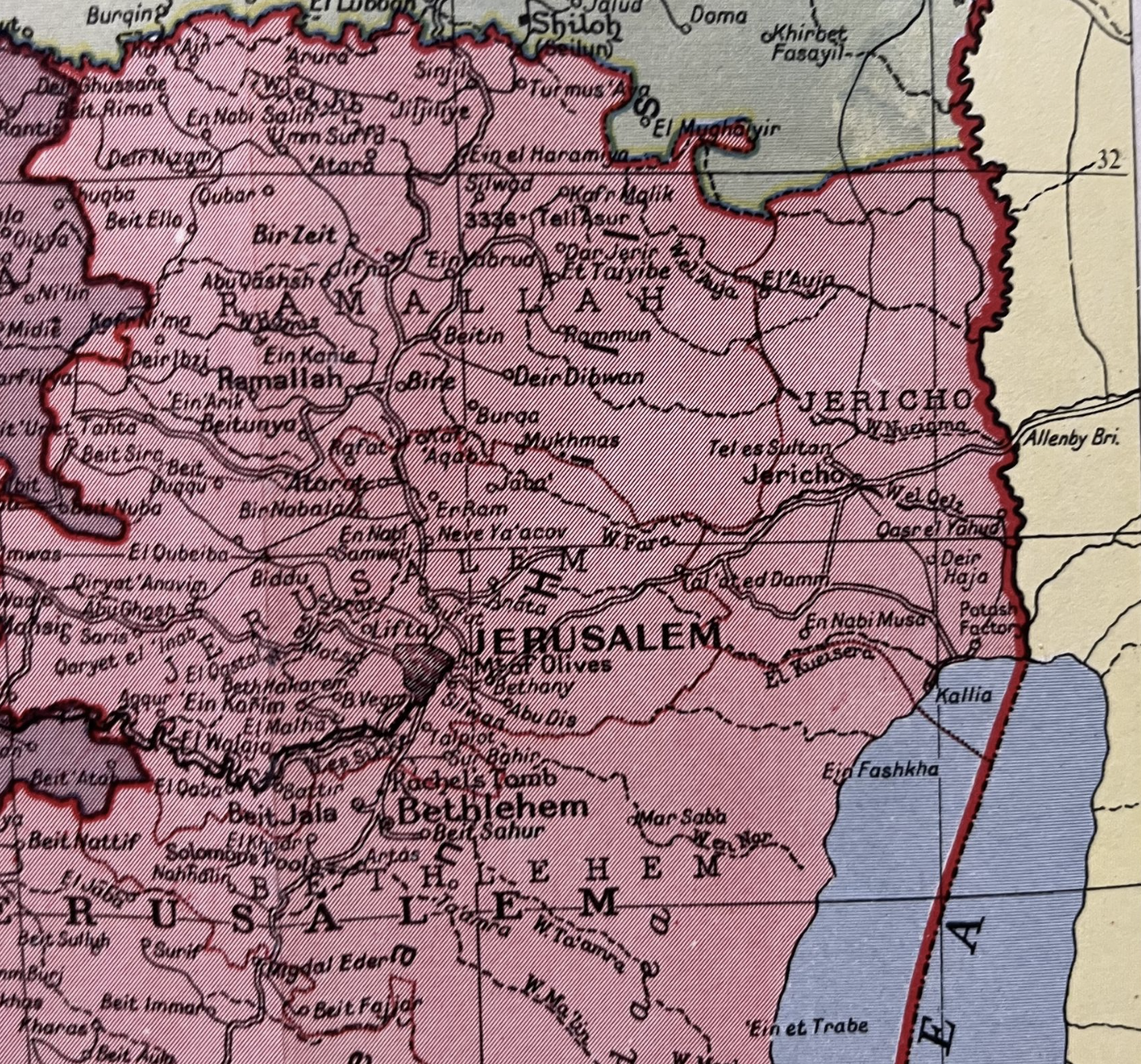
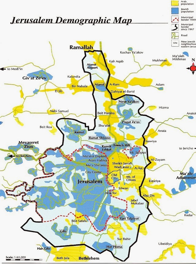
The sectorizing of the city by such boundaries were akin to a rejection of history, or of the Zionist vision of crossing borders–a vision, to be sure, later corrupted in the shift of Zionism to Israel’s borders’ fierce defense. The sense of imposing borders on history, however, and on place, led Yehoshua to create one of the fiercest stories of the repeated crossing of borders over time, of location despite borders, a book written in a sort of locative voice, transcending early proposals dividing the city among Arabs and Jews drafted the very year of Yehoshua’s birth in the Palestinian Mandate, and a vision of segregation that the work and vision of his father to create a commonly understood legal code would span. The turn to writing and to stories to suggest the intertwined nature of Jews beside Arabs, not segregated apart, provided a means to narrate the demographic mixture of Jerusalem at the time–the city was populated by about 92,000 Jews; 32,000 Arabs; 27,000 that precipitated the division of the city into East and West regions as the prospect of a Jewish Mayor of Jerusalem was flatly rejected

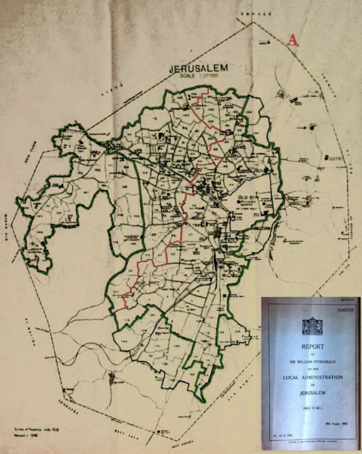
Proposed Partition of Jerusalem’s Local Administration into Jewish and Palestinian Sectors, “A Proposal for Dividing Jerusalem between Jews and Arabs (Survey of Palestine,” Jaffa Aug., 1936)

The crossing of boundaries and persistent problem of crossing boundaries to preserve a coherent vision of Zionism becomes the question or logic for the generations of Mani in a question of what Rivka Galchen called “serial subjectivity” that cannot be understood but in relation to the impetus of crossing boundaries of the map, itself drawn in the year of Yehoshua’s birth. The fictive figure of a “Mani” at the center of this fictitious archeology of a heterodox in Jerusalem parallels the reconstruction of the historical figure of “Mani,” a prophet who was a member of a large Jewish Christian sect in Babylon with strong Gnostic elements as the future prophet described in the New Testament. Mani’s faith was rooted in the creation of a new gospel, in visions perhaps influenced by the fact that his mother was of Parthian descent, of Armenian origins, and was raised in a community of Jewish Christians, but who preached a heterodox faith that combined Christianity, Hinduism, Buddhism, and Zoroastrianism in a new heterodox complexion: he wrote six works in Syriac, and was eventually crucified after he preached his idiosyncratic heterodox faith to the Indian court of Shapur I in 242, crossing barriers in his life that the six generations of Mani whose fictional archeological record Yehoshua invites the reader to sort out across recent incursions and wars, each replaying the Manichaean conflicts that the historical Mani preached: the genealogy traces conflict across borders in a succession of ages, as if participants replayed the historical Mani gospel of a Manichaean struggle across Middle Eastern borders, asking if the very heterodox combination of cultures can survive. But the combination of boundary crossings that constitutes the basic story or “news” of the novel–fictive news, but news of present relevance–suggests a deep temporality of all boundaries, and indeed offers a means to work toward their transcendence.

The strong sense of an occupation of the city by generations–“All the generations before me/donated me, bit by bit, so that I’d be/erected all at once/here in Jerusalem, like a house of prayer/or charitable institution,” poet Yehuda Amichai evokes the deep tie to a past that physically ties him to Jerusalem’s present and pasts.  The proprietary sense tied to generations of Jews as bound  to the city of Jerusalem by a binding tie to place defies mapping. But the excavation of this actually quite modern sense is excavated in Amichai’s poetry and an inevitable subject of Israeli fiction.  The next poem in Amichai’s 1973 collection, Poems of Jerusalem, turns from the ties to place to the disruptive nature of the border barrier already built in the Old City, on each side of which flags are raised–“To make us think that they’re happy./To make them think that we’re happy.”–but that obscure who is flying a kite over the Old City, on a string held by a child who stands on its other side; if he cannot ever forget his tie to the city, its walls of separation are never able to be forgiven, but “If I forget thee,/let my blood be forgotten,” to describe the tortured relation that he felt in 1973 to the mapping the relation of the city so closely intertwined to his blood-line.

The issue of bonding to place within one’s blood line was more clearly mapped across time when A.B. Yehoshua compiled a fictional dossier on the testimonies across six generations of men residents in Jerusalem in Mr. Mani, a five-part 1992 historical novel that rewrites a Pentateuch of the Israeli state, or at least the Zionist dream of basing a Jewish state in Jerusalem, a city whose layered history Yehoshua knew well from his father, a local historian of the city, and that in a sense captures his own deep ambivalence to Jerusalem as a homeland or occupied city.  By tracing testimonies of the male members of the Mani family who settled in the city and manufactured this imagined tie to place, he allows them to give evidence of their ties to the city across generations we read in chronological reverse, in ways that seem to unpeeled their own deep internalization of their ties to the city of Jerusalem–and the cross-generational desire to create or recreate a physical tie to place. Even if it is only textual, and returns to landmarks in the city, more than to boundaries that we can understand as fixers, the novel traces mental boundaries, offering poignant testimony of the redrawing of Jerusalem on the map. As much as it is a story of the serial succession of subjectivities in Jerusalem, and the Holy Land, the “job” Yehoshua fills for himself of navigating and crossing boundaries–boundaries that were created in his own life, as a man born in the Palestinian Mandate, where his father worked to translate Hebrew to Arabic documents–take the task of forging a new Israeli literature in Hebrew that itself knew no boundaries, but was based in orienting readers to the palimpsestic realities coexisting in the Holy Land. Although this reaction to Yehoshua’s work in the form of a deep dive into the realities of cartographic boundaries was written in the diaspora before Yehoshua’s passing, it is a testament to the persistence of a gravitational pull of place in his work, rendering it as a sort of counter-mapping to the creation of boundaries proclaiming an end of history.

While the novel is removed from historical mapping and remapping of the settlement of the city, it traces a deeply psychic map, preserved in Faulknerian fashion of what might as well be a fictional country but could not be disguised as such. The intensity of personal projects of mapping a relation to place and remapping the desired union of each generation to the city, as if to realize the frustrated desires of their forefathers to map and thereby to create a new relation to place, without attending to its residents, so deep was their desire to protect, redraw, and identify with the place of the ancient city.  The creation of one side of the conversations of the Mani men provides a basis to excavate the deeply unfulfilled emotions needs that they bequeathed their descendants, and the incomplete relation that each transmitted as a failure to bind their own family to the city, and the difficulties that they have mapping their relations onto the presence of the city’s actual inhabitants.  The deep neediness of Mani men reveals the strength of ties of rooting oneself and family in place, and the heightened trauma of such a desire for attachment that has built up over generations, a traumatic tie to place that is visited upon its other residents.

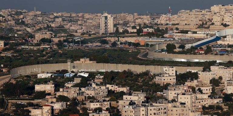
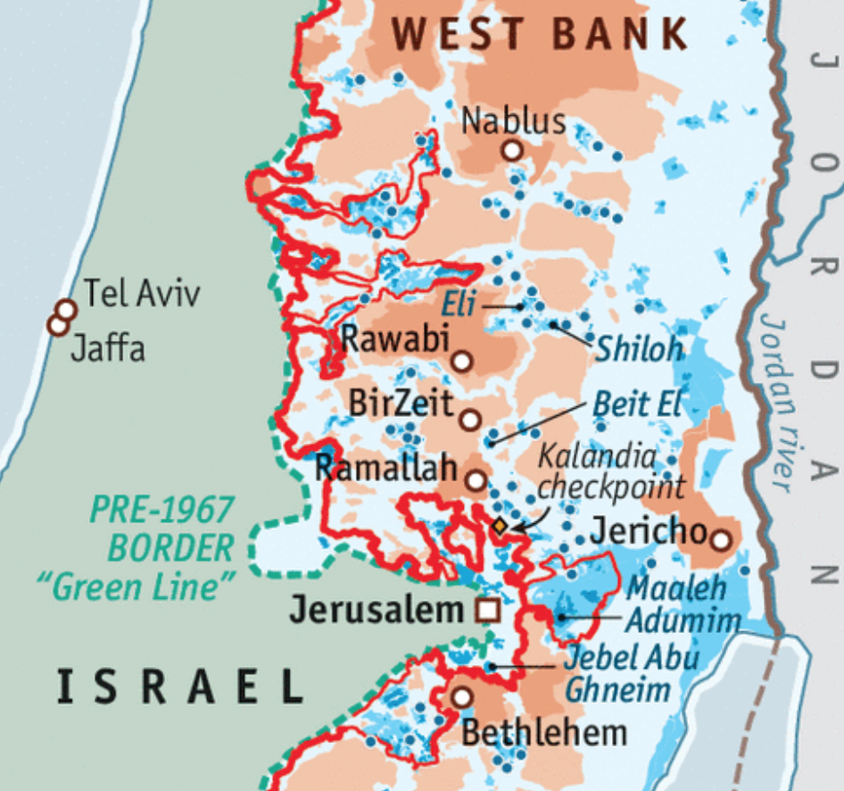
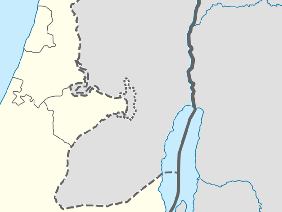
The trauma of the Palestinian who regards the concrete barrier is not, literally, on most maps constructed of Jerusalem or of the Holy Land.  Indeed, the trauma of excluding Palestinian presence in the city that the Jewish state has adopted plans to occupy fully, and the provocation of publicly acknowledging it as a capital, seems to seek to enshrine the trauma in maps.  For the boundary barrier expanded the line of Israeli control over the contested city–and even exceeded the territorial claims the so-called Green Line of the 1949 Armistice, or the pre-1967 bounds–but were never intended to provide a territorial boundary for the state.  If those bounds were treated as the new boundary of a national territory after 1967, the expansion was tired to be remapped by the progressive construction of the barrier or boundary wall much further in recent years, as if to over-write and banish earlier memories of settlement, and to stake a rewritten Israeli sovereign relation to the city, now provocatively defined as a national capital on maps.

THomas Coex:AFP Getty

Thomas Coex/AFP

At what cost?  The project of a unified Jerusalem will hardly conceal the deeply pained relation to the territory, however, and seems destined to only augment its military defense.  At this point, it may be opportune to return to the historical excavation of the pained nature of these boundaries–and the compromises that they create in the occupation of lands–is addressed in deeply psychological terms in Yehoshua’s Mar Mani, or Mr. Mani, which traces or excavates the ever-growing costs of such a divide.  The curiously retrospective structure of the five books of the novel peel back historical layers of mapping a personalized Jerusalem through the testimony or discussion with men in a family of Mediterranean Jews and their ties to Jews of central Europe, that throw into relief the intensity of a psychological concentration that takes the Holocaust as its justification for the fulfillment of a Zionist project for retaking the Holy Land.

The project of settling Palestine is seen through the eyes of the long stateless Jews and the ties they have staked to the land from the late eighteenth century.  While often cited as a justification for the existence of Israel as a state, Yehoshua includes the genocide of the Second World War in his novel about five generations of a family who settled in Jerusalem, but throws the history of their tortured relation to place in a far broader context of the ways that people have long pressed against boundaries, and indeed, confused their own personal boundaries with relations to barriers and boundaries that existed, were drawn, or were being redrawn on maps, even as they tried to use maps to navigate their relation to the city for their descendants.  Is the tortured relation to the city something that was bequeathed as a failure to define personal boundaries, and to understand the boundaries that might have existed between Jewish settlers of jerusalem and its inhabitants, that continued to inform either the construction of the wall that extends beyond the pre-1967 border line–

Jerusalem:Epicenter

–and the hard place of the wall that divides the complex expansion of the old municipal border of 1949 to encompass its Palestinian and Jewish populations, and the tortured relation each feels to its place.

jerusalem-demographic-map2

The border boundary that divides Jerusalem today as emblematic of an utter divide between populations, illegal and asserting itself to be a concrete evidence of the application of the law:  the boundary wall seems to deny any past habitation and any past, to create a new realty of borders, even as it seeks to affirm and inscribe a new divide in the city, even if under the pretext of protection from terrorist attacks.  But the broad historical conflicts of claiming Jerusalem as a Jewish city–even in the face of a Palestinian majority presence–and ruling it as a sovereign part of a Jewish state, rather than one the acknowledges its multiple ethnicities, conceals the tortured relation to place that is the result of denying any voice to its original inhabitants.

Building the boundary reminds us of the existential quality to any line of partition, and the deep effects with which it immediately effects the place and its inhabitants.  The wall, one might say, stares back at the man, sheer concrete without any sense of history or human habitateion, to protect the area extending past the Green Line as if to fix its future movement in the historically shifting map in stable terms.  This unstable map–which seems poised to be shifted once again, for national gain, in the 2017 annexation of the new construct of “Greater Jerusalem” including settlements along the West Bank, transforming a place previously without integrity to fulfill a prophecy of the “expansion” of the city as a part of the Jewish state, using a term of false if apparent neutrality to conveniently conceal and not account for the historical presence Palestinian inhabitants of the same place.

The wall is a remapping of history, and human habitation, after all, and a defense of claims by the Israeli state, built as if concretizing a timeless prophecy, and built as a timeless construction.  The remapping of space and the space of Jerusalem seems the subject of the e classic novel of A.B. Yehoshua about six generations of a Jerusalem family whose intent to throw the immediacy of the current conflict into historical relief continues to have bearing on the apparent absence of population in the retracing of shifting boundaries and the claiming of sovereignty over lands that, in the historical myopia that sees the utter tragedy of dehumanization of the Holocaust–or the condition of statelessness–as the fulcrum for its foundations if not the justification of its existence, but removes its borders and boundaries from history or from the land’s inhabitants, by cartographically declaring it to be an almost timeless truth of territorial advancement and an iconic image without need for an explanatory legend.

Shifting borders.png
Continue reading

4 Comments

Filed under A. B. Yehoshua, boundary walls, Israel, Jerusalem, national maps

The Arid Region of the United States and its Afterlife: Beyond the 100th Meridian

The map may not be the territory.  But it shapes one’s relation to the territory–and to the presence of water in the land, as well as the land itself.  John Wesley Powell had a clear idea of the importance of mapping the sustainability of his audience’s relation to the new nature of the aridity of the plains states and western territories in the 1870s, when he used his deep knowledge of plants and foliage of the region that was distinguished by a deeply fragile economy of water to try to convince the U.S. Congress of re-organizing the region’s settlement, in the face of increasing hopes for its development:   by bounding the area beyond the hundredth meridian west as the “Arid Region,” as if it were a truly unknown land, not subject to the practices of surveying rectilinear boundary lines that the had extended west along the Mason-Dixon line, Powell sought to convey a better understanding of the permanence of drainage zones of the region as the best possible ways of understanding and planning its process of settlement in the way that would be most helpful to future residents, boosterism of the importance of young men going west to find futures notwithstanding.

Indeed, the mapping of how the “Arid Region” of the United States could be settled by John Wesley Powell created as the second Director of the United States Geological Survey, a post he held from 1881–1894, but which he had first expansively described in 1878.  The United States Congress followed Powell’s recommendation to consolidate the western surveys into the new U.S. Geological Survey, and he long sought to create a map capturing the fragile water ecology of the American West.  The completion of his classic report on the region first suggested a new relation to the distribution of water in the region in ways that would best serve all of its residents, and in his later map, he tried to articulate so clear a relation to the region’s future settlement.  Powell’s view on the need for systematic irrigation of the region stands in almost polemic relation to the place that the western states held in the spatial imaginary of the Homesteading Era:  indeed, his insistence that led to the charge to undertake a systematic irrigation survey of lands in the public domain of the wester United States in 1888, long a topic for which he had agitated, and his map of the region reflected a demand to integrate a topographic survey, hydrographic survey, and engineering survey of the region.  Perhaps the map offered a new sense of the territory, if “territory” includes the waterways that would be able to adequately irrigate all open lands.

Arid Region of US

For the reception of Major John Wesley Powell’s attempt to map what he called the “Arid Region of the United States” reveals both he difficulty in mapping the relation of water to the land, and the appeal that a piece of paper might gain over time.  The detailed map provided something of a ground plan and register of how the arid region might be best inhabited, and of the relation to the land and landwater of a region’s inhabitants.  And it provides an early recognition of problems of water management and distribution in the western states–captured in its naming simply as the “Arid Region” as if to set it apart from the plentiful water in other regions–that later eras began to appreciate in ways that Powell’s contemporaries were less able to see in his ambitious attempt to reorganize the management of its regions around its multiple inland watersheds that he had hoped to canalize.  For Powell’s ambitious 1890 remapping of lands west of the 100° meridian in the United States tried to encompass their unique aridity and to pose a solution for its future inhabitants with special attention to its drainage districts–as discreet riverine watersheds.

Arid Lands Reservations
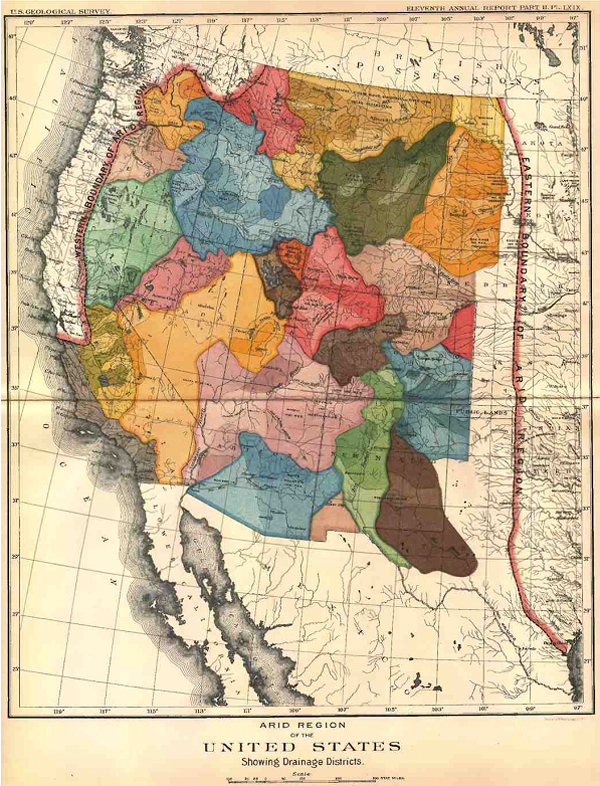
Arid Region of the United States (1890); detail
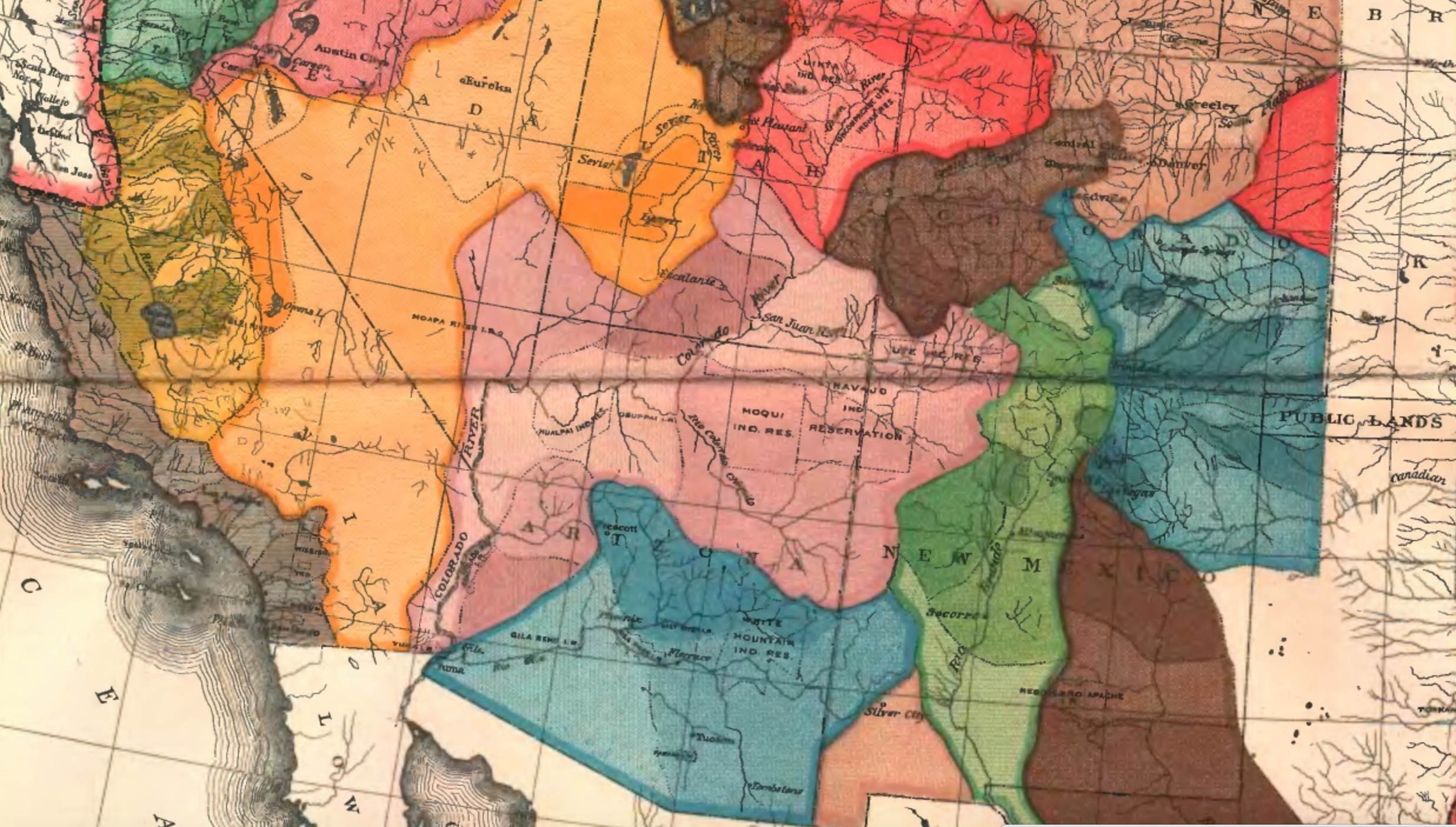
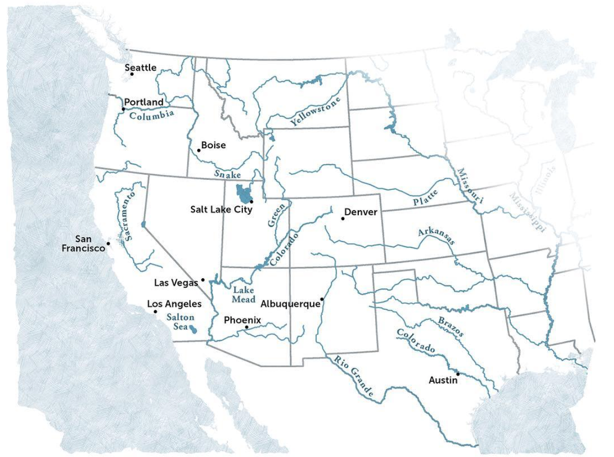
The best practices that motivated Powell’s map as a basis to orient the government to the land’s groundwater.  The distinctive scarcity of water in the western states became evident in a time of sustained drought, giving unexpected currency to how Powell’s map reoriented readers to the “Arid Region of the United States.”  The brightly colored map to which the explorer, geographer, and anthropologist not only dedicated an extreme amount of attention in his later life, and of which he became something of an evangelist, suggests a early recognition of the scarcity of water and its management, in an era when there is a specter of considerable anger around poor practices of water management in much of the western states, tempered by an expectation that groundwater would be available for farming and irrigation.

The rivers in the United States are quite widely distributed, leaving much of the western plateaux at a distance from riverine waterways–

Western Rivers.pngTim Sinott

–and the image of Virgin Land so deeply ingrained across that regions settlement that its unique character of low rainfall and widely dispersed water sources was erased in the spatial imaginary which replaced the detailed map Powell of the administration of groundwater in the western states that Powell had created with his surveying team as a guide to the region that he knew so well, and which he sought to communicate when he became second director of the United States Geographical Surveys (1881–1894).  The governmental office did not give him authority to organize , but to create a new map that might better organize the nation to the lesser rainwater in what was known as the Great American Desert.  For Powell attempted to re-orient homesteaders to the imperative of western migration through the map, by organizing water administration and the future prospect for canalization in order to grow prospects for the irrigation of the region and its future farmlands that have considerable ethical power to speak to us today.

Continue reading

1 Comment

Filed under arid region of the United States, data visualization, drought, environmental stewardship, water management

Melting Boundaries and Frozen Pasts: Anthrax, Globalism, and Climate Change

The first six months of 2016 brought the greatest increase in global warming in recent years, and a rise in temperature that far surpassed all previous records–and occasioned a rapid melting of polar ice challenging to map as well as to imagine in all its cascading consequences.  The 378th consecutive month of land and water temperatures far above twentieth-century averages, as per the World Meteorological Organization, became an occasion to wonder how “many more surprises are ahead of us”for the director of the  World Climate Research Program, and brought the arrival of strikingly new consequences of climate change with the unearthing of unmarked graves, as the once-fixed boundary to what had constituted the northern boundary of continents has begun to retreat.

A set of such surprises have already arrived.  The increased melting of what were once thought permanently frozen regions of arctic permafrost first awoke dormant but contagious anthrax.  While this latest development provided a note of panic, it seems only emblematic of the eventual cascading of after-effects that the melting of the arctic stands to bring, and of the difficulty to place them in any coherent narrative.  Yet while we use maps to organize a range of data on climate change, it’s also true that the emergence of anthrax in the Siberian tundra provides a poignant illustration of the “surprises” that climate change will bring.  And while the world has not known smallpox cases since 1977, the contraction of the permafrost stands to reveal extinct smallpox, and indeed prehistoric viruses of up to 30,000 years old, as cattle graves are newly exhumed from permafrost.  The last smallpox epidemic in Siberia dates only from the 1890s, but the buried bodies by the Kolyma river have appeared as if by unexpected time-travel with Smallpox DNA, raising the possibility of with the unearthing of riverbanks, and  sites of burial of both infected animals and diseased bodies as the ground thaws.  Areas infected with anthrax spores release by preternatural global warming are being cordoned off, but the revived viruses and spores may travel widely in water in ways difficult if not impossible to map.

As we seem to be opening up much of the north pole and an Arctic Ocean for multiple new shipping routes, in ways that have led to projections of expanding trade-routes with names that reference imagined passageways like the Northwest Passage, the imagined increased shrinkages and thinning of layers polar ice due to global melting are understood as opening up new routes to nautical shipping as ice retreats from much of the arctic regions–but which, if they were only understood in the abstract in 2013, are now becoming increasingly concrete in the range of consequences that can cascade from them.

Arctic ROutes.pngBloglobal (2013)

The arrival of a period of pronounced decline in arctic sea ice has produced a newly palpable intimations of the vanishing of what were once expanses of ice.

Figure41.png
Continue reading

3 Comments

Filed under arctic melting, Climate Change, climate change, global warming, mapping global warming, Polar Ice Sheet

The Imagined and Actual Geography of Brexit: Topologies of Social Anxiety

What sort of precedent did the Brexit vote sent for the validity of the demonization of immigration, and the growth of a firmly anti-globalist impulse?  The combination of a growing state security apparatus and economic insecurity on European boarders has created a fear of hordes and the arrival of migrants moving on foot that has created the now-dismantled migrant camp known as the “Jungle” near the port of Calais, not far from the Ferry Terminal for ships leaving for England.  This settlement became a site emblematic of the proximity of migrants to Britain in the summer of 2016, and helped to embody the fears of immigration close to the shores of England, giving a concreteness to the fears of immigration that deeply divided Britain on the need to protect its borders, and the dangers of doing so.  It was a debate about what being British meant, and where we draw our borders, which the Calais encampment, as the posters of refugees from Eastern Europe and Syria, illustrated with increased proximity.

Crossing to Calais on the Eurostar this summer, I looked out intently out of the rapidly moving train window for migrant camps who had been so central to the “Brexit” referendum by which  England recently left the European Union, that has held up to 6-8,000 refugees hoping to move to England–and some suggest the number reached as high as 10,000.  Indeed, as “Leave” seemed so successfully cast as an imperative, and “Remain” as the honest commitment to “Remain” seemed to have decidedly less media presence and staying power, the haunting residents of the camps, filled with refugees and migrants from Syria, Eritrea, Sudan and Afghanistan, if often left out of most maps of the election, provided a compelling if faceless specter for many.


f-calais-a-20160119.jpgReuters

_83530338_83530337.jpgBBC


The haphazard and improvised constellation of lean-tos, make-shift huts, and tents were ordered in streets beside orderly rows of fenced-off white metal shipping containers relocated to Calais to provide temporary forms of housing after their arrival.  Although there were not any migrant camps in evidence from my position in the train, the camps were in the past few weeks increasingly in the news, as the UKIP party that predicted an England inundated by refugee influx that social services and health could not accommodate, all because of England’s membership in the European Union, on the eve of Britain’s vote on the European Union Referendum–as “Leave” parties conjured fears of what belonging in the European Union would mean for the everyday Englishman in an age of increasing global displacement of refugees and cross-border traffic of men and women seeking work, education, and safety.  When the rapid train suddenly paused for unforeseen difficulties due to people on the tracks, one couldn’t but wonder how the halt related to those risking lives to enter the tunnel running beneath the Channel, whom local police quarantined in semi-permanent “homes” of converted shipping containers.

While the Eurostar connected two railway stations, and half of London and Paris was glued to the European Cup, the “Brexit” vote revealed a hiving off of about a third of Britain similarly eager to separate itself from the European Union–as voters voted, probably unaware of the consequences, in a plebiscite that trumped parliamentary politics in anti-democratic ways.  For Brexit became a performative mapping of a severance from Europe, in ways to manufacture an imaginary boundary between England and a refugee crisis.  The precarity of living in shipping containers now seems to be about as great as that of the European Union.  What was Jungle is largely destroyed, rendered uninhabitable save for the 1,200 unaccompanied minors who reside in the complex of huts, tents, and containers, as 4,403 migrants bussed to refugee centers across the country, to seek asylum, the settlement provided an effective threat of migration and effective specter of fear in the EU Referendum.  Indeed, it helped to ensure the surprising and unexpected success of a referendum designed to keep refugees at bay and finally withdraw the country –at significant national monetary cost–from the European Union for the foreseeable future.  As multiple fires began to burn in the Jungle after workers moved in to begin dismantling the camp, while some pointed the finger to refugees seeking to dismantle and erase the structures where they lived others pointed to British anarchists, even with the clearance began, so strong was the fear of migrants that the fate of 1,000 children seeking entrance to the UK is unknown, suspended by the post-BREXIT government of Theresa May.

English voters on the Referendum were presented with almost dizzying fears of immigration and declining social services that were impossible to visualize adequately.  In an onslaught that dominated the news and challenged voters’ attention spans and moral compass, “Leave” flyers used fear to mobilize against remaining in the European Union.  In a canny onslaught and bid for attention, reminiscent of right-wing politicians, flyers of  “Leave” raised the specter of fears of immigration policies out of control  and wrested away by a European Union whose member states stood only to escalate.  The eventuality of remaining in the EU was seen as an abdication of responsibilities, and a misplaced trust in Brussels to control the entry of refugees and Eastern Europeans seeking jobs into the UK:  if migration to the UK had grown to above a quarter of a million–“the equivalent of a city the size of Newcastle“–the arrival of two million over the coming decade mandated by “free movement of people”  conjured a suitably dystopian future.  Voting to Remain in the European Union was to accept this lack of control, and the subordination of British law to an over-reaching European Court; expanding the myth of foreign oversight of Britain, Leave claimed to offer the opportunity to check the flow of migrants to restore control to British hands.  The argument of empowerment may have been deluded.  But the powerful promise to return £350 million in taxes flowing to Brussels, and the prospect of immigration growth once such “candidate countries” as Turkey, Serbia, Macedonia, and Montenegro joined Romania, Bulgaria, and Croatia, to the tune of a cost of nearly £1.8 billion, provided a compelling rationale to vote “Leave” and to identify interests with the possibility of controlling the fair of the expanded borders of globalization alone, and rather than in the European Union.  As a movement of “faux populism,” carefully orchestrated to be effective at the ballot, the Brexit supporters stirred up fear into a central role in the election that attracted a growing range of supporters to the ballot.

The dizzying expansion of a region without frontiers was joined by a cry “to take back control” of England’s future.  The Referendum was presented as “our last chance to take back control,” a virtual mantra of the Leave campaign, and control “our borders” and international “influence” lest the nation be filled with immigrants against who one can draw no clear border.  With the Turkey, Serbia, and Macedonia joining the EU, ran the implicit message, Syrian refugees were bound to be waiting at the gates as well, without a compelling way to turn them back.


EU-523932.jpgDaily Express


Such a compelling framing of the debate about the nation’s compromised future in a landscape of expanding “rights” fostered fears of an end of public futures, “without handing our permanent control to people we cannot vote out”–as if the vote presented the last attempt at independence, ignoring the special relation of the UK had long insisted to the EU.  To be sure, the Leave campaign also increased regulations that the EU introduced, without suggesting other financial benefits.

The mapping of the response to the Referendum released a new plethora of maps in hopes better to explain the final vote of the plebiscite that precipitated the break from the EU.  Can these maps–and the mapping of social divides in England’s complicated tapestry of islands which integrate immigrants and regions where they still remain unknown, provide any insight in the difficulty to create consensus about the growing population flows that globalization has produced?  The question is important, because it suggests a new problem of political consensus not only in Britain and the European Union, but also in the United States.  For the unprecedented misinformed plebiscite gave voice to a deep unease with parliamentary deals that brokered the terms of England’s membership in the European Union, and with globalization, that dangerously undermined the responsibilities that the EU has gained to respond to the global threats of refugee crises–a role that has been foisted upon it by the economic promise Europe continues to offer as a zone without apparent national frontiers.  While we’ve been told by informed voices that the EU “had it coming,” whatever that means, or that the current European Union compromised British demands, or warned that the creation of social and political affinities could ever follow from enforced economic union, or give rise to public confidence, rejection by plebiscite of membership in the European Union subverted democracy, by a campaign bred from xenophobic fears and assertions the EU “has failed Britain” as a whole.

The recourse to demographic polling, hex bin maps sought to go beyond easy dichotomies, and unpack what seem deep-running fault lines within the country, and the difficulty of reconciling the nation given the increased political fault-lines attempted to process and reconcile divides in political parties that plagued the land.  But rather than suggest the complex lines of fracturing between the political mosaic of Conservatives, Liberals, Labourites, UKIP and Greens in England’s new political landscape, the Leave/Stay dichotomy revealed new divides in the body politic.

.

independent.png


Despite the many tired dichotomies that have been extracted ad nauseam from data visualizations of the EU Referendum–from old v. young, north v. south, working class v. metropolitan elites; educated v. non-graduates; identifying as “English” v. cosmopolites–the complexion that has redefined the country reflects a growing retrograde tendency of rejecting the status quo and belief in the benefits of hiving off that was undemocratic and displayed  a perverse nostalgia of deeply conservative roots.


Queen Backs Brexit!.png


The referendum that former Prime Minister David Cameron presented as a panacea or safety valve to staunch opposition to the EU in Great Britain encouraged one of the most badly informed electorates in memory to protest the entrance of eastern Europeans into the country, and the perception of economic malaise and overburdened public services, and erase the benefit of free trade accords and that led to considerable economic growth.  The economic amnesia Brexit provoked led to a massive rejection of the national government and indeed political elites, even when undermining their economic interests, producing the increasing likelihood that many wish to leave Britain even among working class groups in England and Wales, and many voters more angry about the EU government than aware of the actual impact on trade relations to Europe or manufacturing and health standards.  Although turnout was in general quite high, with 30 million expressing their opinion at the ballot box, or some 72%, the vote was predicted to be determined by turn-out, and the distribution of votes varied.  If most in Scotland turned out, many in London and in northern Ireland voting less, and many of the regions who voted to “Leave” turned out to vote intensely–and turnout markedly lower in areas with greater numbers of younger voters–who tended to vote to Remain in reflection of their economic futures, especially in areas with greater student populations in relative to their size.  But the appeal to the nation and national independence deeply obscured the issues on the table.


TurnoutBBC

brexit-map-1-1371x1200


What was Cameron thinking in opening up this question to a plebiscite that gave greater voice to those with stronger opinions, and indeed in opening up a question of particular complexity to a public yea or nay vote that hinged on turn-out?  Democratic “consent” to membership in the EU was long been “wafer thin” in much of Britain, and low turnout among the young gave a greater share of the vote to Brexit.  But the opportunity that the vote offered many the chance to decamp from the EU in ways few intended.  For during a refugee crisis, the cards were steeply stacked the party reduced to take “Remain” as its slogan, although the very passivity of whose construction suggested an absence of cogent arguments to respond to false promises of helping England’s shaky economy, persistent low wages, growing waiting times at National Health Service, and rising rents–all of which were represented as stretched thin by serving migrant workers and their families, and rising rents.

Partisans of “Leave” tapped such concerns so effectively that despite the value of data visualizations in anatomizing and describing the broad distribution of adherents mobilized behind a “Leave” mandate, the vote seems little understood or analyzed for its appeal as in its ramifications, and has created an ongoing puzzle about what place of England will now occupy in relation to the EU–or how the EU will look.


Brexit?.png


Continue reading

4 Comments

June 28, 2016 · 11:26 pm

Our Increasingly Overlit Night Skies

In the year 2025, a seven year old girl looks up at stars against the “deep, black” night-time sky, remembering that her stepmother as a child could once not see their “cool, pale, glinting light.  Octavia Butler sets the scene for her cautionary tale, Parable of the Sower (1993), a novel which glosses the spiritual journey of the believer by cautioning against the indiscriminate sewing of seeds in infertile ground.  The abundance of light in this possible world is an increasing reality.   The girls’s stepmother used two words–“‘city lights‘”–to come to terms with the radical changes of nocturnal luminescence wrought: stars grew so feint in the night sky they lost visibility in her own memory.  “‘Lights, progress, growth, all those things we’re too hot and too poor to bother with anymore,’” is all she was able to explain, in a post-apocalyptic tenor increasingly haunting today’s world, as the absence of darkness seems to have rendered starlight invisible in most of an over-illuminated earth.  

The memory, and public remembering of an era of over-illumination haunted many works of the era with good reason, as the world of darkness has receded into the past. Novelist Russell Hoban imagined the absence of all government in a post-cataclysmic world drowned in darkness in Riddley Walker (1980), set in 2437 O.C. (Our Count, dating from an atomic blast) but haunted by fragments of the scientific language that are shard-like memories of a world  lost to “counting cleverness,” which by “straining all the time with counting” eliminated of night–“‘What good is nite its only dark time it aint no good for nothing only them as want to sly and sneak and take our party a way'”–who “los out of membement who nite wer” as “they jus want day time all the time.”  Echoing current environmental concern for the ozone hole, Riddley bemoans the “harms what done in poisoning the lan or when they made a goal in what they callout the O Zoan . . . you can’t see it but its there its holding in the air we brave.” The difficulty of remembering or registering the scale of global loss, and the possibility of an absence of terms to ever know the geography of stellar visibility or dark. If the reparation of “memberment” tries to keep together a world where all government is reduced to the performance of Punch & Judy puppet shows, the elimination of night is cast as a precursor to atomic apocalypse.

Are we in the midst of a current era of the lack of remembering an era that not so over-illuminated by artificial gas or electric light? The apocalyptic nature of a loss of the darkness of the night is increasingly upon us, and long before the year 4347 when Riddley Walker appears set. For the many reliant on round-the-clock work, any border between day and night is increasingly obscured.  All-night work across the world have fashioned glowing landscapes of increasingly illuminated night skies, over inhabited spaces in over-illuminated lands may redefine an uncanny materiality of maps for the new millennium, evident in composite satellite images of an electrically illuminated world.

Goddard mediterannean at night

Nasa Earth Observatory/Composite Image of the Night from the Godard Space Flight Center

The notion of a “star-gazing station” that pops up along the highway may seem an improbability today.  But driving an hour and a half north from Toronto, just north of Napanee, one passes a Dark Sky Viewing Area, that offers the chance for volunteer-led star-gazing, where knowledge about viewing night skies are eagerly passed down, as if out of Fahrenheit 451, offering opportunities for amateur astronomical observation of geminoid meteor showers at the “most southerly dark sky site in Ontario,” where increased stellar visibility confirms that one has moved sufficiently away from the hyper-luminescent United States to “natural brightness” to view the Milky Way in all its glory.  The designation of “natural brightness”–or darkness–suggests a growing need to reckon with the geographical limits of night-time illumination.  North Frontenac, the Royal Astronomical Society of Canada   assures, offers surroundings suitably dark in fifteen km in all directions to be designated a “Dark Sky Preserve Status” for viewing night-time skies as they once looked.  The Star Gazing Pad invites all with telescopes in what seems a throwback to the popular astronomical observations of Victorian England. But it reflects growing anxieties and fears of the unprecedented skyglow and the augmented illumination of night time skies, where viewing stations are removed from major population centers. Astronomical observation in “dark sky viewing areas” exist outside of cities, near national parks, offering the possibility of respite from over illuminated skies.

Dark Sky Viewing Area.png

Dark Sky.pngLennox & Addington County Dark Sky Viewing Area

Driving north from the border today, one arrives on the 401 in “dark sky country,” as if a definitive passing of the border, north of Kingston and Lake Ontario, removed from the nocturnal glow of city lights, which promises to provide the “night sky experience very similar to what was available more than 100 years ago,” promising visitors the chance to “witness–perhaps for the first time [in their lives]–how the night sky is meant to be seen.”

N Frontenac

North Frontenac Dark Sky Preserve

Again, the question of the geographical boundaries of “natural brightness” and “natural light” are called into question by sites of such “Dark Sky Viewing Stations,” which have grown rapidly in Canada as preserves to “save the stars from light pollution.”  The United States was the foremost model for Butler’s cautionary tale of a post-apocalyptic future, when stellar visibility had only just returned, but only did after the decline of a world in which increasing artificial luminosity had long removed the stars from increasing portions of mankind.  

The vignette helped situate readers in a time just after a global collapse, where villages and cities are walled from roving gangs of drug-crazed marauders, and any semblance of security or infrastructure is gone from memory, and has faded into a past that few save the old can recall.  Lauren protests to her stepmother “there are city lights now” which don’t “hide the stars,” but the older woman is only able to shake her head in response, trying to summon earlier skyscape, and describe the changes that set the scene for the dystopia they now inhabit:  “There aren’t anywhere near as many as there were.  Kids have no idea what a blaze of lights cities used to be–and not long ago.” Lauren tries to recuperate an even earlier sill of reading the stars by an astronomy book that once belonged to her grandmother that allows her to decipher constellations she is now able to trace, and are newly visible in the night-time sky, using its maps as the sole means to be able to glimpse the stellar order seen in the night-time skies of bygone eras. Gas lighting was a memory of the past.

Henry David Thoreau pegged the confusion of night and day to the railroad’s expansion in mid-nineteenth century America, and to the expansion of the railroad outside of Concord. Amidst the spread of electricity, even in the unfrequented woods on the confines of town, traveling in th “electrifying atmosphere” “at some brilliant station-house in town or city,” Thoreau described the passage of trains as a new environment in their train of clouds and piercing whistle and defiant snort, acting as a giant plow amidst the countryside, registering the surprise with which even “in the darkest night dart these bright saloons without the knowledge of their inhabitants” as new environments. If this pollutes our language as “to do things ‘railroad fashion’ is now the byword,” the energetic coursing of the trains pollute his own senses not only by introducing light to the dark night where he is at peace: only after the train departs does he hear again the calls of whip-poor wills, hooting or screeching of owls, crying geese, or croaks of aldermanic bullfrogs of Walden, as if reacquainting himself with a natural sensorium of a living evening habitat that the train obscured. They return only after the retreat of any automated “path to the civilized world.” Far from the gas lighting that Thoreau had created a residence with “no path to the civilized world” in Walden Pond, even if it was with such a “deficiency of domestic sounds” that “an old-fashioned man would have lost his sensors or died of ennui” at the relative silence save squirrels on his roof, blue jays screeching, or a rabid or woodchuck beneath the house, finding privacy in a solitary life on a few square miles of forest, reclaimed from Nature, with “my own sun and moon and stars,” finding that even rare guests from the village “soon retreated, usually with light baskets [flashlights], and left ‘the world to darkness and to me,'” in an ideal of no light pollution that seems to have rapidly receded ever far away in time.

The night-time illumination of regions was tied to the introduction of the train. An animal of artificial invention, the train was a mechanical horse, snorting and creating a new environment of nature. Running across the countryside as a “fire-steed that flies all over the country,” a “cloud-compeller” that remakes its own habitat, stopping at “some brilliant station-house in town or city,” concealing the sun and leaving his own bucolic home cast into shade in its progress and he was awakened by its “defiant snort” in the middle of the night, erasing the division of day and night as it “penetrates my woods summer and winter. The progress of the train was, Thoreau suggested, to be weighted and considered a danger for the distancing of the world from nature, more than afford a support for civilization in the ability it offered to carry goods from all over the world to new locations, and provide odors carried with goods from “foreign parts, of coral reefs, and Indian oceans, and tropical climes, and the extent of the globe,” an effective precursor to the smooth surface of the transit of goods and open markets we tie to globalization. Concerned that there was “something electrifying in the atmosphere” of the train depot, where men “talk and think faster,” Thoreau invited readers to balance the improvements in punctuality the train provides even to farmers and the new compass lines it create perhaps obscure the path of fate in the air “full of invisible bolts,” as the individual is tethered to the relations of time and distance the train instilled.

Time Indicator, to Calculate Time Before the Standardization of Time by Charles Ferdinand Dowd in 1869

The rise of Railway Time by Greenwich Mean Time helped illuminate the landscape have accelerated to the premium on unelectrified unlit spaces of the present. In ways that give a new sense to “dark data,” techniques for mapping of the absence of light from an increasing share of the world suggest a new understanding of “place” that commands attention in multiple ways.  The Bay Area where I live can already be seen from the sky from the International Space Station, as photographed by astronaut Randy Bresnick photographed it in one of his final trips about the planet, that bear shocking witness to the expanse of populated lands that illuminate the growth of streetlights in the Bay Area, where intense luminosity stretches from San Jose to the Carquinez Bridge:

DQ45lruUMAAQUQW.jpg-largeRandy Bresnick/@AstroKomrade

The experience of the extreme intensity of urban blazing is echoed in the quite timely appearance of an atlas of night-time space.  The use of satellite maps to chart the extent to which artificial light has come to compromise the night-time sky over the past fifteen years.  For it reveals the global scale at which the growing impact of light pollution on the diminished darkness of the night-time sky not only around once sacred areas, like Stonehenge, but stands to change our sensitivity to the perception of starlight, and experience of a non-illuminated world.   At one time, the definition of astrological constellations provided a basis to organize time, space, and prognostication, they offered natural guideposts for maritime navigation–as the girl in Parable of the Sower seems to suspect, even as she struggles with the absence of many clear keys for their interpretation.  If Butler suggested the dark future of no stars in an alternate world of the future sometime shortly before 2024, by which time the dark sky has returned, we see little point of turning back in the maps of the over-illuminated world presented in the first-ever global atlas of light pollution atlas.

The atlas suggests we won’t so easily return to an unlit world–or at least won’t return save after a similar apocalyptic massive destruction of the over-industrialized world.  The recession of stellar visibility is only beginning to be fully mapped in full, but the ever-narrowing window of night-time perception of stellar visibility seems quite timely.  The global spread of man-made light pollution is the direct consequence of living in what historian Mathew Beaumont first described as “post-circadian capitalism” back in 2005– a condition where work-time is no longer governed by a clock, or biological rhythms of sleep, but both flexible employment and 24-7 economies have effectively expanded the working day to a continuous job, often enabled by continuous illumination. If Beaumont, following Jonathan Crary, has seen the sleep-deprived working worlds of the globalized world that denies the value of rest–or allows one to deny it–the attempt to process the global absence of darkness demands to be grasped as evocatively as Butler began. And one is pusehd to do so by a recent collection of the diminished global levels of starlight and stellar visibility, which invites us to try to survey what a sky without stars would be.

Continue reading

2 Comments

June 18, 2016 · 12:26 pm