Tag Archives: Manhattan

The Recent Resurgence of Manually Made Maps

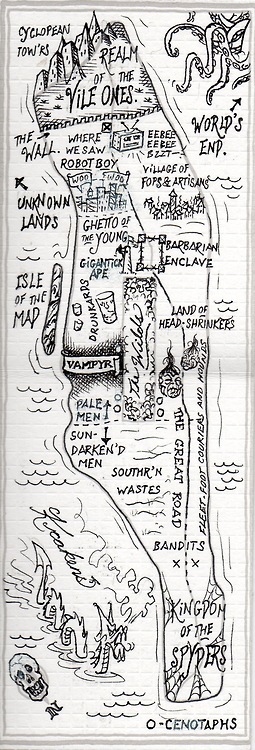
A somewhat celebratory survey of the recent rage for manually designed maps affords a veritable visual smörgåsbord of aesthetic pleasure and innovative graphical design.  It is interesting and tempting to compare them to the craftsmanship of manuscript maps, a subject discussed in an early post in this blog.  But the survey oddly makes little reference to the notion of the ‘counter-map’ that resists the omnipresence of the digitized map, and the manner we have come to be immersed in the traffic and generation of digitized maps.  To be sure, these are images suitable for framing.  But the appeal is in part a knee-jerk reaction to the satellite photo or the schematic land view.

In mediating a more fully stylized map of first-hand knowledge of urban areas clearly reacts to the increased hegemony of Google Maps–add your own business here!  map your way to work!  note your favorite coffee shop or restaurant near work!–as a plastic form of collective memory.  And, of course, a data resource on which Google can draw  in its own work.  The hand-drawn map is the map stripped of metadata and made without surveying instruments.  For the self-made map re-invests the format of mapping with a vibrancy and immediacy to enliven inhabited space once more–and indeed enliven the medium of the map that seems to slip out of our grasp as it turns up on our hand-helds, and even tracks our own habits of shopping, physical movement, data usage and cel phone use.  When we see the self-made map–and we buy them because of this–on Etsy or in the house of hipsters, we re-recognize places, and subscribe to how they define our emotional relation to space in ways that many other web-based maps make us feel more alientated.

If our memories are recorded in our maps, which note centers of interest, sites of pilgrimage, historical buildings, or public parks, the processing of how we track places worldwide in Google Maps is not somehow wrong or diminished, but has the sad effect of erasing any sense of specificity.  There is a display value of the map that is diminished from its reappearance on a tablet or smart phone, but also a dramatically reduced range of semantics or iconography:  it’s hard to imagine Charles Sanders Pierce, who enjoyed his spell of work on the conventions of map making and determination of spatial coordinates for the US Geodetic Survey, dressed in a neon shirt emblazoned with a corporate logo, using his expertise to boast of the benefits of Google Maps in tutorials.  The semantics of the Google Maps project is geared not toward innovation, but streamlined synthesis and ready access, after all.

And there is something of an erosion of display-value of the digitized map approximating Walter Benjamin’s concept of aura, since the refinement of data in digitized form approximates a concept of disembodied mechanical reproduction:  the emotional tie to the map is in a sense severed, the trace of the hand absent, the physical touching of the map’s surface gone.  These maps provide the clues and signs to reconstruct a mental map of place in one’s mind’s eye, rather than synthesizing the authoritative satellite composites whose clicks release downloaded data, but draw fewer associations from synaptic ties.  The focus of enriching the map’s metadata removes any trace of the hand.

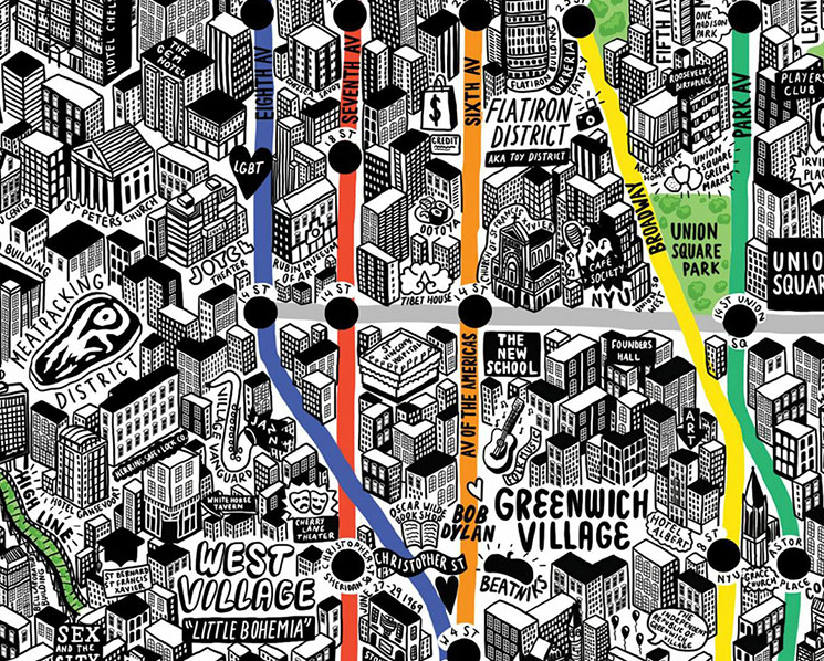
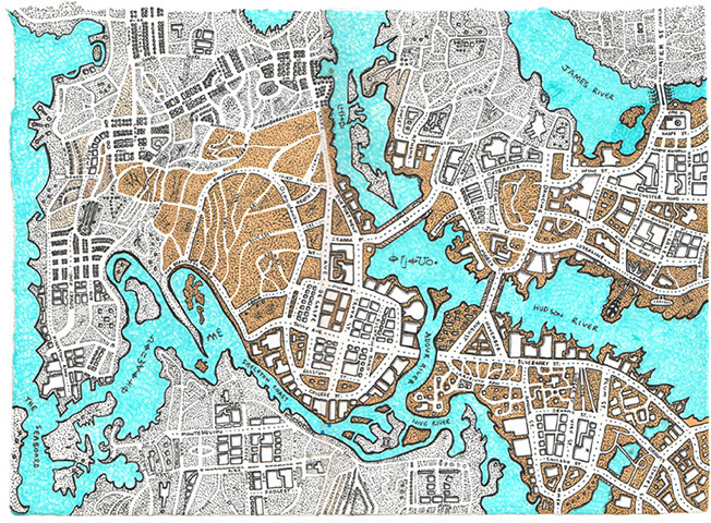
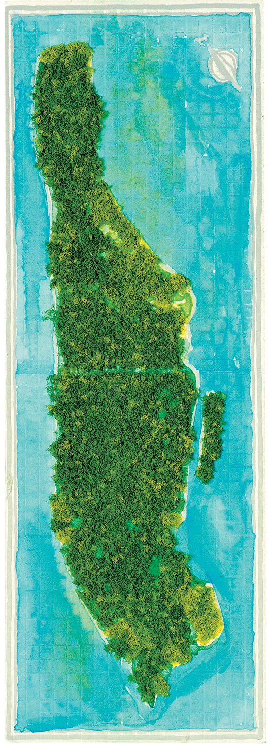
Mapmakers like the artist Jenny Sparks set out to recuperate the specificity in place that still exists and see the map as a medium to invite the viewer to explore.  While there’s a tendency to map a uniform green, Sparks’ comprehensive imaginary but copiously detailed ichnographic stark rendering of the collective architecture of elevated skyscrapers in New York in 3D, in ways that collapse street-view into a crisp crowding of built boxes.  The map, interspersed with memories and words, includes Bob Dylan on 4th Street; Beatniks in Greenwich Village’s Washington Square; and the Farmer’s Market on Astor Place, and is interactively enriched with text.   Sparks winks at the zoom function of Google in the elevated buildings  of Manhattan, each carefully drawn, and words that unpack the cornucopia of memories that the built space of the city holds, as some sort of metonymy for its residents.


New York map by Jenni Sparks


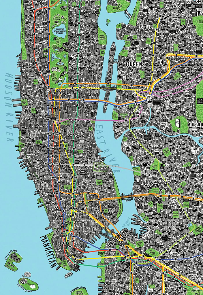
The pop-up three dimensionality of the map plays with the flattened two-dimensional view of maps, but suggests a bird’s eye view into which viewers can peer.  A few close-up details of Sparks’ self-made map of reveal how the skilled placement of words among 3-D buildings in her imagined elevated view draws you into a space linked or bound by the colored avenues of underground subway lines, peering into its so densely cluttered detail:


Close-up of New York map by Jenni Sparks

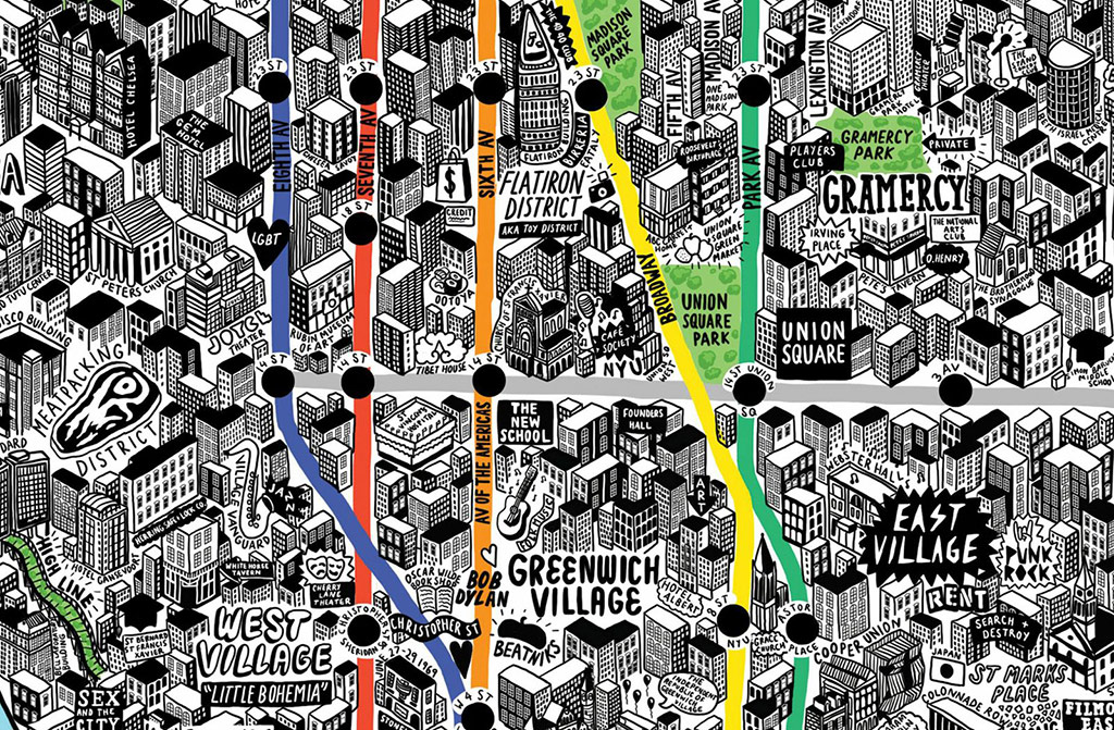
The closer one looks, the easier to see an image of place saturated with the visual interest that Google Maps just fail to afford, as one falls into the map in order to get to know its neighborhoods, suggesting a unique zoom-in function that the clumsy navigability of Street View only approximates:

Sparks' NYC


The rise of the hand-drawn map not only is a testament to design or a rebirth of a craft, but uses precepts of design to counter the vagaries of digitization Google so actively promotes, in championing the synthetic properties of a register of businesses, places, and personal routes.  I’ve written elsewhere, earlier in the year, about Becky Cooper’s recent anthology of the recent efflorescence of maps that personalize one’s relation to place, almost a collection of tools to encode personal meanings for a broader audience.  These images recuperate the aura of the map and its materiality, its hand-made status and both the physical practices of encoding place and decoding space.

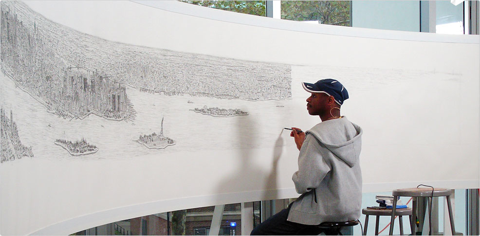
Something similar is going on in how Stephen Wiltshire draws Manhattan’s skyline from memory, lovingly attending the scale, proportions, and perspective views of each of the many skyscrapers whose sight so impressed Wiltshire on his first trip out of England that he promised to move to New York “in the future,” and claimed to have already designed his Park Avenue penthouse.  Wiltshire’s retention of and fascination with urban environments has been discussed by Oliver Sacks, and is the subject of Cities (1989) or Floating Cities (1991).  But his drawings are the intuitive opposite of a map’s abstraction of place by selectivity and spatial remove.


new_york_panorama_banner


Unlike Wiltshire’s intuitive renderings of urban space, the abstraction of space of a place underlies these hand-made maps, which sketch something like a hierarchy of relevance within their totality.  There’s a huge appeal in reclaiming the map as an intimate record of place, as well as an art of encoding meanings that encourage further examination, as this “mash-up map” based on the personal experience of Shawn Watts, and might be best described as his spatial experience of a long-distance relationship, compiling the places they had been together not only in his native Montreal, but in Athens, Washington, DC, and Philadelphia, as well as Montesquieu, France, and reflects his own deep pleasure in “hiding secrets in maps” as opposed to publishing information, and a pleasure in using the map’s form to map or be the surrogate for an interior emotional state:


Shawn Watt's Shutterbug


For Watts, the density of meaning in maps becomes a way to unravel and eloquently express one’s own state of mind in public form, and to invite the viewer to partake in the pleasure of decoding its contents.


Hope Mapped


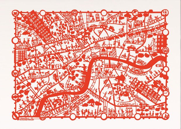
This somewhat but only partly legible hand-made silkscreen map of London comes in varied colors, populating areas with figures and words to approximate a paper cut-out hanging as much as a map:


553390_479276322084293_1624826968_n

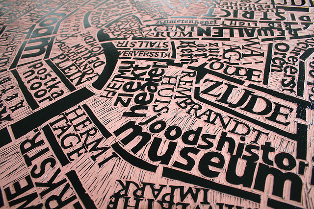
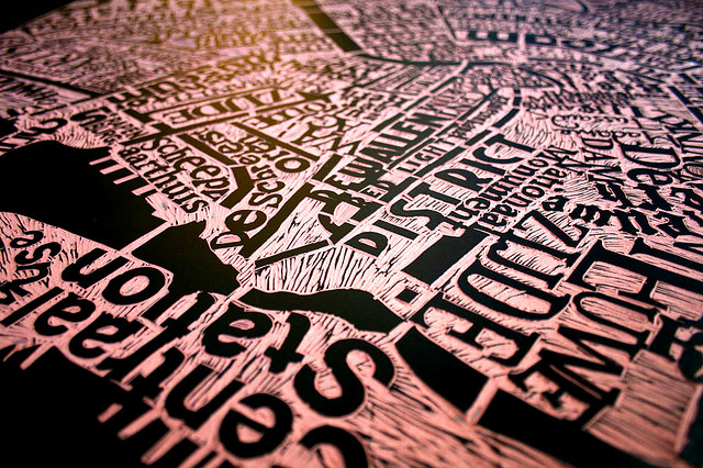
If these maps treat the map as an artwork, the trace of the hand on the map is even more present in the medium of linotype map, recalling Renaissance single-point engravings or woodblocks.  The linotype word-map Marc Webber designed of Amsterdam, a historical center or clearing-house for engraved maps, places front and center the words often absent from Google Earth or many digitized maps to use them to fashion a sculpted cityscape, whose linotype words offer something of an alternate surface to see the city in one’s mind’s eye:


Mark-Webber-Amsterdam-Map-120-x-100cm-Linocu-Print-on-Paper-e1331468741268


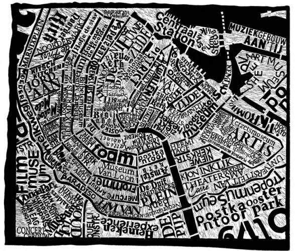
In Webber’s ‘map’ of Amsterdam, the written landscape becomes a site to explore and its very surface a sight to ponder; the texture of its woodblock words gains new textural richness as it is seen from different angles, from which the materiality of place-names on its linoleum-like surface increases in impact:


Amst Linotype-Looking at Map's Surface


Moving in to examine details more closely, the map assumes status as a surrogate for the world, as if the one-to-one map of which Borges dreamed or described is suddenly translated to words that substitute for things, as well as to the notion of a word-map:


centraal_station_wider


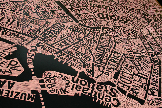
The Central Station assumes a newfound concrete prominence that transcends its place-name, without the curled Stedelijk Museum beside it, from a distorted view of this mapped space:
centraal_station_close


Somwhat more derivative or second-generation forms of manual mapping already exist on the market, as the sort of silkscreen word-maps popular in New York that maps the city’s neighborhoods, many of which are as much destinations as the city itself–and might provide a tourist map of realty.  If it is meant to evoke neighborhoods, it oddly recalls  real estate, even as its cartographical transcendence of space seeks to create something like a cascade of memories whose every words might serve as triggers, rooted within lived experience.


Manhattan word map


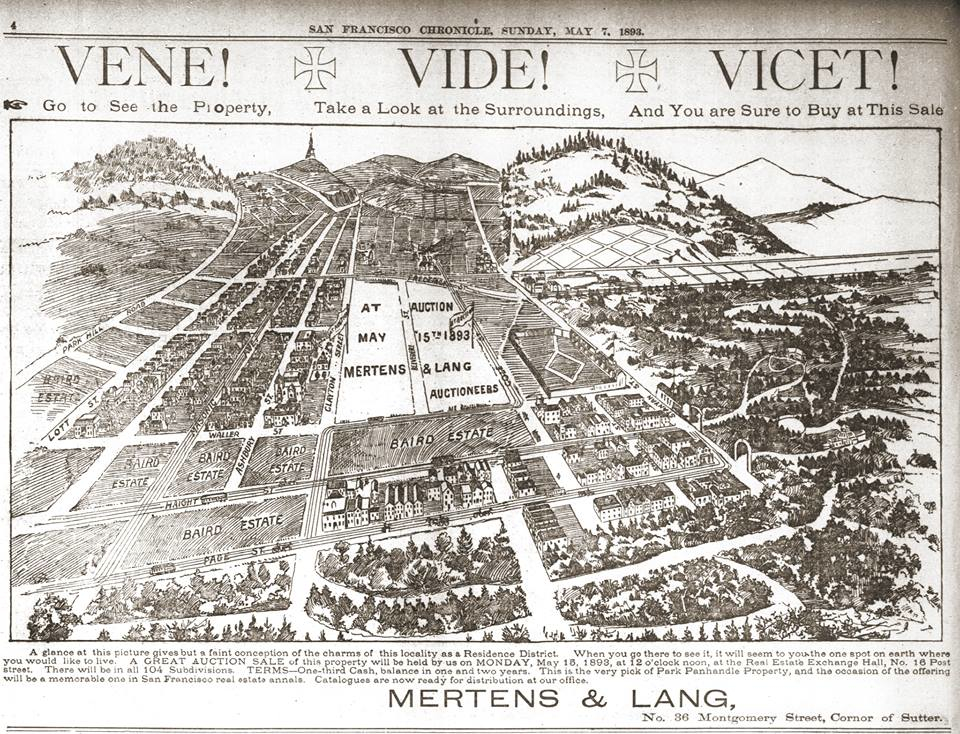
If the map seems a bit of a bare-bones realty map to the uninitiated in New York life, it is far less elegant and inviting than pictorial perspective views realtors employed of San Francisco to enjoin viewers to become settlers.


Vene! Vidi!  Vicet!


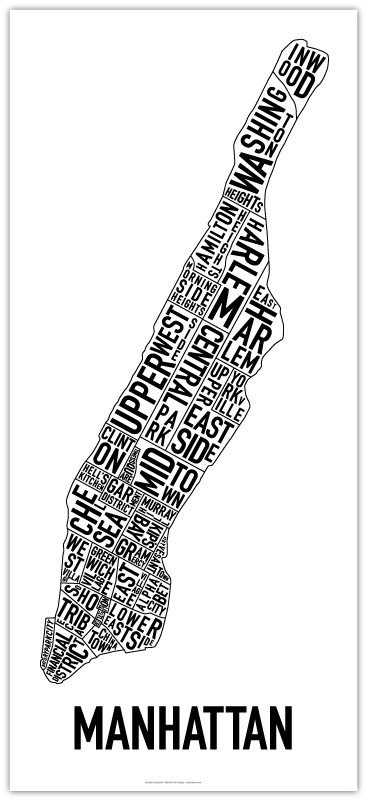
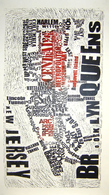
There’s far more detail in a linotype word-map of New York City.  The silkscreened map plays with the legibility with which maps use words to arrange space by surrounding Manhattan island with big, looming, isolated blocked fonts–inserting recognizable neighborhoods and cultural monuments in an what seems a more improvised mish-mosh of fonts from a printer’s tray, rather than from a pull-down menu, arranging the text to replicate what might better correspond to the place of regions within our mental geography, all the while emphasizing the extremeley crowded nature of inhabited space in New York boroughs:


New_york1


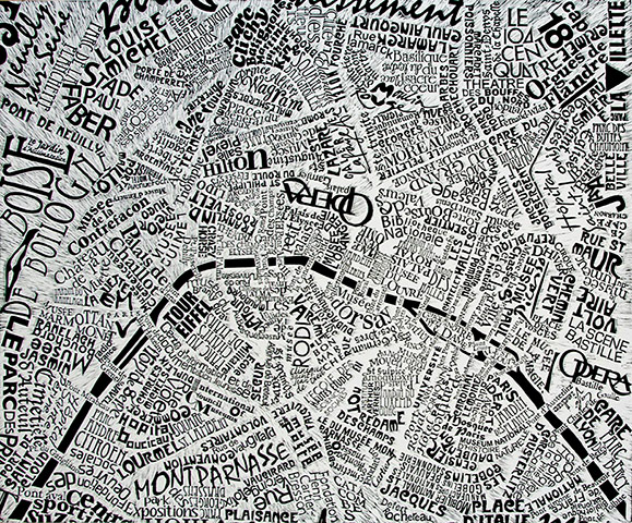
Sensitive as always to the particularity of place, Marc Webber’s quirkily detailed ‘word-map’ of Paris is more elegantly artisanal in how it fills the surface of the map, exploiting a range of fonts to arrange historical layers and tiers of class and style from the staid if impressive Opera to the lounging letters of Montparnasse, moving rangily down large streets.

Paris map by Mark Webber

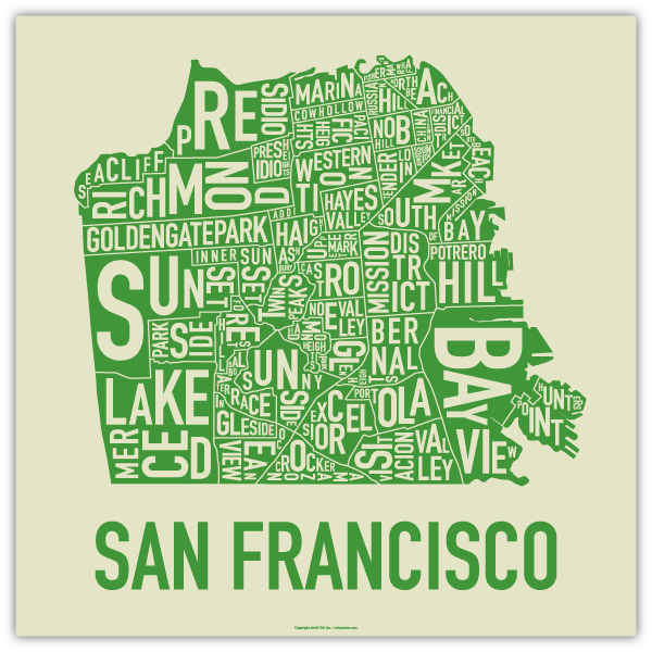
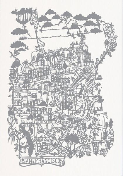
The written city is more demanding of a mastery of fonts, to be sure, since it also depends on the arts of assemblage; the word maps sold in the Bay Area provide a nice counterpart since its patchwork of its complicated topography is so impressively dense, and the only area of uniformity seem the Presidio or the landfill regions of Bayview:

SF Word Map GREEN

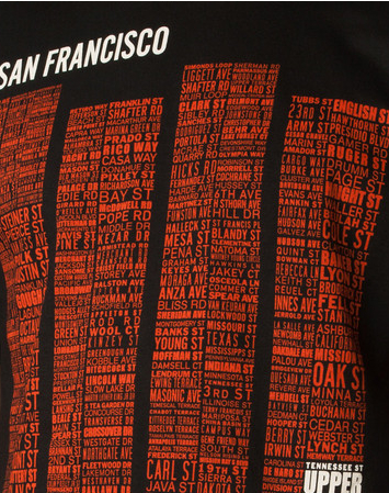
An alternative to this sort of mapping, illuminating the micro level of street-names, graces the design of one of Upper Playground’s t-shirts, suggesting the relative size of individual streets by their prominence in a list of names, that lends currency to the idea of the wearable “map”:

Upper Playground Tees SF name map

The diversity and unity of nearby Oakland is aptly captured in this patchwork roughly-hewn word map by Oakland native Ozan Berke of its 146 neighborhoods:  the jumbled density is almost rendered illegible by crowding, but with such dexterity that the artist/mapmaker uses to capture its diversity.  The density of some neighborhoods balance the urban intensity of some areas with the far more light settlement of the hills (Montclair, Sequoia; Claremont Hills; Skyline; Joaquin Miller):

Oakland Word Map

dD_Oakland_26x18-PR_2


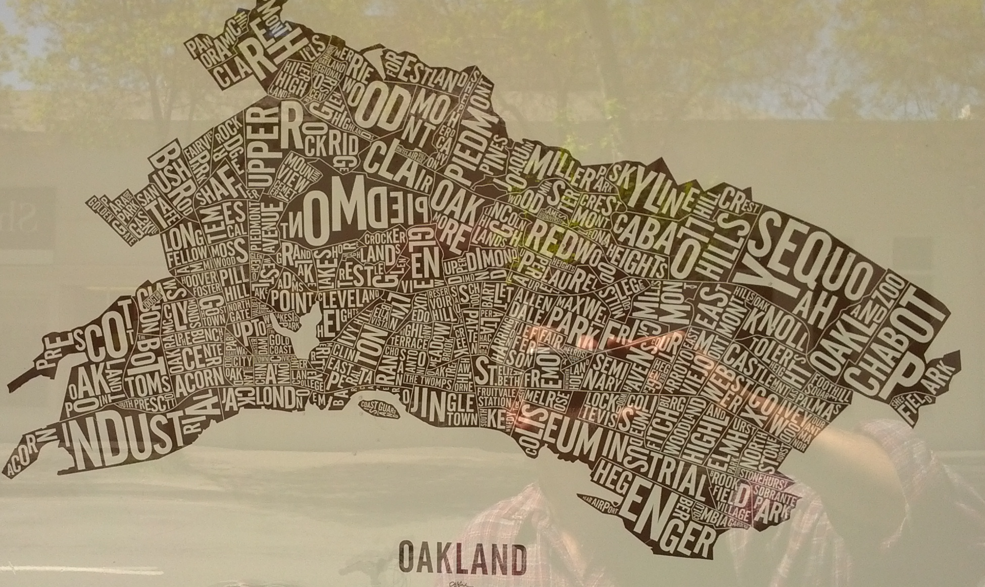
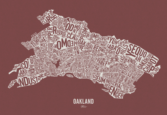
Writing the unity of the city in a sequence of place-names reconstitute the whole in a new form, as if by magical transmutation or an alchemy of type: this artist adroitly resolves the absence of the seceded largely ‘white’ village Piedmont from the city with the contribution that this town-within-a-city continues to make, writing its “name” as a neighborhood in mirror-writing, the “OMD” among the largest and most eye-catching in the map.

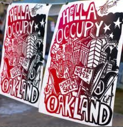
The declarative blending of words with place resonate with the politics of remapping popularized in the urgent signs displayed in the recent Occupy Movement outside Oakland’s downtown City Hall in Frank Ogawa Plaza to the iconography of the protest movement–mapping the helicopters that whirled overhead, but minimalizing their police surveillance to the upper corner of the map, and giving prominence to the placards that protesters held in front of City Hall–the scene at which these maps were sold:


Hella Occupy System Sucks

It is fitting to contrast the map to the elegance of San Francisco should be captured in the distinct media of a paper-cutting map, adapting the Chinese art of  Jianzhi (剪纸):

Paper Cut Out SF

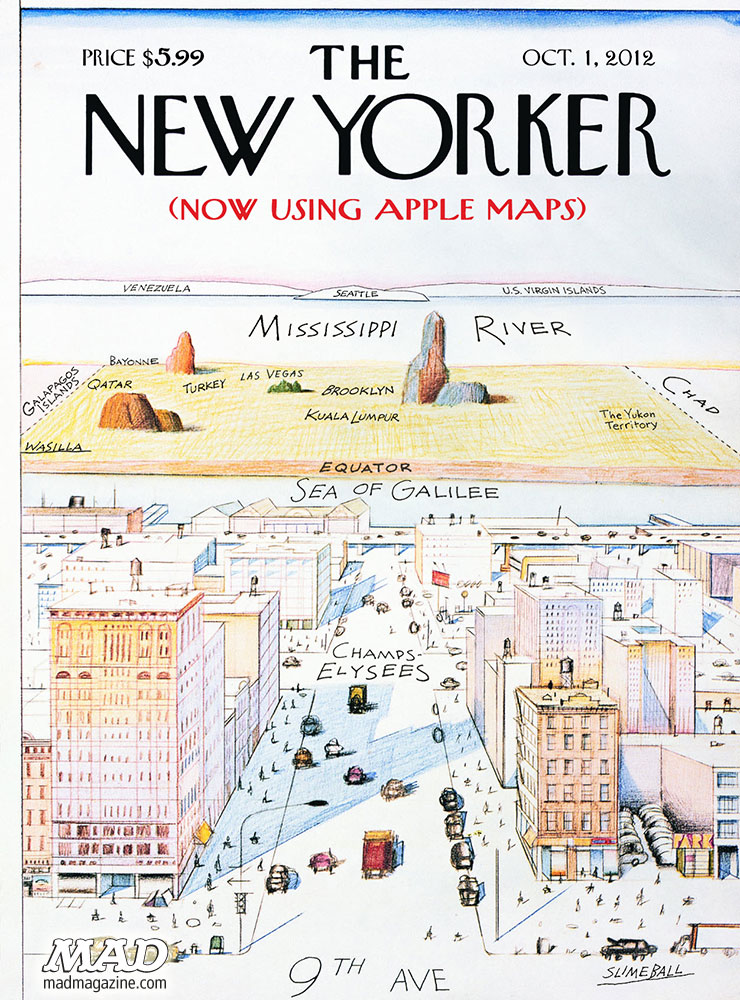
The remove that all place cartographical practice from digital media or design is central, I would argue:  the artist reclaims their own synthesis of a unified whole as the subject of the map.  All evoke the late Saul Steinberg’s over-reproduced map of New York, famous as a poster and originally a New Yorker cover, used to suggest the limited global perspectives of its residents or the centrality of the city in a mental map of the world.  That map has its response in the recent satire of Mad magazine’s “Slimeball” mismapping mediated by and poking fun at the recent failures of Apple Maps.  The revision of the classic Steinberg view of the New Yorker’s View of the World  plays with the spate of failures that app by calling attention to the radical disconnect between even a familair place and digitally mediated map, as if to suggest the depths at which we’ve been had!


MAD-Magazine-NewYorker-View2-2012


The growth of such a range of hand-drawn maps seems to me a reclaiming of place–as well as of mapping skills–that has come to gain a special niche of its own in the craft economy.  We are discontent with the proliferation of maps from which we are increasingly alienated–and which abstract information in ways confined to, say, only three viewing preferences.

There is still a possibility of changing less the digitized reconstruction of space than the notion of what Google defines as information, of course:   and perhaps the range of hand-drawn maps suggests some ways that this might be done.  The above view of New York, or rather its prototype, makes me wonder about maps that reprioritize the structure of information imposed on the templates of Google Maps:  a map, say, that would not note the Russian Tea Room or Trump Center and Empire State, but create historical layers of Automats, bodegas, Chock Full o’ Nuts, and 5-and-10 stores or the shifting confines of invisible ethnic neighborhoods in the city, and the impact of waves of migration.  This falls back on a map of memories.  And then, after all, it probably wouldn’t be hand drawn any more.

2 Comments

Filed under Aura, Charles Sanders Pierce, digitized maps, hand-drawn maps, Jenny Sparks, Jianzhi, linotype map, Marc Webber, Oliver Sacks, Saul Steinberg, Shawn Watts, Stephen Wiltshire, Street View, Walter Benjamin

Mapping Each and Every Tree

The “Central Park Effect” describes the interrupted avian migration that annually funnels a range of species of migrating birds into the trees of Manhattan’s Central Park. As they move along the great flyways of the eastern seaboard in search of a roost, the patch of trees amidst urban canyons of inhospitable anthropogenic landscape seems an area with something like habitat, whose edges offer a target to rest on a flyway that, by the time it passes the northeast Atlantic, is nothing if not overbuilt. If the park long held the space for repose on promenades and staged wilderness, birds have made it a home, amidst the anthropogenic landscape of the eastern seaboard offering far fewer and fewer roosting places during migration, recognize the park’s arboreal density as the last place to stop on a long trip north.

For the urban resident, the interruption is idyllic: the refugee from rural New England, Frank O’Hara, drank up the urban landscape he arrived in 1951, through his death, in ways that didn’t need more greenery than the Park offered him on lunch breaks. “One need never leave the confines of New York to get all the greenery one wishes,” he wrote, in dialogue with Walt Whitman’s poem that takes its spin from Brooklyn’s Greenwood Cemetery, while allowing that the city had made him so urban “I can’t even enjoy a blade of grass unless I know there’s a subway handy.” As O’Hara exultantly catalogued the hidden space of New York’s landscape, inspired by the movie houses, Manhattan Storage & Warehouse Co., and cavernous subway, the Park’s trees were enough, but also suggested about as much of the rural that he could stomach in his urban aphrodisiac that was the city that was the “center of all beauty.”

If the early trees planted tin the carefully landscaped arboreal island was hardly bound by built space, and wasn’t really an island, but modeled after European beaux-arts parks, filled the settlements of squatters in upper Manhattan–Irish pig farmers; the African American Seneca Village; gardens German immigrants presided over–with a monumental space of curated trees, whcih a hundred years after its founding had fallen into some state of delapidation, as huge towers surrounded its walled perimeter.

Few thought to catalogue the trees that now populate New York’s Central Park, the tide has turned. Back in the mid-nineteenth century, the expansive 1859 fold-out Visitor’s Pocket Guide to the park’s principle ponds, opened a prospective on the newly wooded regions of the park, taking time to caution visitors from disturbing the picking of any berries or flowers, as if it were a site of nature, lest they disturb any “construction, tree, bush, rock or stone.”  Its trees appear carefully situated in rows, and planted beside promenades, in stark contrast to the arboreal density today. The expansive seven-sheet fold-out map was probably based on the original pen and ink design drafted by Olmsted and Vaux as a proposal for an open, recreational space in the city, the Greensward Plan, with many paths not yet constructed and others eliminated by the time it opened in 1857, as a truly bucolic space for strolling, rather than the wooded enclave that the park has since become. The product of human work of construction of some 5,000 laborers–a miniature army responsible for paving, bench-making, constructing tunnels and bridges, lighted electric lampposts, and wiring, as much as planting trees, the luxury of the park displaced the squatters’ shacks that filled the region between Fifth and Eight Avenues, bound by 59th and 106th Street per the City Council’s mandate. But trees were hardly the planners’ main intent in imagining what they called a democratic greenspace, a curated wilderness that might substitute for the dilapidated sites for squatting of the unhoused on the then-margins of urban life: the promise of a “life in the woods” was built just three years after Henry David Thoreau had waxed as a tranquil remove from urban life in Walden (1854) would have been realized in curated fashion as a sense of “wildness,” if not of lake-like reservoirs, that urban residents fortunate enough to live near to could retreat.

Map of Central Park New York. Exhibiting the Drives, Promenades, Walks, Buildings, Ponds, Rocks &c. as far as finished up to July, 1859 Courtesy George Glazer Gallery

The process of the planning and planting of trees proceeded by the time of the detailed lithography that Lewis Prang seems to have copied it in a form–“thin paper to fold, heavy paper to frame”–he hoped to distribute among realtors of surrounding lots, revealing a park whose “every tree and bush, as well as every arch, roadway, and walk has been placed where it is for a purpose,” as Olmstead boasted, a space urban residents might wander removed from its grid, as if to find pastoral respite from the density of urban lives. The German-American engraver Lewis Prang who desired the work, who began a chromolithography practice after emigrating, later finding notable success in chromolithographs of maps of Civil War battlegrounds, including maps able to be interactively annotated by blue and red pencil to trace the progress of armies, completed this “picturesque guide through the whole Park” in June, 1865, as what must have been a celebration of peace-time, printing it in full color only some weeks after Civil War hostilities had ceased.

Central Park, New York. A Picturesque Guide through the Whole Park, showing all the improvements up to June, 1865

How to call attention to the variety of trees that have come to populate that unpredictable planned green space of Central Park, to catalogue its rebuilt pastoral? If the park was long seen as a site of danger in my youth, long a nocturnal site of cruising and unplanned encounters, the park planned around the Central Park is lauded for modeling the abundance of urban nature as if in negative to the built space of surrounding skyscrapers that roost around its edges.  

The way we map the park on the subway, indeed, suggests it is somehow magnified as a needed refuge for those to remember as they are coursing in cars that rumble on tunnels underground, far from any sense of open green: if the park is magnified in the famous transit map to afford a greater legibility of the tangled web of midtown lines that twist like branches or snake like roots of the circulating urban collective, it is important to remember that its lakes exist, even if its trails need hardly be mapped for audiences orienting themselves to public transit routes. We map the park, whose green provides a pause and respite from the grey concrete facades of buildings, as well as a site for strolling, by a flat lime-green interruption of the urban grid in our public maps, as if the park was an abrupt interruption of the tan city blocks, cool blue ponds creating a shared space of reflection in a landscape dominated by private property and expensive residences. And there is a sense of lack, perhaps, or wanting, that the cartographic silences of that pea-green space open, like a yawning opening traversed by busses along curved horizontal line, set apart from the urban grid.

IMG_0436

The subway map affirms, in a weird remove from the rider who is traveling underground, a removed oasis of sorts, ringed by a tan frame of muted buildings–as if a place to experience wilderness, or a curated sort of wildness.

Created in the parks movement that redesigned urban space removed from unsavory elements and moral lassitude, and restored as a reprieve from the pace of urban life, the rebirth of the parks as open green-space has recently occasioned the first complete census of individual trees, those often uncounted inhabitants of Manhattan island. And each tree has been mapped, in recent years, to allow one to voyage through the space of planned trees, migrants, and recent arrivals of conifers and other volunteers, joining the staid oaks, elm, and London Plane tree.

The trees have been counted in Central Park, unpacking this light green space in an enumeration or ‘green census’ cartographers Ken Chaya and Edward Sibley Barnard created.  The result is a deeply ethical way of directing our attention to urban space, in a comprehensive map of the tree space often rendered as a stretch of undifferentiated lime green.  Indeed, the counting of large-trunked oaks, maples, individual pines, and sturdy sycamores in all their varieties offers a detailed abundance that is rarely evident in the parks maps that adopt a single cool shade of idyllic green, and offer a sort of palimpsest that will reward map-readers to pause over, examine, and explore–and indeed pore over, with the botanical level of detail and connoisseurship that the earliest planners of the park might well have appreciated and enjoyed–if not expected of city-dwellers.

Who wouldn’t have expected as much from urban sophisticates?

image

Map of Central Park: printed for the Department of Public Parks, 1873 (detail)

Yet today, the often-internalized map of the park of light green, far more familiar to all city-dwellers, may risk perpetuating an alienation from its dynamic urban forest, and obscuring the careful level of its botanical detail, or the accumulated palimpsest of urban habitats of its biodiversity. The vivid light green of most maps of Central Park may be muted, but seem rendered almost life-like in the rain–even if green is a generic “greenspace” it is one to be valued, and walked around on its circuitous paths, a space that is a distinct interruption of the equirectangular grid of the built city, and a respite from its straight lines and sheer heights.  One can see not urban canyons, but the sky.

Green aPark

In part, the duality of Central Park as rural and urban captures the hybrid identity as an urban park.  Even though the park seems to lie somewhat incongruously at the very center of Manhattan, as if the apparent preserve of trees and urban wildlife is defined by its porous relation to the urbanized setting of the park.  If Central Park was designed in the movement of urban greening and public space, as a site of health and interruption of urban life, the park is increasingly more of a heterotypic combination of urban activity, designed built spaces, and manicured wooded areas, a refuge where Manhattan is in a sense perpetually present, not only bur urban sounds, traffic, and lifestyles, in a dyadic relationship that seems captured by the fact that it offers not only the sole open space to inscribe the toponym of the island in subway maps.

In such maps of urban transit, it may be that Central Park acts less as a park, than it serves as a totem of urban space; the park holds the bold-faced word “MANHATTAN” that identifies the city, its flat green spaces and clear light blue lakes crossed by ribbons of white roads, indicating its nicely settled position as secure in an urban grid, as if fastened by crosstown routes, yet readily available to urbanites at multiple entrances as a site of repose.  The image of the interruption of urban space we encounter on subway cars with regularity reminds us of the existence of open green space which we can access, even while we ride in eardrum shattering rumbles of subway cars coursing on old tracks while winding one’s way downtown to one’s destination.  Is it an important reassuring reminder of the existence of open spaces that are in fact accessible, even while we may not feel it, nearby?

IMG_0436

The combination of nature and skyscrapers was a unitary construction, several ecopoets have observed, a conundrum or urban nature explored by ecopoets who take up the gauntlet that the urban spaces throw down.   When the poet Gary Snyder described his arrival in New York City, he evoked an ecosystem blending nature and culture that began form its trees and moved settle throughout the island’s sidewalks, streets and skyscrapers, even as it clung to the edges of its shores.  

John Bachmann, “Greenwood Cemetery, near New York” (1854), and detail

If the winding paths of the park were built as a space of democracy, modeled after the popular Garden Cemetery Movement of such exemplary success in the creation of Greenwood Cemetery as a preeminent public space of trees, winding roads, lakes, and monumental graves in Brooklyn–the trees and wooded regions central to its appeal.

The sense of the showcasing the green space of the park had declined considerably, of course, by the 1980s, when Gary Snyder admired by the crowded built environment of New York as an ecosystem–or rather as a “deep ecology”–in “Walking the New York Bedrock,” careful attending to the juxtaposition of its trees in the steel skyscrapers of its overbuilt financial hub. The ecosystem was vibrant, but removed from wildness, if oddly emulating it in its crowded urban density upon its paved grid and steel and glass towers; helicopters like insects “trading pollen,” above skyscrapers competing for photosynthetic abilities, sirens coursing through its valleys and paths of subways like lichen rooted underfund. Snyder sung the collective recreation of a lived connection to living landscapes, the Central Park Conservancy was in its early years. The dolomite and schist that provide the basis for the actual “bedrock”–the basis for the rich growth of foliage across the island, and support offered its ecosystem–resting atop a thick bedrock of metamorphic Hudson Schist, marble, and dolomite.

Snyder has meditated on the human relation to the built as a retraction from the wild in The Practice of the Wild (1990), which flippantly denies the vital sense of the wild in human life. Snyder wrote about the built the connection to the lived landscape that Snyder located in its wildness that remains in many natural environments was increasingly restored and retained in New York, where, as Snyder noted “there is nothing unnatural about New York City, or toxic wastes, or atomic energy…,” the trees which introduced and whose presence punctuate the poem were foregrounded in Central Park in the very years that Snyder wrote and following decades. The Conservancy has done much to call attention to the range of foliage of 20,000 trees whose foliage–Red Maple; Hickory; Sugar Maple; Scarlet Oak; Red Oak; Dogwood; Star Magnolia;–it keyed with classificatory precision–

Map and key of fall foliage via Central Park Conservancy

–to bring the space into crisper detail for us, and to attract us into its surrogate of the greater wild.

An abbreviated catalogue of a parade of urban trees–“”Maple, oak, polar, gingko/New Leaves, “new green” on a rock ledge“–are the starting points for Snyder’s urban walk on the. bedrock in Walking the New York City Bedrock (1987) that capture their dissonance with the “gridlock of structures,/ Vibrating with helicopters,” in an ecosystem populated by businessmen or by “Cadres of educated youth in chic costume,” coursing in the subways and paved surfaces under which run subways, the lichen or spiderwebs of the urban ecosystem. But the restoration of the wild within the built environment of the city are celebrated in the recent atlas of the parks trees. For they have been allowed to congregate as an interruption of the built environment, but also as an ecosystem in it.

The “park” was long promoted as the primary shared green space in the city–and a space where city-dwellers retreat, at times, to smoke some green stuff in a meadow or on a hill, the definition of the park as a set of individual trees has rarely been mapped in detail, examining the arboreal space that inheres within this interruption of the built environment–if only to excavate and explore its complex past.  For Central Park was built as a site of public promenades, a planned space akin to the popularity of the mid-nineteenth century Garden Cemetery movement that had led to the landscaping of urban areas as tranquil grounds of rest, designed within the city as sites of visitation and at a contrast from its commerce.

Walt Whitman, when a newspaperman, often entertained readers by the pleasures of knolls, rivers, and trees in faux rural Greenwood Cemetery that provided the illustration of Garden Cemetery in New York City by 1854, whose paths provided a sense of prospect over the harbor and winding paths, lakes, and hills among its monuments, that he inimitably exhorted all to visit, a combination of cultivated plants and open space John Bachmann crafted a perspective view in a tinted lithograph, inviting viewers to survey its planted trees and cultivated plants, as well as plains of grass and planted fields–

–that encouraged the viewer to detect the cultivated scenery of trees and plants as if to recall the praise of Virgil’s ancient Georgics to agricultural cultivation of a bucolic preserve where “in the woods the almond/Lavishly blooms so that her boughs bend low,/Fragrant with blossom,” beside where “the crops will be/Lavishly rich as well, with the great heat/Of the great exultant threshing following on.” Amidst trees burgeoning with leaves, “and therefore over-copiously shady,” the park as the cemetery would offer a place of rest, as much as work, where “Among the cultivated plants/Darnel and tares and sterile oat-grass thrive,” the overgrowth cut back with pruning knife to nurture and reveal a well-tended oak tree, juniper, cypress, spruce, willow, Linden, beech, almond, following proper precepts of cultivation to reap the benefits of sewn seeds in the properly tended imperial landscape.

If Virgil’s paeon to the benefits of agricultural labors of planting, binding, threshing, plowing, and tending are recapitulated in the precepts of harvesting and care for the land to present a rich visual landscape in which the reader is immersed to enjoy its benefits, the range of trees, both planted and arriving by chance, have since created a landscape to be decoded by the map of each tree that the park currently contained. Drawn by hand in laborious attention to each detail, but now available as an app for easy assistance in navigating the park, the green monochrome of many maps springs to life in lists and individual detail, so that one is able to pan and zoom close-up on trees while one is navigating it.

The range of trees that now fill Central Park have been mapped by Ken Chaya and Edward Sibley Barnard in Central Park Entire, a detailed poetic catalogue that itself presses thresholds of cartographic creativity, individuating tangled ecosystems of planted trees, forested areas, native plants, evergreens and new arrivals that are mixed within its landscape, moving easily to a “tree list” that provides an easy way of orienting oneself to the multiple species inhabiting Central Park, allowing users to scroll, pinch, and zoom into individual regions and, when geolocation is enabled, to be oriented to wherever you are. Users can find the names of each of the 20,000 trees in the Park, based on Ken Chaya’s two years of surveying each tree in the park’s hundred and seventy arboreal species.

Even if the landscape was built on granite and was defined by concrete and brick, the trees defined its space, however paradoxically, in ways that capture the serendipitous presence of the arboreal variety in the city  “Maple, oak, poplar, gingko,” ecopoet Gary Snyder mapped New York’s trees in syllabic feet, “New leaves, “new green” on a rock ledge,” taking the arboreal collage on Manhattan’s bedrock as a metaphorical ecosystem, an artificial reef of the human scheme of the “Sea of Information” filled with streams of “keen-eyed people,” “cadres of educated youth,” howling sirens, and squirrels, that peregrines sail above, whose gridlock opens like a sea anemone of which wind sends a shudder that “shakes the limbs on the/planted trees” beside “Glass, aluminum, aggregate gravel,/Iron. Stainless steel.

The poetics of these long lists of urban inhabitants survey an ecosystem in a new form of rhapsodic evocation of their heterogeneous admixture of natural and artificial between paved concrete urban spaces. If Virgil praised farmers, Snyder celebrates the varieties of urban trees and pavement encountered in “Walking the New York Bedrock in the Sea of Information” (1987)–an island whose gods are capitalists, where the lavish overgrowth of plate glass windows shine beside the gleams of white birch leaves, a built and natural congeries where culture and nature overlap.

A modern Whitman, Snyder embraced walled urban canyon walked by curb and traffic light, counting trees among built space seamlessly, from ginkgo trees of Gondwanaland or built bodies to the pictographs and petroglyphs of subways, beside cable and pipe, erasing any distinction of natural and artificial, as “beautiful buildings we float in, we feed in,/Foam, steel, and gray/Alive, in the Sea of Information.” Snyder’s metaphorical recasting of the urban ecology is an ecstatic wilderness, underpinned by a tabulation of trees that echoes, in contrast of the natural and the built city how Herman Melville described the city in mid-century exultantly as “belted round by wharves as Indian isles by coral reefs,” but naturalized the built walled canyons where sirens echo streets as a built landscape where urban trees and wildlife abound. 

Continue reading

1 Comment

Filed under American poetry, Central Park, New York City, open space, urban parks

Self Made Maps

Many online responses to the arto-carto project of Mapping Manhattan remind us of how the biggest challenge of any cartographic totalistic idealized view is to record local details with fine grain: it’s no coincidence the chorus of posted responses to the maps in today’s New York Times often complain about the loss or absence of specific individual neighborhoods, or the absence of economic diversity (and ethnic diversity) in the beautiful colored maps.  As an exercise of collective map-making, the project that Becky Cooper ideated and planned, “Map Your Memories,” provoked each cartographer to record their own view of that island, rendering it as inscribed with memories of their own.  This open call perhaps provoked the deep-seated nature of responses it has met, evident in the energetic nature of good-hearted responses Mapping Manhattan has elicited from online readers over the past few days.

map_2

The call to “Map your Memories” asked a range of writers, artists and other would-be cartographers to record individual memories in the outlines of a map of Manhattan island of vague north-south orientation.  The book stands on its head maps’ implied claims of objectivity, by treating media as a screen to project memories, whose individual design reveals their topography to be imprinted with haphazard collections of personal associations or reminiscences.  The white upper-class basis for these mapped perspectives  is implicit in their subjects– lost gloves, volumes of Proust, chick-lit, cups of non-Starbucks-brand coffee, lovely one bedroom apartments, or stages of urban fear; the maps are something like open invitations to play Proust.

They are rightly, and also wrongly, criticized as upper-class white bourgeois artifacts, since that is what they openly are–no one would presume to credit them or mistake them from objectivity.  (That might not be the audience that the New York Times wants to address, but is after all the audience of Abrams, the art-book publisher.)  The playfulness of some of the maps clearly perpetuate these myths playfully transform Manhattan to echo something like a medieval zone-map, where torrid zones of uninhabitability, and in fact are divided by zones where the mapmaker would never set foot or know:

map_5

In quite a few, boundaries of class are visually thematized and reified with a certainty familiar from  the medieval “here lie monsters,” or Odyssean sea-monsters, or an edge of the earth from which one might easily be able to fall . . .

tumblr_mibz79u24w1qzbevlo1_500

These maps celebrate the artifice of cartographical fiction-making, reading more like the maps of Jules Feiffer and Norton Juster, or of the sensibility of that great medievalist JRR Tolkein.

I prefer to read other maps as a range of responses of common DIY creative reactions to the plague or deluge in most of our big media of weather maps, visualizations of databases via GIS creations or simulations, where detail provided by surveying is lost or filtered out for a schematic view of the whole, reactions that are apparent in their sheer cartographical abundance or ecstasy of naming with which each cartographer is offering a map of their own.   I see a sort of reaction to the dramatic diminution of the art of the cartographer in Google Earth or the Weather Channel, where big color-drenched screens, sometimes over-saturated with details or more often just clotted by hues to signify climactic variations or cloud-cover, replaced the selective criteria of mediating topography or settlement via cartographical art. Such a diminution of the act of creative cartography is, after all, an imaginative failure, as much as a shift in cartographical media.  Contrast the abstraction characteristic of many GIS-generated maps to the abundance of local meanings that distinguish the series of maps that Cooper has assembled.  There is a joy of celebrating the individual that has led so many of the online comments to beg for their own memories to be inscribed in the maps, as well as those of the authors.

This is evident in the visual celebration of the mapmaker’s art in the lovely watercolor map submitted by Markley Boyer, one of the few historical imaginations, of the imagined bucolic past of Manhattan as a field of green, surrounded by a sea of blue.  This map most reminds me of the impact of the tools that our cartographers use, as much as their level of artifice.

map_0

In this material remapping Manhattan as a lost Eden, the author of Manahatta: A Natural History of New York City, has reclaimed the artifice of map making in richly saturated colors and applied sponge.  This Manhattan of the mind is mapped at several degrees removed from the actual inhabited island–as are all the maps in this volume–but the degree of artifice by which it stands at a remove from the island reminds us how much all mapping records the relative richness of a vision of self.

5 Comments

Filed under Becky Cooper, Feiffer Map, Manahatta, Mapping Manhattan, mapping memories, Markley Boyer, Proust