
In the Bay Area, where I live, the danger of the new firescape is so pressing, and so impossible to process, that we can only digest it as a danger that is ever-present, akin to living in an active seismic area, but we cannot process in a static or dynamic map. But this is an area of risk that we are living cheek-by-jowl beside in ways that are truly unfathomable. As the power shut-off zones have been expanded in clearer detail by PG&E in response to the growing gustiness of winds that threaten to compromise the safety of residents as well as the aging electric infrastructure of the state, we are oddly haunted by past promises to maintain or upgrade our national infrastructure–the promise to rebuild national infrastructure was itself an energizing call of the Trump campaign–only to be demoted by being assigned, with improved veteran care, the opioid addiction, workforce retraining, and the Middle East peace to Jared Kushner, in ways tantamount to moving it to the way back burner, soon after being mentioned in the State of the Union as a non-partisan issue in January, 2018.
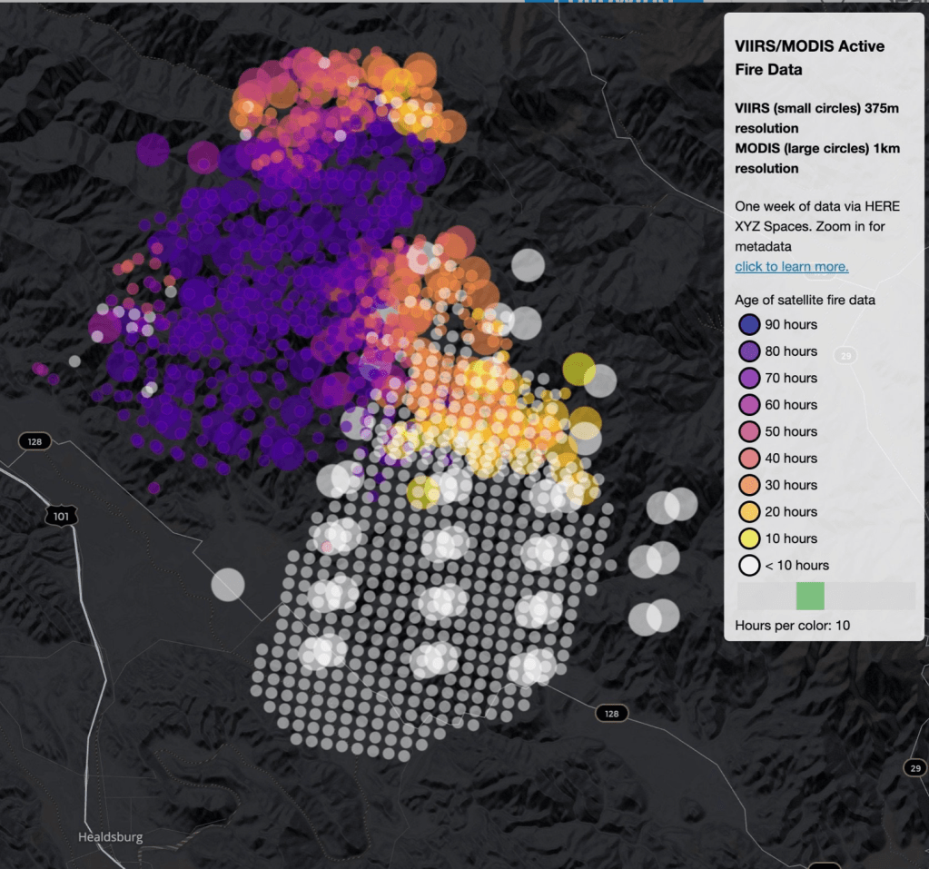
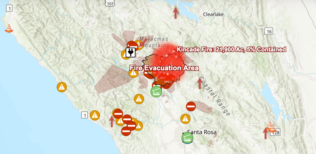
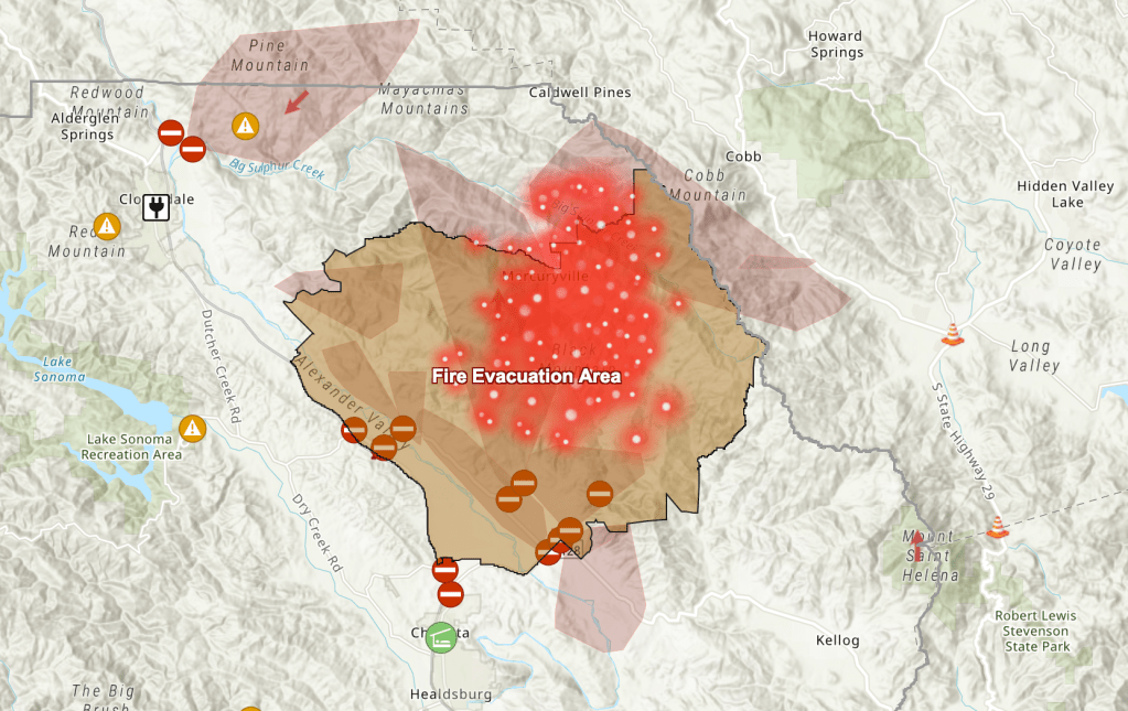
And yet, the spread of fires with increased rapidity, across landscapes that remain highly flammable, has created terrifying imagers of a highly combustible landscapes, where the recent growth of fires–in this case, the Kincade Fire that did began only long after the shut-off policies began–chart the spread of fires across terrain multiple times larger than cities, moving across the landscape rapidly, driven by unprecedentedly strong offshore winds: the passing overhead of satellites charts its expansion.
We are immersed in a landscape of emergency, that only calls attention to the climate unpreparedness of the state, and the risks specific to high fire dangers–even if some of the regions that have since burned, from Vallejo to Sonoma, were quite recently seen as of only moderate risk.
And so, emergency shut-offs of electricity and the expansion of potential power shut-off zones across the state, ranging across thirty-four state counties, as potential shut-off zones are planned to extend to Yosemite and Stanislaus forests, from Napa and San Jose, entering the shut-off map into our spatial imaginaries of contingent outcomes of the fire season and forest fires, as another spatiality the contingency of climate change introduced to our mapping tools.

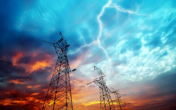
The strange maps of the edges of forested areas reflects the expansion of residential areas beyond cities, or on the urban peripheries of the Bay Area, where above ground power lines have been extended by a privately-held power agency that accommodated new customers by often outdated equipment, where increasingly high levels of voltage are coursing along lines to meet consumer needs, as customers are advised to consult a regularly updated web map on the PG&E site, as some two million are left without power throughout the state in late October.
Were these maps maps of public safety, or were they maps, as most suspected, of liability, reflecting the new stakes of corporate liability that PG&E was trying to come to terms with in a new age of firestorms? The heightened danger of fires set off multiple mental alarms across the state, as the California State Utilities Commission creates their own maps of fire threats–on three tiers of danger–that provide something like a guide to the occurrence of power shut off warnings from the privately owned utility, itself now in bankruptcy. For the threats arrived, as if in a new measure of fire seasons, only shortly after the utility had filed for Chapter 11 bankruptcy reorganization, itself in debt just under $35 billion, desperate to retain the financing it had secured from capital management funds who seem to have under-written our fire safety preparations.
The announcement of proposed shut-offs seemed most immediately an attempt to register liabilities–and cover them, reflecting a recognition of the liability that PG&E has been forced to shoulder in the aftermath of its bankruptcy. But the maps, more deeply down, reflect awareness of the deep technological unpreparedness of how to confront a situation of extreme weather in a world when fire threats stand to asymptotically increase in the increasingly overdry landscape of Northern California. For even as the state has exited multi-year drought, the compounded presence of high winds, a ravaged landscape of previous fires, and aging electric transmission lines and towers only rarely updated or secured.

But is the landscape of power shut-offs only a distraction from the deep lack of preparation for climate readiness across the state?
Do the maps PG&E has distributed of a new geography of power shut-offs, only distract the nation and PG&E customers from the lack of preparedness for a landscape of extreme climate change? As gustiness grows to eighty miles an hour, or slows to sixty miles per hour, can the spread of fires be prevented? Turning off electricity, and not allowing internet services to be accessed by people near the fires’ paths or affected by the fires’ smoke, seems an odd strategy that the utilities company has embraced. The outages shuttered 874 of California’s cell sites, which lack electric backup, reminds the FCC, hampering communications statewide as well as the communication of emergency services–raising challenges across wildfire country of spreading calls to evacuate without internet-enabling cel towers, phone lines, charged computers or lighting.
In an era when we depend on emergency communicative networks for public announcements, by digital fire alarm, it is unconscionable to trigger shut-offs on cell towers and cause networks to fail, as towers lack any adequate back up energy supplies, from wind or solar energy photovoltaic cells. There were past models–seventy-seven cell towers were knocked out of commission in Santa Rosa in 2017, as just under 350 sites went offline, and yet no adequate plans for electric or transmission backups was in place. (Cellular providers had tried to outfit water towers companies as backups, and Verizon, T-Mobile and Sprint all said they had plans to continue service during outages from batteries and back-up generators, but network performance did not follow through.)
The roll-out of shut-offs began from a set of maps of outages and potential shut-offs, as if to assure their proactive response to the fear of fires. The eerily odd maps seem to erase the actual topographies of fires from view, or allowed any on the ground assessment of climate-based strategies.

The increased gustiness of winds generalized a sense of extreme fire danger, reminding us of the broad state of fire in a drying state, where rainfall has created a rage of fires across the state. But the rise of liability in California for fires that have begun often from the collapse of insecure transmission lines and aging electric infrastructure has created a sense of palpable risk–risk not of individuals, but for a private energy company that have reconfigured what the scales of justice will looks like in a landscape where loss of property, homes, and lives are increasingly memorable consequences of increasingly destructive fires, where PG&E has accepted some responsibility both for the failure to secure towers or power lines that have been struck by limbs, and sent sparks flying into dry branches, brush, and unwatered grass, and even agreed to rebates to both commercial and residential customers for costs of blackouts or power shut-offs. Yet can the image of justice be secured or preserved in a landscape when Los Angeles Mayor Eric Garcetti is ready to describe the fallen branch that struck a transmission line in Brentwood as “an act of God”?


Obi Kaufman has compiled the following fearsome image of fires across the state in a rather fierce map in water color, which belies its medium, and the watery surface. Bleeding reds picture the spread of fires across the states’ counties more concretely than the best remote sensing can achieve–and suggests how fires have increasingly shaped the topography of the state–raising the deep, primeval fears of fire as a plague of contiguous burning regions across the state, as if its entire surface is lit by fires that bled into one another, moving across space in record time.

Numbers of residents displaced by the fires over the last five years in California stands as a human rights crisis, particularly acute among lower-income residents of the state, often displaced by loss of homes which leaves them without options of relocation. Because most communities in California wait an average of five years until homes are rebuilt after fires subside, the increasing occurrence of “wild” fires in the state significantly increase the income divides, diminishing the amount of available housing stock across much of the state, and increasing the cost of rentals after fires have been extinguished, and creating a new part of the ever unstable landscape of California, many of whose residents already internalize and accommodate fears of earthquakes, at least for those who have made peace with the instability of fault lines.
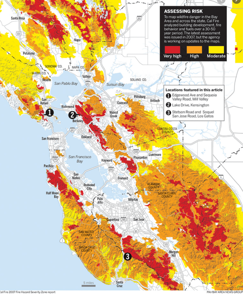
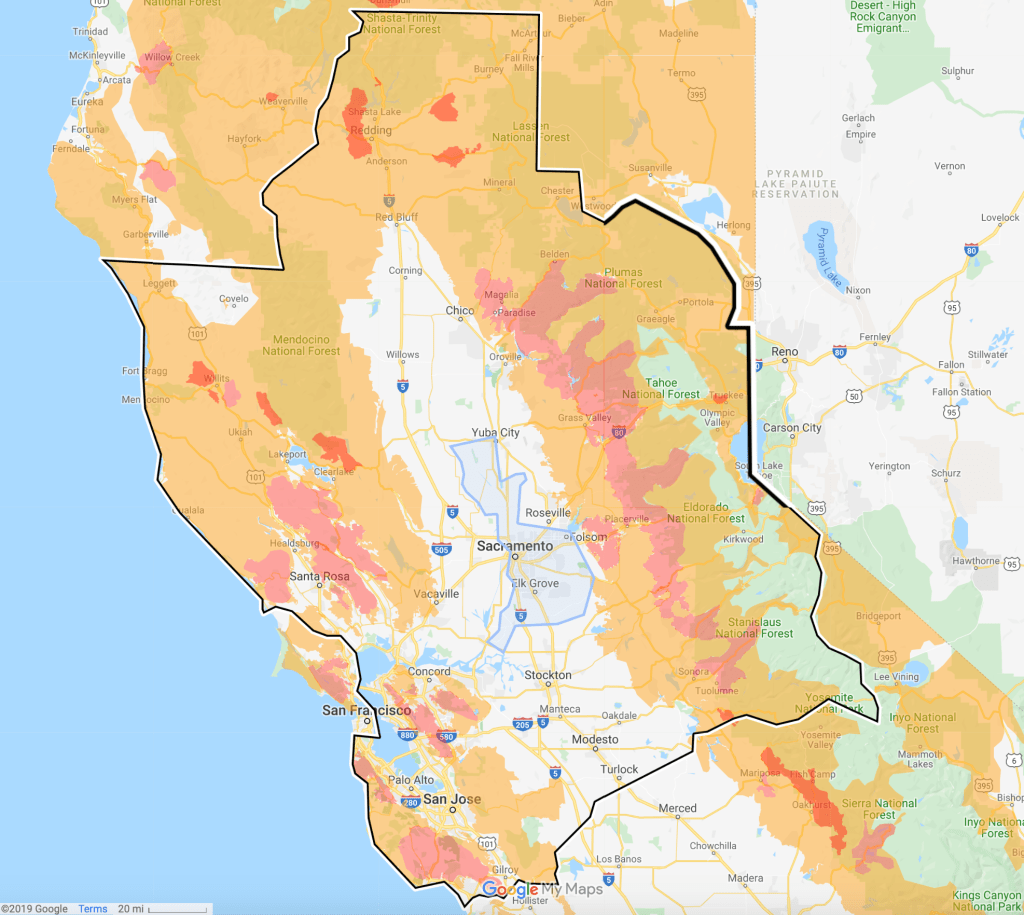
Was it possible to review the areas of greatest vulnerability, by turning to the levels of gustiness transform the levels of elevated danger of firestorms spreading across the state, too determine what areas were endangered–identified but the misnomer of “wildfire hazard,” even though the fires endangering the state originate in the woodlands-urban interface.

The dangers of wildfires spread across the more densely forested areas, but the diffusion of risk seems liked to gustiness, in ways that made me think of wind maps, usually used on wind directionality, devised from NWS data. Although their elegance is far more easily aestheticized than thought of as the bearers of spark-driven fire, or include the increased levels of gustiness that are hitting northern California and the southern coast, approaching eighty miles an hour, a velocity that engineers built transmissions lines that were entirely unprepared to confront.

But we might make so much sense in a map where the site of gustiness statewide, were geared to but one user, and the evidence of a new sort of mapping of wind danger, rather than value, ground temperature, and infrasgtructural vulnerabilities,, as if to create the possibility of a new global view of world wide wind velocities. Could one imagine an interactive wind map of the region, focussing not only their velocities but tyremrperature, by different colors, beyond the ways Viégas and Wattenberg’s Wind Map suggests the sinuous streams of winds, as a “delicate tracery of winds over the US,”to suggest a set of hidden contour lines? the map that uses HTML on a JavaScript database from the National Digital Forecast Database in real-time could be used as a tool beyond computational design, to map the intensity of gusts and their temperatures in a state-wide manner, and indeed to vie the intersection of heightened wind currents with transmission lines, as we process the eventuality of spark-driven fires?

Let’s return to that wind-map for a bit, as these images of flames are so damn intense to be difficult to process, and we need to relax our eyes to appreciate where we are.

The Javascript and HTML coding of wind flows, westerlies, and hurricane by Fernanda B. Viégas and Martin Wattenberg offers an almost chilly aesthetic remove of wind flows nationwide, as if a new national weather map of extreme contingency: it helps illuminate the contingency and lack of preparedness for gustiness ranging to new highness in northern California,within “the delicate tracery of winds flowing over the US,” as they put it on their website; the wind map that is adopted by many companies to visualize the weather is a record, as Viégas and Wattenberg put it, of the “invisible, ancient source of energy [that] surrounds us–energy that powered the first explorations of the world, that may be a key to the future,” of significant power; could it be that it also illuminates the danger of energy dependence on electricity?
One must read the map of the occurrence of fires in the past five years is also a map of displacement, and pressures on public housing, and of the increased salience of a public-private divide afflicting the local economy and all residents of the state, and standing to disrupt the common good more precipitously than property loss can map: the occurrence of fires around the so-called urban-wildland interface, areas of intersection, where many seeking housing are also pushed–outside of Sacramento, San Francisco, and Los Angeles or San Diego–creates an apocalyptic scenario where many of the suburban residential areas are consumed by raging fires, displacing residents who will find it even harder to find a home.
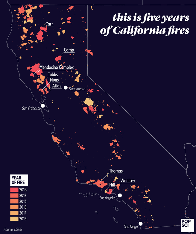
The mosaic of the fires seems an impossible challenge to process or parse. But it suggests the impossibility of removing the range of fires that have occurred in the last five years form the cities where populations are concentrated in California, and indeed confirms the surreal nature of how a sustained absence of precipitation has ringed the capital with hugely destructive fires, which despite their individual names suggest the new landscape that tightening resources in the state are compelled to address, both in prevention and mitigation even as the costly nature of controlling what has been an almost year-round fire season creates a budgetary costs few have prepared for: the costs of fire protection, emergency awareness, shipping of fire supplies, makes each fire particularly challenging to map, even as it is increasingly clear that the fires can be mapped, in a truly disheartening way, on how transmission infrastructure intersects with the power of winds of Brobdignagian proportions, from the dry downslope Santa Anna winds that reach the coast of Southern California from inland, at ever-heightening temperatures and velocities, whose increasing strength fan fire dangers in coastal foothills of the southland to the dry Diablo winds that rush in from warming deserts in the north.
The unpreparedness before these heightened winds, drying atmosphere, and the heightened terror of spark-driven fires that suggest a landscape we are both unprepared for, have no resources to meet, and will only increase counter-charges and name calling by state officials who attack the corporate greed of PG&E in reflexive ways so formulaic to be tantamount to a madlib, leading Governor Gavin Newsom to re-narrativize the shut-offs as an attack of the corporation against the state–disdaining the power agency’s unpopular shut-offs “a story of greed and mismanagement, of recklessness and putting profits before people”–rather than raise the specter of the crisis of climate change, and the lack of an infrastructure that is able to accommodate high winds:
for the very winds that might produce greater hydroelectricity, paradoxically, lie at the causes of the specter of the spread of spark-blown fires, downed transmission lines, and vulnerability to electric shut-offs and to fires, and indeed the destruction of property and the massive unpreparedness in the face of catastrophic fires capes that will bring increased numbers of refugees inspired by climate change to northern California, as we face the proliferation of new “evacuation zones” in the face of fires, and normalize the devastating landscape of climate change..
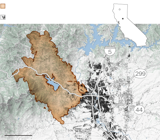
As we face the proliferation of new fires, the image of new evacuation areas that radiate around the Kincade Fires that have spread beyond 76,000 acres remind us of the dangers aging transmission lines pose, but that an Arc map can only show as a ghost inhabiting the land, difficult to reconcile to it, or a bullet hole that global warming has sent into the state map, tracking its “radiative power” outside any clear story but the rather panicked assembly of overlays of polygons of evacuation areas.

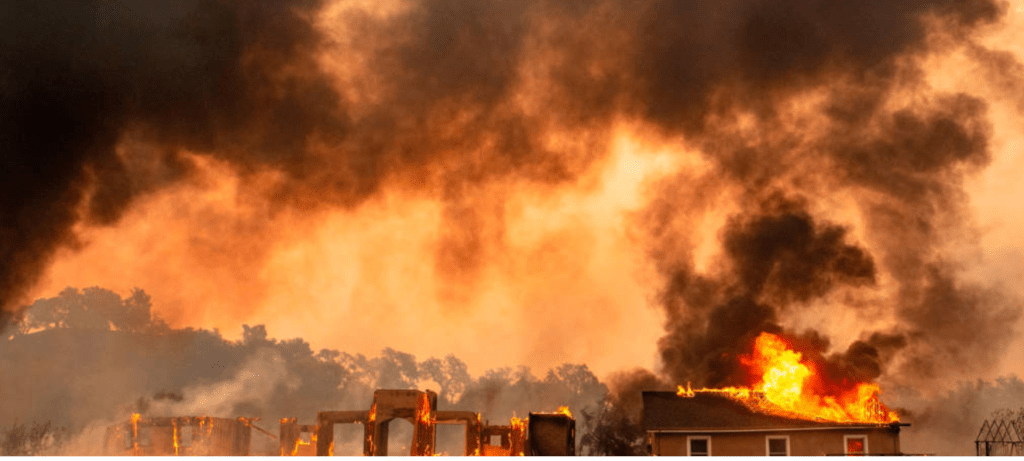
The new topography of fires–spark-driven fires traveling on winds to settle on combustible rooftops, before exploding houses like bombs, rapidly burning fires consuming dry brush underneath trees that catch fire as if from kindling, spreading across the forest floor on hillsides to ignite fires in buildings often more easily able to ignite than the dried vegetation or brush nearby, creating smoking holes as they explode in conflagrations, and unprotected “defensible space” of 100-200 meters that homeowners are asked by the National Fire Protection Association, CalFire and the Sierra Club to secure. The expansion of “wildfire-prone areas” lie at the intersection between built environment, electrical infrastructure, and dried forested lands, but create a space fires love, as even the clearing of brush, vegetation and trees eliminate natural boundaries to the fire’s embers and spread: eliminating all trees and vegetation can, according to the California Chaparral Institute. only creates a “bowling alley” that creates new paths for embers, to advance across built space, and an expansive “home ignition zone” able to generate the very devastated spaces we saw in Santa Rosa, after the Tubbs Fire, and Camp Fire, and stand to see as a new normal.

The removal of structures save their foundations in Santa Rosa suggested a bombed out landscape, reminiscent of wartime scenes. And indeed the explosive incineration of houses, buildings, and entire neighborhoods suggests something akin to a bombing campaign, provoking deeply , almost irrational searches for who was at fault in the fires’ spread, and the spread of spark-driven fires across built environments, leaping on the roofs of buildings and igniting bonfires that move quickly from structure to structure, destroying entire lots of tract housing in intense fireballs of heat.
Is Obi Kaufman’s map the true map underlying the panic at the possibility of new firestorms? Or is the map of the wilderness-urban interface a more compelling map of fires’ spread?

Both will help us take stock of the dissonance of the maps that PG&E presented of electric shut-offs, and the contorted syntax of public explication of the potential shut offs of elec. We were warned to potentially be the very wind conditions that in 2017 helped spread the North Bay Fires, rendering immediate danger signs throughout the Oakland Hills where memories of the Oakland Firestorm of 1991 were still raw, inscribed in the landscape, as the largest suburban conflagration that spread from the Oakland Hills over the weekend, as the Tunnel Fire was fanned by Diablo winds in late October,–destroying hillsides of homes, and pain, shocking residents in ways that would barely receded from the public imaginary by the time of the North Bay Fires were fanned a quarter of a century letter.
The turn to shut-ffs as a way of constraining the threat of fire, and the spread that winds pose to the energy infrastructure of Northern California is ridiculously improvised, and results from the lack of public involvement in the provision of what is overseen by a for-profit corporation, responsive to its investors: but can better maps of regional drying and apprehension of the cascading crises created by global warming and climate change we better collective response to fire risk?
The smooth abstraction of regions of greatest risk for smoke alone is removed from this landscape. But it reveals the extensively broad public health consequences of problems of fires in Northern California–problems that cannot be pinned on one agency, dysfunctional as that agency might be given the nature with which the ground is changing under its feet that cannot be understood in terms of profits, stocks, investment potential, and dividends of dollars and cents.
The question of local risk and regional risk has not only begun to outstrip cartographical abilities as a result–
–but may have grown beyond the abilities of cartographic palettes and data visualization tools, as they suggest the unbalanced nature of such extreme climate disequilibria.
While this map is only one map of smoke risk from the Camp Fire, it suggests the degree to which the nation’s health is tired to California’s heightened fire risk–

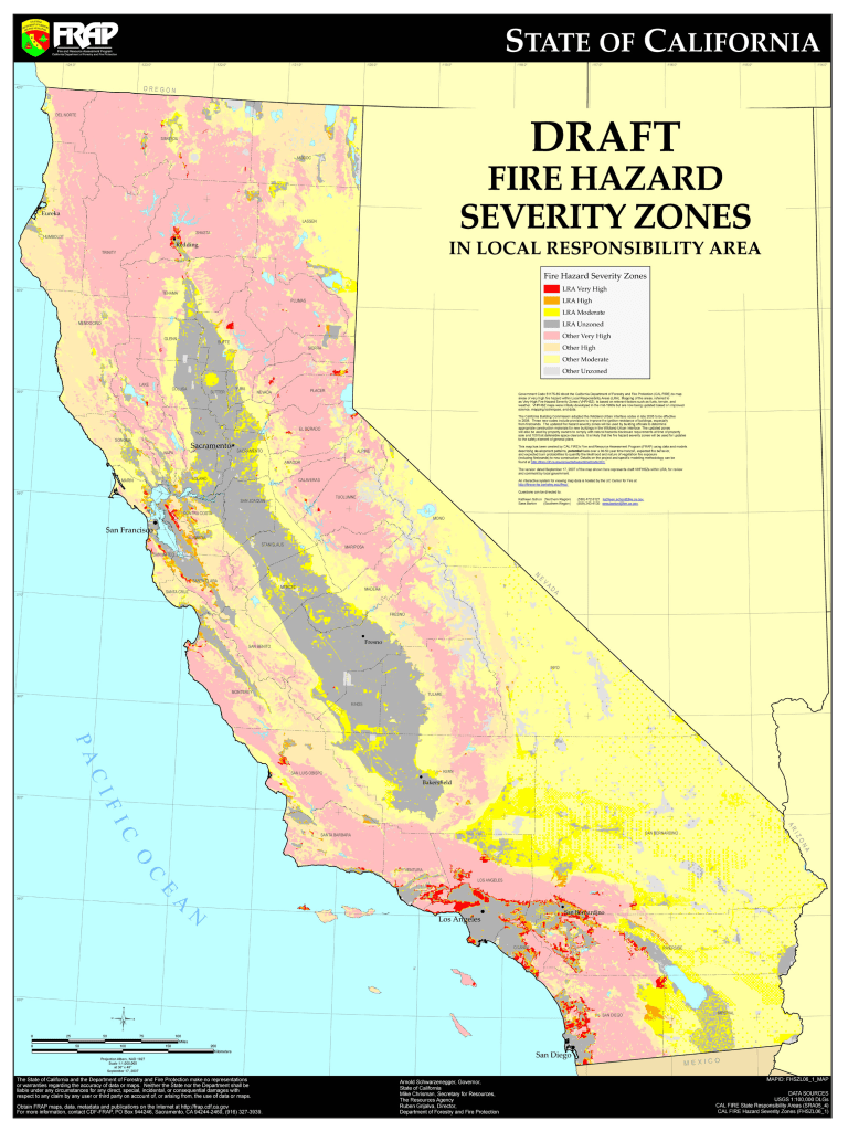
–the images of Fire Risk in Northern California are too often drawn in overly static terms of “hazard severity zones,” as if to use static overlays to suggest risk, and–for in the finer print lies the devil in this 2007 map–those for which the state was deemed responsible, as if the state is not responsible for the well-being of all.

The problem of local management of fires, which covers most of the state, is poised to become an inferno of displaced responsibility,
And while we think of this as restricted to rural woodlands, the fact is that, in a scene worth of Ursula LeGuinn, the risk of fires is increasingly approaching urban areas, in which we remain drastically unprepared.

