
The mosaic of the regions that were consumed by fire in the past five years in California reveals something of a patchwork quilt. But the dramatic expanse of the Camp Fire that consumed the city of Paradise, CA suggested a new era of fire regimes,–as it flattened the city in ten minutes, creating refugees of climate change on our own soil as it destroyed 14,000 family dwellings and displacing 50,000, with refugees across Yuba City, Chico, Sacramento, and across Butte County.
Nearby, the devastating fire was witnessed differently than other wildfires: as the air entered our lungs in the Berkeley, Davis, and Sacramento, and we witnessed the sun go red and skies grey. While the fire was removed, it was immediate, inhabiting multiple spaces at once, if burning across a wooded landscape and consuming huge carbon reserves. While a recently elected Chief Executive suggested that poor care for the forests–and failure to open forests for logging–had in fact elevated the nature of risk, the new ground plan and indeed acceptance of increased risk was not tied to forestry practices ate all. The problem of responsibility orblame was never shouldered, or addressed, but the question of reconciling the expanded electronic infrastructure and the on the ground situation of a pronouned lack of water, limited culture of corporate responsibility, and unadresed infrastructrual improvement led more fingers to point tot he power company, perhaps out of frustration at having the events that boded huge healthrisks too be taken from out’s hands. The examination of fires’ outbreaks beside electrical infrastructure is haunting–
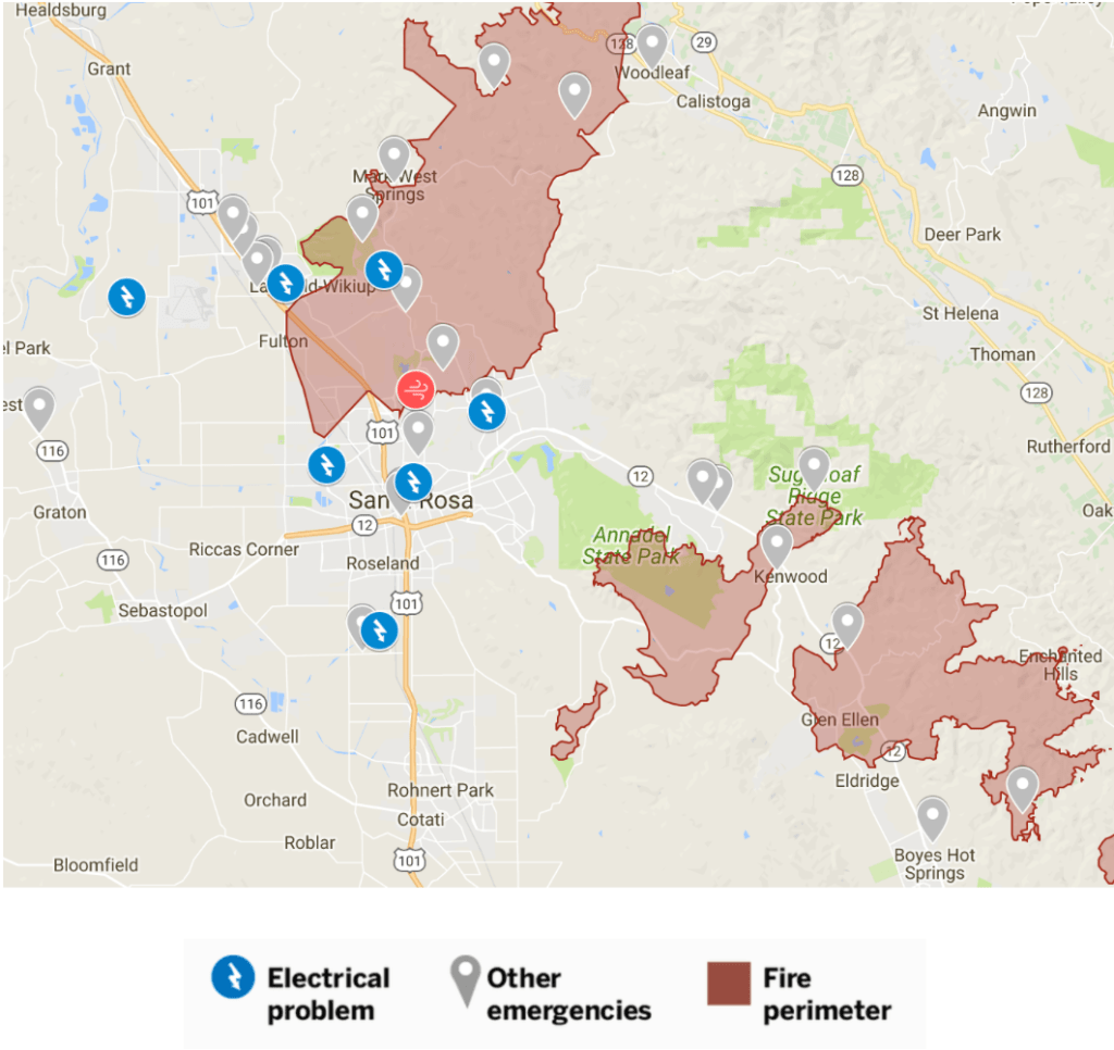
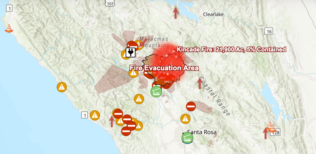
–as is the reporting of electrical failures that map onto the ignition points of fires cast as “wild” from the Camp Fire to the recent the Kincade fire, which has rapidly grown from 16,000 acres to consume 76,000 acres in Sonoma County and rapidly destroyed unknown numbers of homes. And as maps of evaluation zones and electrical shut-off zones proliferate in the face of the recent fires across Sonoma County, they suggest the arrival of a new normal has reconfigured a beautiful open space. Is this a map of ensuring safety, or of covering liabilities?
The focus of immediate responses only allow risk of climate to residents is only set to expand.
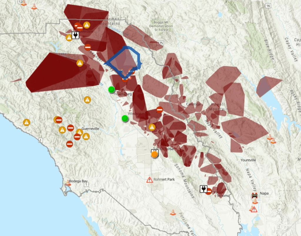
While the maps of electrical problems on transmission lines, transmission lines, and ignition sites are terrifyingly removed from questions of global warming or climate change–or climate preparedness–the very questions of Despite a surfeit of passively sensed information of mapping fire peripheries, we have little sense of the tallying of such data on atmospheric or ground soil dryness, their impact on brush, or even the expansion of risk across the drying out landscapes of northern California. And so, we turn to transmiussion lines, leading PG&E to adopt strategies of electric shut-offs to restrict the flow of power, rather than to recalibrate fire risk.
KQED
When, this fall, at the start of Fire Season, NWS warned about this danger of fire, which couldn’t have been clearer in anyone’s mind. PG&E’s new board of directors wereforced to select a plan of action with the growth of Red Flag warnings across the northern state.

If the dystopia of Fire Season lay last year in raging firestorms that consumed homes, tract housing, and high carbon forests, the safety measures that were adopted after the North Bay Fires of 2017 to curtail corporate responsibility have become a new dystopia, of intermittent power supply, immediately inconveniencing the poor, elderly, and infirm, as a temporary safety tactic was extended to thirty-four of fifty-eight counties–over half–as if this was a new strategy of fire prevention or containment.
For Califorrnia’s largest publically traded utility, Pacific Gas & Electric, faces charges it is unable to maintain, respond, or oversee a state-wide safety issues beyond its control, even if it has entered bankruptcy. The state utility company has been widely blamed for failing to maintain the safety of its transformers has just openly recognized its transformers were the “point of ignition” of the recent tragic fires–exposing itself to 11.5 billion in damages for what was the most deadly fire in California history as it spread across 150,00 acres that the admission of a site of ignition and previous charges for which its equipment was blamed, if not $30 billion in damages.

