
We can only affirm the true needs to re-imagine energy infrastructure on microgrids. The inappropriate strategy of fire containment adopted by PG&E after the company acquired privileges to declare power shut-offs that didn’t seem “surgical” at all. Even if Bay Area State Senator Jerry Hill chastised the corporation that all safety shut-offs “must be a surgical, last resort measure,” not a method of containment, leading PG&E to assure customers “this is not a step taken lightly” in the face of alarmist red flag warnings as high winds placed locations at high elevations in particular danger as the National Weather Service predicted high winds. But it may be that we have to acknowledge that we live in a state of siege, where such staged black-outs have not only lost the state billions of dollars, but created their own streams of climate refugees, as Sonoma fires create refugee streams of their own of nearly two hundred thousand.
The vast swaths of land covered by these recent “red flag warnings” led to shut-offs that themselves cost the state’s economy billions of dollars, as the extensiveness of PG&E above-ground grids, a year after the energy corporation was judged liable for multiple fires determined to be sparked by the power lines that they operate, extending across hundreds of thousands of miles, that were judged to be insufficiently upgraded and indeed extended into the “Wildland-Urban Interface” of high tree density.


The opportunity of the shutoffs created broad review of the transmission lines to by multiple helicopters, where they had already found, between October 9-11, over one hundred and twenty cases of power line damages.
Were tmaps of actual shut-offs more a technological dream, adopting the oldest trick in the book of shutting off power to prevent a melt-down in the guise of “Public Safety Power Shutoffs” across thirty counties? The consequences of affecting over 250,000 in the Bay Area (shown below) and millions across the state in response to news of high winds weren’t thought out much, if PG&E protested that it didn’t take the step lightly. It was forced to, however, by the fear of new scales of its own liabilities, and the need to forestall the eventuality of flames. While not triggered by climate change, the glowing turquoise almost radioactive snaking overlays fake technological expertise of controlling a man-made problem, and suggest just how broad the dangers of fires has become in the state.

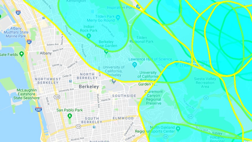
Although what a “surgical” sort of shut-off of electricity would even be was immediately unclear–especially given the extent of the over 81,000 miles of overhead electric wires the create a patchwork across the entire state, and define the transportation of current in all the areas within the red flag warning shown below. Protection would presuppose assessment of transmission poles, the clearing of nearby trees, and accurate tools for pinpointing the velocity and directionality of high winds.
Risk is rising across this landscape in ways off the chart. “High Fire Danger” is, as a result, everywhere around the Bay Area, and all too broadly generalized for electric shut-offs to be able to be pinpointed with any precision. The broad red area is all WUI–“Wildland-Urban Interface”–or the edges of built space, the less well-regulated area of recent residences where building construction has boomed, fire-risk has grown and red flag warnings arrive more readily, and real estate costs and hosing shortages have led so many to relocate. This broad area of recent high fire danger is defined by an expanse of low-density housing presses up against wooded undeveloped lands where dead branches, high grasses, leaves, and eucalypts have provided kindling for large fires, consuming RV parks dotting exurban areas that many thought of as refuges from past lives, living “off the grid” amidst other urban refugees that have become crowded with highly flammable canisters of propane. If this is the area where two million homes are at risk of burning, it is the area where the vast bulk of the destruction of these raging fires has occurred. and half of all buildings that were lost in fires were destroyed: it is the site of the apolyptic image of California, and where the greatest risk of destruction lies in the new pyrogeography of climate change: the expansion of housing near vegetation is where fire danger is greatest in each successive red flag warning, even if the fires persist in being called “wildfires”: more buildings and property are destroyed in WUI, despite far less wildland fuel existing there.

Are we poorly oriented to the risks that are posed in these regions?]
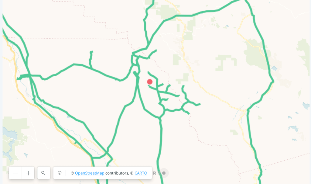
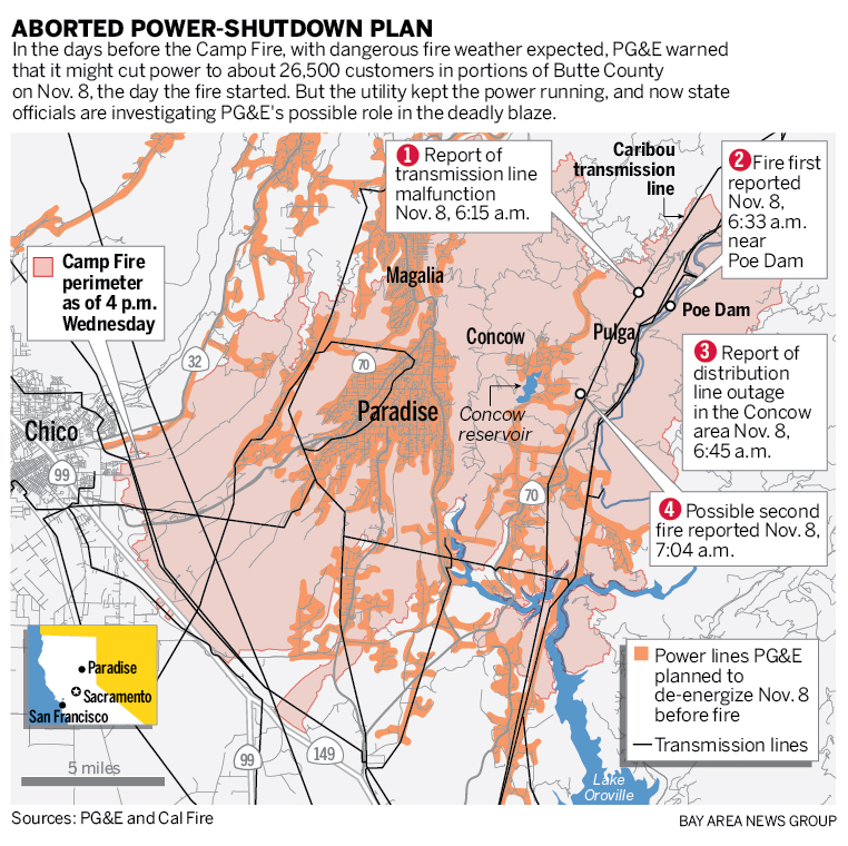
The private energy company was haunted–and rightly so–by the failure to impose outages before the Paradise Fire, even if the aborted shutdown plan almost enacted as the autumn winds began–in an attempt to foreclose the destruction of homes in Santa Rosa in 2017, once more being defended in the Kincade fire of 2019, and had led to an October blackout in the Sierra foothills in October 2018, and localized shutdowns had been planned before the Camp Fire in early November 2018, days before the outbreak of a deadly fire that burned 10,000 residences and left many without homes. KQED Public Radio mapped the Kincaid’s Fire start with open source mapping software, offering a more on-the-ground orientation to how an older transmission tower ignited these flames.
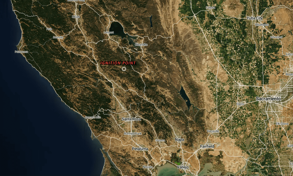
The failing of above-ground electrical systems and transmission lines have been blamed on the spread of fires in high winds across coastal and inland California, power companies planned to use such shut-offs more aggressively, haunted by the scale of potential losses, based on predicting weather and simulative models. Indeed, the aborted plans to end current flowing in transmission towers in Butte County is charged to have ignited the blaze that quickly spread to become the Camp Fire, the deadliest in California history, whose perimeter grew as it burned over 150,000 acres–the break in a connector linking incoming and outgoing power lines that were carrying 230,000-volts through a 40-year-old tower, not been included in PG&E outages this time, began the Kincade Fire as it broke as gusts of wind broke eighty mile per hour, which would fan that fire south, across another 77,000 acres—even as the shut-offs prevented more extensive destruction of the dry, forested landscape by fires.

The overlays of the fires atop a green, verdant landscape suggest that we live in an era or region of health. But it is a landscape haunted by recent destruction. But the company whose liabilities had been stretched, and whose investors had so balked at covering the costs of the fires of past fires, were haunted by the images of the destruction of whole towns in Paradise, CA and Santa Rosa, CA, whose containment costs and massive destruction of lives, property, and residences was engraved in memory.
In the East Bay and in Oakland, we’ve been looking at fire warnings in public service announcements placed on the side of park entrances and highways for over ten years. But the recent maps of fires’ destruction have helped erode our sense of place, reminding us of extreme dangers of remaining in the very places we once thought familiar, and reassuring, as if to alert us to extreme shifts of climate for which the state is in fact dramatically underprepared to process or confront in their extremity.

What is fire preparedness? Can it be suggested in a regular map? The emergency warnings that extended a red flag alert of extreme fire danger to the entire Bay Area on October 8. As the gustiness of local winds grew, fear turned to the almost overly familiar spread of fires, as an eventuality, giving grounds for the back-up strategy of power outages to curtail the chance of fires’ potential spread across overly dry brush, old growth forests, and dead grass, destroying tracts of housing, rural suburban areas, and sending toxic smoke and flakes of ash from what are misleadingly identified as “wilderness” fires into urban areas, which have been anthropogenically shaped, as areas of extreme combustibility.
And so, as we discuss the possibility of state ownership of energy industries, who are unable to be compelled to service or maintain aging power stations and transmission lines they have essentially raised up their hands in despair when tasked with the responsibility to oversee, the very harmony of the state seems increasingly uncertain. Although less square acreage has so far burned in California than in previous years, in part due to the familiarity of this new firescape and in part due to luck, there is a pronounced division of the state among the rapidly expanding “wildland-urban interface”–the intersection of uncultivated land and often uninsured or unowned residences–across which many fires begin and burn increased property, increasing insurance costs across the state, the area of risk spans a larger region than before, as rolling blackouts seemed to indicate the impossibility of investor-driven utilities administrating the state’s energy grid. If electric malfunctions in PG&E equipment ignited six out of ten recent fires in California, and was already tied by CalFire to seventeen major wildfires in California in 2017. even as intentional blackouts or “public safety power outages” sought to prevent many further fires, fires have spread across the state.

The landscape is not only increasingly incoherent. There has been a longstanding attempt that hoped to find an alignment within the private management of a power grid that provided an undying supply of energy–a tasked to Pacific Gas & Electric, even as the privately held energy corporation has shockingly been unable to assume full responsibility of the maintenance of the grid, and as the grid has been stressed by climate changes and extreme winds, of velocity of up to 100 miles per hour, that they were not ever planned to withstand: the extension of highly charged power lines along aging transmission lines and towers, that now extend into many undeveloped lands and areas of California, have created a geography of responsibility difficult to match with its combustibility.
For it extends amply over an over-extensive network of thousands of miles of transmission power lines no longer able to be sustained. An older map of the Wall Street Journal that seemed to ask readers in 2017 how the energy behemoth could responsibly manage the grid. Indeed, PG&E might not be able to maintain a network of such wide range, let alone sequester its drone data on power infrastructure that was not publicly open, or provided by the state. We were already invited us to try to map the administration of the electric grid onto a new weather system, in ways that has not been adequately done, reckoning the extensive electrical grid against state fires that have ignited 2014-17.

If the map seems only to suggest a correlation of responsibility, the burden of responsibility of numbers of fires that were sparked statewide by equipment of the energy company calls for a regional fragmenting of the behemoth of the state-wide energy grid,–if not into locally controlled “micro-grids”–to distribute the broad responsibility that the company equipment has effectively assumed liability with limited public oversight–even as the numbers of statewide fires tied to energy equipment has doubled since 2014, and now stands above five hundred per year.

Microgrids are able to be run autonomously, islands within a statewide expanse that seems overly fluid in its weather situation to be managed by one entity alone. The expansion of a system of micrograms that worked autonomously were in fact endorsed enthusiastically in 2015 by then-Governor Jerry Brown in his 2015 inaugural address, before he retired to a rural family compound, Rancho Venada, itself powered by a microgrid system. Indeed, if the “resilience” of micrograms has been long championed as a way to support local communities when power was down, the ability to manage such smaller islands of energy infrastructure, while they would demand a huge investment, could keep needed public functions in operation in outages, and offer an alternative to large power companies that could carry less charge, and provide a reliable option to revitalize the energy infrastructure in a time of crisis.
And despite the huge change in the evolution of fire-readiness of California firefighter, crisis response teams, and planning and investment for local fires, the shifting climate-challenged landscape demands a better and differently managed electric grid. We are in a challenged landscape of disaster that we don’t completely understand, despite the overmapping of the fires and their spread: as the challenged Chief Executive describes them as “forest fires” much as he has threatened to cut federal aid to the state because of his disproportionate fears of endorsing environmental regulations, attacking Governor Newsom for having done “a terrible job of forest management”–not coincidentally as his own job ratings enter free fall–as if treating him as a subordinate who he had instructed to “‘clean’ his forest floors,” as if telling his children to clean their rooms,–even though only 3% of the forests are managed by the state.
The President has hinted at refusing federal aid as a form of inter-party warfare. If his nominal reason is the disproportionate level of “burn in [comparison to] others states,” as if all states contain the similar climate conditions where fires are driven by wind, accessibility to firefighters, and similar conditions of burning. Yet California has long been and appreciating the geography of the fires is incumbent: not only is the state less rapidly accessed, but the increasingly hot dry air the Santa Ana winds, rising from the desert plateau west, bring to California, heating up as they move to the coast, have been as responsible for the increased fires as their gustiness, and fundamental foreignness of California’s distinctive challenges to federal agencies as FEMA. It may be that, as the contrarian Mike Davis argued in The Ecology of Fear, “to spend millions saving homes in areas never meant for neighborhoods and power lines is not just folly, but a waste of public resources,” as misplaced interest in managing fire ignition only invited the danger of accumulating chaparral in ways that made doomsday firescapes all but inevitable in the state. But the landscape has undeniably changed.
Activist Mike Davis critiqued “public subsidization of firebelt suburbs” for a “monomaniacal obsession with managing ignition rather than chaparral accumulation” that made “virtually inevitable” doomsday-like firestorms. Improvident planning by the state shaped California’s “Fire Coast,” he argued, and set the stage for greater coastal combustability. It is interesting that President Trump has shifted responsibility for the fires onto the state’s management of water, for having “ridiculously closed water lanes coming down from the North”–an anti-big-government argument that redirected natural resources in fact prevented firemen from extinguishing conflagrations, and a failure of “proper Forest Management.” “Billions of dollars are sent to the State of California for Forest fires that, with proper Forest Management, would never happen,” Trump wrote on social media, explaining how he had “ordered FEMA to send no more money” to the state–treating the federal agency as a means to stage a war against the state governor. What Trump called “a disgraceful situation in lives & money!” reveals an impatience removed from land management and environmental re-engineering. If Mike Davis felt “Paradise” was ruined by an unrelenting drive to “speculative subdivision” by real estate marketers, Trump seeks only to remove the growing and fiercer wildfire season from climate change.
In preaching deregulation, Trump shows poor executive skills in failing to appreciate the complex ecosystem cycle fires long created in California, and the benefits of fires, but is also deeply ignorant of how the early 2018 map by which state regulators work to respond to the destructive fires in 2017 reveal a geography of risk unable to be localized in the state–or the pervasive threat of fires in a state where forests have dried out over time, and forests continue to remain especially vulnerable to multi-year drought, even after one “drought” has officially ended, given the sustained lack of precipitation during the summer months, and the broad depletion of subsurface storage of water across the state, and the limited resilience of forests to drought that results from low subsurface water storage created by low precipitation over multiple years.

Even the one-color reducetion of the data vis that CalFire issued in early 2019, to anticipate this year’s fire season, pinpointed a wide distribution of fire risks across the state–bound to generate alerts of greater risk with the rise of winds of eighty up to a hundred miles per hour–that reduce a recommendation for sweeping forest floors (like in Finland, Trump suggested in 2018!) placed over 350,000 Californians in cities and towns that lie in “very high fire hazard severity zones” and 2.7 million Californians in the high severity zones in toto, using Census records, and some two million homes at risk. Threatening to cut federal aid in attacks on Democratic leadership suggests a failure of executive performance akin to Trump’s notorious suspension of aid to Ukraine until it provide “dirt” on Joe and Hunter Biden for the alt right news media to diffuse–rather than the increasing dangers of where California fires may spread.


