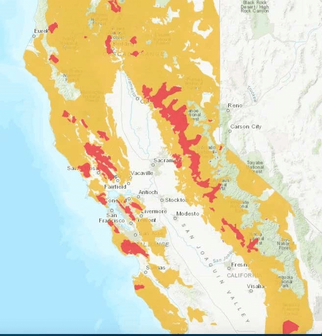
The range of fire intensity can be mapped synchronically to paint a picture of the intensity of tree loss and fire spread in most all areas of the state outside the heavily irrigated Central Valley. Fire, in Obi Kaufman’s powerful rendering, seems the destiny of the state that its inhabitants have denied–but the anthropogenic character of increased fire intensity is only being clearly confronted for agencies like PG&E that have responded to demand by building out electric infrastructure in areas of already high fire risk–a build-out they can only respond to by subtracting electricity at the drop of a match.
And yet we are compelled to map the increasingly combustible landscape, and map it repeatedly as if in the hopes to press out meaning from the landscape in hopes to make meaning out of something that is both a local, regional, and global phenomenon, as if to press significance out of it that we can better grasp. For so much lies on it. If California is something of an improbable test case for global warming–an advanced economy that lies at the cutting edge of climate change, with the most cutting edge and intensive mapping abilities at its service, there seems to be some way to serve its communities better. And in a region that relies intensely on maps, for commuting, watching weather predictions, and navigating real estate and home buying as well as school districts, parks, and criminality with increased intensity, where better but to expect better mapping of climate change?
If the report card is not good, it is because the picture is so dire, and the maps so poorly correspond to clear-headed choices or expectations. Indeed, they only multiply the parameters of danger the state is courting as it enters a climate emergency of droughts, fires, desiccation, and sea-level rise, of which fire risk is only the most prominent.
The recent plague of fires since 1995 across the state pose a question that we never expected: have the extremes of climate change forced us to return to geographical constructs of a lost past? If so, it is mediated by the nature of real estate markets in late capitalism in an overcrowded state: for the expansion of building not following regulations or preventive measures of fire safety has shaped the changing contours of risk in ways that we have been able to map most recently by the proxy measure of transmission lines across the state whose collapse has resulted in so many recent ignitions. Fires of increased burn-intensity, rapid and aggressive spread released carbon emissions in the 2018 fire season collectively totaling emissions of a year of power in the state–sixty eight million tons of carbon dioxide, as well as untold property damages and loss of lives.
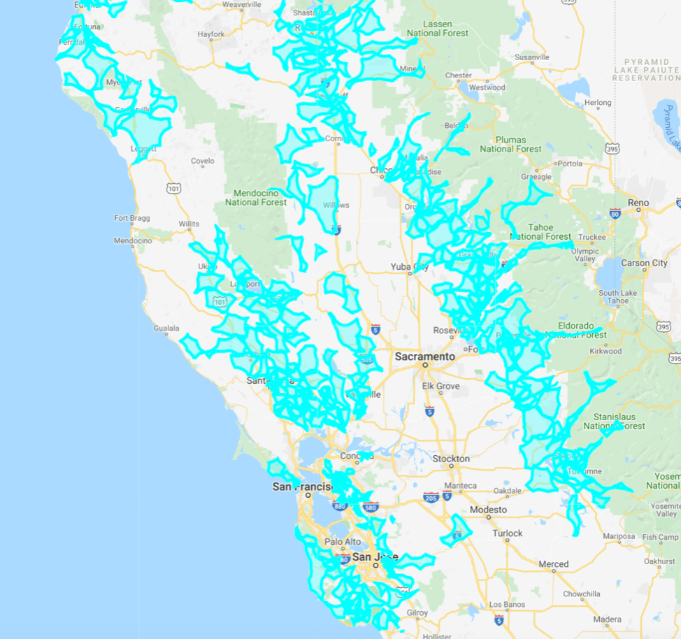
This terrifying vision of the losses that fires bring has not only haunted the nation but created a corporate restructuring of Pacific Gas & Electric, the privately held power company. For the fears of past fire continue to haunt corporate policy. And if the power shut-offs that cut off electric power to provide the company time to inspect all power lines in the region seem, as the mayor of Malibu, Rick Mullen, put it, an eighteenth century technology to respond to a twentieth century problem of global warming, the mapping of shut-offs seems to have been invested with the appearance of high-tech tools, even if they were low tech approximations of where transmission lines ran–of limited actual data.
The frustratingly low informational level of these maps, which seemed to promise so much in an era of high mapping of fire spread, intensity, and directions, responded to gustiness more than fires, but imagined the threat of fires that seem only destined to grow in the feedback-loop of climate change and global drying that afflicts the state. The vivid aqua of recent outage maps snake across the landscape that reflect not only the imprint in their iridescent glow, but fail to educate consumers by keys that might adequately orient them to the imminent topography of combustibility, or the dangers of fires but only trace the negative spaces where power was at risk of being suspended across the state–roughly following the above-ground power lines that run across the woodlands-urban interface, telling us what those of us who have been looking at fire maps over the previous three years already know, and maddening most by raising the prospects of suddenly losing electricity, cel service, radio contact, and perhaps even the ability to charge their cars.
The maps might be confused with a form of readiness.
They seemed a rather desperate attempt to escape similar levels of financial liability to find a shred of liability release and summon a sense of corporate responsibility by suggesting that they prioritized public safety in an era when public safety is in crisis mode.
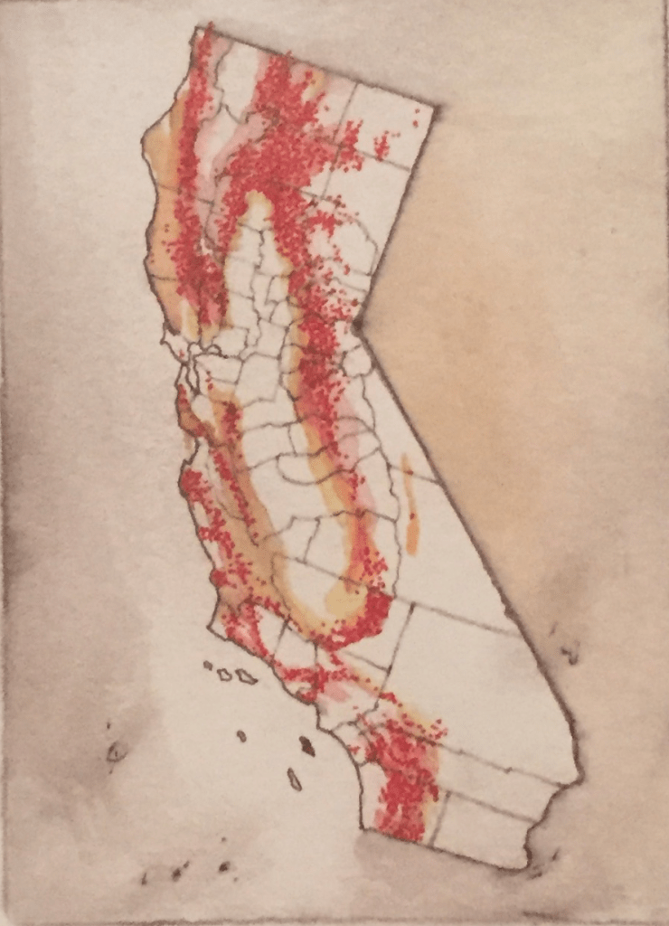
Of course, PG&E is in crisis mode–and the maps reflect their difficulties in shouldering the possibility of liability for future fire outbreaks. Faced by bankruptcy, and apparently conceiving itself without funds to trim trees or prioritize the maintenance of transmission lines, the power behemoth has resisted spinning out parts of its extended enterprise, but rather insisted on its continued profitability, without, apparently, acknowledging the risks that the continuation of extreme weather in the state might cause. The resulting maps of shut-offs that were reflexively announced at the first word of high gustiness-surprising many consumers, created skeletal images of the forced closure of electricity to hillside towns, ravines and moutainsides in once bucolic areas, where property is sold in hopes to perpetuate the vision of bucolic hillside towns, which now looked like sculptures of Walter De Maria’s Lightning Field, as if natural sites of aggression, or jagged lines ripping across a natural landscape,–

–if not, more situationally appropriately, as this image by the Otolith Group from a film that reflects the seismically disruptive landscape of California, the creation of the anthropocentric environments that we have created in what was once prized as a landscape of pristine nature, as if this existed, but is now increasing at growing risk of being scarred as a man-made landscape is electrified.
For the maps of forced electrical shutoffs are truly creations an anthropogenic environment, if they are supposed to respond to wildfire risk. They reflect a new fear of the management of landscape, and of electrical infrastructure, based on the spaces served by the infrasctures of electrical power transmission lines, and the regions that they affect.

Rooted in the current growth of urban interface, the topography of landcover where older electric infrastructure bears new loads of coursing current provides the chance for transmission lines to create ignition points for fires, in the stripped-down maps that provided the basis for the outage maps PG&E posted in the Fire Season of 2019, haunted by the memories of the burnt landscapes of the 2018 fires.
Even as the Department of Interior of the Trump administration blamed poor forest management, the location of fires suggest that “proper forest management” was less a problem than the poor oversight of the expansion of realtor’s rapid remapping of extra-urban additions across the state–in the very regions where residents were effectively warned by the energy company itself that it would adopt new policies of cutting electric power that took full advantage of emergency powers it was granted as it entered bankruptcy, announced at a dedicated website it unveiled, www.PrepareForPowerDown.com, in order to reduce its liabilities, even if it only announced it only introduced “Public Safety Power Shutoffs” in order to “keep communities safe” in the eventuality the state continued to face extreme weather in the future.
If this is a landscape of late capitalism, and the burgeoning real estate market, the maps of outages are echoes of the far deeper, pressing questions of the landscapes of risk we have often forgotten to map with needed accuracy–even if we fear the destruction of the very extra-urban additions that have been broadcast to the nation as if they were the bombed out battle sights of global warming, and we have yet to map in the parameters of a climate emergency or bureaucratic irresponsibility.
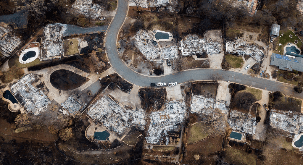
While the map was not about to receive much circulation even as PG&E representatives visited California cities to inform communities on the urban interface for the eventuality of a power shut-off of “public safety,” the image by which most of the state was haunted by drone imagery from the previous fall was of the burnt-out areas of Paradise, CA and of Santa Rosa, from previous years, that so surreally seem to transpose what are bombed out areas of war fields and American suburbia with an almost hallucinogenic quality that bodes fears for the future of California–and, after this map appeared from the California Public Utilities Commission, haunted PG&E enough to provide a basis or template for warned outages.
Even as the energy company promised investments to “make its grid sturdier,” it predicted the likelihood of executing shut-offs “multiple times” in the future, as it indeed had in the Napa Valley Fires of 2018, but which it had not in the 2017 North Bay Fires which had caused $14.5 billion in property damages or the 2018 fires that had raged across an unprecedented 1.9 million acres–a surreally tipping point of sorts, transcending poet Walt Whitman’s query of readers’ ability to reckon a thousand acres by a multiple of thousands–and exceeded 16.5 billion in property damages in the Camp Fire alone, which PG&E is still trying to accommodate victims for property loss, wrongful death, or loss of residences. If the ongoing deep-lying effects of an officially over drought have conspired to create a shortage of underground reserves in the entire state, compromising the state of its forests and undeveloped areas in ways that go far beyond “forest maintenance,” it has created a lopsided continental map of fire risk whose consequences will be felt for decades.
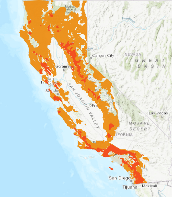
The ever-increasing uncertainty of the landscape multiplied in unknown ways with the spread of power shut-offs whose enactment appeared a straw that broke a collective back: if the threat of smoke had created panicked uncertainty across the Bay Area in previous fires led residents to shift from the color-coded *AirNow” EPA maps of air quality–3.2 million in a week, causing the site to crash–during the Camp Fire, and rushed to interactive open source alternatives for greater security, the insecurity of announced electrical shut-offs seemed to make the state all the more inhabitable, and suggest that the relation of habitable and inhabitable lands was being rewritten by climate change with unforeseen rapidity, as the maps from the California Public Utilities Commission that provided the basis for PG&E to warn of electrical shut-offs registered, based on the expansion of areas of urban interface in Northern California on both sides of the San Joaquin Valley, an area not serviced by PG&E.