
The combustibility of California is not anything new, and has long haunted the state. Mike Davis examined with greater care than many earlier geographers the ntersection of the “wild” and the developed lands. He suggested that the transformation of California was not recent, but began with theextension of the Pacific Coast Highway beyond Los Angeles in the late 1920s changed the topography of fire in Southern California by introducing “a potent new source of ignition–the automobile–into the inflammable landscape,” creating the first firestorms in the Pacific Palisades that gave rise among Angelenos that “our whole city might go.” The fears and the geography, Davis suggests, to have inspired Nathanael West to imagine the burning of Los Angeles in The Day of the Locust.
West had, in the late 1920s, imagined his hero Tod Hackett as an arriviste painter in Los Angeles who faces the landscape with skills gained at Yale Art School; Tod becomes a prophet as he paints the vivid prospectives offered in a “canvas of Los Angeles on fire,” a fire he imagines as itself enacted by Angelenos so “desperate enough to set a single city on fire, let alone a whole country.” The set designer who works on soundstages in Hollywood drew from art history training back East to devise grotesque images of a fear urban fire’s effects drawing on “Goya and Daumier but also of certain Italian artists of the seventeenth and eighteenth centuries, of Salvator Rosa, Francesco Guardi and Monsu Desiderio, the painters of Decay and Mystery“–an image so terrifying, if never depicted, to become embedded in the dark history of California’s own geographic memory.

Farhad Manjoo indeed evokes a similar image of planned disaster that presages the “end of California” in his recent column, and is perhaps so powerful a pronouncement to become a much-discussed meme in social media. As West, Manjoo’s tone is apocolaptic. The popular reflexive reaction to Manjoo’s column may well reveal the place West still retains in our national spatial imaginary. It is even more eery that West’s novel demands to be itself seen, if pure fiction, as written as a commentary on the Decker Canyon fires that so eerily burned during the Woolsey Fire of 2018 again, scorching over a hundred and fifty miles along Decker Road and Malibu, as they had spread across the Santa Monica mountains in the 1920s or 1931–in the years West wrote–and continued to spread across mountains patches during and after World War II, with far greater mortality risks, until, most famously, in 1959, when Malibu was transformed into a “national emergency” in the Eisenhower age. Did the transformation in the region’s ecological management to reduce risks of wildfire safety themselves help transform, as Mike Davis argues, the hundred acres of chaparral to the “Fire Coast”?


The region’s increased residential settlement surely did. The influences of the man-made anthropogenic influences on the recent fires that have so changed the landscape were undoubtedly also the result of them. “Fuel, not ignitions, causes fire,” observed geographer Richard Minnich, who has long studied the fire ecology of California vegetation, landscape, and brush, if his arguments are contentious and questioned. The broad ecosystemic change of wildness-urban interface areas have created not only new policies of land management that Minnich has disdained, but transmogrified transition zones for “edge species” among biological communities, and a new geography of fire spread and firestorms, increasing both the combustibility of the landscape and its appearance.
There are many reasons for the combustibility of Northern California landscape that drought has magnified, as it has created an analogous but quite specific landscape of fire risk, that cannot be seen as either entirely anthropogenic or entirely wild, but reveals the blurred nature of the wild or natural and the human in the age of the anthropocene. For the increased settlement of the region of Northern California has combined with climate change and global warming to produce a landscape of extremes. We can indicate the combustibility of the landscape not only in housing that is poorly maintained for fire safety, but the increased combustibility accelerated by an arid landscape, in ways that have sent many alarms in the biological community, and have magnified fire risk in the north in ways not limited to the poor management of brush, defensive space around houses, and extra-urban settlement: the new nature of the “wild” has seen the death of oaks across many hot-spots of fire risk, where Sudden Oak Death has become rampant in recent years, in ways we don’t understand: dead oaks elevate risks for fires’ intensity across the North Bay, providing fuel that is all but waiting to combust, and the growth of tree mortality that has recurred in recent years after rains renders even more dead live oak trees in the extra-urban landscape, rarely removed, as pathogens not fully understood have entered the landscape that have heightened its increased vulnerability to firestorms.
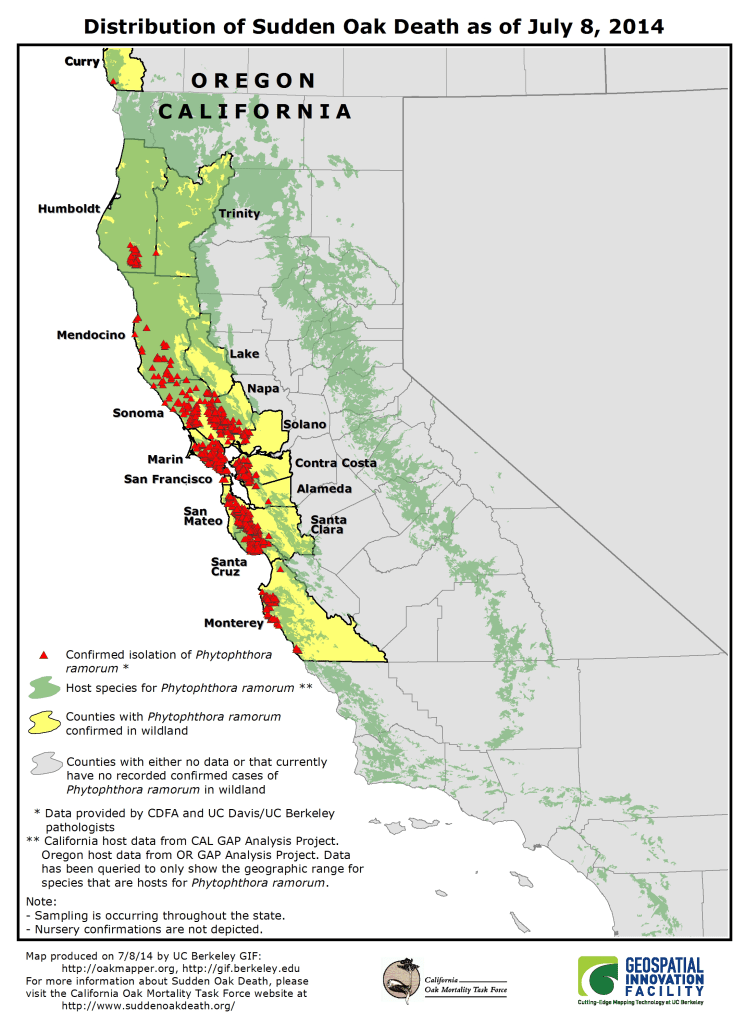
–as over a third of the live oaks in the area of the North Bay fires in wine country were found to be bearing pathogens of Sudden Oak Death.

Northern California remains haunted by these firs. And as haze and burnt acrid air settles over San Francisco and blanket the Bay Area, fire season has begun again in Northern California, but that the landscape where it unfolds is indeed new. The densely populated Bay Area is surrounded by levels of particulate matter from the fires based in the Sierra Nevada, sending some flakes to San Francisco, as alerts are issued to those in Santa Rosa, Livermore and San Jose sensitive to air quality to avoid extended outdoor activities, and reduce time out of doors. The spatial imaginary of northern California is, like its landscape, is so scarred by increasingly destructive and powerful fires, threatening its historic landscape, compromising our sense of place in apparently definitive terms, strangulated by the extended electric grids that PG&E has rather blithely if irresponsibly accepted its task to service, even as it refuses local attempts to purchase or break up the energy company as against the interests” of customers.
What seem quite hastily concocted shutoff maps of alarmingly low information levels are, in a sense, emblematic of the deep disservice of poorly managing public utilities in a for-profit manner dictated by costs and financial return: to operate power equipment across dry terrain in such a manner cannot but conceal questions of liability, best practices, and the importance of wildfire regulations, but suggest a disturbing inability to map responsibility for energy systems that have been constructed across the state. For the lack of orientation to deeper problems of forest management and public safety that go beyond the failure of imagination Farad Manjoo concocts from inflexible pressures of low property taxes, poor managment, and pervasive corporate greed. Rather than map a coming storm as endemic to the state. Indeed, the problems of low fire insurance, easy access for home construction, and poor enforcement of corporate responsibility to map the challenges climate change place on local shoulders.
The problems of mapping responsibility for fire prevention and suppression is changing, and has evolved, but one would not know this from the sudden power outages–or the maps that PG&E issued to its disoriented customers, alerting them of the danger of power shut-offs that seem generalizable across the state, given increasingly warm winds from the Great Basin, that have entered the peaks of the coastal mountain ranges in California at up to a hundred miles per hour and define the “fire season” in the low-moisture state for the past eight years, pushing away coastal fog as they enter and pour through mountain canyons that are traced in the map of power outages.
The congestion of possible shutoffs in the “Wildland-Urban Interface” on the edges of parks suggested the fears of routing high voltage into power transmission lines that fed a number of outlying urban areas, often of greater affordability than cities, that has created a shifting boundaries of areas of development or density of housing to merit reclassification to or from State Responsibility Areas–“SRA land” that demands local compliance with fire codes and where state-mandated evacuations occur–that mirror many of the regions where ‘protective shut-offs’ can occur.

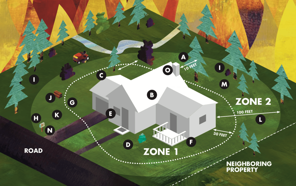
State Responsibility Areas mandate fire-safe tree thinning, landscaping, and inclusion of fire-resistant plants, an ignition-resistant roof, overhanging branches, elimination of brush near the house, and screening vents and chimneys, to protect houses from becoming furnaces able to retain heat, combust, and spread fire as in many of the ember-driven fires within the Wildland-Urban Inferface in previous Octobers.
Rather than such practices of local management, the use of random shut-offs of electricity as a preventive response to fires’ spread suggests the inability to confront the insecurity of increased fire dangers, and fire risk, and the centrality of that risk to the landscape of Northern California. If the climate crisis results from an absence of atmospheric moisture, record-setting levels of low precipitation, and high, warning winds that endanger the often aging electric infrastructure existing above ground in the growing, and the unsupportable density of an insufficiently mapped, urban-wilderness interface–an area where more and more people live, on the margins of cities, and where current seems to course closer to dried out brush, forests, and grasses than was ever intended–the shutoffs seems to reveal a need to come to terms with fire danger at the intersection of atmospheric aridity and electrical connectivity.
For the introduction of unannounced intentional power shut-offs– “black outs”–suggests how much we live on the brink in an age of uncertainty about climate change. In an age when costs of fighting fires are poised to escalate dramatically–and the Canadian government estimate a doubling of fire prevention costs in the first forty years of the new millennium–the U.S. Forest Service has silently doubled discretionary funding for firefighting in the last five years. Costs of fire suppression skyrocketed in western states, in the last eight years, in Idaho, Alaska, Oregon, as well as California, with no coherent strategy in sight. Wildfires have spread around northern California in dramatically expanded “fire seasons” have suggested a state of siege we have never seen since “slash fires” of the early twentieth century, ignited by electric sparks from railroads that hit piles of slashed down branches from once-dense midwestern forests, in a series of firestorms that erased several cities from the map.
We are have experienced increasingly elevated fire risk leaving many haunted by fears of flattening cities now proximate to extreme fire risk.

Can such extreme fire risks even be hoped to be managed by improvised shut-offs of electricity? Or do they only suggest the dis functionality of the continued provision of power to areas of dead forests, dried out grasses, and parched land, as if we did not already know the combustible nature of such terrain? If maps create spatial continuity, are we able to imagine the connectivity of an electric infrastructure in terms of above ground power lines? The investment of responsibility in a for-profit energy company has severed such questions from the maintenance of an electric infrastructure, and introduced the prospect of “public safety shut-offs” that stand to be only a band-aid to prevent corporate liabilities. The prospect of stripping energy from millions in response to deadly wildfire fears is not only unprecedented, but a misguided use of “public safety” as a priority of an energy corporation that has not prioritized safety over profit, to be sure. They remind us in a somewhat illusory way that we are able to control the fires’ spread, or manage the heightened danger of fallen electrical wires, in ways that PG&E was slow to recognize.

