
Despite the complexity of expertise required to explain the fires’ spread and indeed the problems of forest management, the maps that PG&E issued to explain outages were not clear. Only earlier this year, Judge William Alsup called the PG&E “the single most culpable entity in the mix” within the current “crisis that California faces on these wildfires.” This led several attorneys had sued the company for the huge damages of the Camp and North Bay wildfires eagerly listened, happy that some accountability did seem to be in the air. But as PG&E had let its budget for reducing trees near transmission lines whither, they seemed to illustrate utter irresponsibility in neglecting “a large number of trees that should have been removed, and that appears to be the single biggest factor in the 20107 and 2018 fires,” demanding that the fire mitigation plan of the energy corporation follow state law by trimming trees that might contact power lines in high Fire Season winds, which were only expected to grow, and placing there corporation on probation. The limited sensitivity of CEO Bill Johnson to the question of trimming may have not been able to be dislodged from how his salary was being pegged to safety performance, as much as responsible maintenance.
Judge Alsup had ominously warned the corporation it would be bad in the docket come December, wen the number of wildfires PG&E started would be reckoned, and he hoped it would be none: the expectation were balanced by the significant bonuses Johnson would gain if he created conditions to allow the stock of the utility company bounce back to the heights they enjoyed in 2017. And the power of PG&E to shut power of temporarily to 500,000 and ten 800,000 Californians provoker indignation but were won as a right to announce “public safety power shut off” with little warning was won, without being imagined to be used in such an aggressive and proactive fashion as Johnson and his Board seem to have done, raising questions about the current corporate culture of PG&E, if it had committed to “only consider proactively turning off power when the benefits of de-energization outweigh potential public safety risks.” These benefits were not only regarding safety, but the dangers of being found negligent in managing the energy infrastructure.
The problems of fire management that this mapping of fires revealed was both problematic, and difficult to respond to: PG&E asked–or demanded?–the ability to shut off power in high-velocity winds in response. The consequences were not only personal inconveniences. They may well have compromised valuable cancer research on temperature-controlled cultures within a week of conclusion, costing 500K and countless hours of lab work, as controlled experiment were rushed to San Francisco. Even if a warning on October 9 let folks know that the private energy agency “continues to warn of a power outage,” the absence of anything like expectations of such a shut-off or even plans to deal with the web traffic that meant that the “inconsistent” and at time “incorrect” information on the PG&E website, which would continually crash due to high volume of folks seeking information urgently, led to a broad swath of apologies that however refused to admit any underlying fault–“I do apologize for the hardship this has caused but I think we made the right call on safety,” said CEO Johnson, who arrived at PG&E only recently from the Tennessee Valley Authority, and installed a new Board: Johnson is a proud long-time Grateful Dead fan, but may be more conscious his salary was tied to safety performance than California topography or corporate ethics, and expected that the state would rapidly accept a declaration of fire emergency.
Perhaps the arrival of winds didn’t inaugurate a “fire season,” however, but revealed a new aspect of the electrical infrastructure about which no clear working process had been devised or imagined. If such winds inaugurated the “fire season” in California, this was now not an issue to be addressed by thinning forests or environmental management alone–the large carbon loads of forests had gained an increased vulnerability to high-charge electric sparks, in ways that had exponentially expanded the vulnerability of the landscape to fire, and risk of firestorms,–

–of the very sort that had generated ever more terrifying images around the time of the Camp Fire of statewide fire risk; winds that created conditions for the fire fanned the flames further, at higher velocities, to create firestorms and new management challenge of fire whirls, or vortices of flames of extreme heat intensity.
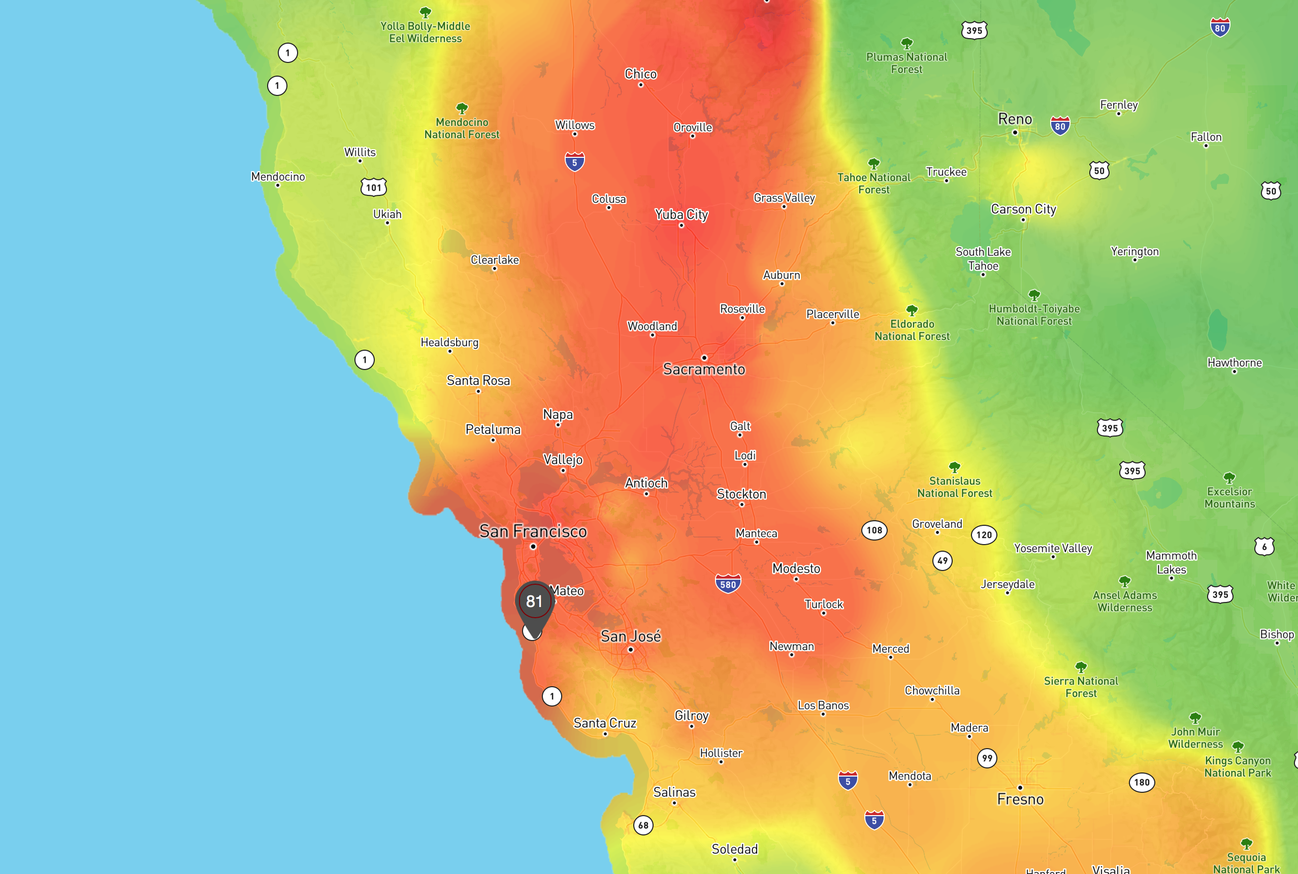
Did it all start with dry winds, or with carbon loads, or with live electric lines suspended in what were revealed to be dangerously unstable ways? Heat maps of the nature of air quality became seared into northern California residents’ minds.
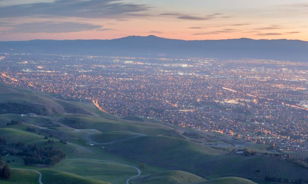
The high gusts running through trees that received far less water or snowpack than in previous years, the deep worries both among PG&E administrators who balanced their abilities of oversight of the electrical infrastructure with their public responsibility, was mirrored in the haunted nature of the Northern California residents who had seen increasing numbers of fire men stream into the areas near Chico, Sacramento, and the North Bay or the Sierras and Yosemite each Fire Season like clockwork in previous years–in ways oddly dissonant with bucolic green surroundings.

This time round, the temperature anomaly alone had offered some guide to prediction of the eventuality of future fires, but provided little guideposts to the possibility of managing the situation at hand. The arrival of winds were terrifying, and not only to PG&E. The gustiness of local winds seem new indices that will mediate all future responses to what Daniel Swain called the ongoing firestorm of California, and are destined to filter our future collective reactions to future fires’ spread. But is thE ermetgernce of a new preventative imposition of power outages even a sensible response, or grim, for an area of the nation where a huge temperature anomaly has distorted the environment across the state.

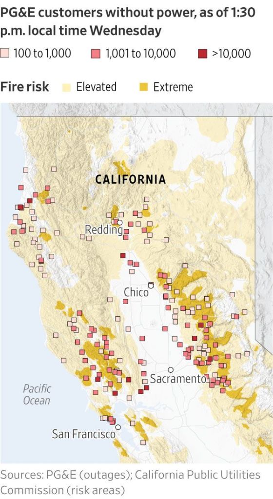
While the maps of outages seem to convey a weird spectral sort of precision, they suggest an architecture of emergency response that blankets all areas of the now legendary woodlands-urban periphery with darkness, as if in an attempt to rationalize the impending outages that have been paralleled with offers to set up cell phone charging stations, were hardly reassuring.. Promising lavishly to set up a designated communications network with its clients and customers, that seemed a bit like not allowing the news to get into the game, preferring texts, emails, and robocalls as a way of staying in touch and broadcasting emergency to folks who it assumed would have fully charged phones–because who lets their phones run low–though it wasn’t clear communications could continue if outages lasted the full “five days or longer” as announced. The company had its own private team of meteorologists, to prevent any redundancy from designated communication with the NWS or NOAA. But trust us, POG&E seemed to say–as Sumeet Singh, PG&E vice president of the Community Wildfire Safety Program, put it, “some of our customers may experience a power shutoff even though the weather conditions in their specific location are not extreme.”
The memories of the Camp Fire created a sense of disorientation before the impending arrival of high winds, which triggered a memory of the massive destruction of property and loss of lives even as the much of the nation is distracted on other media sources, and indeed by greater problems of irresponsibility. With the memories of the Camp Fire and to the North Bay Fires of the fixed in our head, from the toxic air they across the city, to streams of refugees who lost their homes, we had only just started to face the first evidence of the start of a new fire season in smoke from the first fires, which only last year had made Northern California site of the worst air quality the world, as we studied maps of how the Firefighters have made progress containing the deadly Camp Fire was tired to be contained. As we tracked the fear of fires growing not only near Los Angeles, but near Chico,
we faced a new beast in the unprecedented power shut-offs that became a possibility for hundreds of thousands of customers of the utility company over the last week, a highly controversial act that enabled power to be preventively cut to regions in California that we tracked through loopy maps of potential shutoffs, shown in alientating map layers that seemed to glow with radioactivity, as the authority of the utilities company had assumed in public life in California, elevated after a series of mismanagements or mishaps, meant that the combat of ever-present fire threats extended to the disruptive dangers posed by power shut-offs, perhaps strategic.
But the maps offered no clear logic to their arrival or creation, though they seemed to follow global curvature, akin Bowie net, though the GPS loops didn’t also overlap so often, and derive from power lines on a local level. The threat of interruptions of electricity seemed issues of global importance, altering access to electricity and shifting many to local generators–even closing the University of California for a few days until wind levels died down.

The large, privately held public utility company elected, with winds forecast from Wednesday through Thursday to reach velocities as high as sixty to seventy mph at taller elevations of the state, to adopt what was called “PG&E’s state-mandated wildfire mitigation plan, which aims to cut down on the ignition of wildfires during high-risk periods”–presumably because it was in bankruptcy, more than or as much as a form of public protection, at a time that PG&E has its back up against the wall. The widespread “voluntary” withdrawal of power supply was due to a failure of risk management, and the dangers of firestorms that could not be contained. The threat of electrical transmissions lines malfunctioning, collapsing, or igniting brush–as had begun the conflagration known as the Camp Fire of 2018 and the Tubbs Fire and the North Bay Fires of 2017, lead Berkeley residents to be asked to evacuate the Hills–an area where evacuation would be judged difficult in an actual emergency. The extensive elderly population dependent on life-sustaining electrical medical equipment–oxygenators; dialysis machines; ventilators–whose loss of power could pose diastrous health risks. Even the announcement of power loss could trigger panic sending customers into a tail spin.
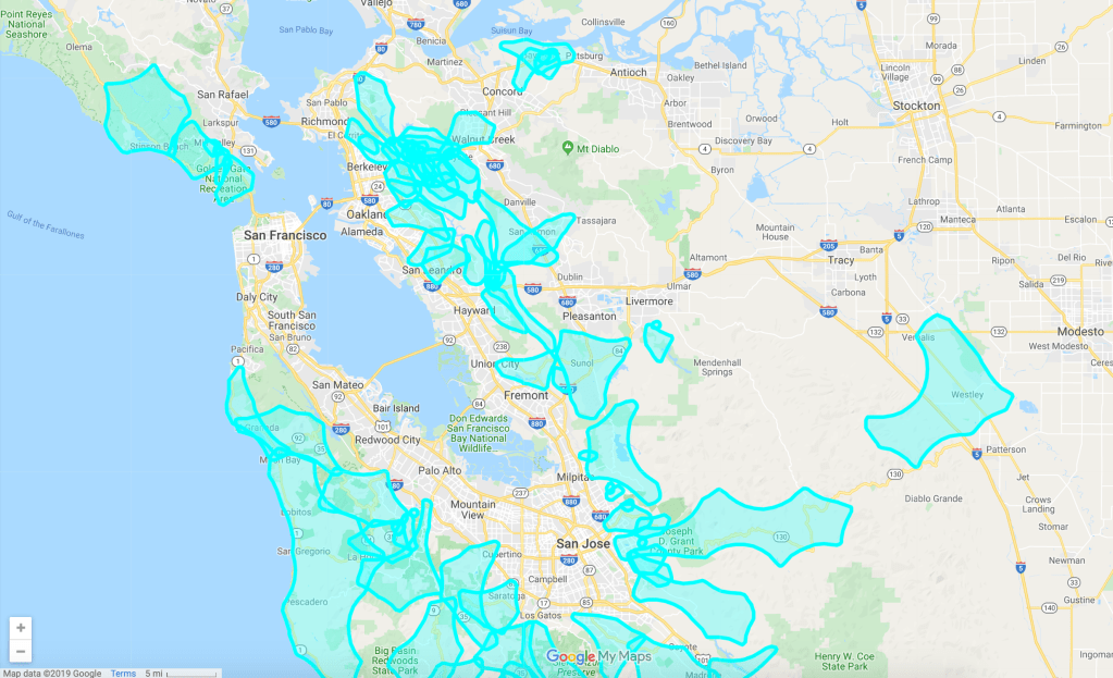
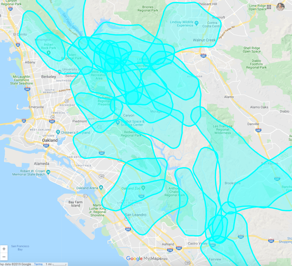
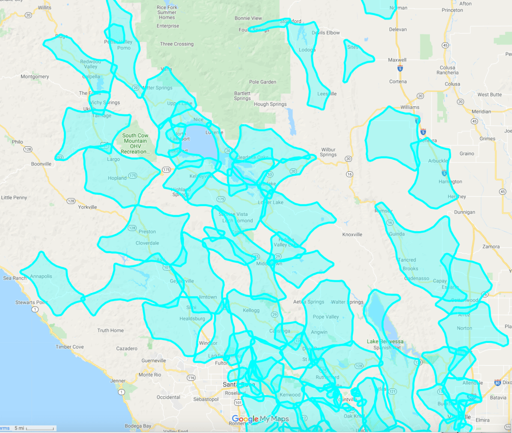
Since the potential outage map on the PG&E website first appeared, and before it crashed, significant panic grew as the need to follow a careful protocol seemed absent in the energy corporation’s plans. The maps revealed in complex if simple fashion a blanketing of many of the areas of the Berkeley Hills-based on what must have been the newly launched website PG&E had devised to help customers prepare for wildfires readiness, and indeed presented to the Berkeley City Council this past July about the potential for emergency ‘public safety power shutoffs’ and presumably also the need to develop a strategic response given the problems of residents who relied on electricity for medical devices, cel towers, and city reservoirs, who would all be thrown into disarray in the eventuality of a “public safety shutoff” that the energy company had recently acquired–or been forced–to adopt. The sort of outage map that PG&E distributed were low on actual information, and rich with apparent looniness and difficulty to read,–

–the image of state-wide potential outages even more generic at such small scale. The map is more suggestive of targeting of sites of past ties created by sparks from wind-driven fallen transmission lines or as a result of the sudden collapse during high winds of aging electrical infrastructure. All state residents were alerted to update their contact information to receive more local bulletins at pge.com/mywildfirealerts, a dedicated communications infrastructure over which PG&E held all strings; any possibility of confused communications was sought to be contained–as was that of examination of the protocol for delivering information within a dense patchwork quilt of transmission lines.
All residents in the state were asked to “identify backup charging methods for phones,” although what those were beside cars or hand-held generators was not clear, and to likewise plan for need for emergency refrigeration of medications, although what that would be wasn’t that clear for poorer folks, and what a thermos or solar refrigerator would allow was limited indeed. Everyone was enjoined to start to formulate their own safety plans. Fw really ever learned that the unexpected shut-offs might be actually announced at the moment of the arrival of high winds.
The issuance of such maps seemed as close to a strategy for responding to the frightening forecast of high winds, preventing all the wires from being live or carrying charge, by imposing an involuntary blackout on millions across the state as arrival of high winds. The warnings provided the basic metric to the agency, or stripping us of agency. The map strikingly mirrored the contours of the overlays appeared on GoogleMaps–the chosen medium that seems to acquaint us with reduced agency–although the ghostly images of past fires in previous years seemed as good a guide.

As if the reassurances of public safety outages would really help build customer confidence in the public utility that was ready to turn off the power on 800,000 people across the state. The aggressive “cautionary” outages for public safety seek to forestall the likelihood of conflagrations starting. The disruptiveness that they introduced without much advance warning may be an effective way to have their repeating past charges of culpability, as much as they map a future of greater safety.
As the lower costs of above-ground lines has encouraged more to be constructed, or older lines to be rehabbed, the map that PG%E holds of what structures are stable, and the extensive questions of engineering around sewage systems, water lines, natural gas and road widening, though the fact that above-ground lines were an eighth the cost seemed the most definitive basis to feed a growing real estate market by extending power lines into the woodlands-urban interface–the very regions that hug national forests, or bridge suburban sprawl with forested lands, where the flying of sparks can ignite wildfires rapidly from fallen wires and destroy entire residential areas of Napa: although the “wildness” of the fires was not so clear, they had come from the wild lands and on the borders of densely forested areas, and so retained the name.


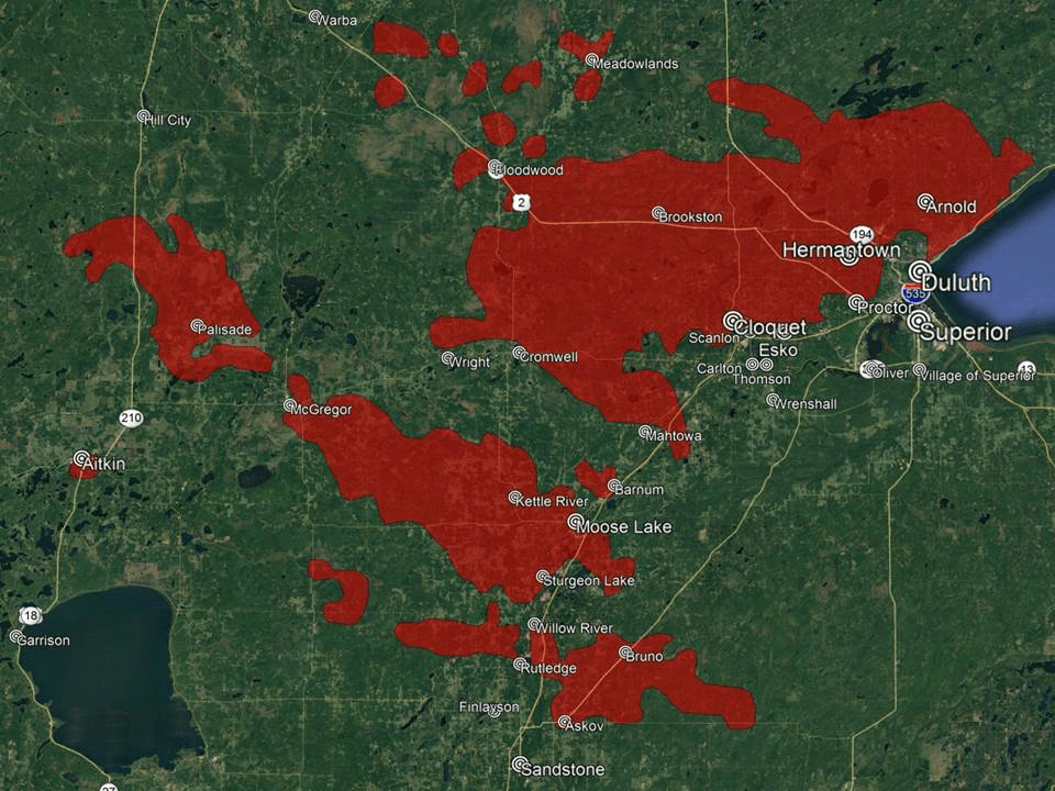
The broad areas of projected intermittent power outages seem designed to provoke panic and respect for the fact that they cannot be argued with any more, as their own unclear maps that should show what regions are most vulnerable to potential fires–lake the destructive Camp Fire that destroyed more property than any had in the United States since the 1919 brush fires of newly forested timbers had left piles of dried out wood. Unprecedentedly low levels of humidity and the sparks of railroads. The Cloquet Fires were not really “wildfires,” any more than the Camp Fire was.
Little “wild” remains across modern America, not even its purest products. Worries of wildland fires have escalated as extension of extra-urban peripheries have made so many regions of northern California wildlands the setting for a truly perfect storm–not only endangering wilderness, but more wildlands, those tracts with few or no developments, and interface with suburban–or urban–areas across the nation. The interface–present in Los Angeles’ “wild edge,” the spatial category of the “ecotone” where ecologists have located a new ecosystem dynamic, is as well a site of increased fire risk, as electrical wiring intersects with a wooded periphery, now without the water that it has long nourished it–it was the site of the Malibu fires that Stephen Pyne has described as the site of a “new fire regime,” in which a “lethal mixture of homeowners and brush” or of the built environment and the combustible wild lands magnify fire danger in specifically challenging ways, in what Davis called the “firebelt suburbs” of Malibu attracted residents unable to afford urban housing, subsidized by artificially cheap fire insurance.

The destructive nature of “oversettlement” of the wildlands-urban interface has migrated to Napa, Sonoma, and areas outlying Sacramento, attracted by a market for construction also subsidized by artificially low insurance rates, but rates that stand to climb, creating a huge real estate crisis in the valuations of lands. In many ways, Northern California is the “outer edge” of settlement; in 2012 it was already viewed as possessing high burn probability, but where high fire severity risk has not dissuaded many from moving, often to homes built before fire risk standards were adopted in 2008 to restrict building residences, and few homes have had new retrofits to accommodate the dangers of a new fire regime; Napa has added new fire alerts since the October 2017 fires, as well as video feeds, but rural residents are instructed to “prepare” for fire seasons and eventual evacuation in ways few expect to be broadly enforced.
This was not always the case. Acknowledging a landscape of high fire risk echoes the cost of fires acknowledged after the Great Slash Fires–now areas of low burn probability–spread across much of the once-forested midwest, creating the flat landscapes of grass and high plains often now converted to farmlands. Fires typified by the “Cloquet fires” were not based in Cloquet alone, but spread across northern Minnesota destroying towns in a Holocaust of destruction as World War I was fought, bringing the violence of the front lines of war to the home front, in 1918, shocking the country as massive fires endured for multiple days, few survivors stowing themselves in basements only to emerge to see a landscape without homes. The fires had moved with unprecedented velocity among extremely flammable huge piles of cut slash that generated veritable seas of jumping flame at the start of the twentieth century; quickly growing out of control under high winds, firestorms left lasting scarring on the environment; the firestorms had similarly advanced with rapidity and escalating heat among piles of chopped, dried brush often set beside rail tracks–and can be almost read retrospectively in maps of the fires’ footprint that extend far from the city itself–following both where the winds drove it. For the fires leaped between wastelands of slash that loggers had left in piles across a landscape once populated by white pines in Michigan, Wisconsin, and Minnesota, flames creating a huge footprint often spread by sparks carried by high winds.
In a somewhat similar manner, only last October, the Camp Fires spread ninety miles north of Sacramento, streaming columns of smoke across California, over 180,000 acres, across a region that had experienced some thirteen large fires since 1999, and was not really just “one fire” but as the Atlas Fire of 2017, fourteen large fires that simultaneously burned rapidly in ways impossible to contain across eight northern California counties, revealed a new landscape of fires’ spread with immediacy we have yet fully to process in adequate ways of fire response. Several fires were attached to PG&E powerlines, perhaps either poorly built or aging, that may have toppled in the face of high winds, but destroyed houses and entire communities across huge discontinuous regions, driven by winds, sparks, and fire whirls generated at high temperatures.

The shock of the fires set standards of fire readiness and preparedness that helped prepare firefighters for this year. The Cloquet fire had first raised questions of responsibility in the late nineteenth century confirmed by disturbing incidence of the timing of the fire after the first downed power lines with the start of the Camp Fire. Although the origins of the fire may never be confirmed, the first reports of a down power line and transmission outage justt fifteen minutes before the first reports of the fire. PG&E dispatched firefighters with haste “under the high tension power lines” is where CalFire located the blazes’ start, to a difficult to access vegetation fire on Camp Creek Road, acknowledging “Copy, power lines down” at about 6:43, that rapidly spread that day to over 100,000 acres that Thursday, leaving the skeletal remains of standing chimneys isolated in blackened concrete foundations, creating creepily uninhabited smoking area that was soon, as if we needed the graphic reminder, able to encompass a good.
The toppling of transmission lines would lead the utility to be given the power to disable power lines in times of emergency, a power that was first used only the year before, when PG&E began the practice of shutting off power lines after the terror of the 2017 North Bay fires had already spread across the “wildland-urban interface” rapidly expanding in the state. The Camp Fire spread due to downed power lines. The ability of shutting off power must, of course, be successful only if one has foreknowledge of what structures are weakest, or has already trimmed back trees from the lines that may topple. Neither was done, however; the electrical towers that collapsed before Camp Fire–part of an infrastructure original to the Upper North Fork Feather River Project, or date to the early 1900s, which PG&E had somehow been granted public permission to replace aging line with new wire–without changing the aging structures that supported them, which indeed collapsed.

None of the fires were “wild.” The designation helpedd PG&E disown responsibility for damages, however; declarating corporate bankruptcy avoided paying compensations that those who lost their homes, property, or loved ones might have deserved. Despite announcing the intent to cut off power along certain lines as the Camp Fire spread, the “plan” to cut off power only days before the Camp Fire began was deferred–as multiple fires that consumed the region in such an extensive conflagration began from how at least two–and possibly more–conflagrations erupted along live power lines, that the power company never explained; their spread covered the countryside with smoke, but elevated regrets at aborting the interruption power, as if this could contain the blazes’ furious spread.
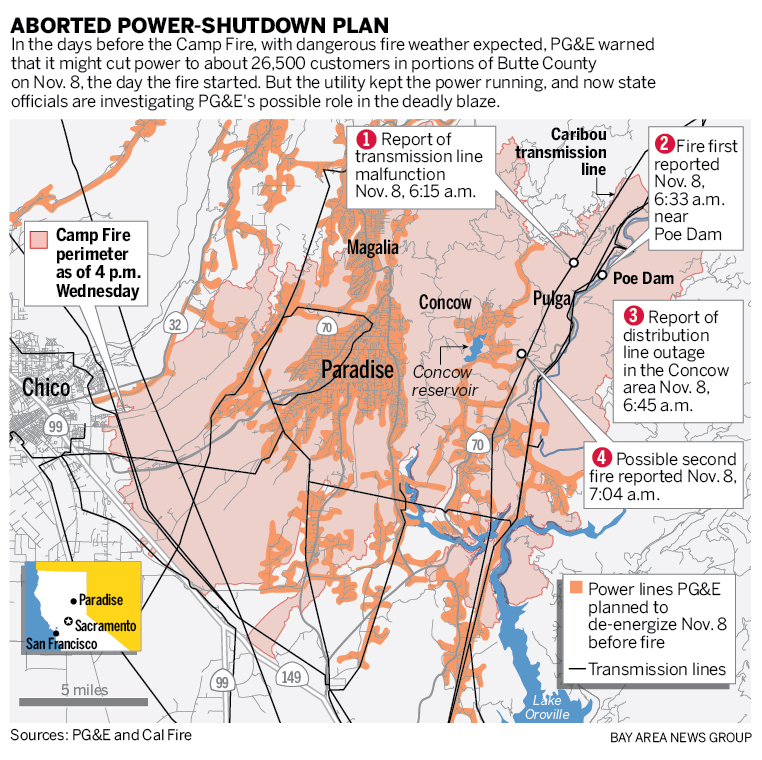
The map of the “aborted plan” must have made rounds in board rooms at PG&E, and been mulled over by the new CEO, if not in his hiring process. But what Davis attacked as the “destructive overdevelopment” of Southern California to meet the demand for beach frontage has been paralleled in the expansion of towns like Paradise in the hills outside Sacramento, as in Butte County, or the expanding edges of Santa Rosa.
This time, the result of stripping of power in areas tied to elevated or extreme fire risk lay along the same urban-wildland interface and extra-urban perimeter. The preventive Public Safety Power Shut-offs seemed more a hopeful band aid to cover corporate responsibility for future fires; the failure to trim trees and repair damaged power lines that would have been possible causes of updated conflagrations; despite judicial reprimand after discovery just last autumn that the private utility company had used the funds it was assigned to trim trees in order to pay shareholders dividends $4.5 billion to continue to illustrate the company’s profitability: the lame defensive response of the PG&E lawyer merited eye-rolls–““There’s a lot of trees out there, and we don’t have eyes on all of them;” if literally true, the intentional overlap with extreme risk areas in bloated urban perimeters seem a gambit to ensure that if lines weren’t fully repaired, they just won’t carry charge that could lead sparks to fly. While the “argument” of this map in the Wall Street Journal raised questions about the publically traded energy corporation, and its ability to continue electric shut-offs as a form of fire protection, it casts doubts of the ability of any one company to “manage” firestorms effectively after expansion of housing within much more inaccessible wilderness areas.
In ways that seem based on risk maps of wildfire to update areas of actual risk, and focus on the increased appreciation of areas of Wildands-Urban Interface, beyond outdated models of “risk” that CalFire had generated of “fire hazard severity” back in 2007, before the occurrence of some of the more devastating fires in the local landscape.


The occurrence of the Camp Fire had, after all, led California’s largest publically traded utility to enter bankruptcy and process up to $30 billion in fines it is unable to pay, and to maintain the sense or facade of its ability to maintain, respond, or oversee a state-wide safety issues that may be well beyond its control. The state utility company was blamed for failing to maintain the safety of its transformers after openly recognizing that the poor state of its transformers led them to be the “point of ignition” of the recent tragic fires, exposing itself to$ 11.5 billion in damages for the most deadly fire in California history that spread across 150,00 acres. The admission that it was responsible for the site of ignition of the firestorms that destroyed Paradise, CA had led it to declare bankruptcy as rains pounded the state and inundated much of the coast, leaving the specter of future fires and problems of future fire management lay both in the distant past and unexpectedly close at hand.
For far more strikingly than previous fires, the inescapable nature of ties to global warming was eerily paralleled in how the fire displacedover 50,000–a marked increased in the concentration of evacuees without place to stay in rural Butte County, a year after 250,000 were displaced by the Woolsey Fire in more densely populated Southern California, and tens of thousands displaced in Sonoma in the North Bay Fires. The rapidity of the spread of both the Camp Fire, as the North Bay Fires that destroyed 8,900 homes across Santa Rosa, in an area recently adding homes and residents at the rapid rate of five hundred houses annually, created a level of displacement atypical for the area, eerily familiar. The images reinforced ominous links to global warming, and the growing vulnerability of the state to a plague of fires that PG&E found itself lacking resouces to manage. The final tallies of dislocate, dead, and property losses seemed empty as we have little sense of the tallying of such data, and little ability to map the expansion of risk across the drying out landscapes of northern California.
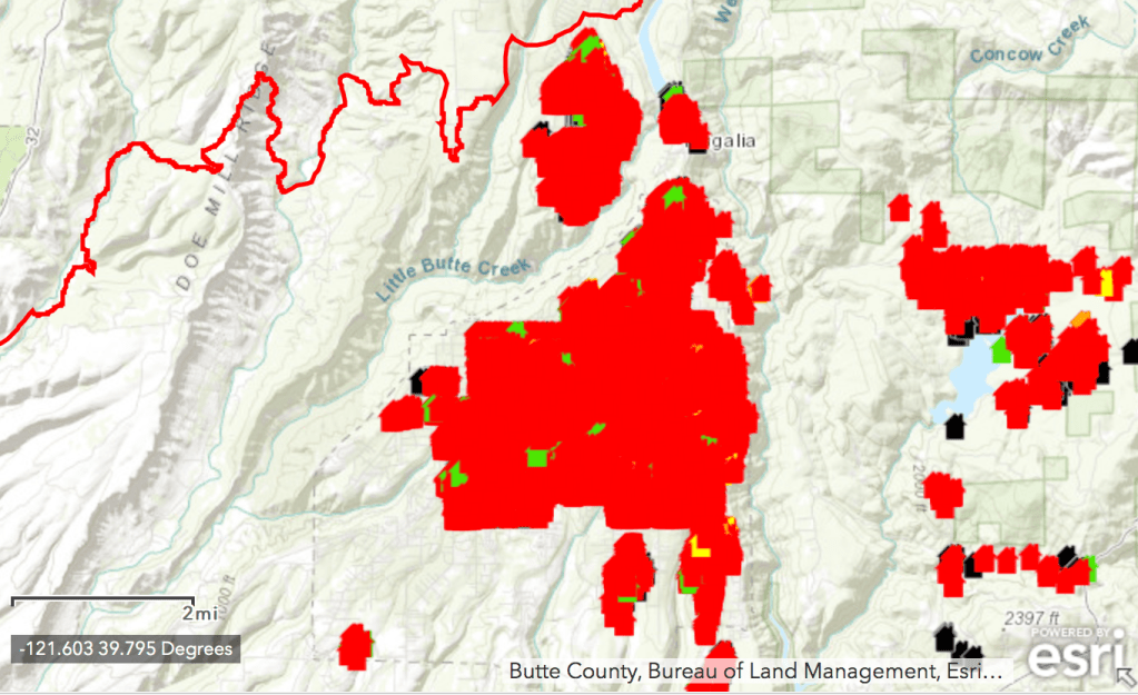
It made sense to take stock of whether inadequate management and poor oversight directed against an energy company that combines gas, electricity, nuclear power, and hydropower, are warranted its break-up. California’s legislature had tried to extend support to the utilities company in the wake of previous fires to spare it from previous wildfire liabilities; reluctance to extend any similar security to PG&E has turned to anger in the face of the new level of destruction, as if it might be a new normal, and outrage at the scope of the devastation of local neighborhoods, and the scale of the over 18,000 buildings consumed in the Camp Fires alone, in dat4a maps placing their absence at red pinpoints within a far broader fire perimeter encompassing lakes, rivers, mountain ridges, interstate roads, and reservoirs.
The cumulative disasters of the Camp Fire, North Bay Fire, and Tubbs Fire all respond to the eccentric weather patterns the state has faced after facing far less rainfall, and questions of whether the maintaining the safety of the energy structure, as PG&E confirmed damage to an a fallen arm of an electrical transmission tower only minutes before the Camp Fire began its apocalyptic burn on in Butte County on November 8, soon to spread at unprecedented speed and high temperatures. If a fallen transmission line had not indeed led a PG&E worker to call 911, the leveling of charges that failure to replace worn-out towers and other equipment would not have lent credence that they had unwittingly allowed the fire to spread; raising questions of guilt combined with charges of poorly and improperly maintaining forested areas and trees in such close proximity to electrical wire. There was less attention to the “guilt” of the parching of a landscape that lacked rainfall over multiple years, that encouraged multiple combustive wildfires to arise and scorch the North Bay in October 2017. Since the as the corporate entity has become blamed on inadequate repairs, maintenance, or poor record keeping, it seemed bad practices left state residents increasingly vulnerable, as President Trump was allowed to tell the false narrative that the spread of fires in Northern and Southern California were essentially due to “gross mismanagement of the forests,” the notion of blaming the utilities company for negligence seemed more credible than registering how desiccated glass land had created a new geography of fire and of firestorms’ spread–revealed in images of the fearsome spread in an absence of any moisture.
Evidence of suchinadequate supervision, meeting of safety criteria, and inadequate oversight by the state-wide power company–whose gas and electric units have permitted increased funds to be invested in clean energy–had identifeid the spread of California fires with a “bad actor,” fueled by its decision to file for bankruptcy and tragic memories of the disastrous 2010 San Bruno gas pipeline explosions and charges of continued pipeline safety violations have led the investor-owned energy company to act in ways that run against the public interest, and accusations by state regulators that the utilities company had falsified gas-inspection records. So this time, things were different. Yet it is also true that the fires combine the threats of global warming and low precipitation with that of poorly maintained and aging infrastructure, from which the legal sieve of liabilities has left the energy corporation exposed, and indeed an uncertainty of how to respond to the realities of global warming and climate change.
The private company used the fact to its benefit that it continued to hold the strings of suspending power in times of emergency now raised questions of who deserves power–or whose power can be cut–as if this passed for a best practice of actual readiness, and the problem of unseasonably dry autumn weather, of the sort that is starting to begin again in Northern California. And so, facing the potential of further threats in this change of seasonality in an era of increased warming, dryness, and decreased humidity with high winds in the forecast, PG&E somewhat providentially decided, although they had not tried to trim back trees or dead wood near power lines, to undertake a set of unprecedented “planned shut-offs” or randomly announced events of suspending power to customers, in ways that seems destined to only widen the gap in public trust of the private utility,and make us wonder how these maps were determined, if their logic were not already pretty clear, given how they seemed to shroud or conceal yet again any responsibility of the very areas of high fire danger in the wildland-urban interface where fires have tended to erupt in recent years.

Or perhaps the problem was one of creating the lowest amount of vocal pissed off customers-
For the aura of responsibility that PG&E assumed in issuing such vague if high-handed declaration seemed to suggest something like public stewardship, haunted by the decision of the utility company to fail to proceed to shut down power around Paradise CA. PG%E had informed customers only days before of an impending shutoff in response to a forecast of high winds, even though the National Weather Service, ever more attentive to local questions of weather conditions.
The state indeed had issued a “red flag” warning that blanketed much of the Northern California interior–

–up until the very morning that Jarbo winds formed and knocked down power lines near Camp Creek Road off the Feather River, attracting PG&E workmen who observed the growth of the fires by 6$$ am in the morning, as it grew beyond ten acres, and airborne observers not that the power transmission lines were down across extremely combustible dry wood that rapidly spread, even before sunrise, to a dangerous rate of growth, although high winds prevented aerial observation through much of the day as fires spread through untrimmed forests and desiccated undergrowth.

While the sort of cut off maps of power suspension that PG&E, which already has declared bankruptcy, having been placed on strong advisory for its lack of public responsibllity in the face of the San Bruno gas pipeline explosions of 2010 destroyed residences in an urban neighborhood that devastated fires and created a conflagration in early September, nine years ago, just two miles west of San Francisco International Airport, as a thirty-inch steel pipe exploded, having been placed on probation–

–lead them to be assessed even steeper penalties after reports of knowledge of damages to the transmission towers whose collapse led to the Camp Fire’s devastation that consumed Paradise, CA, began a practice of sending out maps of oddly authoritative loopy circles where shut-offs might occur that oddly mirrored the very woodland-urban interface where fires, also perhaps due to downed power lines, had set off the North Bay Fires of 2017, when a set of four major local conflagrations grouped as the North Bay Fires had destroyed houses in suburban and extra-urban areas that had grown to lie near “wild” lands, an increasingly large area of density overlap generated by the expansion of outlying towns near San Francisco, driven by local rising real estate prices to expand rather hastily into what were recently pristine wooded areas. The improvisational expansion of this “interface” has created overloads in the current born by old electrical infrastructures that were not sufficiently stabilized to encounter such high winds–as well as located an expansion of power lines, or reuse of older structures, in less accessible or indeed remote areas poorly serviced by roads.


–as increasingly active dry, high winds from the north and a hot environment of a dry fall weather had intensified over eight months with sudden rapidity of its aridity, that had qickly produced the preconditions for a fires to spread rapidly where power lines were not secure, or near tall tree limbs and downed–that would threaten much of Santa Rosa that had already extended into areas ofhigrh fire alerts.

The outlines of these contours of fire dangers seem indeed to explain the fairly loopy outage maps that PG&E now decided to regularly issue, perhaps as they had failed to trim trees or reduce brush, or repair infrastructure, over the very same areas where fire alarms had been intense–or just to deflect responsibility by their indication of an attempt to promote the public good–

-even if not to describe the rationale for doing so, demanding their customers accept in on sheer trust in their detail. The clarity with which some of the earlier maps PG&E released Tuesday evening to justify the sudden spread of outages as based in clear-headed preventive measures suggested little grounds for comfort beside the wave of alarms and inconveniences that might have been occasioned by a clearer thought-out roll out. The problem was, however, in the end all about the maps–what were all those blobs, and did their dense crowding have any logic or did they just seem drawn on the map based on probabilities of fire?
In the Bay Area, it seemed especially notable to this resident that the areas of proposed five-day outages mirrored or echoed the very same regions where the danger of ember-born fires in the face of high winds had emerged since the Oakland Hills firestorm of 1991, whose geography was now eerily echoed in public memory. For in the East Bay, where I live, we were sadly, all too familiarwith the rapid spread of firestorms across dry hills: images of the fires’ spread sucked all air out of the room, and seemed to remind us we lived in a lost, disappearing, and vulnerable landscape that was particularly precarious. We felt a sudden and immediate sense of loss while watching the almost unprecedented intensity of their spread. Before the limited storytelling ability of point data maps offered so little access to the topography of the fires; we often felt as if we were without clear orientation to them–strikingly similar to 1991 Oakland Hills Firestorm, the third costly urban fire disaster after the 1906 earthquake that hit San Francisco and the Great Fire in Chicago of 1871, whenloss of so many homes, lives, and property scarred the landscape in ways that have long haunted the region’s imagination. The fast-moving nature of fires in semi-wooded areas, fueled by dried out areas of trees, evoke how the Oakland hills fire grew by being fanned by dry winds, its combustibility as a firestorm fueled by petroleum-rich eucalyptus that exploded regularly to punctuate its course.
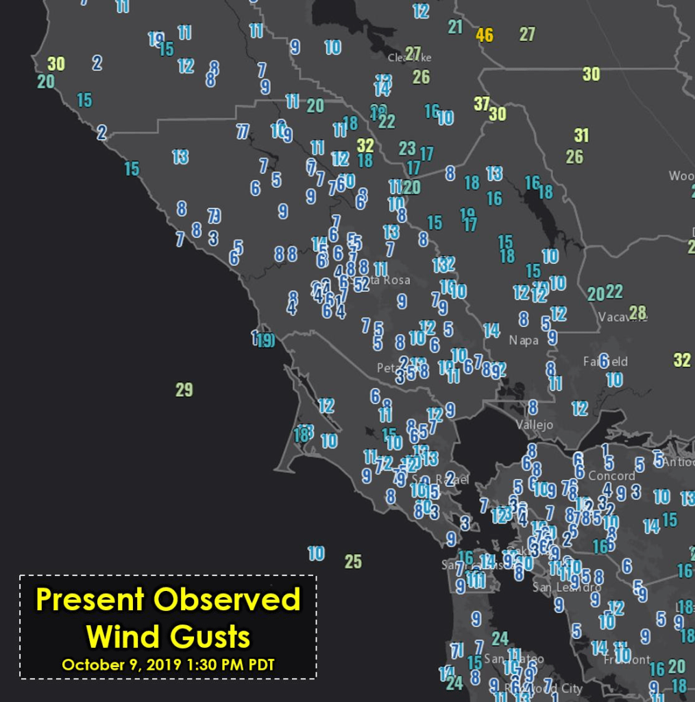
The North Bay Fires released over four days some 10,000 tons of particulate matter of 2.5 microns or less–more inhalable solid and liquid drops as all on-road vehicles in California in 2014–and a cascade of particulate matter released from the expansion of the Camp Fire has created a hazardous level of air pollution between 150 and 200 from Friday, almost exceeding 200 AQI of small PM 2.5 in the air, pollutants to which vulnerable elderly, infants, and children, and light winds limited smoke dispersion, leading the city to provide all residents with free respirator masks. The air quality was the second worst recorded in twenty years, only second having been their more proximate the North Bay Fires that belched smoke for four days. Smoke from the North Bay fires was not nearly so often mapped as the huge losses and destruction, on the ground, and the evacuations that they so hurriedly created, filling the Bay Area and beyond with immediate panic as they would remain uncontained for the two weeks after starting the evening of Sunday, October 9. We raced to keep up with them consume more and more acreage, fire fighters striving to contain them, waiting for high winds of over fifty-five miles an hour to die down, as many prayed for the arrival of rain.
Dry branches and dried grass had provided a parched landscape of risk that fed intense fires, which spread fanned by high winds on Monday that the combustibility of the land from fires usually higher up in the hills that had spread to housing subdivisions that crowd the freeways, burning up homes to the ground instantly even before fire departments had arrived, to watch theirspread, when few had any sense of the huge risks of such unprotected environments–despite therecent issuing of red flag warnings of high fire hazard by the National Weather Servicefor the entire region September 1, and even despite the alerted issued by the National Weather Service for the regionthat the moisture levels of Bay Area vegetation had dropped to record lows only hours before the North Bay Fires began. Fire risk had multiplied by the copious growth of now-dry grass and brush spring rains in much of northern California, which had rapidly dried in a season of record heat: the record heat this summer accelerated by severe drought that was not registered in many maps of the fires’ spread; it had also created a landscape for the Diablo winds to wreck havoc.
The smoke that emerged from their rapid spread, and plumed over the San Francisco bay in thick clouds dispersing far beyond any site, would Bose other risks. The altered far more than the local atmosphere, covering hundreds of miles, and begging us to map the new relation of place to national space, and fire danger to the atmospheric commons. What CALFIRE calls the “October Fire Siege” of California included twenty-one major fires, wildfires that have burned over 245,000 acres, California’s “Fire Season” now lasts from the start of summer to winter rains, or as much as 220 days, as heat creates conditions for more extensive fires. As over 5,700 buildings were quickly destroyed, and over a 100,000 displaced,the destruction of the lands just four hours drive away was eery to observe from close by, whose level of damage seemed incalculable, both from the lives lost and the scarring of what was long considered a protected area. From 115,000 consumed by wildfires Monday, on Wednesday wildfires had consumed 170,000 acres, whose number rose over 200,000, with over 20,000 evacuated from their homes. Troublingly, there seemed an odd bargain between the relative poverty of a storyline in the rich data layers in the maps of the fire, hastily assembled from data layers and satellite readings to provide a snapshot focus on events.
The actual limits of these maps may have lay in their construction to grab visual attention. They seemed to sever them from any perspective on a broader, global context and isolate the shock of image of destruction from a broader historical narrative: the shock of image of destruction was removed from a broader narrative, and from human presence in the region. As we heard of hundred of evacuees, and mapped evacuation zones, the spread of the fire was described as driven by amazingly high Diablo winds, of unprecedented strength, that refused to let up; less attention to the heat of the summer that had dried the land in previous months ,thtn this immediate cause; the tendency for increasing winds in the future, driven by high pressure fronts of the Great Basin, and creating record-low humidity in the air that was usually moist, and drew moisture and cooling from the sea most month. Signs at entrance to parks and public lands throughout the Bay Area alerted locals to extreme fire risks.

The intersection between built environment, electric power lines, high winds and a drying out landscape make the fires hardly “wild.” The challenges of containing the wild expansion of the fire and its inability of containment might not begin from the extent of smoke that they generated over the bay area and beyond, laden with heavy metals and plastics, raised the problem of mapping the atmospheric challenges of fires. They are as good as any to start to talk about the multipliers of climate change that multiplied the effect of these almost spontaneously arising spread of twenty-one fires over the north bay landscape that were difficult to contain.
Growing fears of spark-driven storms along hillsides may underlie the alleged scientism of those spreading torquiose loops of regions that define the design of a local electrical outages map. They blanket the very regions the hills fire had destroyed. Would outages even address the issue, or should the only real response be to end electricity for the month of October and November, and just hope for the best? The closure of many important areas of work–including the University of California at Berkeley–seemed to be guided by a rationale of insurance and the problem of not being able to cover its own insurance abilities or costs financially, and a need to project public confidence to keep the for-profit company alive in a season of renewed worries about the inevitability of fires.


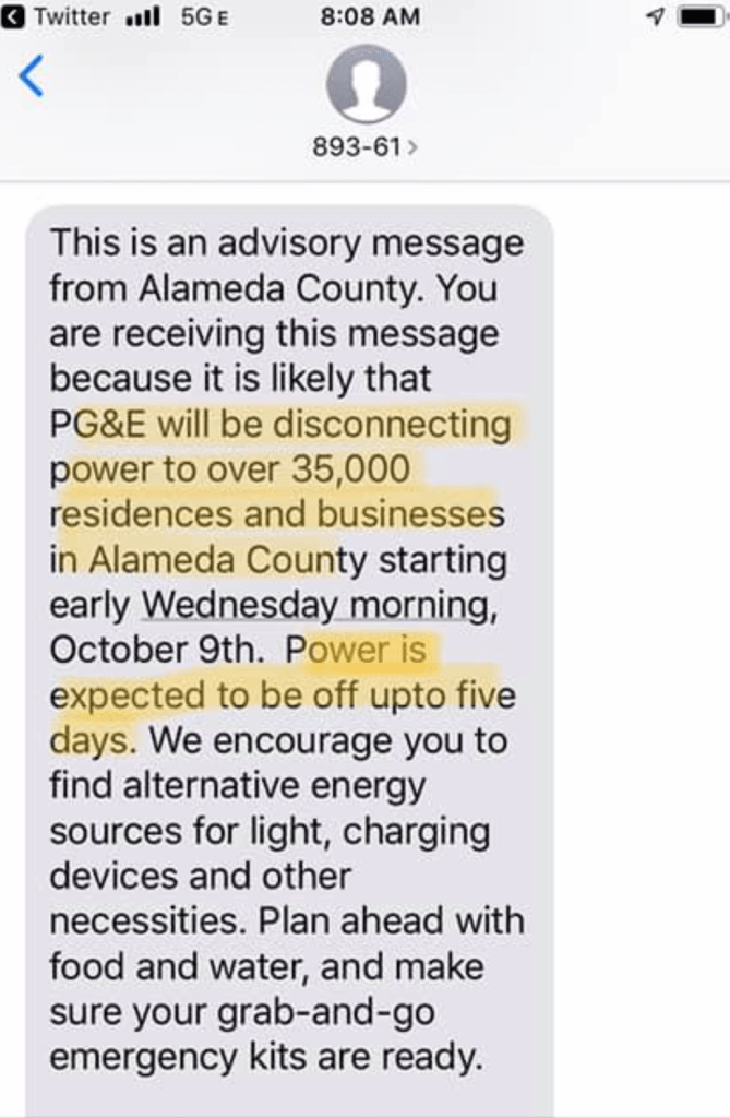
The power of making such random power-cut offs has rationalized the anonymous omen-laden “advisory messages” sent in batches as text messages to the residents of areas that on high, offering vague “encouragement” to all to locate alternative energy sources for light, although providing no funds to do so, and oblivious to the dangers posed to those on medical devices–such as lung machines, ventilators, respirators, and even CPAP machines, or medications requiring continuous refrigeration, let alone those without possibilities to refrigerate their food, heat their homes, keep lines of communication alive, or ensure their burglary alarms, let alone charge their electric cars. The vague hope of locating “charging devices” as if they could provide power for five days, after which high winds warning should hopefully magically subside, was massively improvident, and ill-conceived.
They seemed only destined to stoke panic and uncertainty, coming in an oddly empowered voice from on high of those who had been sanctioned to make pronouncements about withholding energy sources for the ostensible public good, although in fact only as a preventative measure to compensate for lack of preparation by trimming trees or ensuring the stability of a safe energy infrastructure that had grown to expansive, and just too old, to be fully repaired, and from which they wanted some exoneration, as they had already declared bankruptcy, even as they had paid out large dividends to investors on which the private company relied.
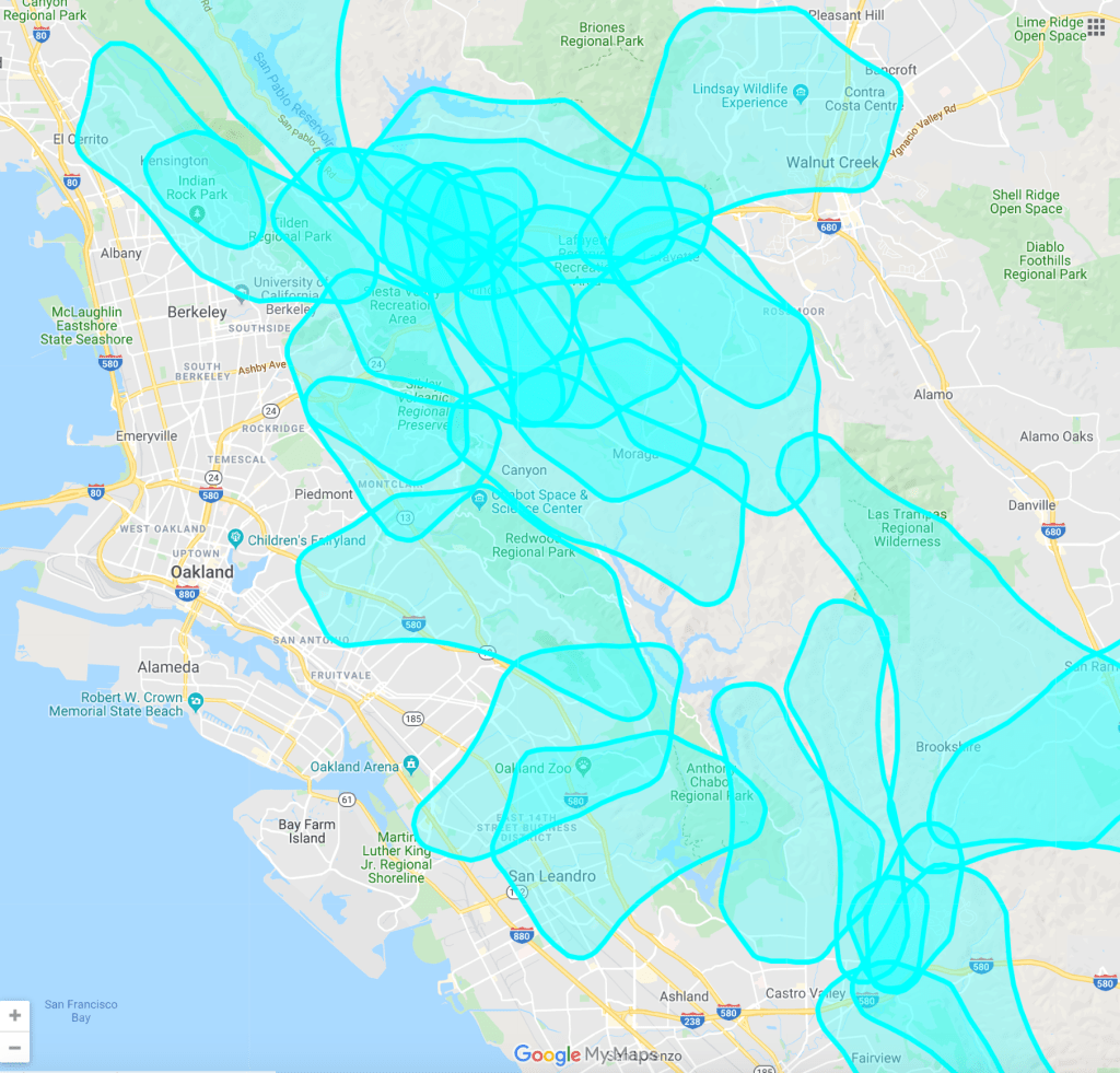
And so emerged large, loopy somewhat authoritative turquoise splotches of zones subject to sudden almost week-long shut-offs, creating waves of panic among those needing to refrigerate medications, breast milk, or formula, that allowed women to keep working apart from their nursing infants, and infants to have a reassuring home. The related problem of a failure of electric stoves, white noice machines, or even answering machines, internet, and email servers was hardly appreciated or addressed, seemed secondary. Those broad loops of intense turquoise traced the Wildland-Urban Interface–or “WUI”–ironically perhaps primarily intended to try to project assurance that PG&E knew what it was doing due to some crystal glass, the effect was probably the reverse; the company seemed to have replicated the zones of danger anyone could predict, or where its own losses might be proven to have been its responsibility, as if any area that could be credibly tabled at risk due to the threat of falling lines bearing charges were possible and not just pronounced.

The broad areas of the Bay where power would not be shut off presumably included those areas where the economy could not take it–the more powerful in San Francisco, for example, as if their power lines were not often also above ground, or the entire region of Silicon Valley–that Valley of Perpetual Illumination, whose servers run so much of the opaque economy of the internet, from the dark world of YouTube and Google to the algorithms of Facebook and Twitter, which has shaped so much of our own distorted sense of politics and what passes as political opinion. It might be better known as fearful huddling for reassurance and ostrich-like removal before actual social and global change,
The loopy surveying boundaries that recall the first attempts to map the United States on geodetic grids by centroids that map the organization of Bay Area outages emphasize the skirting of Silicon Valley, and the peninsula, evident in later maps. Green splotches in the maps that PG&E issued immediately from the administrators of schools, hospitals, and other institutions seem to reveal blobs that were absolutely without information that could be drilled down into, save designed to communicate some reassurance that the outages would not effect Silicon Valley, whose databanks would continue to hum in the background, as a noise machine, as a totality of outages would indiscriminately blanket much of the Bay like a patchwork quilt of yellow seams which seemed improvised.
They rapidly diffused on the internet to residents seeking information hardly designed to ensure public trust that the highways would have signage–even if most have utility generators.


Even as more seemingly sensible maps continued to appear, always committing San Jose, where power lines run mostly underground, it seemed quite remarkable that a company with a large mapping crew had no contingency maps for public consumption. PG&E seems to have just realized–after months of alerts of record high national and local temperatures from June through September–that it had no persuasive maps to show to its customers, perhaps as the company’s funds had been stressed on continued dividends.

While Silicon Valley hummed, entire regions of the removed and rural regions might be subject to unannounced outages, we were asked to kindly prepare for the worst on their own, with electricity suddenly cut off for up to a week at a time, and no compensation for the disturbances that this might cause. Was this not only another way of preserving a deep inequality of local governance?
As if to piss off the minimum of people, most of the projected outages lay in less populated areas, lest pandemonium result.

What could describe the huge extent of areas that were now up for electricity rationing, projected by an unclear logic onto a Google Maps as if with its own rational authority,–but with no real explanation for where the divisions of space lay, save of those areas where a lack of streetlights would bring sheer panic?
The ghostly blue loops reveal contours of denial of responsibility by the privately held electric company lying at the edge of bankruptcy, as it tries to subtract risk after a summer of increasingly rising temperature anomalies, as if all it can due is throw up its hands in hopes of seeming it is preserving the public interest. If the rise of unseen temperature anomalies at the very start of the summer of 2019 brought record temperatures of the drying out of the most densely forested areas of Northern California, and raised fears of another spate of coastal fires as predestined for the later summer months, the rise of a fall of truly unforeseen temperature increase from NOAA by September, when the entire nation was at its record warmest–


–may have raised the levels of attention and concern to global warming that shook the inexplicably continued trust in the elected President who steadfastly denied that global warming and climate emergencies were human-made to its bones, clearing the metaphorical underbrush for impeachment, as no one knew what to do with the levels of dying underbrush across the nation.
And the rise of the weirdly disorienting maps justifying electrical outages, while assuming the emergency powers that PG$E had wrangled out of public utilities and safety monitors to shield itself from responsibility was on display in particularly eery ways in Berkeley and the Bay Area, as quite unpredictably loopy regions were used like a mosaic in order to blanket much of the more wooded regions of the East Bay–in this case, it seemed that most of the non-urbanized areas, and many of the poorer areas of East Oakland were slated for prolonged power outages, without any sense of or oblivious to the scale of unfairness of the topography,

–so that the only regions where outages would not occur seemed to be where they would benear highways or freeways, as if to ensure continued traffic signs on larger public arteries, often creating meaningless overlaps amongst turquoise layers and overlays on some regions that provoked increased danger–from in a somewhat Machiavellian usurpation of powers that something akin to a rather deep betrayal of public trust verging on a true absence of a sense of public responsibility.
The greatest difficulty with these odd maps of circular rings of outages that shows a land haunted by irregular loops, that seem akin to surveying practices, is that they distance or are distanced from the hidden role of global warming in the creation of the setting of the potential spreading of flames, reducing the lay of the land to a logic justifying the spread of outages and electrical shut-offs in high-winds circumstances, rather than instructing folks in the increased importance, more needed than ever, of maintaining defensible lands, cutting back dead weeds, grasses, and branches nearby to residential houses or building complexes, and indeed securing land in the face of the changing scope of fire dangers. To be sure, the spread of earlier fires in the wildland-urban periphery intersection were haunted by a new proximity of trees, power lines, and houses, and the spread of fire along tract housing lots that were able, in both Santa Rosa and in Paradise, to skip from house to house, as buildings became infernos whose explosions communicated the firestorm, whose growing intensity and heat was unable to be contained.
The maps of outages seem haunted by this new geography of fire, but a geography that leaves the older preventive measures for fire safety aside, and suggest an alarmed disorientation at the new pressure of fire spread, fire intensity, and fire communication due to global warming. The older town construction oddly echoed the photographs of the Berkeley fire of 1923, which left blocks punctuated not by trees, specked with isolated brick chimneys, like potlatch towers of a primitive society, eerily stripped of the houses that they once housed, that Oakland photographer Harrison Ryker rushed to take as it burned, arriving after high winds had overwhelmed the abilities of the Berkeley Fire Department–who were challenged by insufficient water supplies, as well as high winds–to contain it. The fire ran almost to the university, which thanks to a separate and less strained water supply was never breached, although often depended on undergraduates supplemented firemen by patrolling the perimeter with buckets.
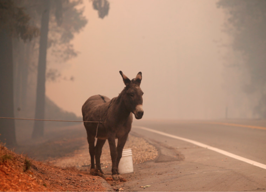
Looking at the tragic photographs on the outskirts of Paradise, where photographers on the ground must have rushed to capture the pathos, no doubt wearing masks to prevent inhaling particulate matter, captured eery images of the burning houses, which most of us watched. No luck for the images of stranded people, destitute skeletal frames of burned vehicles on the roadside, or tragically stranded wildlife or burros brought to the hilly region, where the loss of animals, and consequences of intensive smoke inhalation, demand a multi-year census, if anyone needs a project, as does the soil and runoff quality of the North Bay, which is being studied with far greater attention and care.

Containment became the primary problem, at the intersection of the man-made and natural landscapes–even if the difficulties that the Berkeley Fire Department faced weren’t analogous, or even the extreme intensity of the slash fires of the late nineteenth and early twentieth century, through the first World War, and up til the 1930s, were probably more similar to the huge intense heat that piles of cut slash could unleash on a dry summer, when winds bore or carried the immense heat build-up that slash fires could consume, which were able to flatten entire towns in the Midwest, forever altering the landscapes of once-wooded regions of Wisconsin, Michigan, and Illinois. The slash fires indeed prepared the flattened meadows, prairies, or corn-fields of those states, forever altering regional habitat. Entire areas were regularly replaced by conifers and mixed spruce and fir were later known as “asbestos forests” with pride, on account of their inability to burn as quickly; that highly flammable slash–the result of a slash-and-burn strategy for plant cash crops like corn–was regularly, in the early twentieth century, often lit by sparks from railways, created conflagrations that lead to huge devastation and displacement.
Thee footprint of the Camp Fire was traumatizing as the fire grew in ways firefighters had no clear recourse to stop, or to map, as acreage continued to burn beyond the devastation of November 9: without any clear code to follow in many of these Sierra outposts on the Feather River, without a hewing to notions of defensible space in many of the extra-urban areas, the fires spread quickly with no clear response strategy in place–and no clear evacuation procedure imagined, in areas far more dense, and should be thought of not only as green rolling hills of the Sierra Nevada, as an expanding sprawl of housing whose growth has in fact helped to kindle and create the high-intensity fires. The fires would not, with normal humidity, have occurred in the Feather Rive Canyon.

The unprecedented destruction of houses, property, and people in the Camp Fire was undergirded by the low humidity of the region, and the local anomaly of rainfall, and the intersection of climate change and extra-urban expansion, both of which run against the dwindling resources of a stressed and maxed out CalFire.
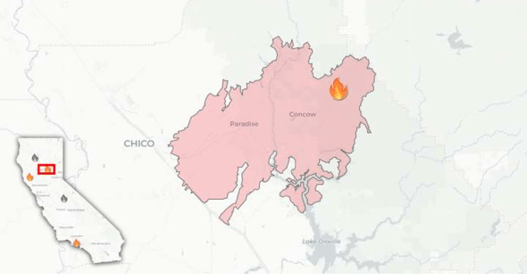
The maps of outages are haunted by the regime of these fires, as the Camp Fire quickly assumed its status as the deadliest of California wildfires since 1991–even if the category of “wildfire” is not really correct, as its causation or its expansive burning can be called wild–as it became the Butte County fire, moving out from Paradise, CA, it lacked any clear provenance, and seemed to spread in the new landscape of housing density amidst the woods.
All residents of the Bay Area are perhaps haunted by the specter of these fires, even if they did not travel to see it. The name of Paradise, CA, chosen by gold miners who arrived from Sacramento and the hot valley, haunted the ferocity of a fire that spread quickly on the ground and left its trace in the air, its smoke entering the Bay Area, as readers of online news eerily began to feel it in their noses and lungs by Thursday, watching its mapping from Wednesday morning through Friday as they were increasingly blanketed by smoke by late afternoon and of course through Saturday–


–that we could descend under, leaving toward Chico–


Thursday, November 8/Don Thompson, AP
–as we raced to our screens, both to get a better sense of the on-the-ground imagery, and to get perspective on the disastrous scale of the raging fire we needed to process in a broader picture, the fire became a nightmare of the new relations of the on-the-ground relations. It was impossible to process the effects of climate change on thee quite apocalyptic nature of the experience of smokey skies the cover much of the area I live; hoping to make sense or gain a grasp of a site almost immediately destroyed by 10:45 on November 9, 2018, leaving hulks of abandoned, burnt out cars on the roadside.

Highway from Paradise, Calif., November 9, 2018 (Karl Mondon/Bay Area News Group)
The broad spread of the fires’ smoke, and the deep dangers of inhalation they posed, generated a supplementary genre of smoke maps, of the second-order impact of the ranging fires. The California Wildfires Map that ESRI released was accompanied by a cool visualization based on the National Weather Service forecasts in its “Smoke from Wildfires”map that slowed us to visualize the spread of smoke in the future, from a broader range of fires, to be sure, whose spread provided a sense of the broader ongoing problems of containment in a fire that was still only 20% contained, particulate matter spilling into the Central alley and across the Bay Area, lingering over time as further smoke arrived over the Bay and passed over the entire state.

What there any position of empowerment or understanding that could allow one to grasp it? The expansive fire that a shortwave infrared view allowed created a cool satellite picture of burning flames running from Paradise, CA across nearby crests, suggesting the difficulty with which it was pushed by winds. It suggests the illumination of most every individual house in the image, where the heat was greatest, it is cleaned up of all the smoke that emanated from its fire lines, oddly removed from the actual costs: the image moreover situates the fire in a lush green countryside of the Sierra, “seeing” through smoke and registering a detailed image of heat variations, able to go under the smoke, as it were, to show the extent of burning and areas of future spread. The image uses the authority of the image to create a falsely comprehensive sense of the actual fire–obscuring the costs of smoke spread, pollution, and the destruction of the trees’ biomass–and the loss in carbon retention that it bodes, as well as of human life and property.
The curious intensity of the spread of fire in Paradise CA and surrounding area is matched by a limited record of the fire’s spread that only partly suggests the changes in containment strategies on account of the great aridity of the wood underbrush, lack of air moisture, or the gustiness of local winds: the abstraction of the fires from the broader setting or intensely dry setting suggest a limited mapping despite the comprehensive detail offered by Digital Globe, where the progress of the fires is less the point than the devastation they have left in their wake–the dead forest noted in yellow-brown, in contrast to the blue of healthy forested regions.
The naturalistic surface of the map of course also obscures that the fire is located on that wildland-urban interface, the expanding area where city meets sprawl, and infrastructure extends into densely wooded lands, a new topography–and a growing one in California, where housing is driven by escalating urban costs of ownership or renting, and a ballooning population–that created unique demands for firefighting at the same time as fires have grown more destructive than ever within.
For the same reasons the the fires in the wild lands have been allowed to burn as a matter of good foresting policy, whose towering walls of flame are not worth fighting and cannot be fought, the wild land-urban interface is the hardest to contain, and rather than protected state or national lands, are settled by humans who were themselves unaware of fire risk, and where the fire spread at the rate of a football field every second. The problems of the management of these fires are suggested in the Digital Globe imagery–nothing stops the Camp Fire’s advance!—

–letting us wonder about the dynamic that allows this speed of spread, from anomalously parched ground, scrub, and trees to sustained high winds, or the effects that cascade down a far broader geographical expanse, channeling smoke that blankets not only into the more populated Bay Area but the Central Valley’s agricultural fields. The dense smoke plumes drifted far further than the area destroyed which continues to be consumed–and ridges that would be as “wildlands” allowed to be kept burning as they couldn’t be combatted clearly, are far closer to settled to areas, and their impact is of broad public health concern, both as smoke was released from over 130,000 acre burned and over 6,700 structures–far more than in the North Bay Fires–fueled by extreme weather and winds up to 50 mile an hour, destroying houses in spectral manner that seemed straight out of Lord of the Rings, haunting memory and creating a powerfully catastrophic image of the firestorm’s destruction that would be indelible for many.

The fire spread from an area where only 26, 000 lived–not parkland. By the early weekend advanced toward Chico, while burning east, further into the Sierras. It was held back from the more populated areas; “the worst-case scenario” materialized as the now-destroyed mountain town of Paradise lent fuel to the fire’s spread fanned by strong winds and arid air created by sustained high temperatures and an absence of necessary groundwater or rain, as the area of the fire grew to the size of a city and Butte County sheriff directed resources to the searching for bodies under the ash. The images of fire activity were not encouraging. Maps increasingly cast the fire as an actor in its own, conjured as if magically or satanically from the new terrain of a warming world, as if to register the new nature of the fire regime it was created by or had created.

Online time lapse maps of hourly AQI tracked elevated danger flags spreading across the populated Bay Area, of consequence to elderly, children and asthmatics, again posing considerable danger of public health, in an eery reprise of how last year’s North Bay fires radiated smoke from Santa Rosa and Marin, or the flames from Yosemite, all fanned by winds during the dry seasons of late summer to early fall in the expanding fire seasons of the American west, of shifting parameters and goalposts due to global warming, revealing the increased lack of bearings we have on the world even with the best maps: with only 20% containment of the Camp Fire by Sunday, increasingly poor quality air blanketed the Bay Area.

The focus on air quality may have appeared to appeal to the self-interested natures of nearby bourgeois, far removed from the dynamics of climate change and the tragedies of fires in the wildland-urban interface again. It involved us with new urgency all in this often unexplored or analytically undervalued new terrain, forcing us to turn our attention to the ecological consequences of poor construction practices where most of these fires have begun, or the difficulties in containing them.
Tthe ancillary problem of the pollution of the air–the most common of public resources, the shared substance of our lives, what remains, as it were, of a true common space–offers a profound reminder of the ways that the extended raging of fires poses a deep disruption to our notions of public good and public space. The scale of burnt areas of the fires challenged the spatial imagination not only of Californians, but of the world at large. The very air seemed itself infected and polluted by the Camp Fire’s smoke, undermining a broad sense of common good at the height of autumn. And the observation of park workers that in “years like this, with four to five fires burning around the state, the wind can carry the smoke from one fire out and just bring the smoke from another fire in,” expanding past any easily disseminated mappable boundaries of fire danger, far beyond the “perimeters” of the fires noted on most maps. As the Mendocino Complex widened to offer 275,000 acres, and then past 290,692, still barely a third contained, we gained precise measurements of its perimeter, loose bearings on the fire’s fierce expansion and rapid destruction of land,–perhaps too overwhelmed by measurement of ground consumed-in ways impossible to process, to process the new terrain of fires or the new burnscape. The current rash of burning that incinerated all of Paradise in the November 2018 Camp Fire seemed a true holocaust.
For in an era of intense global warming, where the scale of the fires’ behavior and rates of expansion overwhelms familiar metrics and is focussed more clearly than before on the urban-wildland interface. If the North Bay Fires of the fall 2017 were triggered by electrical sparks meeting ncreasingly combustible groundcover, the fall of electric wires the seem to have triggered the Camp Fire that so quickly spread also distinguished it from the wildfires that until recently were predominantly caused by lightning. With fires arriving earlier, and their containment more difficult and indeed more exhausting. The increased penetration of of suburbia and extra-urban areas into woodlands has created an increasingly combustible area of housing, the site of a huge expansion of the settlement of much of California’s population explosion, and the arrival of houses organized with a poor sense of defensible space.
The clear difficulties to distinguish risks to an area where electrical sparks can create consequences of fires’ rapid spread in partly rural suburban areas, where expanded housing markets have grown without adequate preventive practices of clearing defensible space, controlling dead grasses and ensuring building codes and regular landscaping to prevent the risks of fire ignition in the semi-rural areas where many of the California where the most notorious fires have spread near Redding, Mendocino or Santa Rosa, or near Chico, or Malibu; these fires stand to change the atmosphere of the state and its landscape, as the dried out vegetation of forests has provided a basis for the fires’ spread across something like 243,000 acres, in one of the most destructive fire-“seasons” in California history.
We all had clear memories of how North Bay Fires and Camp Fire reached us not only in horrific images, but spread a layer of soot that spread from Santa Rosa and Vacaville over Oakland and the East Bay, down to San Jose and Portola Valley and Salinas. The fires brought distinctly different taste of the air one could immediately notice–crumbly, chalky, gritty, burnt–”Y’know, I don’t remember it ever being as bad as this–funny,” a neighbor stoically noted as he entered one of the two cars in his driveway–that we recognized with wariness and unease, premonitions of fear of a new eventuality of how expanding fire seasons could change the region; as the smell of plumes of soot and unhealthy smokey altered the quality of the East Bay and Bay Area we had known
The poor air quality that settled over the Bay Area was not nearly so grave as the losses that nearby climate refugees whose homes, livelihoods, and possessions were destroyed. It was hard not see their fates as of a piece with a violation of the commons, or stress on the commons. The fires immediately prompted many–including myself–to search fruitlessly for breathing masks, lest the deep unhealthiness of these fumes, or at least the maps of AQI that were broadcast reflexively and widely; as concentrations of particulate matter increased to an extent that was worse that Beijing air, and was registered as far down as Santa Cruz and–in some accounts–down to Mexico and up to the Sierras, in Truckee, a cocktail of wildfire smoke of high nitrogen oxides and ozone levels, and particulate matter from heavy plastics, mixed in our lungs and hung outdoors in a haze not likely to dissipate.
It may be odd to say that the purchasing of masks became an odd resurrection, or search, for a commons, as the chit-chat among customers grew in an attempt to collectively register among our narrow demographic what was occurring nearby as we waiting fro new shipments of filter masks to arrive at the local hardware store–the only store still able to procure masks, putting a heavy onus on the staff. If the Occupy movements the past were about a reclaiming of public space, and a resistance from housing advocates, labor, and a response to repeated housing crises and gentrification of much of the region, and displacement outside the urban environment to surrounding outlying areas, beyond the “commuting distance” of a city, the new boundaries of smoke danger are disorienting, and lead to attempts to articulate a sense of urban justice, and social justice. They raised pressing larger questions of the inequality of environmental injustice, or the upsetting of structures of justice, as far, far from the fire, as San Francisco’s department of homeless services had distributed about 1,600 masks to homeless, refugees ran from destroyed homes, individuals were incinerated. We were sensitized to the process over time, and had at least a reflexive response in place. If the Yosemite fire exposed residents of San Francisco, San Jose, and Los Angeles, residents to high levels of smoke and unsafe atmospheric pollution, remaking the Bay Area’s air quality deteriorate to being ranked worse than Beijing in the local paper’s front page, attempting to create headlines worth their weight in clickbait at this point–the Camp Fire had mobilized more firefighters mobilized across the state than for any previous–but this was immediate, this was out of control.
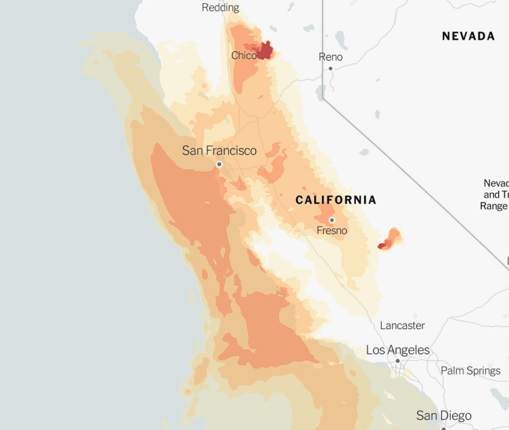
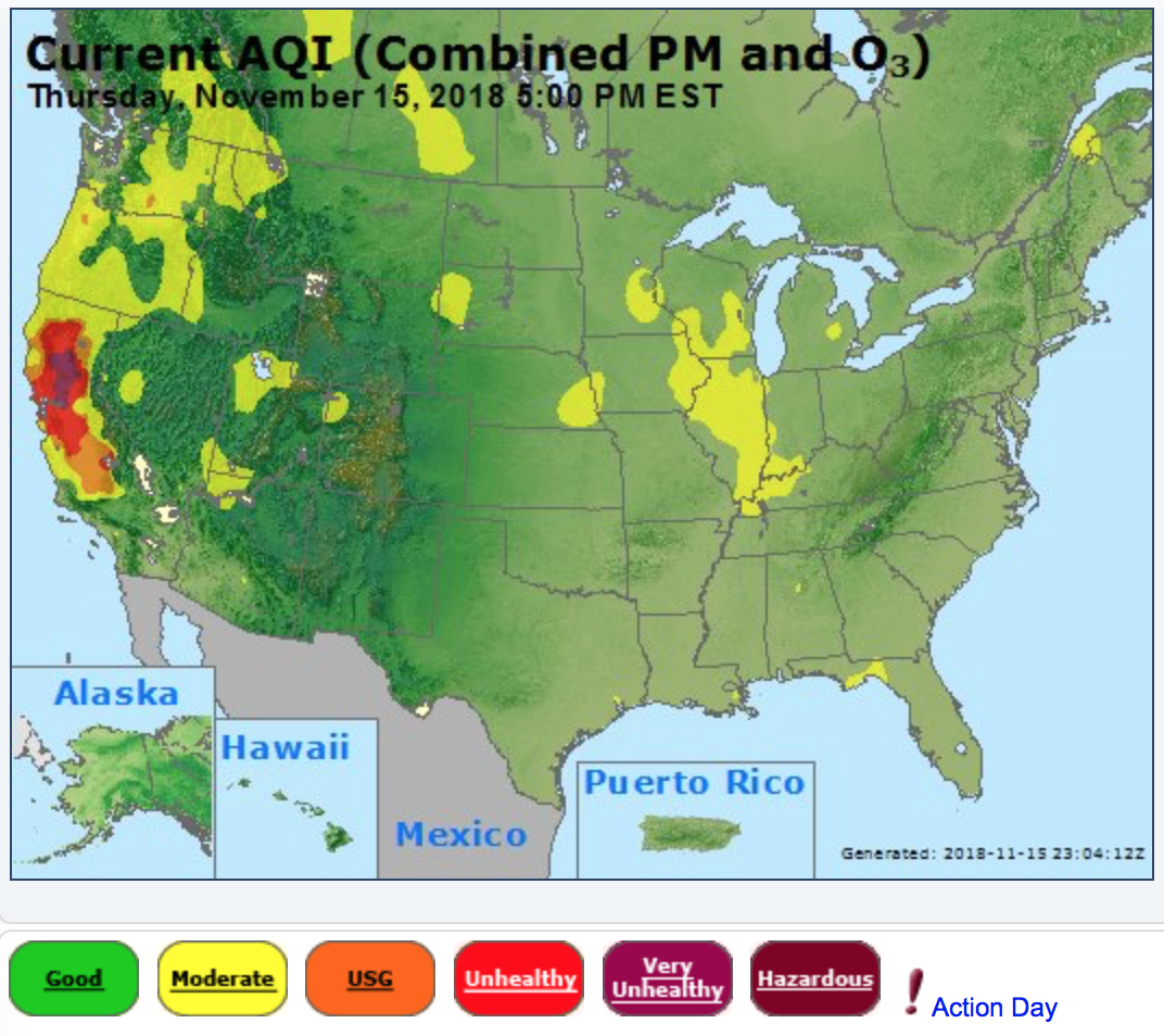
Fire season haze in the Bay Area has again commanded attention this November, where city dwellers were exposed to enough micro-particles as a half a pack of cigarettes a day. The extent of poor air quality that had been literally registered as a dot was now a blot on the nation in smaller-scale maps of the national air quality. The contrast to the bucolic green of what seems safe air across the rest of the nation –the result of a region that went over two hundred days without relief from any precipitation–was a refreshing change from the red state v. blue state imaginary. The intense anomaly of air quality made the nation appear infected by a growing and malignant organism–more than a tumor, a site of active growth of untold rapidity or scale, as winds fanned flames and sent the particles to lodge in lungs across the state, creating a real sense that there were no more borders any more, as smoke spread from the deep, dark carmine, to which we were suddenly more than symbolically connected, as fire ash entered our bodies.
As offshore inversion layers allowed further smoke to accumulate in the Bay Area–and the region to “go purple”–increasing panic of residents in the health of any outdoor activities, and interrogation of what the metrics for healthy air actually were. Going purple or entering “very unhealthy” air quality in the most populated areas of the Bay was almost unprecdented, since last year’s fires.

We don’t exactly have a clear division between nature and culture in California, or the United States, and the notion of burning dead tries and dried branches, and occurring in a relatively open space, made it count as something wild. Beside, the ranging of the fire was out of control, devastating human settlements and leaving many without homes, property loss, and haunted the nation with spectral images of a remote forested site covered with smoke, white was projected to clear in much of the more populated Bay Area–though not as soon as residents might have wanted, and haunting the cities of San Rafael and San Francisco, through Monday, as the ozone and particulate matter was projected to disperse from the more populated areas, with these predictions that the red danger zones would contract, even if yellow and orange hardly suggested healthy outdoor breathing air along the coast, or in Oakland, and remained considerably dependent on the predicted wind velocity: the lessening of Ozone and particulate matter around Santa Rosa or Livermore hardly changed things in Oakland or San Francisco, despite sense of general lightening: indeed, the red pools around the populated areas suggest the ways that the Camp Fire’s smoke didn’t produce, retained by an offshore inversion layer that ensured a layer of smoke would remain at ground level.

