
The flexibility demanded to examine the changing settlement patterns of Northern California, and the protection of wildlands that have defined the state, are far more complex than the expansive maps of potential electric outages across extra-urban areas PG&E provided users as the gustiness of the first winds that marked the start of the 2019 Fire Season.

Columnists have little helped by offering more disorienting click bait pronouncing on a questionable future for California as a state–the “end of California as we know it!”–as if the poor preparation for the fires area a rewriting of geography–rather than the other way around. For they cast local intransigence as if this distinguishes a state known for its innovation and accommodation to climate extremes. A sense of emergency cast “California’s problems” as a local tension of intransigence and idealism–can climate emergencies ever be local?—as argued by Farhad Manjoo, a technology and media columnist turned opinionator for the New York Times, living in northern California, with almost Lutheran predestination, stemming from illusions of “endless water” and “endless space,” as if this mistaken mindset lay at the root of the fires.
The argument as obscuring of the actual landscape as the now notorious outage maps, whose aqueous lines snakes up extra-urban areas as if to indicate a seas of liability for an already underwater utilities company, obscuring deep environmental changes intersecting with global warming. Manjoo harps on twin misconceptions long embedded in the state’s cultural history for his readers–echoing Kevin Starr and others before Mike Davis indicted the poor management of natural resources. Manjoo’s recent apocalyptic recitation of “the end of California” blamed poor local planning for challenges of a new landscape of a drying state that faces deep that obscures the creativity to climate and environment across the state. And it seems oblivious of deep–and increasingly steep!–challenges of a lack of precipitation mirroring the very contours of the state–
–that strikingly intersects with the administration of aging electric transmission lines.
The problem of supervision of a grid that extends across the state, carrying increasingly high voltages, is itself an illustration of the little oversight over the wild edge of California, or adequate integration of expanding urban environments in a growing “urban-wild lands” interface across the state. Even as the need to replace aging complexes was noted by the North American Electric Reliability Corporation in Butte, Yuba, and Sutter counties in Northern California had been tabled. The same area has become a site for the most historic fires in the state. Indeed, PG& tabled or didn’t prioritize their replacement, even after five transmission towers within the complex transmitting 115-kilovolt transmission towers on the Caribou-Palermo line in Butte County that collapsed and malfunctioned before the terrific Camp Fire.
The administration of such aging structures has to be considered public safety questions, in an era of such significant climate change, and the shifting meteorological challenges to administering such a power system.

California Energy Commission
The challenges to California are best confronted in its firescape, rather than writing columns that wring one’s hands at a mindset as if the the boundless “wild” long associated with the state historically seen as one of America’s wild edges lies at the root of poor practices of fire management, or should obscure the considerable resourcefulness and steep learning curve of fire protection in California, in what must be seen as a climate emergency–not a failure of local stagnation or inflexibility of governance. For even after 455 spans were analyzed across the transmission network, failure to improve hardware, provide new transmission frames, or improve tensions in spans of transmission line have raised regulatory questions that go beyond assessing fines.
If “wildness” as we know it has become less clearly bound in California that it once was, or was by those who celebrated the state as a new seat of wildness that would have been celebrated by Thoreau, but was accessible to all, the very notion of the “wild” has been challenged by the persistent lack of rain that has so curtailed subsurface water supplies so dramatically to starve trees, brush, and grasslands to be rendered increasingly vulnerable to fire. For the true emergence of how the parched landscapes of California have increasingly intersected with power lines that carry increasingly high energy loads to extra-urban areas has enabled the new pyrogeography of the state,–

–more than the mindset of legislators dragging their legs due to reluctance to raise property taxes, or even the evil deceptive realtors who have jiggered fire insurance rates to artificial lows that invited home buyers quite deceptively into suddenly fire-prone areas which they are only forced to evacuate regularly before the rapidly changing topography of extra-urban firestorms as the division between wildlands and cities is increasingly blurred–both in California, where the regions of what environmental biologists decided to treat as a new habitat and ecosystem of “Wildland-Urban Interface” has revealed itself as a new fire system in the twenty years from 1990 to 2010–

–as it has grown extensively during the same period across much of the United States in our current age of extra-urban property development.

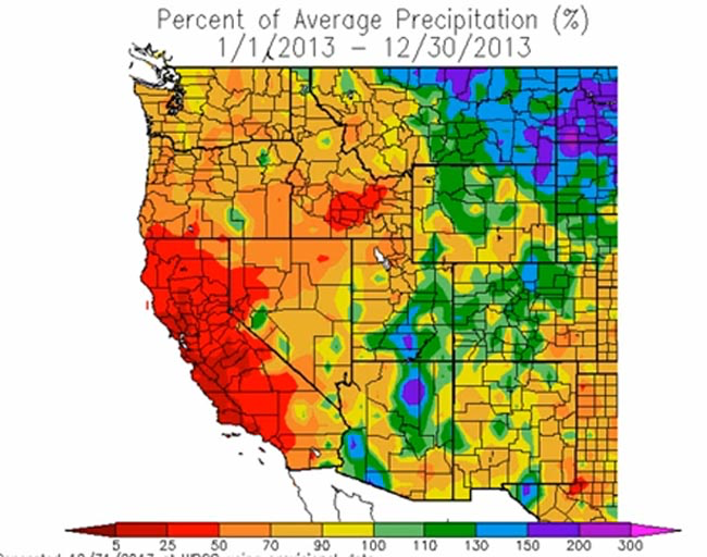
There is almost a gleefulness in attributing blame on local mindsets as not “currently designed [to] survive the coming climate,” such heavy handed criticisms conceal the fact that, more than elsewhere in America, in California, the climate crisis is a crisis in which much of the state is in fact already engaged–or how the densely forested geography of the state alligned with the driest years on record across a significant span of six years. For the outlines of the state of California have bizarrely become something of an experimental model for climate extremes, creating extreme levels of drought across the state 2012-16–a period that must be understood not as 2012-17 “drought” but as a massive change across the state in groundwater storage with statewide consequences.
Can one understand the difficulty of reacting to the current fires, and indeed the expansion of fire seasons, without this geography of water depletion? The new pyrogeography redefined the state’s threshold of fire readiness in response to the increased intensity, spread, and duration of fires, and its ability to spread over huge swaths of combustible terrain that coincided presicely with the administrative boundaries of the state.


Ever since Mike Davis attacked California for suffering a deep crisis of identity that left them unprepared for sustained drought, at the end of the 1987-92 drought, when he famously cautioned the danger of a return to extreme drought, the site of California as a site of purely “natural” disaster is as easily called into question–as the problem of the relation between extra-urban expansion and a drying out wildland becomes increasingly in evidence, not only in Southern California–the focus of Davis’ polemic on ecological management, The Ecology of Fear (1998), but the growth of fires in the very woodland-urban interface Davis described that has expanded in Northern California to generate increased risk of fire across such large swaths of the state–far outside of Malibu, whose strategies of fire-suppression he savaged in ways that won much push-back, but raised alarm.
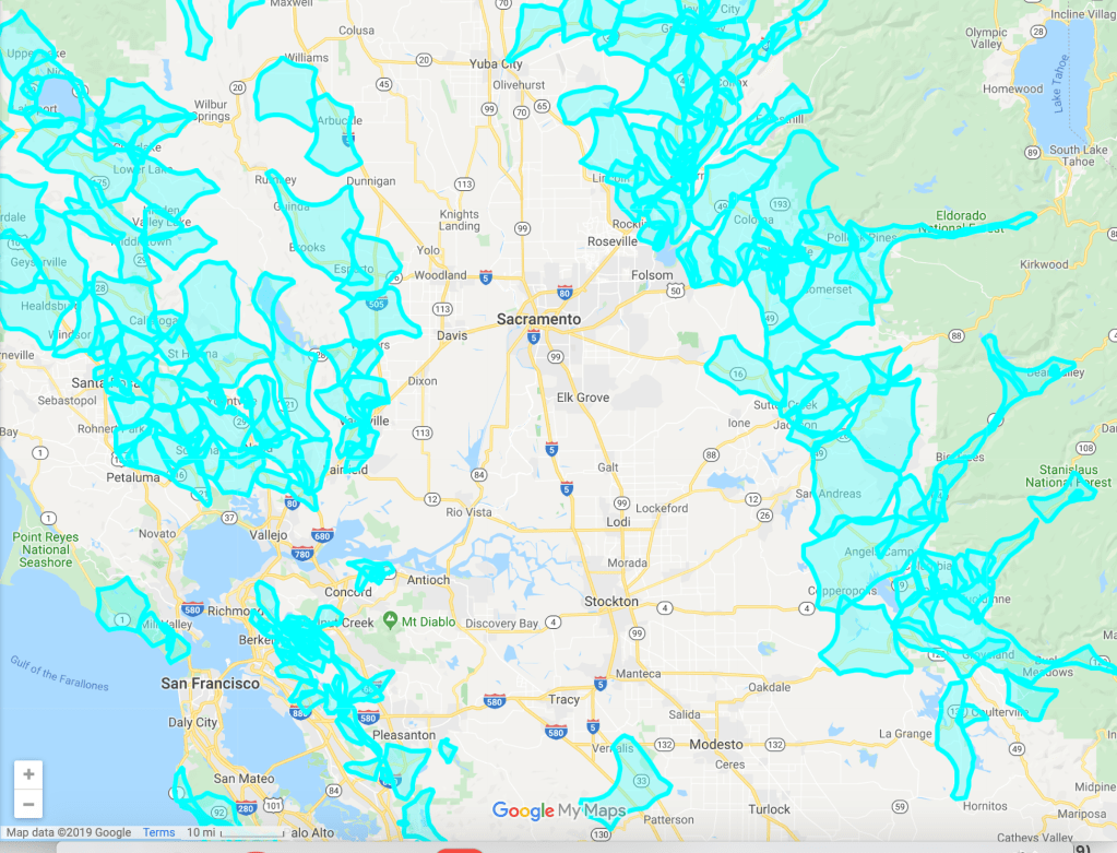
The lack of attention to the very geography Mike Davis rightly bemoaned decades ago as having been poorly understood by preservationist environmentalists or by wildfire experts has in turned provoke shutting off above-ground transmission lines as “preventive” measures. The map, while fairly opaque, and indeed so opaque to lead to tail-spins of searches for more accurate maps, used tiers of fire threats, as much as climate science or accurate weather predictions, ranked by the California Public Utilities Commission that PG&E was allegedly accountable. But they raise far deeper questions of whether such ignition be managed by power shut-offs–and the poor quality of outage maps as a metric of wildfire risk, and how questions of liability obscure the incommensurate goals of the for-profit company with the public interests of the state and its residents.

While these are not measures of risk, of course, so much as based on them, it seems important to observe that such maps reveal and create a further alienation from the landscape of fire danger, that seem themselves a clear betrayal of public trust and custodianship of fire danger, independently from the terrifying question of how many of the actual fires began from failures in weakened, damaged, or aging transmission lines that were part of the infrastructure of power PG&E maintains.
What seems to be the logic that led PG&E opted to create alarmist maps–indicative of a true emergency in their scribbling of bright turquoise layers to suggest areas that are at fire risk on social media for its users–at the arrival of high winds that threatened to start the 2019 Fire Season? PG&E had already feared that as the owners of private utility equipment they might face charges of beyond $30B in liabilities for the 2017 fires, leading to the creation of laws to shield the company from liabilities for as long as possible, even as NPR sponsored public warnings from the utility company instructing the public to report any downed wires, as if in hopes to diminish its liabilities for future damages, more in an attempt to keep its shareholders happy encouraged than respond to losses of the uninsured; fears of fleeing insurers leaving the state as it burns rose with rumored cancelations of policies of property insurance as increased risk of more frequent fires spread like wildfire in the state, after the Carr fire damages grew beyond $1.5 billion, leading Property Casualty Insurers’ Association of America to insist “California continues to have a competitive and healthy homeowner’s market,” even as homeowners in Santa Rosa, CA reported cancelled insurance policies as 25% of regional residences found to lie in “high or very high risk” area,–as many other home-owners found themselves to be underinsured for fire losses.
Introduction of new bills in state assembly bills mandate insurers provide information about fire policies, from 2017, although assistance to help victims recover past losses seems effectively derailed, but rising liabilities loom heavily over PG&E’s fate as a private corporation.PG&E, which has not invested funds in better safety practices, despite the faultiness of PG&E’s equipment and situation of electric lines. Despite limitations on liability for poorly secured electrical wiring and transmission lines, the inadequate mitigation of dangers of infrastructure expansion in the state. Even as PG&E was blamed for the recent rapid spread of the North Bay Fires, largely located in areas where electricity lines and wires had fallen during high winds and released sparks that unleashed several of the rash of fires, and promoted public warnings to notify the agency about felled power lines in different communities, questions of attribution, blame, responsibility or cause of the spread of fires belies the fact that their spread across a vulnerable landscape outstrips human agency and poses new questions of scale and continuity on a map. At the same time, the mapping of many fires over several years in the Wildlands-Urban Interface–at times incorrectly termed “wildfire-urban interface”!–have led insurance companies to withdraw from specific areas, or not renew policies, placing increased numbers of homeowners in a precarious position, and raising the specter of insurance loss in the absence of any stable rate structure. In this setting, risk is increasingly removed from human agency such as fire mitigation practices.
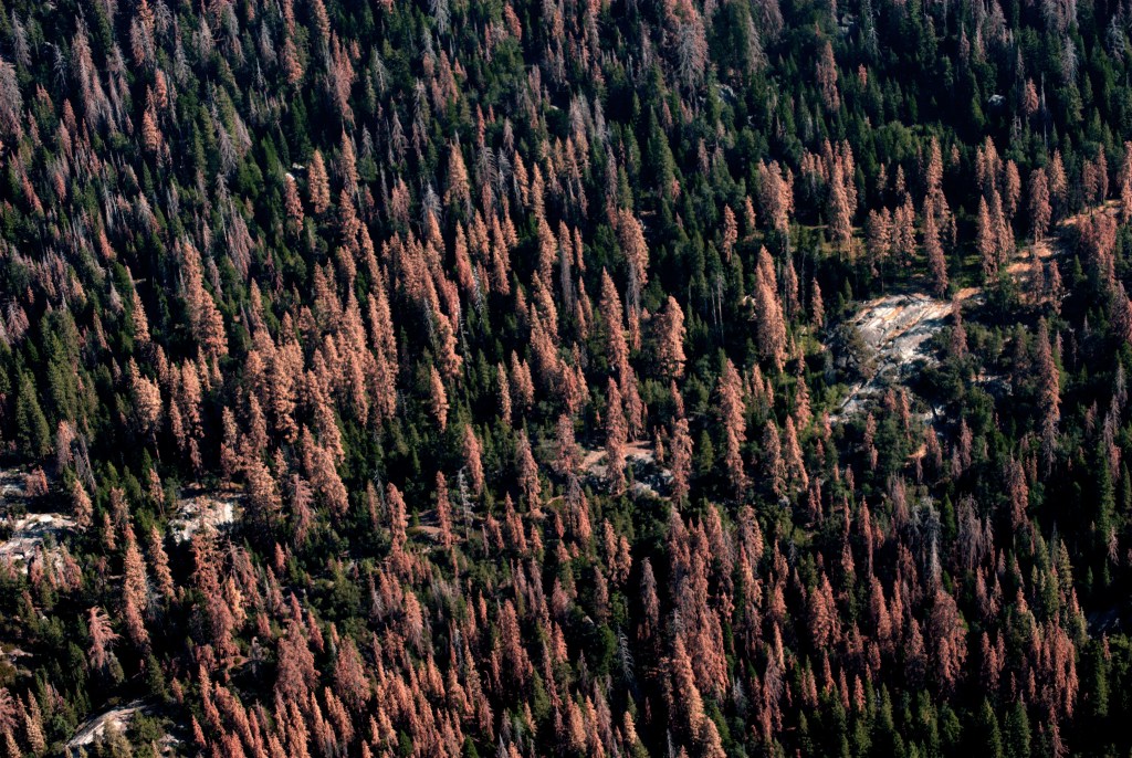
Yet the very fragility that seems increasingly pronounced in the very site of intense biomass of forested lands in northern California, still among the most wooded area of the nation, and the most delicate ecoregions of the nation, elevate the increased need of investment in practices of fire mitigation far, far beyond the imposition of temporary interruption of electricity in what were billed as “public safety power shutoffs” that were always only publicly described “as a last resort during extreme weather conditions to reduce risks of wildfire”–and, implicitly, reduce liability.
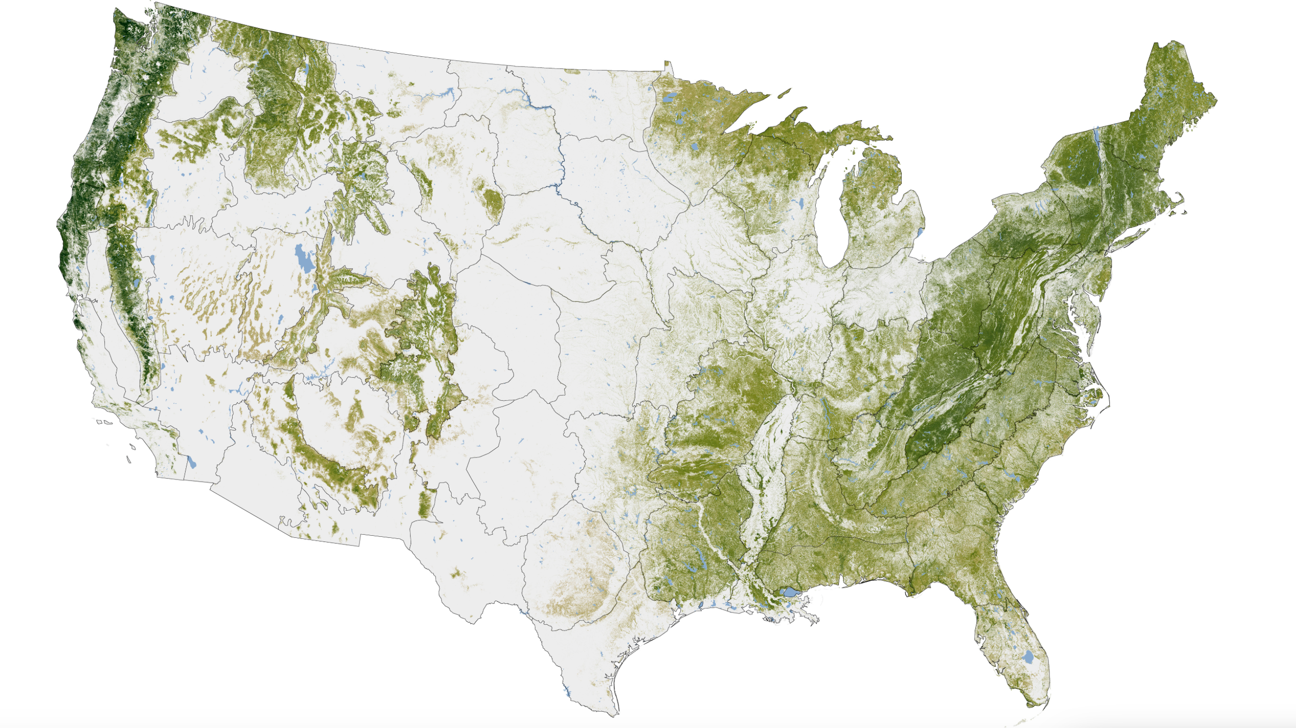
Biomass of Forested Lands in United States, 1999-2002/NASA

