
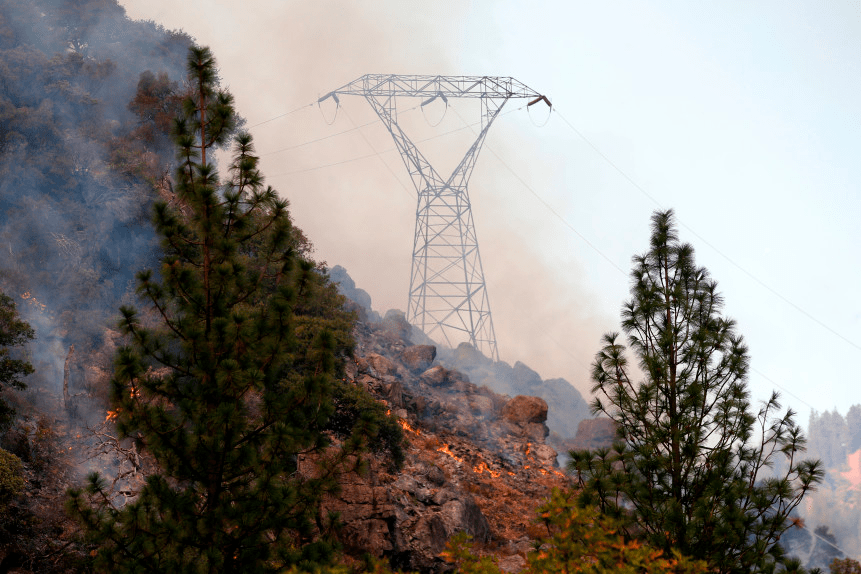
Most of the fires were concentrated in areas of extra-urban expansion where increased numbers of houses are built on tracts cheek-by-jowl wildlands that have increasingly run dry, and lacking adequate subsurface water below the elevated steel towers suspend wires carrying hundreds of thousands of volts of current–over 230 kV– into regions where similar levels of electricity had never so readily arrived, bringing with it the increased risks of fire in the parched landscapes of the state.

The actual decision PG&E made to reroute electricity to lower voltage transmission networks may prove an eminently understandable reaction, but also seems a breach of public trust. The improvised maps that PG&E readily released as gustiness grew across the state surely seemed little warning of what ensued, and the repeated threats of shutoffs that have followed as this fire season has grown. The selective outages that seem destined to create dark spots across California in future Fire Seasons are in many ways only another form of keeping Californians–and the nation–in the dark as to the scale of modifications and interventions in the electrical infrastructure that has grown too quickly without proper safety measures, often by adopting older infrastructure to carry higher voltages of electricity to customers, without concerns for local vulnerability.

The sense of a constrained landscape of habitability was the prime effect of the fear of renewed fires of uncertain contgainment and management in the coming fire season, for which extensive power shut-offs were planned. From the startling image offered by Patty Davis of Ronald Reagan leading his daughter to the site of lands scorched by fires in Malibu in the 1960s, telling his daughter with relentless optimism that green shoots were indeed growing out of the chaparral and destroyed grasses that was reduced to blacked ash, instructively sagely telling his young daughter that “Life always finds its way back,” shaking his head and smiling, seeking to reassure his daughter as flames engulfed the landscape, we move to the pronouncement of Times columnist Farhad Manjoo of the “end of California as we know it” given our failure to live sustainably.
To be sure, it is hard to gain purchase on a world where the global air quality map creates striking equivalences between the Golden State and what was once the Third World or Beijing. The eery sense the landscape of the past was definitively departing inspired undoubtedly unwarranted panicked reactions, or at least misdirected apocalyptic tones. Patty Davis declared the California of her youth and its optimism to be definitively gone, lamenting the destruction of wildlife and homes; the more entrepreneurially oriented Manjoo exhorted America to “do better” although what that would mean was not left clear, save that the fires were growing and burning with greater intensity than we are able to track or keep pace. Wildfire management is increasingly more costly, and fire-fighters increasingly overtired from round-the-clock shifts and indeed facing greater risks, maneuvering on winding roads in peripheral regions, as blazes consume houses to create infernos they can barely contain. The mapping of the new “destruction rate” is firmly located in the interface of built developments and wilderness in extra-urban areas, and especially those areas of Wildland-urban interface and wilderness intermix, and the radical spatial concentration of destroyed buildings in the state.
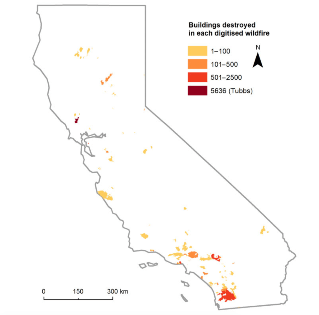
This map of the concentration of destructiveness suggests the new topography of the destruction of property across the state.
As others accuse politicians in the state for short-sightedness or refusing to fully prepare and “pony up” resources as if they were not living in the climate reality that the world has created, blaming the state for a failure of inventive approaches to fire-danger, the new scale of risk has indeed created new challenges for global inhabitability that geographers would do well to reflect on, and can provide a starting point for some of the answers. For we clearly need better maps, and more responsible ones.
Accusations of a lack of imagination in preparing Californians this year’s fire season stands in contrast to the many things learned about confronting fires’ spread, fire risk, and spark-driven fires, the long-term planning that distinguish not only many Californians but the state government. Both run sharply against the tenacity of PG&E to retain a coherent monopoly on providing power across the state–and that its control remains in “the long-run interests of all customers in the communities we serve.” But what community is truly being served, aside from that of the backers of the utility company desperate to seek bankruptcy protection for the start of the year, facing the demand to shoulder liabilities beyond $30 billion for past property damage or deaths attributed to “wildfires” to obscure any sense of agency–under the cover of a broad, state-wide reluctance to envision the new scale of risk, firestorms, or the new pyrogeography created by climate change. If PG&E admitted to “missing numerous trees” whose branches, limbs, and dead foliage demanded attention, it declared itself unable to manage the drying out landscape of the state, even as the energy corporation retained control over state-wide transmission lines. The maps of the planned power shutoffs PG&E issued were the skeletal echoes of these new landscapes, but were removed from the glowing and almost radioactive landscapes they described.
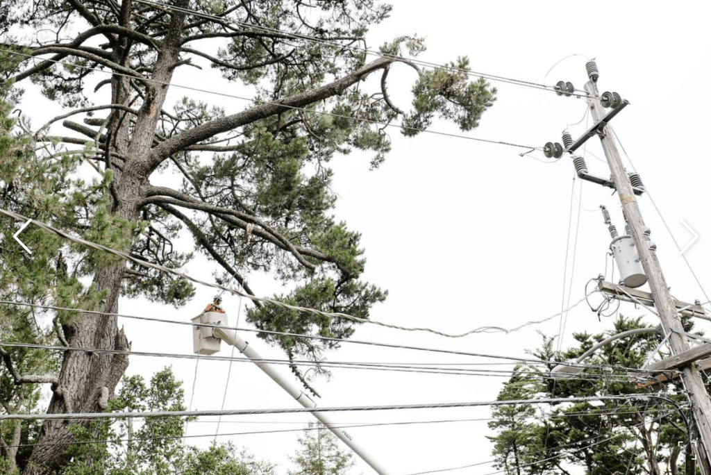

The decision to cut off large power lines–as the structure depicted above–preventively seemed to fail to take into account how outages would affect populations in much of the state. The shutoffs prominently map onto the very zones of increased extra-urban development, where urban populations intersect with undeveloped “wildlands” recently rendered increasingly flammable as the woods, trees, and brush lack underground reserves of water, and have become increasingly vulnerable to electric sparks from collapsed cables carrying high charges of 115,000 volts and higher that fall during increasingly gusty winds. The huge range of electric transmission lines that remain PG&E property in the state–

–were built long before current conditions of climate extremes, but over the last five years of fires have been unable to be changed or modified save in power line shutoffs, a theory that has been aired before the California Public Utilities Commission, but whose roll-out proved to be disastrous–partly because few could have predicted that PG&E could have rolled them out so quickly and suddenly in response to sudden weather changes and predictions of gusty wind, and a deep lack of its own resources to accept liability over the electric structure that the courts have determined it was in fact responsible to maintain. As the energy company insists it is protecting the “common good” of its customers, or that its interests coincide with those of the state. The revelations that the electric company has not organized coherent maps of its expansive grid–or of the weaknesses within transmission lines–were echoed in the poor explanatory value of the layers superimposed on state maps to suggest where such shutoffs might occur, whose broad expanses triggered increased panic throughout the state that the light blue colors of potential outages did nothing to assuage.
Indeed, the questions of the “livability” of the state have led many to try to calibrate the apparent expansion of levels of risk across the state–from loss of property, fires of ever-expanding size and destructiveness consequent asthma, high particulate matter counts, economic crowding, and alll coupled with high property rates, that seem to expand the previous fears of disasters that seemed more natural–even if the apocalyptic fears of earthquakes were as immediately destructive. As Emily Atkin allowed “at least there’s no hurricanes . . . yet” in California, she came close to pointing at the global scale of the culprit that we are witnessing in our alarming weather maps and AQI charts, if the existential demographic scissors that Annie Lowrey observed between the housing crisis in the state that has sent urban populations into extra-urban sprawl, relatively new to California’s landscape in the North in such density, which created a fire-risk level three times greater than other states, in large part, as the building of extra-urban developments in additions and parcels has bloomed in those very areas where the enforcement of building codes are far less vigilantly observed, beside undeveloped areas. The perfect storm in California suggests a very specific geography where climate-readiness was not closely observed.]

