
California’s legislature had tried to extend support to the utilities company in the wake of previous fires to spare it from previous wildfire liabilities; the reluctance to extend any similar security to PG&E has turned to anger in the face of the current destruction, however, reflects huge discontent with continued abilities of forest management and outrage at the scope of the devastation of local neighborhoods, and the scale of the destruction of over 18,000 buildings in the Camp Fire. Even as the current scare has retreated, allowing air quality to improve for now around much of the Bay Area,
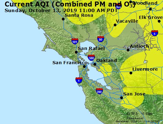
there are steep charges PG&E improperly maintains forested areas and trees in proximity to electrical wire–especially dangerous in a parched landscape that has lacked rainfall over multiple years. After the rapid spread of the fires of the Camp Fire, after multiple combustive wildfires to scorched the North Bay in October 2017 that killed forty-four, it is hard to single out poor maintenance as the issue at stake in the fires’ spread. Yet the corporate entity has become blamed on inadequate repairs, maintenance, or poor record keeping, as if such bad practices left state residents increasingly vulnerable. Even if most dismissed President Trump’s wilder claim that the spread of fires in Northern and Southern California were due to “gross mismanagement of the forests,” the notion of blaming the utilities company for its negligence seemed more credible. But building beside grasslands and desiccated forested land have created a new geography of fire and of fires’ spread–revealed in satellite measurements of the fearsome spread.
The liabilities that the power company was assessed for the destruction with which the recent fires’ spread undercut its credibility and increased a sense of its negligence, removed from the extreme weather the state has faced and for which few containment strategies exist. To be sure, the demand to define a felon seems to have overridden the danger of placing transmission lines near forested areas without rain. The aftermath of the fires–perhaps critically the time since Paradise, as it were–has created a sense of nervous breakdown in assessing, monitoring, and mitigating fire danger, it almost seems, as we rush to individuate and indicate clear blame for a changing climate and a lack of response to a decreased level of precipitation rarely experienced, in the need to identify a clear cause or victim for such massive and persistent disequilibria that undermined the public good and well-being in the apocalyptic fires northern and southern California faced, and the terrifying alarm before maps of the fires’ destruction and accelerated spread, perhaps without pausing to consider inter-relations that create a radically new firescape. And the outage maps that PG&E issued to its clients as gustiness of winds grew suggested a similar remove from an overderied landscape, long lacking rain.
And the maps that were issued to make the case for the outages weren’t that convincing, seemed quite improvised, if they did alert customers to the impending danger of power outages as a response to contain future fires. The loopy maps that were recently issued by PG&E, California’s very own home-grown for-profit energy company, to its customers or “consumers” seemed a weak public wager of confidence. After hemming and hawing, apparently, about deciding how to respond to the forecast of possible high winds returning to northern California, a region over recent decades that is haunted by fires by every earlier autumn. Whether they actually prevented fires–as PG&E insists, and left us all to sight with relief–or not, the hodge-podge constellation of overlapping parcels of indicating potential electrical shut-offs was disorienting–
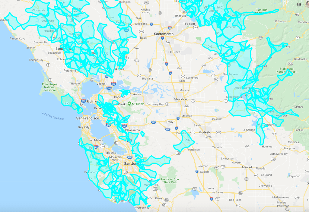
–and didn’t create more clarity by drilling deeper down into Bay Area neighborhoods..


Were the maps a warm-up for the difficulties of managing the threat of fire in a new fire season? Our “fire season” now stretches past winter, if not lasting all year, and its length has created such problems of management that PG&E elected to announce last Tuesday evening that the power was being turned off to over 800,000 of its customers preventively, affecting what might be upwards of 2.5 million individuals. It did so by exploiting an ability that it had gained after inadequately struggling to respond to past fires that had caused damage across the state, but intense loss of homes and property in Northern California, after the Camp Fire almost a year ago in 2018;, combined problems of infrastructural management and climate issues of a lack of rain it was unable to face, management of which was triple jeopardized after it had declared bankruptcy as a private corporation, which this time shut the power preemptively as the gusty winds began to blow.
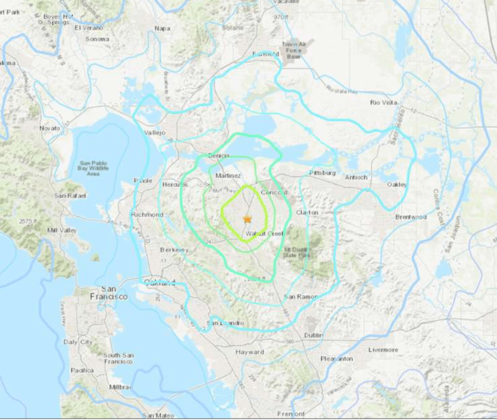
This being California, it was significantly striking that the turquoise rings seemed electrified version of the iconography of radiating earthquake tremors, and caused a comparable alarm.
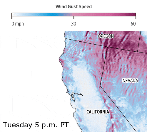
The maps were hardly much grounds of confidence, born as the board of directors hunkered down in preparation for those dry, warm wind of winter to sweep across Northern California. They were announced to be the result of the sudden arrival of “unprecedented fire risk,” even as the highest temperature anomalies recorded in the state had been published online since early summer, as dry autumn winds of increasingly high velocity returned to raise fears across the state, setting off alarms for a new geography of firestorm risk.
For “risk” in this case meant winds, and fire danger was understood as an intersection, as in a Venn diagram, between combustible undergrowth and winds that could carry dangerous embers from downed power lines–the apparent paradigm of recent outbreaks of what the media still calls–with PG&E–“wildfires,” as if they were due to a failure to thin the woods.
This may be the best optic through which to understand the awfully loopy maps that the company released, in an attempt to suggest that this time it really had the situation under control, or at least to dodge the danger of not seeming to have responded to verifiable risk. The responsibility of PG&E exercised over the electrical infrastructure of the state had led to its ability to monitoring weather privately to determine the urgency of shutting off residents’ power, allowing customers to consult a weather webpage to ensure some sense of transparency.–and security–until it crashed under broad demand for answers. The project of educating customers to the possibility of unprecedented outages raised questions responsibility and agency that many felt the private company had not been delegated authority to adjudicate.
The prediction of gusts of wind from the Great Basin over areas that still bear traces of firestorms created a broad sense of alarm, however, and with good reason. High gusts of dry air had spread firestorms of huge destruction, crumbling steel lattice structures of aging transformer towers that sent power lines crashing into dry underbrush, in Pulga, as low precipitation, low atmospheric moisture, and sparks led to particularly extreme consequences: debates about what “good forest management” has led to concern about the strength and durability of elevated electric wires knocked down by the force of high winds, pushing brush fires that became firestorms over vaster areas than firefighters had been used to manage–or fire fighters had even recently imagined. It led many to contemplate the stubborn fact that an expanded network of elevated electrical wires, bearing charge, running more prominently than ever before across a wild lands-urban interface, with terrifying consequences.

